Introduction
The broader territory of the historical region of Chaonia (southern Albania) remains largely understudied compared to the major urban centres that developed within it. The region’s topography has played a pivotal role in shaping settlement patterns over time. Its natural barriers, including the steep Ionian coastline and the imposing Ceraunian mountain range, have influenced both connectivity and defensive strategies. In the contemporary era, as has been the case in antiquity, communication routes follow these ridges and exploit the narrow valleys carved by the streams flowing into the Ionian Sea. The region’s relationship with the sea is characterised by a high degree of complexity. While the coastline facilitated connections with inland trade routes, the number of available docking points was limited to a small number of seaports. Consequently, a substantial network of hillforts was established on the hills overlooking the Ionian Sea. These hillforts served both defensive and economic functions by controlling strategic access routes and the landing points along the Ionian coast (Bogdani 2024a).
Despite their strategic importance and long diachronic occupation from the Late Bronze Age to the Middle Ages, these sites often lack systematic archaeological documentation, as research in the area has mostly focused on better-known locations, namely Phoinike, Butrint, and Antigonea. Preliminary documentation of the Albanian archaeological landscape was provided by early studies, beginning with Luigi Maria Ugolini’s Italian Archaeological Mission in the 1920s and 1930s (Ugolini 1927). Subsequent contributions, including Dhimosten Budina’s (1971) research in the mid-20th century and Ilir Gjipali’s (2007, 2009) studies on prehistoric and protohistoric settlements, offered valuable insights but lacked systematic survey methodologies (Jones 2017). The SITARC Project (Giorgi, Bogdani 2012), field research by the University of Macerata (Perna, Çondi 2012), and Kriledjan Çipa’s (2016) surveys marked a significant step forward by cataloguing sites in the districts of Gjirokastra, Delvina, and Saranda. Nonetheless, the primary focus of the research was a reassessment of existing documentation, with the generation of new topographic and archaeological data being a secondary consideration.
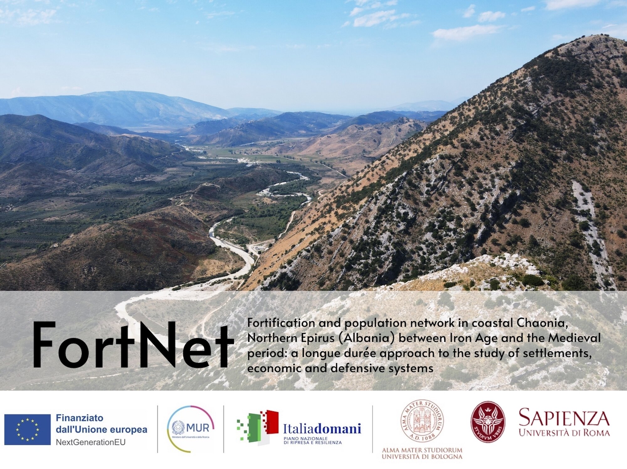
FortNet 1 is a joint project undertaken by the University of Bologna and Sapienza University of Rome that seeks to bridge this significant research gap (Figure. 1). By applying cutting-edge methodologies in landscape and upland archaeology, the project aims to provide scholars, local authorities, and stakeholders with essential tools for advancing scientific research, heritage preservation, and sustainable territorial development in the region.
Research aims and methodology
The objective of the project is to investigate the diachronic role of hillforts, with the aim of tracing their development from the Bronze Age to the medieval period. By examining settlement patterns, construction techniques, and material culture, FortNet seeks to address fundamental questions regarding the function and evolution of these sites within broader historical dynamics. The research is particularly focused on the chronology and motivations behind the emergence of hillforts. The factors influencing their development and significance, their relationship with major urban centers such as Phoinike and Butrint, and the role of intermediary sites like Borsh and Çuka e Ajtoit are also examined.
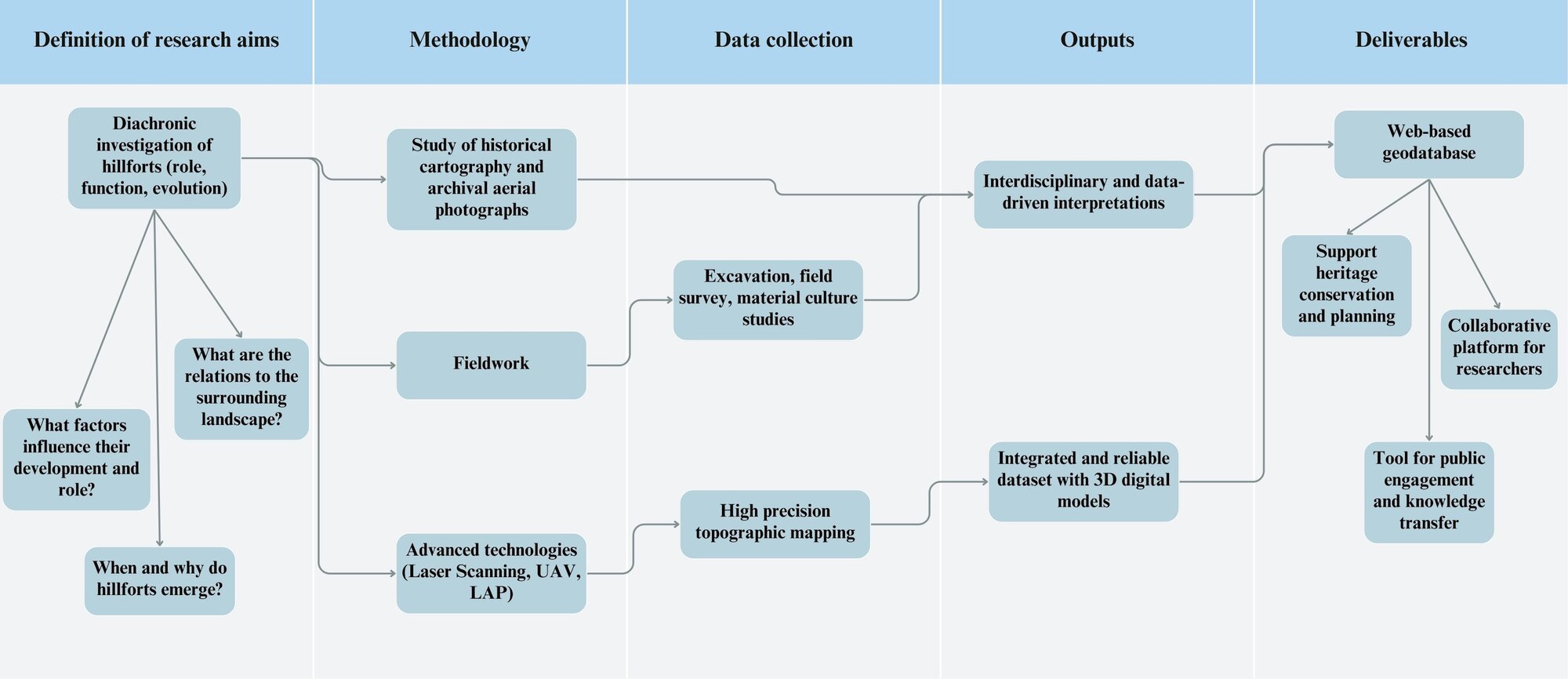
The research methodology employed non-invasive techniques, supplemented by surface find analysis (Figure. 2). The fieldwork encompasses the systematic documentation of sites through remote sensing and ground surveys. This process integrates historical cartography, archival aerial photography, and high-precision topographical mapping. The advent of unmanned aerial vehicles (UAVs) has ushered in a new era of precision in the realm of remote sensing, particularly through the methodologies of photogrammetry and laser scanning. These technologies have facilitated the generation of intricate digital models, thereby enhancing our comprehension of settlement structures. The project’s adoption of a diachronic approach is predicated on the objective of generating a comprehensive and reliable dataset, with the overarching goal of contextualizing settlement dynamics over time. This endeavour is expected to make significant contributions to the reconstruction of ancient landscapes and their evolution. Furthermore, the integration of advanced technologies, such as the Laser Aided Profile (LAP) method, has led to substantial improvements in the documentation of ceramic analysis. A fundamental aspect of the project is the development of a shared, web-based geodatabase for the storage, analysis, and dissemination of data. This tool ensures efficient, high-performance cloud-based data management and accessibility for researchers, while also serving as a collaborative space for integrating multidisciplinary research findings and fostering data-driven interpretations. Furthermore, the geodatabase assists heritage professionals in formulating conservation strategies, a necessity that has become increasingly imperative in the face of mounting threats posed by tourism and urban development.
Fieldwork
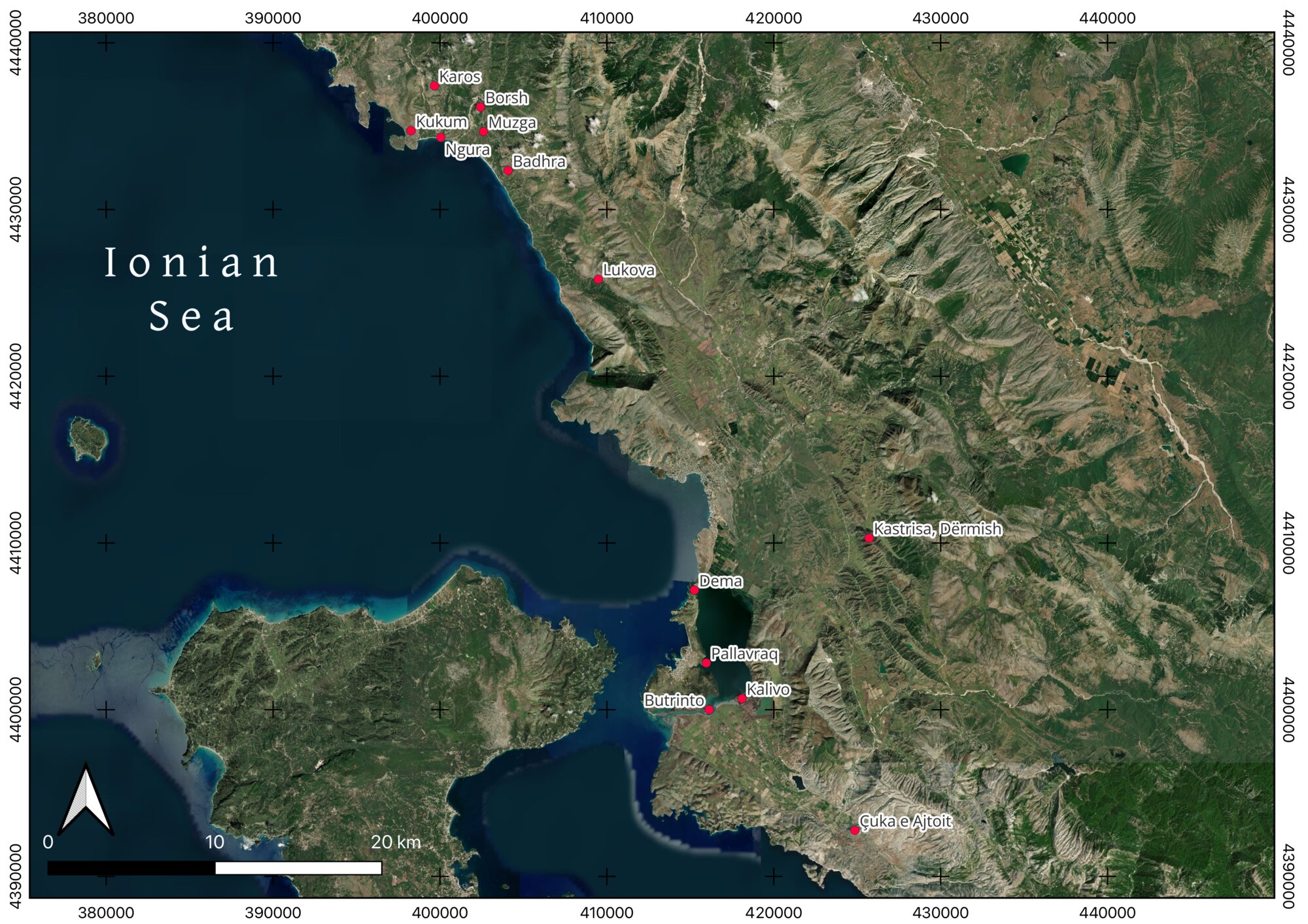
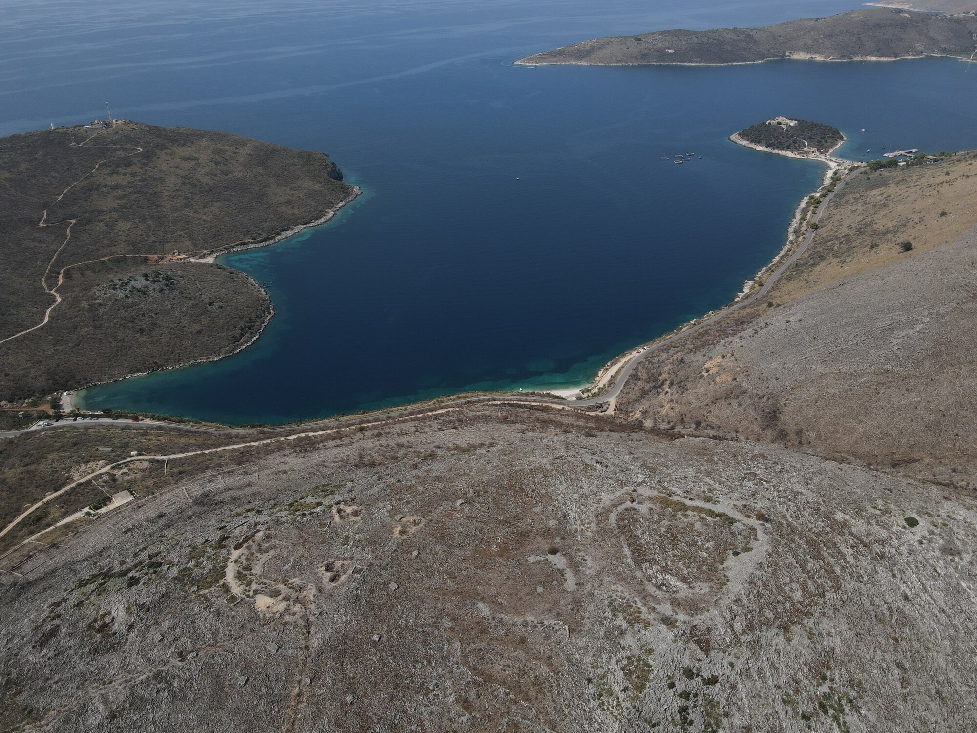
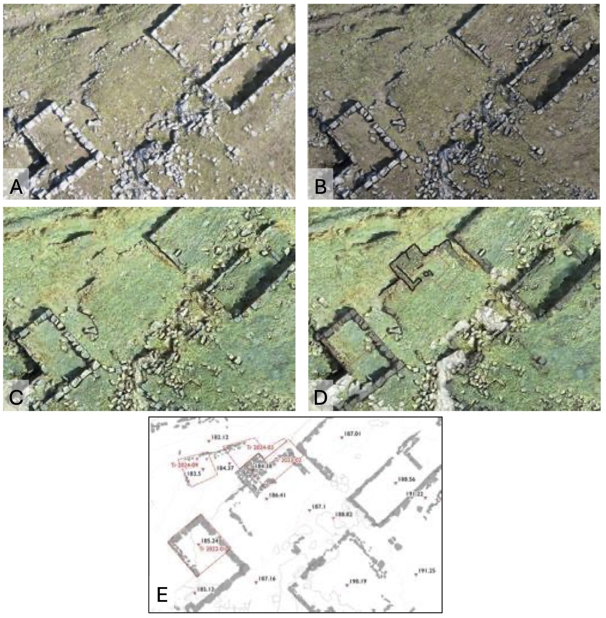
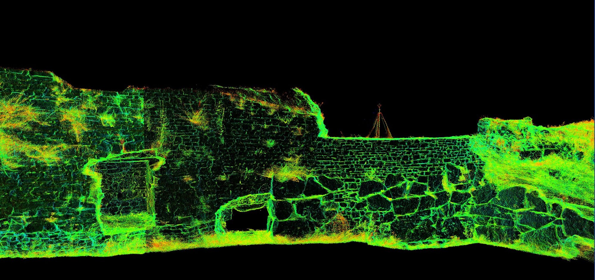
The execution of fieldwork w as facilitated by the ongoing archaeological initiatives of the University of Bologna at Butrint and the Sapienza University of Rome at Çuka e Ajtoit. The FortNet Project has engaged in collaborative research with the Archaeological Institute of Tirana, leading to the identification of three areas of particular interest (Figure. 3). The first zone is the coastal region between the bay of Porto Palermo and the Borsh river mouth, where the Ceraunian mountain range extends in a series of hilly ridges that directly overlook the coast. These ridges delineate a limited number of access points to the hinterland, primarily river valleys (Budina 1971; Çipa 2016; Çipa and Meshini 2016; Carbotti et al . 2024, 27–34). The natural communication routes through these valleys are controlled by numerous hillforts, as investigated by FortNet’s surveys. Their prolonged occupation renders them an exemplary case study for the analysis of settlement patterns. A comprehensive investigation encompassing fieldwalking and topographic surveys in the sites of Kukum, Karos, Badhra, Ngura, Muzga, Borsh, and Lukova has been undertaken. The findings of this investigation have revealed a continuous occupation of the area from the Early Bronze Age up to the Ottoman period. This discovery provides significant insight into the communication networks and exchange within the region and across the Mediterranean ( Figure. 4). The second area of interest encompasses Çuka e Ajtoit and the Konispol surroundings (the ancient region of Kestrine), situated along the southern border that divides Albania and Greece. Recent research has emphasized Çuka e Ajtoit’s role within the Hellenistic settlement system of Chaonia and its prolonged occupation into the medieval period, contributing to the understanding of fortifications, urban layout, and settlement chronology (Bogdani 2024b; Bogdani, D’Erasmo 2024; Bogdani 2023). Excavations have revealed the initial indications of Late Bronze Age activity at the site, along with materials dating back to the 4th–3rd centuries BCE in the area of the so-called “Palace”, indicating an earlier sacred function. Furthermore, the investigations have centered on the Venetian-Ottoman settlement, the Basilica of Çiflik , and Kisha e Psarit, which have yielded evidence of Roman and medieval structures (Figure. 5). The third area involves fortifications at the UNESCO World Heritage Site of Butrint and its surroundings. Excavations, surveys, and advanced digital documentation have yielded significant insights (Muka, Giorgi 2022; Giorgi et al . 2024; Rivoli et al . 2022; Aleotti et al . 2022). Research at Butrint has clarified the construction techniques, phases, and strategic role of its defensive system, particularly the Archaic wall circuit on the Acropolis and the Hellenistic city walls enclosing the lower city (Giorgi, Muka 2023; Castignani 2022). Meanwhile, ongoing underwater surveys have given some hints about the location of the ancient Pelodes harbour and identified the submerged remains of the Roman bridge piers, further highlighting Butrint’s role within the regional context (Giorgi et al . 2024a, 2024b). High-resolution photogrammetry and laser scanning have produced accurate models for structural analysis, while surveys in the Pavlla river valley and Vrina Plain have allowed to revise previously explored areas with new methodologies to enhance the understanding of the archaeological landscape (Carbotti et al . 2025) (Figure. 6).The study of material culture: methodological approaches and research perspectives
The project provides a unique opportunity to investigate different aspects of the material culture of this region of ancient Epirus at a broad regional scale, rather than being limited to single contexts/sites. The research has thus far concentrated predominantly on ceramic material from the ongoing excavations in Butrint and Çuka e Ajtoit. However, the significant data set from the stratigraphic investigations at these sites has led to the identification of several research issues on a regional scale. These issues have been implemented in conjunction with the findings from the surveys at the other sites included in the project. From a methodological perspective, two aspects of our approach to the study of material culture are of particular significance. The employment of LAP (Laser Aided Profile) for the graphic documentation of the pottery has resulted in a substantial augmentation of the digital drawings produced in the field, thereby establishing a considerable database on which to base traditional typological studies. Consequently, this substantial assistance has enabled a more comprehensive examination of classes that were previously deemed less diagnostic due to their paucity of research, including coarse and common wares. Furthermore, sampling of the ceramic material has been undertaken since 2023, facilitated by the financial support of two specific research grants from Sapienza University of Rome. The analyses were conducted at the GeoMLab Laboratory for the archaeometric characterisation of geomaterials of the Sapienza Department of Earth Sciences, through the following techniques: optical microscopy (OM), Fourier transform infrared (FTIR-ATR) spectroscopy and X-ray diffraction (XRPD). The initial findings of this comprehensive approach to the study of material culture have resulted in the emergence of novel research perspectives, particularly with regard to the pre-Hellenistic phases, which remain archaeologically elusive within the regional context. In particular, a number of sherds of handmade pottery of local/regional production from Çuka and Ajtoit have been referred to the Late Bronze – Iron Age, on the basis of their technical and formal features. This constitutes strong evidence that the site was inhabited even during this ancient phase. It is evident that a notable body of evidence pertaining to the pre-Hellenistic phases pertains to the probable local and regional production of Corinthian types A1 and B amphorae from at least the latter half of the 4th century BCE. This hypothesis provides a foundation for new research directions, particularly concerning the economic and territorial organisation necessary for managing the production of the amphorae, their contents, and the surplus intended for export. This period, specifically the Late Classical age, still remains archaeologically opaque in Northern Epirus.
Dissemination and community engagement
FortNet employs a multifaceted dissemination strategy targeting various audiences. A dedicated website functions as a centralized platform for the dissemination of real-time updates on the project’s mission, methodology, and progress. This platform serves to foster engagement with both the scientific community and the general public. 2To promote academic exchange, FortNet has organized workshops and conferences, such as the “Butrinto Cento (1924-2024). Bilanci e Prospettive” (Bologna, November 13th-15th, 2024), and the workshop “Living in the Town, Living in the Countryside. Typologies, Models and Transformations of Residential Architecture in Hellenistic and Roman Epirus” (Rome, January 15th, 2024). Additionally, team members actively participate in international conferences and seminars, presenting research findings to peers worldwide, and in activity of capacity building in digital archaeology and heritage management for both Italian and Albanian students of Archaeology. Public engagement initiatives are integral to the project’s dissemination efforts as well. Activities like the exhibitions in Bertinoro (Forlì-Cesena), Bologna, and Rome to remember the one hundredth anniversary from the beginning of Italian archaeological research in Albania aim to make archaeological knowledge accessible to local communities and stakeholders, fostering collaboration in heritage preservation 3. These comprehensive dissemination activities ensure that FortNet’s research contributes meaningfully to both academic discourse and public understanding of Cultural Heritage.
Conclusion
By shifting the archaeological focus from major ancient urban centres to smaller fortified settlements, FortNet introduces a significant research paradigm shift. Through extensive documentation and analysis, it explores human-environment interactions that extend beyond specific historical periods, thereby offering a more comprehensive perspective on settlement dynamics. The project’s integration of digital documentation, geospatial analysis, and archaeological research establishes an innovative framework for the study and safeguarding of Albanian cultural heritage. The project’s objective is to establish a new standard for the study and protection of Albanian fortified landscapes through the synergy of archaeological investigation, technological advancements, and public engagement.
References
- Aleotti, N., F. Carbotti, F. D’Ambola, and T. Kaca. 2022. ‘La ripresa degli scavi sull’acropoli di Butrinto. Considerazioni preliminari sullo scavo delle mura arcaiche.’ Cronache di Archeologia 41: 117-142.
- Bogdani, J. 2024a. ‘Chaonia in Epirus. A fresh assessment in light of new archaeological data’, in Redefining Ancient Epirus, edited by M. Melfi and M. Stamatopoulou, 37-61. Brepols Publishers, Borders, Boundaries, Landscapes 1.
- Bogdani, J. 2024b. ‘Documenting a hilltop settlement: methodologies and preliminary results of the joint Albano-Italian project at Çuka e Ajtoit (Albania).’ Groma: Documenting Archaeology 8 (2023): 18–36.
- Bogdani, J. 2023. ‘Documentare l’invisibile. Il progetto Çuka e Ajtoit: rilievo e documentazione di un sito d’altura‘. Archeologia Aerea XVI (2022): 89–101.
- Bogdani, J., and D. D’Erasmo. 2024. ‘Old Data, Old Methodology and New Research. A Case Study of Legacy Data Integration from the Cestrine Region, Epirus‘. Archeologia e Calcolatori 35, 2: 323–332.
- Budina, Dh. 1971. ‘Harta arkeologjike e Bregdetit Jon dhe e pellgut të Delvinës’. Iliria 1: 275–342.
- Carbotti, F., V. Castignani, F. D’Ambola, M. Rivoli, and G. Sigismondo. 2025. ‘Siti d’altura ed edifici rurali fortificati in Caonia (Epiro): considerazioni sul popolamento antico alla luce delle nuove ricerche’, in Landscape 4: una sintesi di elementi diacronici. Pianificazione e mondo antico: tra i dogmi del passato e le interpretazioni recenti, edited by G. D’Alessio, S. De Nisi, C. Felici, D. Gangale Risoleo, S. Pesce, I. Raimondo, 79-92. Oxford: Archaeopress. Cardini di Groma.
- Carbotti, F., F. D’Ambola, M. Rivoli, G. Sigismondo. 2024. Paesaggi d’Epiro. Archeologia dei paesaggi in Albania meridionale. Bologna University Press.
- Castignani, V. 2022. ‘Il nuovo rilievo delle mura arcaiche di Butrinto (Albania)’. Cronache di Archeologia 41: 163–178.
- Çipa, K. 2016. ‘Vëzhgime të reja arkeologjike në bregdetin e Jonit‘. Candavia 6: 81–102.
- Çipa, K., and M. Meshini. 2016. ‘Të dhëna të reja rreth fortifikimeve paraurbane në Shqipërinë jugperëndimore‘. Iliria 40: 59–95.
- Giorgi, E., and J. Bogdani. Il territorio di Phoinike in Caonia. Archeologia del paesaggio in Albania Meridionale. Bologna: AnteQuem, 2012.
- Giorgi, E., and B. Muka. 2023. ‘Sulle orme di Enea. Pascoli, laghi e città d’Epiro: le vie d’accesso a Butrinto‘. Atlante Tematico di Topografia Antica 33: 239–257.
- Giorgi, E., B. Muka, S. Medas, F. Carbotti, and V. Castignani. 2024. ‘Alcune riflessioni sull’archeologia della laguna di Butrinto. Approdi per terra e per mare‘. L’archeologo subacqueo XXX, 76, http://dx.doi.org/10.4475/0772_9
- Giorgi, E, F. Carbotti, and G. Sigismondo. 2024. ‘Butrinto in Epiro: archeologia di un paesaggio lagunare’, in Venezia e i paesaggi costieri adriatici fra antico e contemporaneo, edited by R. Albiero, M. Bassani, G. D’Acunto, and F. Madricardo, 267-286. Roma: L’Erma di Bretschneider, Venetia/Venezia, 14.
- Giorgi, E., F. Pizzimenti, V. Castignani, and F. Carbotti. 2024. ‘Dal Grande Progetto Pompei al Butrint Project: il rilievo laser scanner come strumento di conoscenza e tutela del patrimonio archeologico’, in UNESCO. Restauro, conservazione, valorizzazione, digitalizzazione e scienza del patrimonio, edited by F. Botti, M.C. Carile, M. Neve, R. Mazzeo, 48-57. Bologna: Alma Mater Studiorum Università di Bologna.
- Gjipali, I. 2007. ‘Kërkime prehistorike në Shqipërinë Jugperëndimore‘. Iliria 33: 107–133.
- Gjipali, I. 2009. ‘Vendbanime të reja në pellgun e Delvinës dhe në bregdetin Jon‘. Iliria 34: 201–221.
- Muka, B., and E. Giorgi. 2022. ‘Kërkimet arkeologjike në Butrint gjatë vitit 2021‘. Candavia 9: 67–74.
- Perna, R., and Dh. Çondi. Hadrianopolis II. Risultati delle ricerche archeologiche 2005-2010. Bari: Edipuglia.
- Rivoli, M., G. Sigismondo, M. Tempera, and D. Dodaj. 2022. ‘L’archeologia sull’acropoli di Butrinto e i nuovi scavi‘. Cronache di Archeologia 41: 143–162.
- Ugolini, Luigi Maria. Albania Antica. Vol. I, Roma: SEAI, 1927.