1. Introduction
This paper discusses the potential of integrating legacy and new multidisciplinary research data in the study of the multiperiod settlement site of Montarice at Porto Recanati (Marche, Italy). The incorporation of analogue information from (unpublished) older fieldwork with new digital datasets is a nontrivial issue in archaeological studies. As archaeological data acquisition is becoming more and more digital, dealing with analogue plans, diaries, and documents requires reflection on how we transform them into formats that we can integrate with other, non-analogue data (Allison 2008; Richards-Rissetto - Landau 2019). These nonanalogue forms may consist of ‘natively digital’ datasets (primary data that is collected in digital form, for instance GPS positioning or geophysical data), but also analogue items that have been processed with various software into a new, derived digital format (such as pottery distribution maps, or photogrammetry). Legacy archaeological datasets often remain ‘shadow data’ as long as they cannot be turned into useful evidence for current research questions and integrated with newer, digital data that is collected to answer them. Yet such unlocked data often includes important information that, if accessed, can broaden our understanding of past sites and landscapes. In an epistemic discussion of the potential of archaeological shadow data, Wylie (2017) points to the capacity of archaeologists to use and reuse extremely fragmented evidence in their interpretative models. She proposes three avenues in which such legacy or shadow data can be put to use: extracting new information from legacy materials (f.i. isotope analysis on previously excavated burials), recontextualizing data (f.i. re-considering standard typologies by incorporating legacy contexts), and experimental simulation using large, combined datasets. In a discussion of digitally-mediated practices in archaeology, Richards- Rissetto and Landau (2019) emphasize how such integration of analogue shadow data should start in the first place from reflexive thinking about our general data handling.
How do we put such epistemic considerations into practice in the study of a protohistoric settlement in Central Adriatic Italy? We have little guidance: case studies on combinations of analogue and digital datasets at relatively small, non-urban contexts remain rare, especially in Italy, where large, centralized settlements or urban centers remain at the center of archaeological enquiry (De Neef 2016; 2023). Most studies on the practical use of legacy ‘shadow’ data consider broad spatial and chronological contexts: regional archaeology projects which predominantly produce digital datasets analyzed in GIS environments (Witcher 2008; Vermeulen 2012; Brancato 2020), or targeted site studies where multiple invasive and noninvasive recording techniques have been applied. The latter usually focus on large, urban and/ or monumental sites where non-invasive prospection and recording techniques provide a new spatial dimension for intra-site analysis (Venter et al. 2017; Hoffelinck - Vermeulen 2021). Montarice is an excellent representative of an underrepresented archaeological site type to discuss interpretative and epistemic aspects of the use of unpublished legacy excavation data from the 1970s in combination with non-invasive prospection datasets acquired after 2000. Regarding Richards-Rissetto and Landau’s (2019) call for reflexive data handling, we found the key in being explicit about our research goals, and being pragmatic about the limitations of each of our digital and analogue datasets. Moreover, we found ways in which we could extract new information from the old data following Wylie’s (2017) suggestions – in this case by putting Montarice in a wider environmental and economic framework of livestock management and mobility through zooarchaeological and isotope analysis of bone material.
At Montarice, we were confronted with the poor compatibility of our various datasets, but we also learned to apply Wylie’s (2017) optimism about the evidence hidden in the legacy data. Merely reconstructing the original position of old excavation trenches proved insufficient to incorporate the trench plans and excavated materials with the spatial information from subsequent field walking, geophysical surveys, and aerial photography. We quickly realized the intrinsic level of uncertainty in the legacy data due to missing metadata: there is no accurate positioning; the excavation diaries, section plans, and level drawings are recorded in difficult handwriting; there is no record of material collection strategy or the rules according to which the excavation finds were ordered in three groups of diagnosticity (‘selected’ (scelto), ‘also selected’ (anche scelto), and ‘not selected’). Making sense of the 1970s documentation required not just a simple transformation of material and paper information to accessible and quantifiable digital data in a database and GIS, but also an active translation and interpretation of excavation and recording choices. Thus, we did more than merely creating new digital versions of old analogue information (‘digitization’): we actively transformed it into something we could use for our own purposes. This creation of new data by processing and interpreting analogue items is what Richards-Rissetto and Landau (2019) call ‘datafication’, thereby pointing out the need for archaeologists to reflect on the choices and documentation thereof when they undertake such transformations, creating new metadata in the process. In our case, this means that we had to be explicit about the contribution of an excavation conducted in the 1970s to our project to reconstruct long-term occupation of a relatively small, non-urban settlement and its direct surroundings. As we will discuss further below (section 4.6), this contribution can be divided in two main components: first, enhancing the chronological and functional detail of the main occupation phases; and second, providing a baseline to assess the impact of mechanized agriculture on the archaeological record since the 1970s. This second point helps us to reiterate our interpretations of the (near-)surface archaeology at Montarice by taking into account the progressive degradation of the site. Before we elaborate on our current project (sections 5 and 6 below), we first present the scholarly context (section 2), environmental background (section 3), and research history (section 4) of Montarice.
2. Montarice and the Potenza Valley Survey
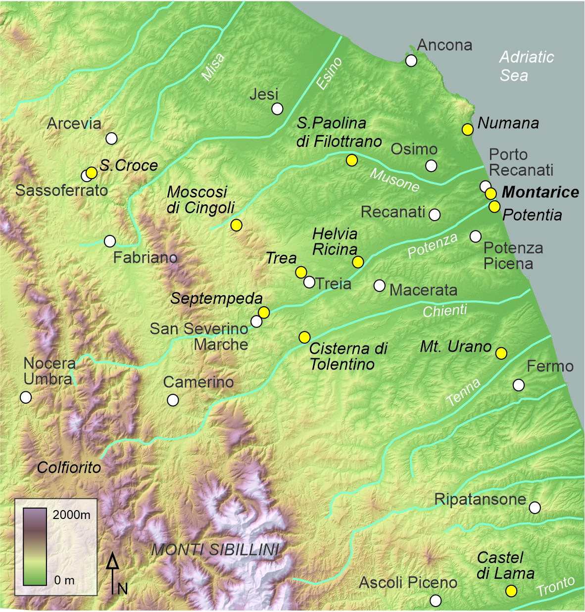
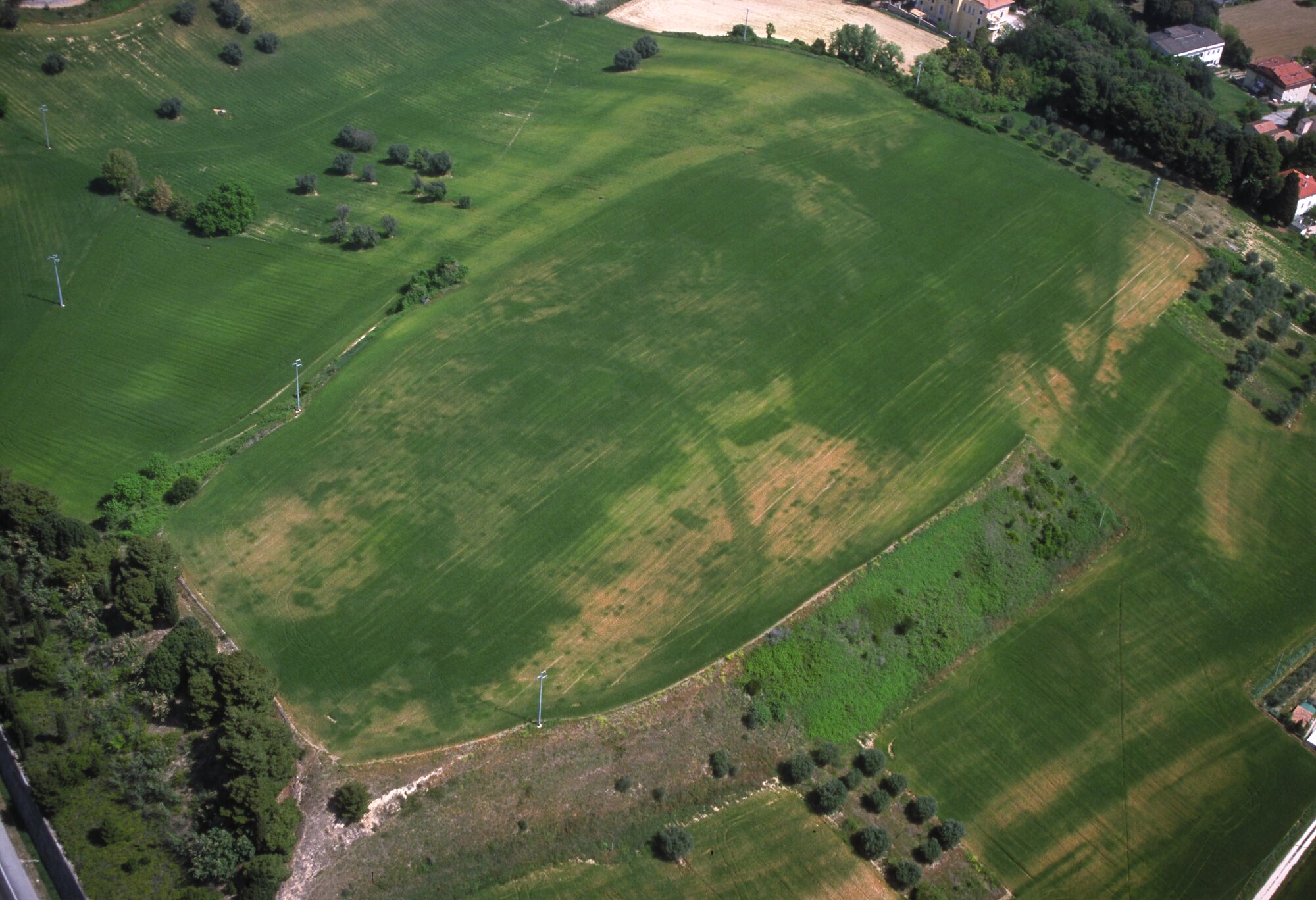
Until today, the low hilltop plateau of Montarice (Figure. 1) is the most intensively studied pre- Roman site in the Potenza Valley Survey (PVS) of Ghent University (Belgium), but the site was known and investigated already in the 1970s. It is atypical in the PVS dataset: it is the only site with long-term (if not continuous) occupation between the Palaeolithic and the Middle Ages, with its zenith in the Bronze Age. Although the PVS had a diachronic approach and recorded remains from all periods, especially in later years the focus of the project gravitated towards the Roman periods and the Romanization processes in the centuries before the Roman conquest. Indeed, the non-invasive approach combining artefact surveys, aerial reconnaissance, and geophysical surveys proved very effective in mapping and analyzing the archaeological record from these phases, for instance in the detailed maps of the Roman towns of Septempeda, Helvia Ricina, and Trea (Vermeulen et al. 2017; see also Vermeulen - De Neef 2024). In later years the Ghent University research focused on the excavations and full mapping of the coastal colony of Potentia and its immediate surroundings. Despite this increasingly Roman focus, Montarice remained a key site in the PVS because of its location in the direct vicinity of Potentia (Figure. 2). As such it provides an ideal context to study the impact of Romanization and the foundation of the colony on indigenous settlement along the Adriatic coast.
The starting point for our current project is the non-invasive work conducted by the PVS and of a recent spin-off project on pre-Roman settlement in the Potenza Valley (Vermeulen et al. 2017; De Neef – Vermeulen 2018). Over the years these produced surface artefact distributions at various resolutions, geophysical data, geoarchaeological information, and aerial imagery that provide a good overview of the site’s internal layout. Our current project unlocks the survey and artefact inventories of the 2002 Montarice surveys which were incorporated in a Dutch-language, unpublished PhD thesis (Boullart 2006) and only partly published in PVS output (Boullart 2003; Percossi et al. 2006; Vermeulen et al. 2017).
The PVS spin-off project ‘Neighbours and Nobles’ started with a re-study of the unpublished protohistoric material from Montarice (De Neef 2017), and from there expanded into a sixyear landscape-archaeological study of Bronze and Iron Age settlement in the Potenza Valley and beyond through non-invasive prospection methods (De Neef - Vermeulen 2018). This included a complete re-survey (2019) of Montarice at a higher resolution to allow a better spatial integration of the surface distributions with the geophysical surveys and aerial imagery. In the course of the spin-off project the legacy data and find material from the first archaeological work at Montarice in the 1970s became available for study. This material of exceptional quality provides important clues on the subsistence economy, crafts, and exchange networks of the protohistoric community living on and around the hilltop.
Fifty years after its discovery and 20 years after the first artefact survey, we thus dispose of multiple datasets of varying resolutions which so far have not been integrated and studied as a whole. This is the task we now set ourselves. In this article we provide an overview of the available sources at our disposal and present the first results of the ongoing material studies of the Bronze Age occupation phases. First, we place Montarice in its landscape setting and discuss the formation processes that shaped the changing environment of the coastal zone (section 3). In section 4 we elaborate on the research history of the site, connecting the Ghent University non-invasive studies with the observations from the 1970s excavations and surface collections by Delia Lollini of the cultural heritage authorities (Soprintendenza Archeologica delle Marche). Then we move on to our current project, presenting our approach to the data processing and integration of the various datasets. The last part of this article presents the first results of the material studies (section 5) and an outlook to future work.
3. Landscape and archaeological setting
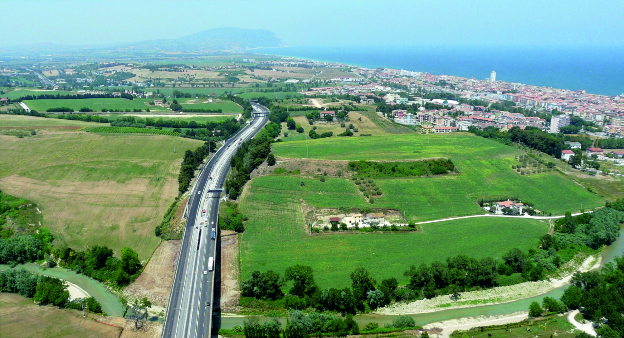
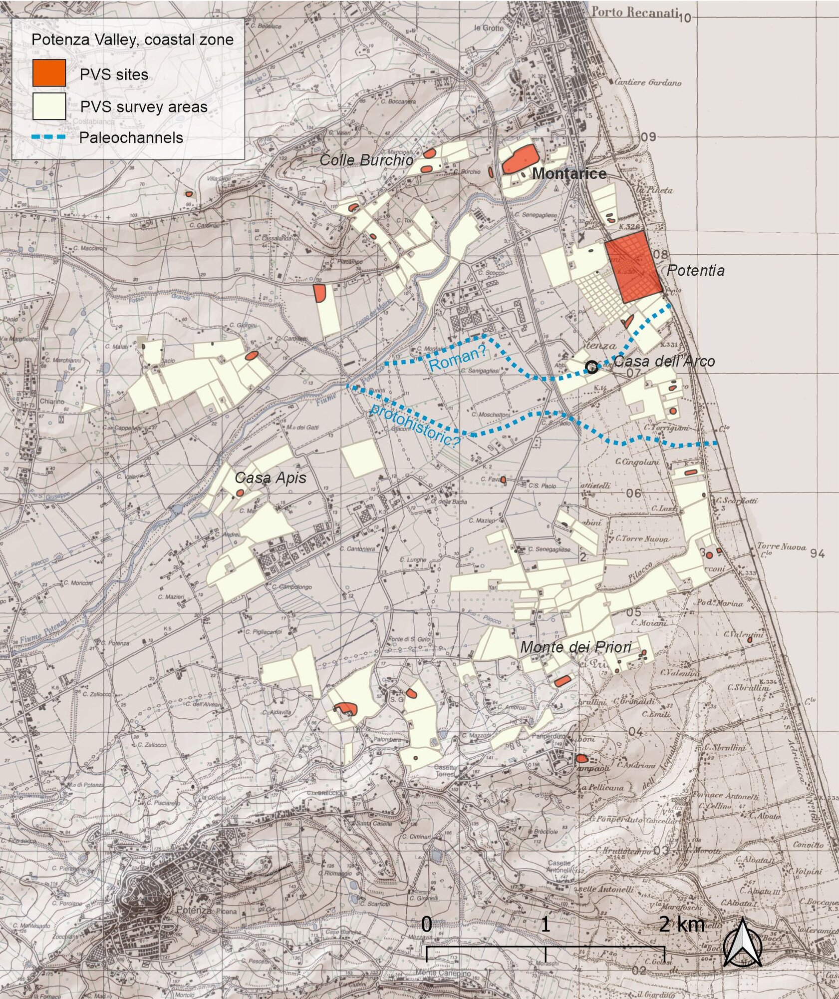
Montarice is a low plateau (ca. 54 m a.s.l.) situated on the outskirts of the present-day town of Porto Recanati (MC, Marche), at a distance of ca. 1 kilometer of the current Adriatic coastline ( Figure. 3). It has relatively steep slopes to the north and south and a gentler descend towards the east. Its western connection to the adjacent Colle Burchio is cut by the Autostrada A14, the construction of which in the 1960s undoubtedly obliterated relevant archaeological evidence. The hill overlooks the coastal zone of river Potenza which runs directly to the south, and has wide views of the broad lower valley towards the opposite hill ridge of Potenza Picena and Monte dei Priori, where another Bronze Age site is located (Vermeulen et al. 2017: 207- 208; Fig. 3). The alluvial coastal plain contains up to 40m of clastic sediments (Calderoni et al. 2007; Centamore 1986; Cilla and Dramis 1999). The remains of former beach ridges, running parallel to the present-day coastline, are buried under alluvial clay deposits. Previous coring campaigns have established the presence of former coastal lagoons behind these beach ridges (see below; Goethals et al. 2009: 432).
Montarice is the easternmost part of a long ridge running towards the town of Recanati. It consists of upper Pliocene to lower Pleistocene blue clays and sandy clays of the Formazione delle Argille Azzurre (FAA) on top of which lower Pleistocene sandy clay, clayey loams and loamy sands of the Formazione di Fermo (FEM) are deposited (Taelman et al. 2017: 49). These dip towards the S-SE as the result of regional uplift. The top of the ridge consists of the remnants of lower Pleistocene marine terraces, with gravel deposits up to 15 m thick (Massari et al. 1986; Goethals et al. 2005: 41). Continuous agricultural activity has impacted on the soils formed in these terraces: only shallow soils are preserved on the highest, western part of Montarice where marine terrace gravels are actively being ploughed out. The ridge ends in an inactive cliff with abrasion platforms at the base (ca. 5-6 m a.s.l.), now in a densely built residential part of Porto Recanati.
The coastal landscape of Montarice has changed drastically during the Pleistocene and Holocene, influenced by natural processes such as climate changes, but also by (indirect) human impact. To understand the environmental setting of the hilltop during various archaeological phases, it is essential to briefly describe the long-term landscape formation processes. The present-day situation is the result of long-term fluvial and coastal aggradation, while the hilltop itself is impacted by agriculture and slope wash. River aggradation characterized the dry and cold Younger Dryas phase of the late Pleistocene, fueled by sediment transport related to slope erosion. The much denser vegetation during the warmer and humid phase of the Early Holocene Climate Optimum (until ca. 6000 BP) decreased the erosion processes and related sediment supply, which in turn resulted in river incision (Calderone et al. 2007; Cilla and Dramis 1999: 78). A climate transition to a colder and drier phase occurred between 6000- 5000 BP and lasted until ca. 3500 BP, covering the period between the Late Neolithic and the Middle Bronze Age. As a result of the decreased vegetation cover in this colder phase, erosion and related river aggradation increased again. Around the same time, ca. 5000 BP, the sea level of the Adriatic reached its maximum (Elmi et al. 1994; Corregiari et al. 1996; Oldfield et al. 2003). The Adriatic coastline during this phase was of the Atlantic type, with steep cliffs alternated by river outlets. During the Chalcolithic and Early Bronze Age (ca. 5000-4000 BP) we may therefore imagine Montarice as a coastal cliff top directly on the coast. During this phase a beach ridge was formed at the river mouth just south of the hill. Geoarchaeological work by the PVS established that the ca. 300 m wide beach ridge is asymmetrical, with a steeper sea-ward slope and a gentler inland slope (Taelman et al. 2017: 57; fig. 36). OSL dates of auger samples place the formation of the beach ridge in the 4th millennium BCE, starting after 5040 ± 35 BP (3953-3713 cal BCE). This date marks the transition from marine sedimentation (heavy clays) to fluvial inputs (sandy loam), explained by a decelerating sea level rise combined with regional uplift (Goethals et al. 2009: 432). The top of the beach ridge was formed between 4.400 ± 500 BP and 3.500 ±400 BP-3.300 ± 500 BP. In 184 BCE the Roman town of Potentia was founded on top of this former beach ridge.
Despite a warmer period in the Middle and Late Bronze Age (ca. 3500-3000 BP), vegetation and forests did not recover but instead dramatically decreased (Giraudi 1998; Taelman et al. 2017: 46). An indirect indication is the lack of new travertine deposits in the Apennine inland during this phase (Cilla et al. 1994). Travertine deposits are a typical phenomenon of the central Adriatic Apennines during the early Holocene climatic optimum, when Mediterranean thermophile forest vegetation and thick brown-calcic soils lead to large amounts of CO2 in the atmosphere. In summary, excess CO2 enters groundwater through precipitation, where it contributes to the dissolution of limestone and subsequently the deposition of travertine around natural springs. This process comes to a halt between 6000-3500 BP, indicating the onset of a colder, drier phase. The decline in travertine deposits in the entire central Adriatic Apennines suggests that this is part of a wider environmental development (Cilla – Dramis 1999: 81; Calderoni et al. 2007). The absence of new travertine formation after 3500 BP, during the Middle and Late Bronze Age, indicates a lack of excess CO2 despite a warmer period favorable for plant growth. Although it is difficult to determine the extent of human impact on these processes, increased exploitation of woodlands and pastures in the Apennines may have been a decisive factor (Cilla et al. 1994). These anthropogenic alterations of the natural environment have been linked directly to vegetation changes and increased erosion in different parts of Italy (Sevink et al. 2019 for southern Italy; Magri – Sadori 1999; Ramrath et al. 2000; Sadori 2018 for the central Tyrrhenian). Similarly, mass sedimentation acceleration starting around 3600 BP is attested in sediment cores taken the central Adriatic, as a result of surface processes related to forest clearance and intensified cultivation in Adriatic Italy (Oldfield et al. 2003). A similar phase occurred in the Middle Ages (starting ca. 700 BP). The related sediment supply from slope processes in turn resulted in renewed alluvial deposits in the valley floors as well as coastal aggradation. This latter process reinforced the formation of beach ridges in front of the coastal cliffs, as well as the gradual transformation of the coastal lagoons behind the beach ridges into marshlands and/or seasonal wetlands. The beach ridges and the wetlands directly behind them will have been an important factor in the accessibility and mobility in the coastal zone during the Bronze Age, and may also have provided landing places for ships. This latter point is not trivial, since the coast of Marche has no natural harbors except for the sheltered bays on the Conero promontory near Ancona and Numana.
The lower course of the river Potenza changed considerably during the Holocene, gradually migrating from the south to the central part of the plain between the Bronze Age and the Middle Ages, and then abruptly to the north (Fig. 3). Currently the river runs between the Roman town Potentia and the foot of Montarice in the northern part of the coastal plain. This course is artificial and was created by cutting an upstream alluvial fan, sometime after 355 ± 30 BP (1453-1635 cal CE; Goethals et al. 2009; Taelman et al. 2017: 62). Older river courses in the southern part of the plain were reconstructed using aerial photography, geomorphological studies, hand augering and electric resistivity surveys. Two main paleochannels can be distinguished in the aerial imagery. The southernmost of these consists of a meandering gravel bed in a 10 m wide transition zone and sandy riverbanks of ca. 20-30 m wide. The top of the gravel bed was OSL-dated 3600 ± 400 BP and thus coincides with the Bronze Age occupation at Montarice and the beach ridge which was formed in the preceding centuries (possible paleochannel labelled ‘protohistoric’ in Fig. 3). The second paleochannel runs directly south of Potentia in the central part of the coastal plain. It is crossed by a Roman bridge which is preserved in the foundations of an 18th century CE farmstead at Casa dell’Arco, and must thus in any case have been present during the Roman occupation of Potentia. This may be the river Flosis which we know from Roman sources. 14C-dates from a core taken near this bridge show that the river remained open until the Middle Ages (top of the gravel bed dated 630 ± 25 BP /1288 - 1397 cal CE) and then started to migrate north (sandy riverbed deposits on top of the gravel bed dated 505 ± 25 BP / 1400-1445 cal CE). Clayey floodplain deposits dated 80 ± 25 BP (1692-1920 cal CE) indicate that the coastal plain was regularly flooded until the late 19th/early 20th century, gradually filling the wetlands behind the protohistoric beach ridge (Goethals et al. 2009: 436). The artificial post-medieval channel is visible in ancient maps, and originally ran through Porto Recanati (Corsi et al. 2009; labelled ‘post-medieval’ in Fig. 3). This major hydrological work is often placed in the context of increased population and land reclamation for agriculture (Cencini and Varani 1991; Nanni and Vivalda 1997; Goethals et al. 2009; Taelman et al. 2017).
Marine sediment data indicate a minor sedimentation peak around 2400 BP, in the later Piceni phase, but this is not related to heavy deforestation as seen in the Middle Bronze Age pollen record (Oldfield et al. 2003). In fact, there seems to be little change in, and direct human impact, on vegetation during the Piceni and Roman periods; an observation which is corroborated by pollen samples from Lago Mezzano in Central-Tyrrhenian Italy (Ramrath et al. 2000). The wetland environment of the Roman town of Potentia is reconstructed from pollen samples taken from stratigraphic contexts of the western gate, excavated by Ghent University between 2007 and 2010 (Taelman et al. 2017: 59). During the late Republican phase, the landscape was open with only limited evidence for deciduous (oak, elm, hornbeam, maple, hazel) and hygrophilous (poplar, willow, alder) trees. There are indications for brackish conditions related to marine ingressions in the presence of halophytic plants. Crop cultivation and horticulture is reflected in the presence of cereal, fruit and vegetable pollen. In the Imperial period, the plant economy changed to denser hygrophilous forest cover paired with an increase in grassland and a decrease in cereals, fruits, and vegetables. The presence of typical wetland herbaceous taxa such as reedmace and reed confirm the presence of the river and permanent water near the city. This open grassland situation with limited crop cultivation and hygrophilous trees continued into the Middle Ages, when a new heavy erosion phase occurs (visible in the marine sediment records).
4. Previous research
4.1 The Lollini excavations and surface collections, 1970s
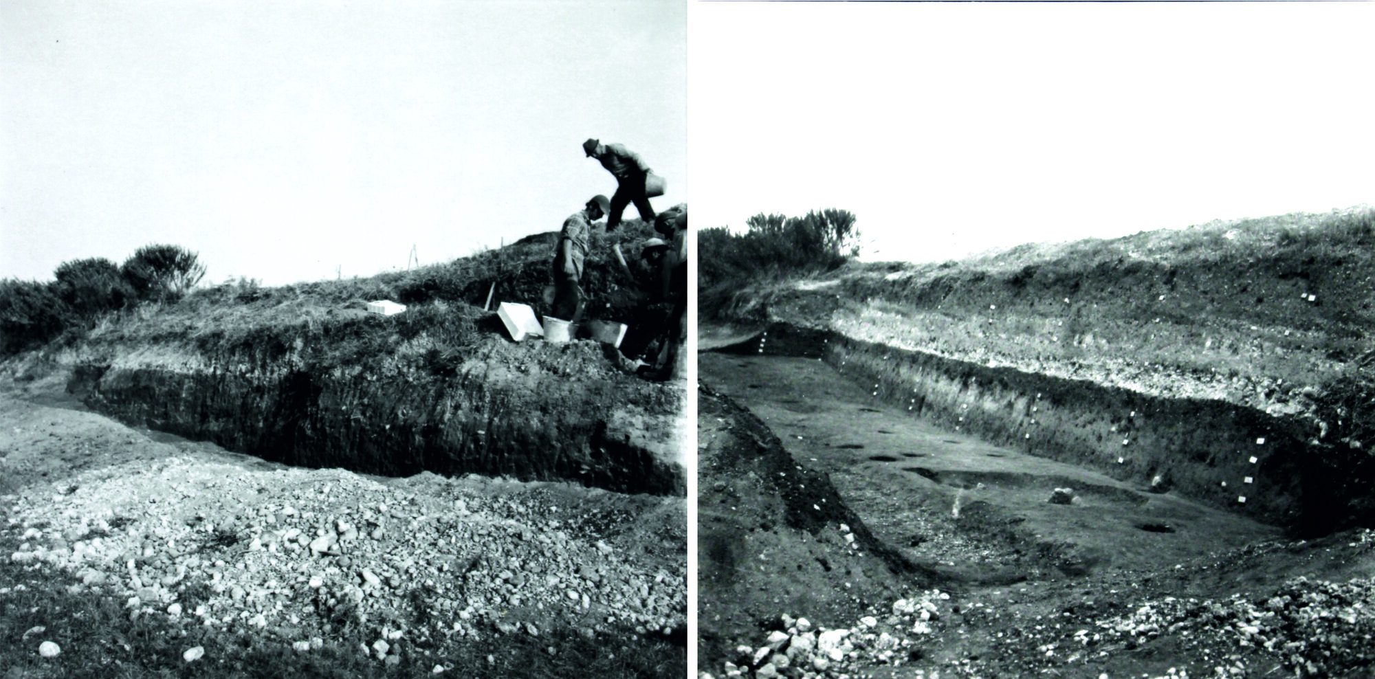
The earliest research of Montarice was conducted in the 1970s. After a first report of archaeological remains by inhabitants of Porto Recanati, the inspector Delia Lollini of the Soprintendenza Archeologica delle Marche visited Montarice in December 1973 to take stock of the situation. In her site report she mentions to have seen lithic artefacts, Roman potsherds and protohistoric pottery with typical Apennine-style decorations along the southern side of the plateau. Of immediate urgency, however, was a recent trench excavated in preparation for construction work on the NW slope. In its sections Lollini observed a dark layer of ca. 80 cm thick and at least 1.50 m wide with abundant prehistoric pottery fragments. She also noted an Upper Palaeolithic pointed scraper on the surface in this area. Alarmed by the planned construction work, Lollini proceeded with a single rescue excavation campaign in October 1977 that helped to impose protective measures and safeguard the site. A strip of 18 m was investigated by cutting back the NW escarpment in spits of ca. 15-20 cm to a total depth of ca. 2 m below the break of slope (Fig. 4, left). Finds were collected for each spit in 2 x 2 m grid units.
Following the cleaning of the lowest level at the base of the escarpment (approximately 2 m below the top of the hill), several pits of varying size were found with diameters up to 35 cm in diameter (Figure. 4, right). These pits were recognizable by their greyish-colored filling compared to the brown color of the layer in which they were cut. The pits contained mainly small ceramic fragments, some with typical Apennine-style geometric decoration (MBA3, late 15th-late 14th century BCE), and some faunal remains. A possible alignment of these pits indicating their use as postholes for structures needs to be verified. There is indeed evidence for the presence of buildings: the finds include fragments of hut loam with twig impressions, also in the lowest levels. During the 1977 campaign, 82 crates of material were collected, which are currently stored at the Museo Archeologico Nazionale delle Marche (Ancona). These contain artefacts from all phases of occupation of the site, from the Palaeolithic to the Middle Ages. The majority of finds are pottery fragments, but there are also lithic artefacts, metal and plaster fragments, and faunal remains.
A few years later, in August 1979, Lollini inspected an area directly downslope from her earlier excavations. These surface inspections took place after ploughing had exposed fresh archaeological material. She collected six more boxes of artefacts in which all the phases of occupation of the site are attested. No invasive work has been conducted at Montarice since the Lollini excavations; the hilltop obtained a protected archaeological status. A first overview of the materials recovered by Lollini is given below in section 5.
4.2 Aerial photography, 2000 – 2014
Between 2000 and 2014 the PVS acquired aerial photographs of Montarice during a series of observer-directed low-altitude flights with a small aircraft above the whole Potenza Valley (Vermeulen 2009; 2011). The early photographs were taken with an analogue 35 mm reflex camera; and from 2004 onwards with digital cameras. An important impulse for the PVS studies at Montarice were successful flights in 2001 and 2003, during which very clear cropmarks indicative of ancient structures were recorded (Vermeulen - Verhoeven 2004: 60, fig. 2; Vermeulen et al. 2005: 49-52; Vermeulen et al. 2017: 79). Subsequently, Montarice was monitored during annual flights until 2014, thus compiling a large dataset of aerial imagery documenting cultivation and soil regimes. From 2007 onwards the PVS experimented with a range of unmanned low-altitude aerial photography devices. The motivation for these experiments came from the wish to acquire both higher-resolution photos to identify smaller features, and imagery in the invisible near-ultraviolet and near-infrared domains. TThe early experiments included flying a Helikite, a 7m3 helium balloon with attached kite wings that could carry a small remotely-controlled camera cradle and which could fly up to 250 m (Van Limbergen et al. 2017: 23; Verhoeven et al. 2009). The Helikite was also used at Montarice to obtain such additional imagery in the visible and invisible domains.
The multiple aerial photographs of Montarice allow to distinguish a range of anthropogenic traces, and to monitor their preservation and visibility across the years. One of the most conspicuous is a large curvilinear feature with positive cropmarks, indicating that this is a deposit with a high organic content (Figure. 5). It delineates the upper, western part of the plateau and is tentatively interpreted as an enclosure ditch. On either side of it are multiple cropmarks, both circular and rectangular. These too have positive signatures indicative of pits and lowered floor levels covered with organic material. The imagery taken in 2005 was of particular high quality and immediately demonstrated the value of aerial photography in the study of Montarice. Additional processing of the imagery was used for a first interpretation of functional zones at the site (Verhoeven et al. 2009). The cropmark features could not be dated by their morphology alone, but the subsequent artefact surveys of the early 2000s and the resurveys in 2019 provided additional chronological clues (see below).
4.3 Fieldwalking surveys, 2002
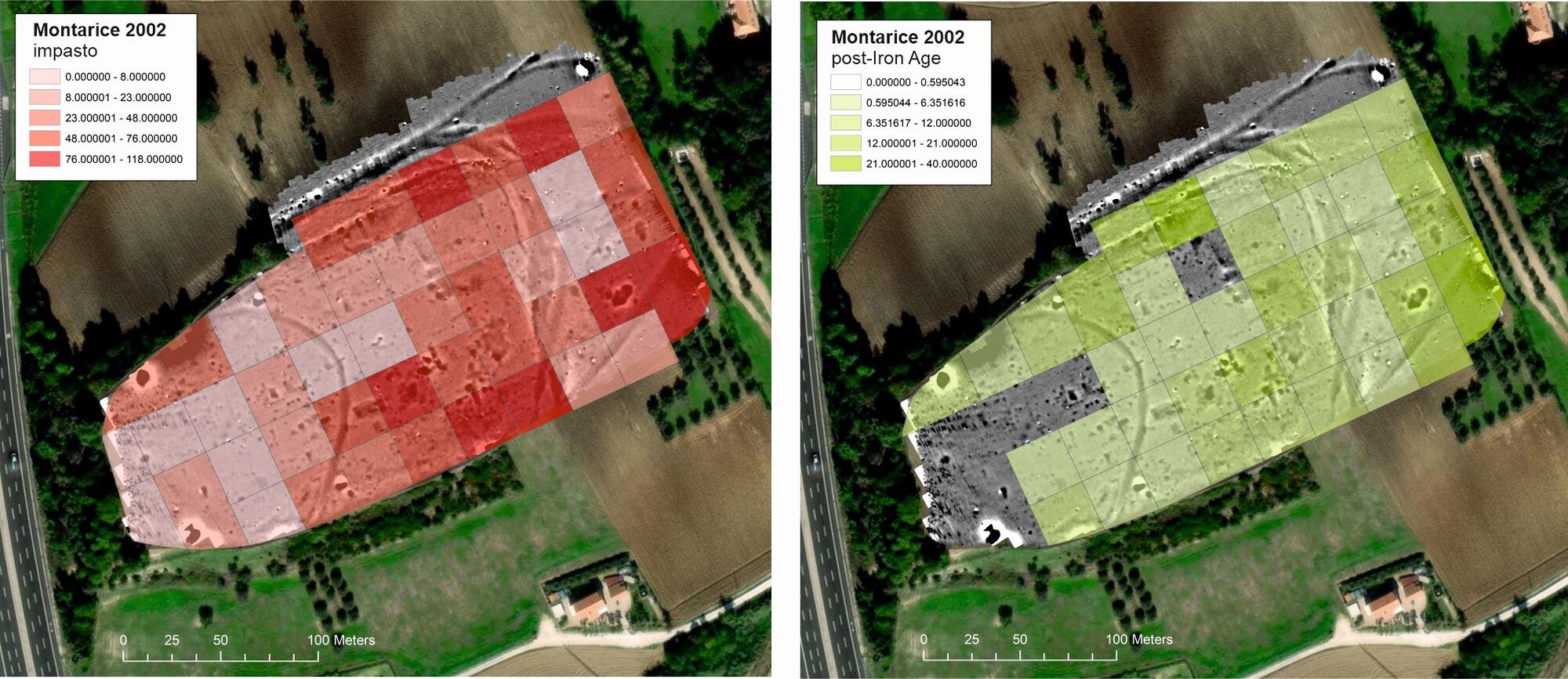
The hilltop is ploughed and cultivated to this day, causing progressive erosion, especially on the higher western part of the plateau. Archaeological artefacts from occupation deposits are therefore continuously mixed in the plough zone. The first systematic surface survey of the site was carried out in 2002, following on the 2001 aerial reconnaissance. The surface artefacts were collected in units of 30 x 30 m on the plateau, and larger units on the slopes (Figure. 6). The artefact distribution confirms Lollini’s earliest observations that protohistoric and later occupation was not limited to the NW escarpment, but also occurred on the top plateau and partly on the southern slope. On the relatively flat top plateau the lateral displacement of artefacts is limited, although the ongoing ploughing will have resulted in the progressive mechanical wear and fragmentation of archaeological objects. Artefacts may have been transported further from their depositional origin on the northern and southern slopes, as indicated by their fragmentation and wear. The deposits from which these artefacts are eroding are still present, as was seen in aerial imagery and later also geophysical data.
Catharina Boullart’s PhD and a preliminary re-study of the 2002 artefact distribution already suggested long-term occupation dynamics at Montarice (Boullart 2006; De Neef 2017), with phases of occasional prehistoric human presence and dense habitation (MBA-RBA) followed by low-density presence or perhaps even complete abandonment (Final Bronze Age-Early Iron Age), re-occupation (Picene Iron Age), and low-density presence again (Roman and medieval periods). The close study and publication of the PVS survey materials of Montarice are part of our current project, aiming at a higher resolution of chronological and functional detail. However, the main challenge of the 2002 materials is the low spatial resolution of the survey, which prevents us from making direct links with the results of the aerial and geophysical surveys (sections 4.2 and 4.4).
4.4 Geophysical prospection and coring, 2013
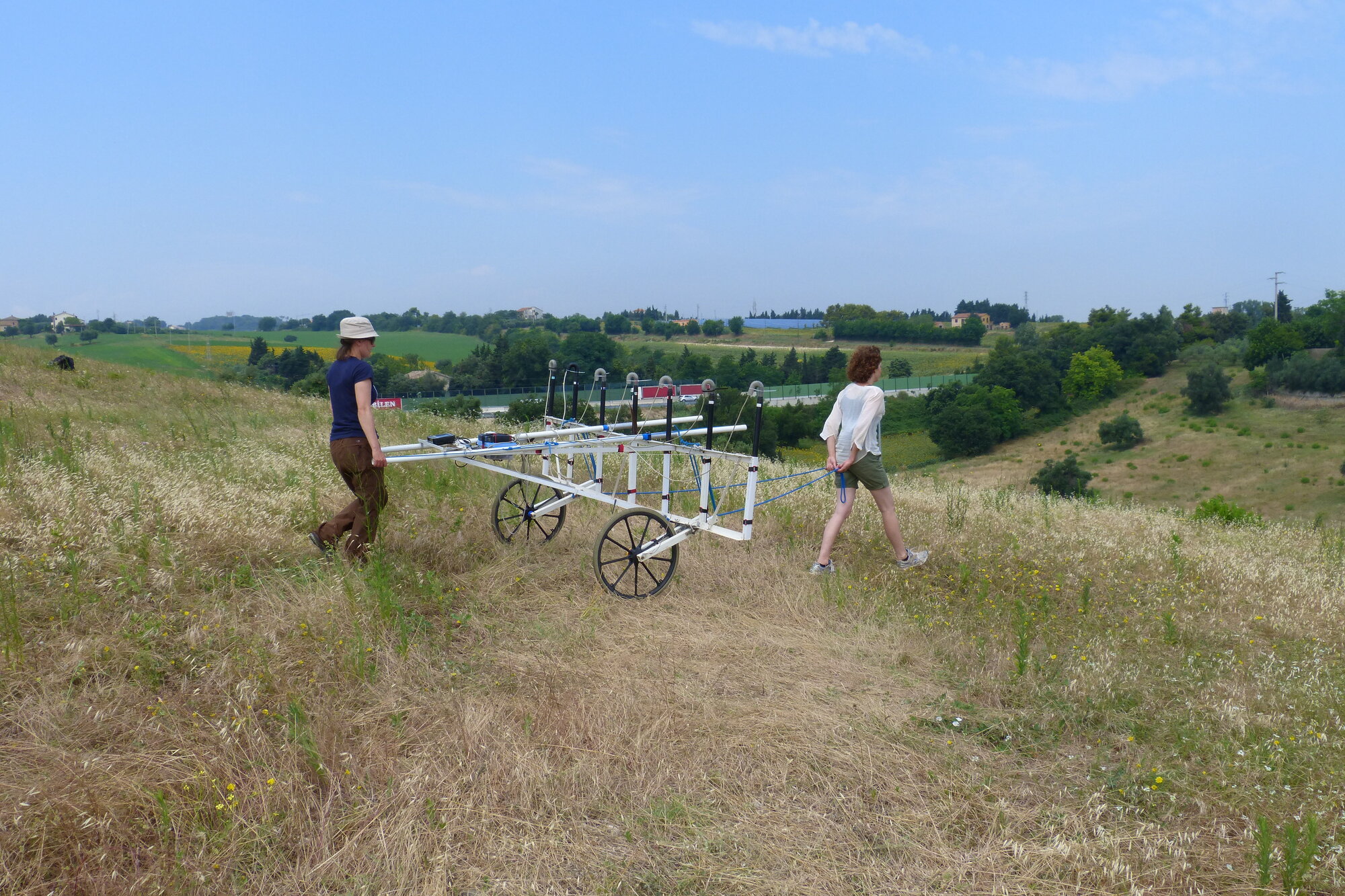
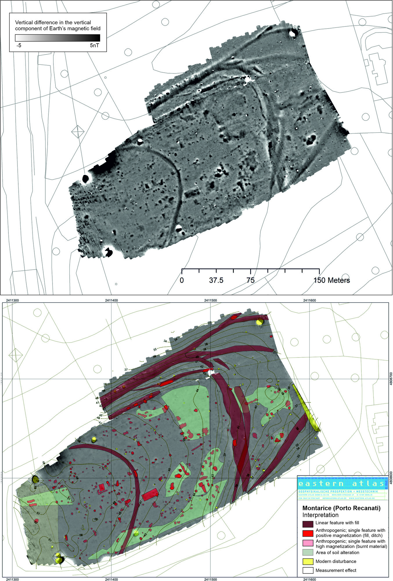
In July and October 2013, a magnetometer survey was conducted on the Montarice plateau and parts of its upper slopes (Vermeulen et al. 2017). A flexible cart array with seven Foerster FEREX 4.032 CON 650 fluxgate sensors was used to map the plateau and part of the north slope (Figure. 7). The results of the magnetometer survey are striking: apart from isolated disturbances caused by electricity poles at the plateau edges, the data reveal a large number of archaeologically relevant traces that seem to be little affected by later impact (Fig. 8). One of the most conspicuous magnetic features corresponds to the large semi-circular cropmark seen in the aerial imagery. It is ca. 4-5 m wide and has weakly positive magnetic amplitudes. The magnetic signature, size, and location of this anomaly underline the earlier interpretation of the cropmark feature as a large ditch that delimitates the upper zone of the plateau. In recent publications on the Montarice magnetometry, we explored possible approaches to estimate the labor effort needed for the construction of such large ditches, using an architectural energetics approach based on the geophysical properties of the anomaly (width, length, estimated depth based on magnetic amplitude; De Neef - Ullrich 2019; De Neef 2023).
We interpret single magnetic anomalies on both sides of the large curvilinear feature as traces of human occupation (Figure. 8, bottom). They include (semi-) rectangular features that may be traces of buildings, pit-like circular anomalies and clusters of traces that indicate activity zones. It is difficult to establish whether these traces belong to single or multiple occupation phases. The magnetometry dataset shows that the plateau was nearly completely occupied, in discrete clusters, although their contemporaneity is unclear. In 2019 a full high-resolution artefact re-survey of the entire plateau was conducted to collect more detailed information of occupation clusters and their temporal variation in relation to the geophysical features (see section 4.5 below).
A striking set of large curvilinear traces in the northern and eastern parts of the plateau were initially also interpreted as large man-made structures possibly related to demarcation and/ or defense of the site (Fig. 8, bottom). However, their morphologies and magnetic signatures were different from the semi-circular features that we interpreted as a ditch: all of them have weak dipole characteristics. The results of an electrical resistivity tomography profile laid out across one of them showed that this indeed is not a ditch, but an outcropping conglomerate bank causing a significant magnetic contrast with the overlying and surrounding soils. This was confirmed by targeted coring. Still, such natural phenomena may have been intentionally incorporated in the site’s architecture.
4.5 Re-surveys, 2019
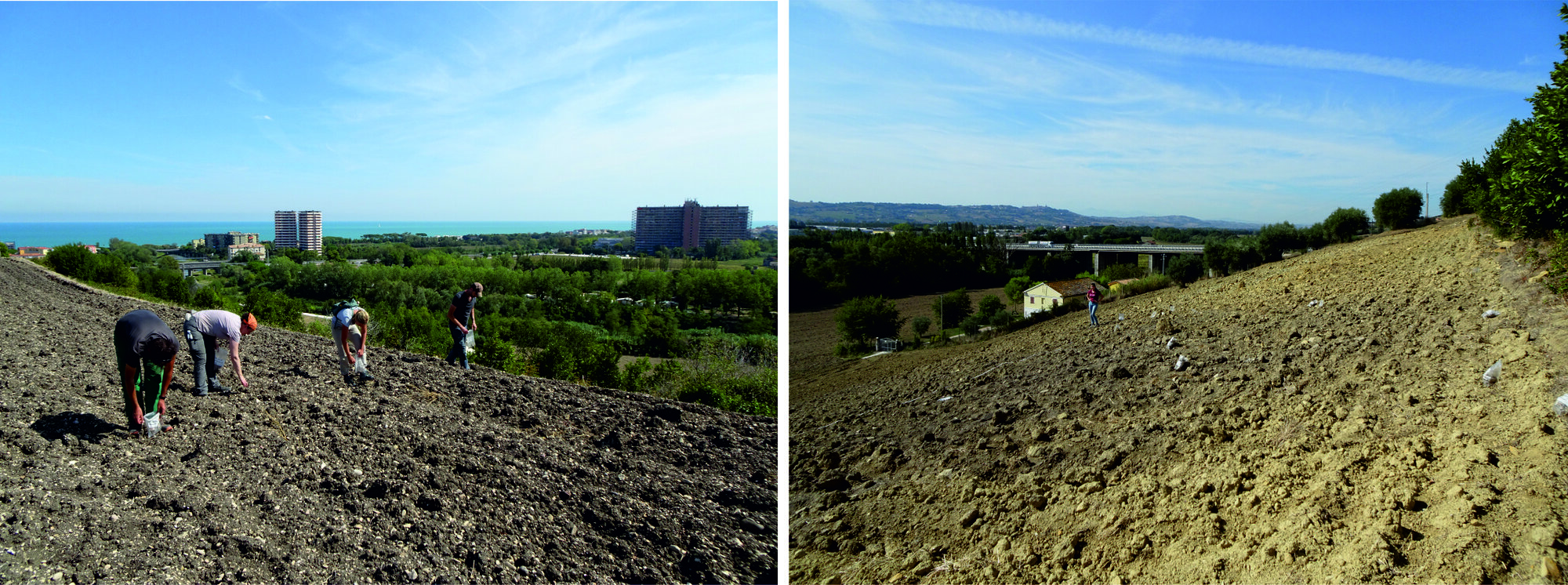
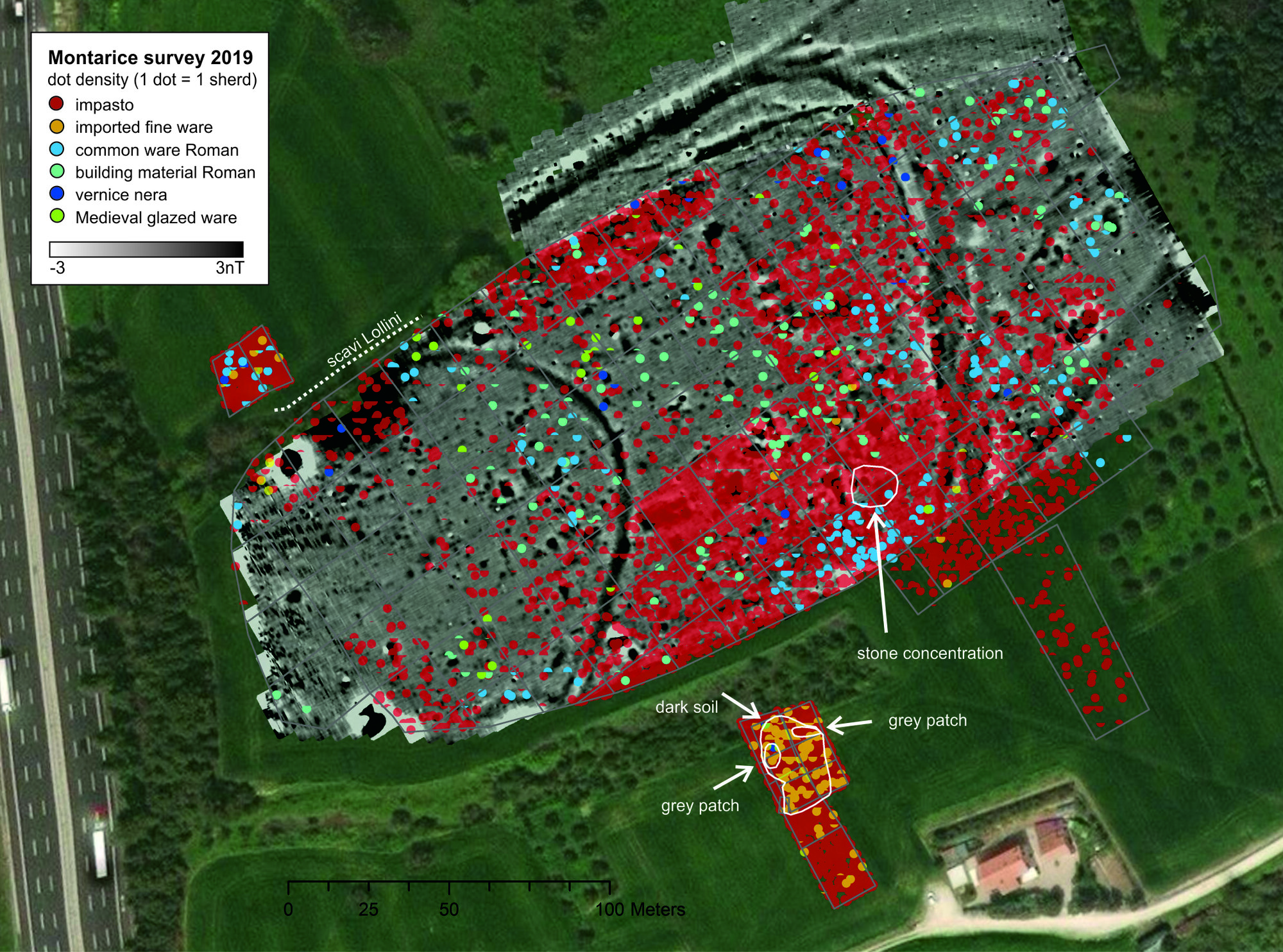
A complete re-survey of the plateau and parts of the north and south slope was conducted after ploughing in September 2019 (Figure. 9). Aim of the survey was to obtain an artefact distribution map at a higher resolution than the 2002 one, to establish spatial associations between the surface record and the subsurface features identified in the magnetometer data (Figure. 10). The survey was conducted in 20x20 m units. Walkers typically walked at 5 m interval (surface coverage 40%), but collection was intensified if a concentration of material was encountered (total sample, 100%). All materials were collected per unit except for bulky building materials (cobbles, tiles, etc), which were recorded but left in the field. Special finds and remarkable surface features, such as a cobble concentration, were recorded by GPS. Some artefact concentrations can be related to magnetic features, but further research (coring, test pitting) is needed to confirm the spatial and chronological associations.
We also investigated two areas of interest on the slopes of the plateau. On the southern slope a circular feature had been observed in aerial photos (Verhoeven et al. 2017); we suspected that this may be an eroding funerary monument (Fig. 9, right). On the north slope, a dark patch of soil in the vicinity of Lollini’s 1977 excavation was investigated.
The feature on the southern slope was first investigated in three 15 x 20 m units (4001-4003), with 3 walkers walking at 5 m interval. The quality and density of material was so high that we subsequently intensified the artefact collection: the area with the most finds was surveyed in 6 units of 10 x 10 m at 100% coverage (units 4004-4009). Two grey patches at the western border of the artefact concentration were investigated separately as we suspected they may be related to discrete ash deposits (units 4010-4011). The extent of colored patches of soil were recorded by GPS.
The circular feature seems to be related to a funerary context, considering the number of fine wares including a miniature impasto pot. The extent of the material concentration matches the circular feature seen in the aerial imagery. Two occupation phases can be distinguished: a Bronze Age phase with materials dating to the MBA3-RBA; and an Iron Age Piceni phase with fine wares (Attic imports, Italo-geometric wares) and bucchero pottery. Storage and coarse wares, animal bone, shells, and building material were also collected. Pending further study of the assemblages and invasive research, we think it is likely that an older Bronze Age (habitation) phase was covered by an Orientalizing Piceni burial.
Of special interest are the artefacts collected in unit 4005. Here a miniature impasto pot, a ceramic and a stone loom weight and a fragment of a bowl were collected, painted import wares, a fragment of an oven floor, pieces of burnt hut loam and a pebble floor. The cemented pebble floor may be part of the Piceni burial. There were no metal finds but the location may already have been searched by metal detectorists.
The brown patch on the northern slope was investigated in two 10 x 20 m units, with walkers walking at 5 m interval (coverage 40%). The abundance of pottery indicates that the brown patch is related to an eroding protohistoric occupation area. Most pottery consists of plain medium- and thick-walled impasto pottery, but there are also a few fragments of (painted) fine ware. This is in line with the finds done by Lollini in this area in 1977 and 1979.
4.6 Current studies
The aim of our current research is to reconstruct Montarice’s occupation history by piecing together the various invasive and non-invasive datasets collected over the years. The greatest challenge is the recovery and translation of unpublished legacy data, establishing the exact locations of surface collections and excavation pits from the 1970s, and their spatial integration with the more recent investigations. As we will show below, the unpublished but well-preserved excavation materials provide us with two crucial pieces of the puzzle which are difficult to extract from the ploughed and weathered surface materials: first, a high chronological resolution, and second, technological and functional information that allows us to place Montarice in wider (supra-)regional socio-cultural frameworks during the Bronze Age. Moreover, they provide us with faunal remains and sensitive materials such as bone and bronze.
Regarding the issue of reflexive data handling (section 1) in the integration of analogue (excavation documentation), digitized (fieldwalking distribution maps, aerial imagery and terrain models, geoarchaeological observations), and natively digital datasets (geophysics), we were confronted with the problem of transforming the 1970s information into something we could use to our purposes. This implied that we had to create new metadata for our translations of Lollini’s poorly legible diaries, drawings, and photographs, starting from the information we hoped to extract. First of all, we aimed at a degree of certainty about the positioning of the trenches. This was especially of interest for a small trench on the top plateau visible in one of the photographs, which we hoped to associate with cropmarks or magnetometry features as a degree for the site’s preservation or degradation. This proved to be impossible due to the limited dimensions of the trench, but also the inherent ambiguity in the interpretation of the non-invasive prospection data. Another issue was establishing the selection criteria for the find materials in three categories: ‘selected’ (scelto), ‘also selected’ (anche scelto), and ‘not selected’. This was important to determine which excavation spits are securely dated to the Bronze Age, and thus suitable for the zooarchaeological study and the selection of bone samples for the isotopic analysis. Although Lollini’s diary is not outspoken on this topic, the large amounts of non-diagnostic wall fragments (the ‘not selected’ category) suggest that most material was taken. However, while counting and documenting the unwashed finds in these crates, we realized that Lollini had not been all too selective: there were many natural stones that had apparently been mistaken for pottery. Ultimately, we realized that the quality of her ‘selected’ and ‘also selected’ finds groups are the key to integration with the finds repertoire from the field surveys in the 2000s. Lollini’s finds provide us with a narrow chronological framework for the protohistoric occupation and later phases, but also about pottery production and (supra-)regional contacts. Moreover, the 1970s surface and near-surface finds give us a baseline for the preservation of archaeological deposits at and near the ploughzone. The pottery fragmentation rates in the surface collections of the 2000s and 2019 illustrate the progressive degradation of the site.
Preliminary analysis of the diagnostic finds of the 1977 Lollini excavations (2800 fragments) shows that 92% can be dated to the Bronze Age, in specific to the last phase of the Middle Bronze Age (MBA3; late 15th-late 14th century BCE) and, to a lesser extent, to the Recent Bronze Age (RBA, c. late 14th-mid 12th century BCE). Materials from these two Bronze Age phases are present in all the investigated levels, but become exclusive in the lowest levels of the excavation spits (VII to X). These levels do not yield any historic pottery. To date, diagnostic material from the different phases has been selected and photographed, and drawing is in progress. The faunal finds from the lowest levels, VII-X, are the subject of archaeozoological investigations for the determination of attested species and the selection of samples for isotopic analyses aimed at the study of animal mobility in the Bronze Age 1. The material collected on the surface in 1979 is also being studied, while the analysis of the finds collected during the Potenza Valley Surveys in 2001 and 2002 and during the 2019 reconnaissance has almost been completed.
In the next section, we present the first results of the ceramic studies of the Bronze Age materials from the Lollini excavations and the PVS surveys.
5. The main occupation phases of Montarice: MBA and RBA
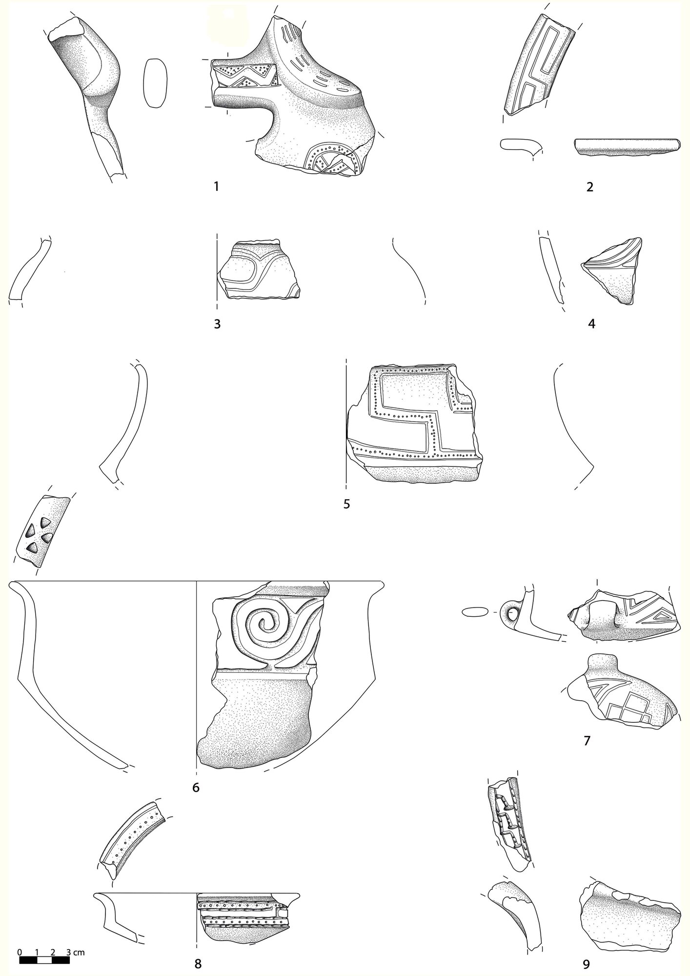
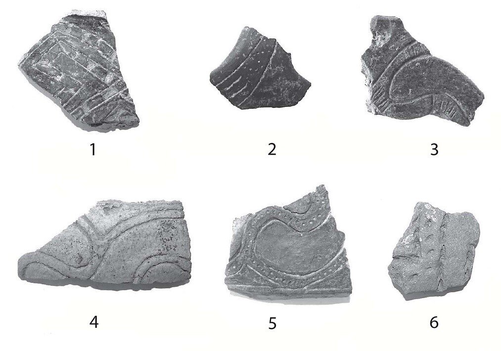
Most of the material found at Montarice consists of Bronze Age pottery and, specifically, of the so-called Apennine facies (MBA3, late 15th-late 14th century BC) and, to a lesser extent, to the Sub-Apennine facies (RBA, late 14th-mid 12th century BC). To date all decorated fragments of the Apennine facies from the 1977 excavation and the surveys carried out since the 2000s have been photographed and, in part, drawn. Drawings are made of fragments with legible decorations, or where at least a distinction can be made between angular and curvilinear motifs. The fragments with such Apennine decorations amount to 576, the total number of recorded decoration motifs is higher (640 decorations) as it is quite common that several parts of the same vase are decorated with different decorations (usually the inner part of the rim and the upper and lower walls).
Pottery datable to the RBA phase is abundant, but less than the MBA3 material. The finds from this phase are characterized above all by the presence of upstanding handles with cylindrical ends (cilindro-rette), or with zoomorphic elements such as horns and bird-shaped protome. These typical RBA elements are, unfortunately, always found without the vessel on which they were originally set (generally open forms such as bowls and cups). The documentation of the RBA material is still in progress.
5.1 The decorated pottery of the Apennine facies (MBA3)
Here we present the very first results from the study of the Apennine phase sherds, which were part of a recently concluded PhD project at Sapienza University of Rome (Paolini 2023). The most characteristic element of the Apennine facies is a particularly rich apparatus of geometric decorations, mostly realized through incision, impression and carving. This is the first aspect of Italian Bronze Age material culture distributed over a wide area, between Romagna and northern Apulia and, on the Tyrrhenian side, between central Tuscany and northern Calabria. Regional peculiarities are present both in terms of the decorations (Macchiarola 1987: 151- 157, fig. 69) and the pottery shapes (Poggiani Keller 1995: 359; Macchiarola 1995: 441-457, tab. 2). However, there exists an underlying homogeneity that indicates a broad sharing of morphological and decorative models between the different communities of the peninsula.
At Montarice, the typical angular and curvilinear decorations are present, both without backgrounds (henceforth ‘smooth’) and filled with impressed dots and incised hatches (‘fillers’). Montarice is part of Macchiarola’s ‘Middle Adriatic group’, which has a high number of exclusive decorative motifs (Macchiarola 1987: 151-152, Figs 69-70) that are also attested on our site.
An analysis of the relationship between the vessels’ shape and the decorations shows that open forms with an articulated profile have the most decorations at Montarice (97% of recognizable shapes). Carinated cups and bowls are by far the most decorated (77%) compared to the cups and bowls with a rounded profile (27%). On closed forms decoration is only present on neck vases (vasi a collo). There are also numerous fragments of decorated grip elements, such as handles and knobs, most of which can be associated with open forms.
Seventy percent of the decorations are made with the incision technique; in 15% of the cases combined with the technique of impression. Carving is present on 7% of the sherds and is mostly used to outline opposing rows of triangular elements on the inner surface of rims and, to a lesser extent, for lines in angular or curvilinear motifs. Of particular interest is the presence of wide and deep incisions and another technique that produces an effect similar to a wheel profile, the so-called ‘roller’ technique (a rotella: Baldelli et al. 2005: 555. Lucentini 2005: 608; Figs 11.8-9, 12.6). This technique occurs mostly in Adriatic Italy. In Marche, this technique is also known from the sites of Castel di Lama (AP; Lucentini 2005, fig. 5. 1-3, 5), San Giovanni di Monte Urano (FM; Baldelli, Damiani 2005, fig. 1. 2-3), Cisterna di Tolentino (MC; Percossi, Pignocchi, Sabbatini 2005, fig. 1.16), Campeté (MC)2, Santa Paolina di Filottrano (AN; Rellini 1932, tab. III.1–2), and Pieve Torina (MC; Rellini 1932, fig. 28).
The decorative motifs at Montarice are mostly without filling elements such as dots or lines (70% of the fragments). Dense dots (3%) are scarce compared to the single row of dots (16%), such as, for example, in the materials from Santa Paolina di Filottrano (AN; Rellini 1932; Macchiarola 1987) and Monte Santa Croce di Sassoferrato (Lollini 1957). Hatching is well documented (9%), especially in the version in which vertical or horizontal strokes are grouped together and separated by free spaces (Figs 11.1, 12.2-3). Two rare types of fillers have been identified at Montarice: the undulating row of dots (Fig. 12.2) and the row of carved squares alternating with free spaces (Fig. 12.1). The former is found on a significant number of fragments in the Abruzzo site of Coccioli (TE; Macchiarola 1987, e.g. tab. 18.3) and probably on a fragment from Monte Ingino (PG)3. The second type is mostly associated with ribbons or straight bands, while it rarely occurs with curvilinear motifs such as spirals. Beyond Montarice, curvilinear figures filled by carved squares are found in a few other contexts, all located on the Adriatic side of the Italian peninsula: Santa Paolina di Filottrano (AN; Rellini 1932, tab. II.3), Castel Trosino (AP; Polletti 2000, fig. 21) and Grotta a Male (AQ; Pannuti 1969, figg. 11.6; 14.4).
Curvilinear decorative motifs are the most frequently attested at Montarice (55% of the studied decorations). Dominant is the spiral motif made with a linear incision or with a ribbon without fillers (Macchiarola 1987, fig. 7. 25, 29a; Figure. 11.4), followed by the incised ‘running dogs’ (cani correnti) motif, which are also mostly smooth (Figs 11.3, 12.4) or filled with a single row of dots (Fig. 12.5) (Macchiarola 1987, fig. 9. 44a–b). Among the angular motifs, meandering motifs predominate. Frequent is the continuous straight meander motif, made by incision and without fillers (Macchiarola 1987, fig. 10. 56, 57; Fig. 11.2) and, above all, the ‘inverted z’ motif (zeta rovesciata), also made by incision, with the z-shaped elements linked and smooth. Less well attested is the version with the z-shaped elements divided by a row of dots (Fig. 11.5) (Macchiarola 1987, fig. 11. 78, 80b).
Macchiarola (1987) and Baldelli et alii (2005) proposed a distinction between an earlier and a later phase of the MBA3 on the basis of the geometric decorations. Decorations from Montarice belong to both of these sub-phases. To the early sub-phase belong the filling-free motifs with concatenated lozenges (Baldelli et al. 2005, fig. 6.13 bis; Macchiarola 1987, fig. 27.125), concentric lozenges (Baldelli et al. 2005, fig. 6.16; Macchiarola 1987, fig. 28.151) and crosses with concave arms (Baldelli et al. 2005, fig. 6.17 Macchiarola 1987, fig. 24.15a) (Fig. 11.7, bottom). To the late sub-phase belongs the technique that produces a ‘wheel’ effect. At Montarice this is used to create ‘inverted Z’ motifs, with the Z-shaped elements concatenated and without fillers (Fig. 11.9); simple rectilinear ribbons arranged in several registers, often decorating the inner surface of the edges; curvilinear figures, most probably spirals. Other elements that can be dated to the later period are the opposing ‘v-figures’ without fillers4; the oblique false meander motif with carved triangular elements in the resulting spaces5; and, finally, carved spiral motifs6 (Fig. 11.6).
Although both sub-phases of MBA3 are attested, the more recent one seems to dominate. This chronological detail is an important preliminary result of our present studies, which was obtained mainly thanks to the availability of the numerous and better-preserved materials from the Lollini excavation. Further study on the associations between decoration and pottery shape will allow to verify the chronological considerations outlined above. Furthermore, comparisons with other Apennine contexts in central and southern Italy are expected to place Montarice within Bronze Age networks of contact and exchange. For now, we can place our site in a wider regional network where specific decoration motifs and techniques were shared. In our current project, the integration of the legacy data with more recent survey data and the detailed study of the pottery thus allows us to reconstruct a more detailed and complete chronological and cultural framework.
6. Reconstructing the long-term occupation of Montarice
The long research history of Montarice poses specific challenges for the study and interpretation of its archaeological context. We have very useful non-invasive prospection data from aerial imagery and magnetometry, yet these are difficult to associate spatially and chronologically with the artefact distributions from the relatively low resolution early PVS surveys. The 2019 re-surveys added the required spatial detail, but were affected by the progressive fragmentation and erosion of the archaeological topsoil record by intensive agriculture. As a result, we can map the distributions of broad material categories such as protohistoric impasto pottery, Roman common wares, and building materials, but we lack the chronological detail to distinguish shorter-term changes in occupation.
Here the newly accessible documentation and finds from unpublished legacy excavations provide a crucial key. The close inspection of the materials from the 1970s excavations confirm that the main occupation occurred in the final phase of the MBA3 and the early phase of the RBA, a period of ca. 200 years. In the Final Bronze Age and Early Iron Age, Montarice seems to be abandoned almost completely, coinciding with a wider trend in Marche and the Adriatic which is often associated with a radical change in social, economic, and political structures (Baldelli et al. 2005; De Neef 2017). In the subsequent Piceni and Roman phases, the plateau seems to be occupied at a lower density centred on single habitation foci. One of these Roman foci could successfully be associated with a geophysical anomaly through the high-resolution 2019 surveys, while the majority of geophysical features is situated within the general protohistoric impasto carpet. The combined surface collections thus suggest that most of the aerial and geophysical features belong to the MBA3-early RBA window.
This relatively short period falls at the end of a relatively cold period during which the beach ridges formed at the mouth of river Potenza (see section 3 above), making the previous Atlantic-type coastline more accessible and perhaps even allowing for the first time the beach landing of ships. The landscape processes allowing this new coastal connectivity can therefore be linked to the intensive Bronze Age occupation of the hilltop. This is not an isolated case: Montarice’s twin site Monte dei Priori, overlooking the southern part of the Potenza delta, dates to the same period, although it was not as densely settled. The Bronze Age colonization of the coastal zone also coincides with the period of intense deforestation and erosion as reconstructed by the offshore Adriatic sediment columns and peninsular pollen records (see section 3 above). We can tentatively associate this with demographic growth and an increased pressure on the landscape to sustain larger populations.
The maritime connections continue after a period of near-abandonment at the end of the Bronze Age and beginning of the Iron Age. The Piceni Iron Age inhabitants of Montarice had access to Greek fine wares, which we find both on the plateau, in the circular feature on the south slope, and in the excavated levels on the north slope. Whether the Piceni community controlled the import of these wares themselves, through a harbour in the Potenza delta, or whether they obtained them from another trade node such as Numana, is still to be resolved.
At the same time, our new material studies underline the peninsular connections of the protohistoric community at Montarice. During the MBA3 they knew and used the same decorative techniques and motifs attested in contemporary sites in central and southern Italy, combined with some specific aspects that are characteristic exclusively of (central-) Adriatic contexts. Interestingly, in the RBA we also have indications for ‘hybrid’ pottery forms that combine elements from the Adriatic groups with those in the Po basin, which suggest more long-distance connections. These peninsular networks also provide a supra-regional framework for the ebb-and-flow dynamics of protohistoric occupation at Montarice. The abandonment during the Final Bronze Age mirrors a period of profound social, economic, and political change in the Po basin, the Adriatic, and in the wider Mediterranean.
We still have little guidance on the transition from the Bronze Age to the Iron Age, resulting in a chronological gap of ca. 300 years. Montarice seems to have been almost completely abandoned during this period, but possibly this is also an effect of the poor visibility of Early Iron Age shapes and fabrics in the survey pottery. Yet this fits a wider peninsular phenomenon of radical social upheaval and a move into the mountainous inland after the collapse of the coastal network and the Terramare system in the Po basin (Cardarelli 2009).
Similar to other sites in the Potenza valley such as Monte Franco (De Neef 2020), Montarice is reoccupied in the Piceni period, albeit at a seemingly much lower intensity than during the Bronze Age. Both the 1977 Lollini excavations and the PVS surveys show high-quality material from this period, but other than that we have little evidence of an intensively inhabited permanent settlement. The circular traces on the south slope seem to belong to an isolated Piceni tomb that reoccupied an older MBA-RBA context; the pottery from the excavations on the north slopes stem from mixed stratigraphic contexts that indicate that they rolled off the summit plateau. This, in turn, is consistent with the present archaeological record of the Marche: still few Piceni habitation contexts are known and investigated, let alone using geophysical methods. We therefore still have little indications for what a Piceni settlement would look like in a magnetometer dataset. Moreover, it may be possible that a small Piceni settlement on the highest part of the plateau is completely destroyed by ploughing.
The Roman conquest had profound effects on the social, political, economic, and settlement structure in the Potenza delta, but apparently little impact on vegetation regimes and erosion susceptibility. The colony of Potentia on the former beach ridge led to urban development in the alluvial plain. At the same time, Montarice remained inhabited on a very limited scale. With the 2019 survey, we were able to identify one of these small-scale habitation foci, and connect it with traces from the aerial imagery and geophysical surveys. It is interesting to note that the offshore sediment cores indicate a low peak in sedimentation at the end of the Piceni period and shortly before the Roman conquest, around 2400 BP (Oldfield et al 2003; section 3 above). However, this peak is not linked to a substantial change in vegetation, which suggests that agricultural strategies and cultivation intensity in Adriatic Italy did not vary much between the Piceni and Roman periods. Such changes occurred only much later, around 700 BP, possibly linked to increased coastal activity. The post-medieval artificial redirection of the river may only have become possible, and perhaps necessary, by the progressive aggradation of the coastline in conjunction with medieval erosion processes.
7. Conclusions and outlook
Montarice is a textbook case of successful non-invasive studies on a multi-period settlement site, yet there are several challenges to the integration and interpretation of the resulting datasets. The primary challenge is to establish spatial, chronological, and functional associations between geophysical and aerial traces, and the archaeological surface record. A re-study of the 2002 survey materials combined with a high-resolution re-survey in 2019 resolved some of the spatial links and identified small-scale single-period activity foci that remained under the radar in 2002. However, while the spatial resolution of the 2019 survey is high, its chronological resolution is limited: due to the progressive degradation of materials in the ploughzone, the artefacts collected in 2019 have much fewer diagnostic features than the 2002 surveys. We have worked around this using the newly available finds from the 1977 excavation as a chronological baseline, at least for the protohistoric phase. These stratigraphic finds inform us about the pottery fabrics and shapes used at Montarice, and give us a narrower chronological arc for the main Bronze Age occupation phase. In the next phase of our project, we plan a systematic study of the impasto fabrics, aiming to discover further spatial, functional, and chronological trends in the protohistoric settlement. Together with a detailed analysis of the 1977 excavation, these new material studies will be the basis for a volume dedicated to Bronze Age Montarice (De Neef & Paolini in prep.).
A second, related challenge is to unravel the long-term occupation dynamics of Montarice using the ploughzone assemblages. While the excavation provides guidance for further classification of the protohistoric impasto carpet, the materials from other periods are more generic and provide fewer dating clues. Here, too, the advanced mechanical wear of the ploughzone materials is hampering the identification of pottery types with abraded surface treatments (e.g., vernice nera) or painted decorations (Italo-geometric wares, Attic imports). As such, low-density occupation phases remain difficult to grasp, including the Bronze Age- Iron Age transition, the Piceni phases, and the post-antique period. However, the circular feature on the south slope provided well-preserved, datable Piceni materials that entered the ploughzone as recent as 2019 or shortly before. Monitoring the site and keeping an eye on possible newly exposed archaeological deposits is therefore imperative to advance our understanding of the material record, especially of the lesser-known phases. For the Roman phases, we dispose of a high-resolution comparative dataset: the excavation materials from the Ghent excavations at Potentia. The studies of the Roman materials from Montarice using the Potentia parallels are ongoing by Anna Gamberini and Emanuela Grassetti, and will be included in an upcoming volume about settlement development in the Potenza delta between the Bronze Age and the Roman period (Vermeulen - De Neef (eds.), in prep.).
Looking beyond Montarice, we realize the unique character of our site. Despite the many open questions, the amount and quality of information on the spatial organization and material culture is exceptional and has few parallels in other long-term and/or pre-Roman sites in Adriatic Italy. Placing Montarice in a wider cultural, historical, and environmental context requires more (non-invasive) work on similar sites, which remain underrepresented in current archaeological scholarship. At the same time, we emphasize the need for reflection on the handling of different datasets and the integration of legacy, analogue datasets with modern digital recording methods in archaeology. Reflecting on the legacy of the Potenza Valley Survey and looking towards a follow-up project, we think that the Marche has an enormous potential for the advancement of such studies.
References
- Allison, P. 2008. “Dealing with Legacy Data: An Introduction.” Internet Archaeology, 24. DOI: https://doi.org/10.11141/ia.24.8
- Baldelli, G. and I. Damiani 2005. “L’insediamento dell’età del bronzo di S. Giovanni presso Monte Urano (Ascoli Piceno)”, in Atti della XXXVIII Riunione Scientifica dell’Istituto Italiano Preistoria e Protostoria (Portonovo, Abbadia di Fiastra, 1–5 ottobre 2003), Firenze: 968–971.
- Baldelli, G., G. Bergonzi, A. Cardarelli, I. Damiani, and N. Lucentini 2005. “Le Marche dall’antica alla recente Età del Bronzo”, in Atti della XXXVIII Riunione Scientifica dell’Istituto Italiano Preistoria e Protostoria, Portonovo, Abbadia di Fiastra, 1–5 ottobre 2003, Firenze: 539–578.
- Boullart, C. 2003. “Piceni settlements: untraceable or neglected?” Picus 23: 155–188.
- Boullart, C. 2006. Bijdrage tot de nederzettingsproblematiek bij de Centraal-Italische IJzertijdcultuur van de Piceni. Archeologisch onderzoek op basis van de Potenza Valley Survey. Unpublished PhD thesis, Ghent University.
- Brancato, R. 2020. “How to access ancient landscapes? Field survey and legacy data integration for research on Greek and Roman settlement patterns in Eastern Sicily“. GROMA: Documenting Archaeology, 4. https://doi.org/10.12977/groma27.
- Calderoni, G., G. Cilla, F. Dramis, C. Gobbi 2007. “Environmental changes and human settlement in the central Marches (Italy) during the early-middle Holocene”. Physio-Géo 1: 21–32.
- Cardarelli, A. 2009. “The Collapse of the Terramare Culture and growth of new economic and social systems during the Late Bronze Age in Italy”. Scienze dell’Antichità 15: 429–445.
- Cencini, C. and L. Varani 1991. “Per una storia ambientale delle pianure costiere medio Adriatiche”. Geografia Fisica e Dinamica Quaternaria 14: 33–44.
- Centamore, E. 1986 (ed.), Carta geologica delle Marche, scala 1:250.000, Firenze 1986.
- Cilla, F., Coltorti, M., Dramis, F. 1994. “Holocene fluvial dynamics in mountain areas: the case of the river Esino (Appennino Umbro-Marchigiano)”. Geografia Fisica e Dinamica Quaternaria 17: 163–174.
- Cilla, G. and F. Dramis 1999, “Aspetti del paesaggio nelle Marche centrali durante l’Olocene Antico e Medio: l’evoluzione dei fondivalle”. In Recenti Acquisizioni, problemi e prospettive della ricerca sull’Eneolitico dell’Italia Centrale, Atti dell’Incontro di Studio, Arcevia 14–15 maggio 1999, edited by M. Silvestrini, Castelferretti: 73–101.
- Correggiari, A., M. Roveri, and F. Trincardi, 1996. “Late-Pleistocene and Holocene evolution of the North Adriatic Sea. In: Late-Glacial and Early Holocene Climatic and Environmental Changes in Italy”. Il Quaternario. Italian Journal of Quaternary Sciences 9(2): 697–704.
- Corsi, C., M. De Dapper, F. Vermeulen 2009. “River bed changing in the lower Potenza Valley (mid-Adriatic Italy). A geo-archaeological approach to historical documents.” Zeitschrift für Geomorphologie. Supplementband 53(1): 83–98.
- De Neef, W. 2023, “Sensing the Bronze Age. Non-invasive prospection in Mediterranean Bronze Age archaeology”, in ORIGINI 46: 109–136.
- De Neef, W. 2020. “A crossroads in the central Potenza Valley: non-invasive research of settlement (dis-) continuity at Monte Franco (Pollenza, Marche, Italy)”. In Picenum and the Ager Gallicus at the Dawn of the Roman Conquest: Topography and Material Culture, edited by F. Boschi, E. Giorgi, F. Vermeulen, Oxford: Archaeopress: 133–141.
- De Neef, W. 2017. “Bronze Age settlement and material culture in the Potenza Valley”. In The Changing Landscapes of the Potenza Valley, edited by F. Vermeulen, P. Monsieur, D. Van Limbergen, D. Taelman. Rome, Academia Belgica: 161–162.
- De Neef, W. 2016. Surface <> Subsurface. A methodological study of Metal Age settlement and land use in Calabria (Italy). PhD thesis, University of Groningen.
- De Neef, W. and F. Vermeulen 2018. “Non-invasive survey approaches to pre-Roman settlement centers in Central Adriatic Italy”, in Proceedings of the 2018 IEEE International Conference on Metrology for Archaeology and Cultural Heritage, IEEE: 233–238.
- De Neef, W. and B. Ullrich 2021. “Tracing protohistoric technology using geophysical techniques in Italy and the Crimea”. In Bulletin Antieke Beschavingen BABesch, Supplement 41. Tracing Technology. Forty Years of Archaeological Research at Satricum, edited by M. Gnade and M. Revello Lami, Leuven: Peeters: 227–239.
- Elmi, C., F. Fanucci, O. Nesci, G. Beer, A. Pignocchi 1994. “Evoluzione olocenica della linea di riva adriatica dal F. Reno al F. Potenza (Italia Centrale)”. Il Quaternario. Italian Journal of Quaternary Sciences 7(2): 305–310.
- Giraudi, C. 1998. “Late Pleistocene and Holocene lake-level variations in Fucino Lake (Abruzzo, central Italy) inferred from geological, archaeological and historical data”. In Palaeohydrology as reflected in lake-level changes as climatic evidence for Holocene times, edited by S.P. Harrison, B. Frenzel, U. Huckried, M. Weiss. Paläoklimaforschung / Palaeoclimate Research 25: 1–17.
- Goethals, T., M. De Dapper, F. Vermeulen, D. Van Damme, K. Walraevens 2006. “Application de méthodes de prospection à l’étude géoarchéologique de pla plaine côtière du fleuve Potenza (Les Marches, Italie)”. Belgeo – Revue Belge de Géographie 3: 339–362.
- Goethals, T., M. De Dapper, F. Vermeulen 2009. “Geo-archaeological implications of river and coastal dynamics at the Potenza river mouth”. In Ol’Man River. Geo-archaeological aspects of rivers and river plains (Archaeological Reports Ghent University 5), edited by M. De Dapper, F. Vermeulen, S. Deprez, D. Taelman. Ghent: 407–438.
- Hoffelinck, A. and F. Vermeulen 2021. “Ubi Sunt Macella? The Contribution of Non‐Invasive Archaeological Survey to the Identification and Study of Roman Food Markets.” Oxford Journal of Archaeology 40(1): 105–133.
- Lollini, D.G. 1957. “Stanziamento Appenninico di Monte di S. Croce (Sassoferrato)”. Bullettino di Paletnologia Italiana 66: 289–301.
- Lucentini, N. 2005. “Gli Insediamenti dell’età del Bronzo a Castel di Lama (Ascoli Piceno)”. In Atti della XXXVIII Riunione Scientifica dell’Istituto Italiano Preistoria e Protostoria (Portonovo, Abbadia di Fiastra, 1–5 ottobre 2003). Firenze, IIPP: 595–611.
- Macchiarola, I. 1987. La Ceramica Appenninica Decorata, Roma.
- Macchiarola, I. 1995. “La facies appenninica”. In Aspetti culturali della media età del bronzo nell’Italia centro-meridionale, edited by D. Cocchi Genick, I. Damiani, I. Macchiarola, R. Peroni, R. Poggiani Keller. Firenze: 441–463.
- Magri, D. and L. Sadori 1999. “Late Pleistocene and Holocene pollen stratigraphy at Lago di Vico, central Italy”. Vegetation History and Archaeobotany 8: 247–260.
- Malone, C. and S. Stoddart 1994. “The dissection of a Bronze and early Iron Age landscape”. In Territory, time and state. The archaeological development of the Gubbio basin, edited by C. Malone and S. Stoddart, Cambridge: 81–141.
- Massari, F., G.C. Parea, M.L. Rainone, L. Vedovato, P. Vivalda 1986. “Elementi di sedimentologia delle paleospiagge pleistoceniche marchigiane”. In Atti Riunione Gruppo Sedimentologia CNR (Ancona 5–7 giugno 1986), Ancona: 81–103.
- Nanni, T. and P. Vivalda 1997. “Influenza della tectonica trasversale sulla morfogenesi delle pianure alluvionali marchigiani”. Geografia Fisica e Dinamica Quaternaria 10: 180–192.
- Oldfield, F., A. Asioli, C.A. Accorsi, A.M. Mercuri, S. Juggins, L. Langone, T. Rolph, F. Trincardi, G. Wolff, Z. Gibbs, L. Vigliotti, M. Frignani, K. van der Post, N. Branch 2003. “A high resolution late Holocene palaeo environmental record from the central Adriatic Sea”. Quaternary Science Reviews 22 (2–4): 319–342.
- Pannuti, S. 1969. “Gli scavi di Grotta a Male presso l’Aquila”. Bullettino di Paletnologia Italiana 78: 147–257.
- Paolini, E. 2023. La facies appenninica: variabilità locale degli aspetti morfologici e decorativi della produzione vascolare, PhD thesis, Sapienza University of Rome, 2023. hdl.handle.net/11573/1689774
- Percossi, E., G. Pignocchi, T. Sabbatini 2005. “Un sito dell’età del bronzo a Cisterna di Tolentino”. In Atti della XXXVIII Riunione Scientifica dell’Istituto Italiano Preistoria e Protostoria (Portonovo, Abbadia di Fiastra, 1–5 ottobre 2003). Firenze, IIPP: 659–677.
- Percossi, E., G. Pignocchi, F. Vermeulen (eds.) 2006. I siti archeologici della Vallata del Potenza, Ancona.
- Peroni, R. (ed.), 1996. L’Italia alle soglie della storia, Bari–Roma.
- Poggiani Keller, R. 1995. “Delimitazioni territoriali delle singole entità culturali”. In Aspetti culturali della media età del bronzo nell’Italia centro-meridionale, edited by D. Cocchi Genick, I. Damiani, I. Macchiarola, R. Peroni, R. Poggiani Keller. Firenze: 353–363.
- Polletti, M. 2000. “Presenze protostoriche a Castel Trosino”. In La Salaria in età antica, Atti del Convegno di Studi (Ascoli Piceno–Offida–Rieti, 2–4 ottobre 1997), edited by E. Catani and G. Paci, Roma 2000: 371–387.
- Ramrath, A., L. Sadori, and J.F.W. Negendank 2000. “Sediments from Lago di Mezzano, central Italy: a record of Lateglacial / Holocene climatic variations and anthropogenic impact.” The Holocene 10(1): 87–95.
- Rellini, U. 1932. “Le stazioni enee delle Marche di fase seriore e la civiltà italica”. Monumenti Antichi dei Lincei XXXIV: 129–282.
- Richards-Rissetto, H., K. Landau 2019. “Digitally-Mediated Practices of Geospatial Archaeological Data: Transformation, Integration, & Interpretation”. Journal of Computer Applications in Archaeology 2(1): 120–135. DOI: http://doi.org/10.5334/jcaa.30
- Sadori, L. 2018. “The Late glacial and Holocene vegetation and climate history of Lago di Mezzano (central Italy)”. Quaternary Science Reviews 202: 30–44.
- Sevink, J., C.C. Bakels, P.A.J. Attema, M. Di Vito, I. Arienzo 2019. “Holocene vegetation record of upland northern Calabria, Italy: Environmental change and human impact”. The Holocene 29(4): 633–647.
- Taelman, D., M. De Dapper, L. Weekers, P. Pincé 2017. “Landscape background and geoarchaeology in the PVS project”. In The Potenza Valley Survey (Marche, Italy). Settlement dynamics and changing material culture in an Adriatic valley between Iron Age and Late Antiquity, edited by F. Vermeulen, D. Van Limbergen, P. Monsieur, D. Taelman. Rome: 42–66.
- Van Limbergen, D., F. Vermeulen, G. Verhoeven, L. Verdonck 2017. “Methodological Approach”. In The Potenza Valley Survey (Marche, Italy). Settlement dynamics and changing material culture in an Adriatic valley between Iron Age and Late Antiquity, edited by F. Vermeulen, D. Van Limbergen, P. Monsieur, D. Taelman. Rome: 10–41.
- Venter, M.L., Shields, C.R. and Ordóñez, M.D.C. 2018. “Mapping Matacanela: the complementary work of LiDAR and topographical survey in southern Veracruz, Mexico”. Ancient Mesoamerica 29(1): 81–92.
- Verhoeven, G., J. Loenders, F. Vermeulen, R. Docter 2009. “Helikite aerial photography – a versatile means of unmanned, radio controlled, low-altitude aerial archaeology”. Archaeological Prospection 16: 125–138.
- Verhoeven, G., F. Vermeulen, D. Taelman, L. Verdonck 2017. “Taking vegetation marks into the Next Dimension: Mapping the Hilltop Settlement of Montarice (Central Adriatic Italy) by a Multi-dimensional Analysis of Aerial Imagery”. Archeologia Aerea 9: 79–84.
- Vermeulen, F. 2009. “Prospections géo-archéologiques dans la vallée de la Potenza (Les Marches, Italie): évolution d’un paysage adriatique dans l’antiquité”. In Archéologie et Environnement dans la Méditerranée antique, edited by F. Dumasy and F. Queyrel. Genève: 81–93.
- Vermeulen, F. 2011. “Reviewing 10 years of aerial photography in the valley of river Potenza (Le Marche)”. Archeologia Aerea 4–5: 257–266.
- Vermeulen, F. 2012. “Integration of Survey, Excavation and Historical Data in Northern Picenum.” In Comparative Issues in the Archaeology of the Roman Rural Landscape: Site Classification between Survey, Excavation and Historical Categories, edited by P. Attema and G. Schörner, Journal of Roman Archaeology Supplements 88: 43–54.
- Vermeulen, F. and G. Verhoeven 2004. “The contribution of aerial photography and field survey to the study of urbanization in the Potenza Valley (Picenum)”. Journal of Roman Archaeology 17: 57–82.
- Vermeulen, F., P. Monsieur, C. Boullart, H. Verreyke, G. Verhoeven, M. De Dapper, T. Goethals, R. Goossens, B.-M. De Vliegher 2005. “The Potenza Valley Survey: Preliminary report on field campaign 2003”. Bulletin Antieke Beschavingen (BaBesch) 80: 33–63.
- Vermeulen, F., D. Van Limbergen, P. Monsieur, D. Taelman 2017. The Potenza Valley Survey (Marche, Italy). Settlement dynamics and changing material culture in an Adriatic valley between Iron Age and Late Antiquity. Rome, Academia Belgica.
- Vermeulen, F. and W. De Neef, 2024. “Non-invasive investigations of Roman villa sites in the Potenza Valley (Marche, IT)”. GROMA – Documenting Archaeology 8(1): 3–17. doi.org/10.32028/Groma-Issue-8-2023-2839.
- Witcher, R.E. 2008. “(Re)surveying Mediterranean rural landscapes: GIS and legacy survey data”. Internet Archaeology 24.
- Wylie, A. 2017. “How archaeological evidence bites back: strategies for putting old data to work in new ways”. Science, Technology, & Human Values 42(2): 203–225.