Introduction
The 2018 proposal to create a simple and reliable mapping system of all archaeological sites and excavation activities in Emilia-Romagna coincided with the realisation of a PhD project dedicated to the evolution of the city of Piacenza from the Late Antique period to the early Middle Ages (Cantatore 2023). The research, conducted by Dr. M.F.A. Cantatore, necessitated the creation of a GIS encompassing all findings within the Farnese walls of the city. Its realisation required immediate collaboration with the Soprintendenza Archeologia, Belle Arti e Paesaggio per le province di Parma e Piacenza (Parma and Piacenza Superintendence, hereafter SABAP-PR) to access the archives. This collaboration evolved into a formal agreement among SABAP-PR, the Municipality of Piacenza, the Diocese of Piacenza and Bobbio, the University of Bologna, and the University of Verona.
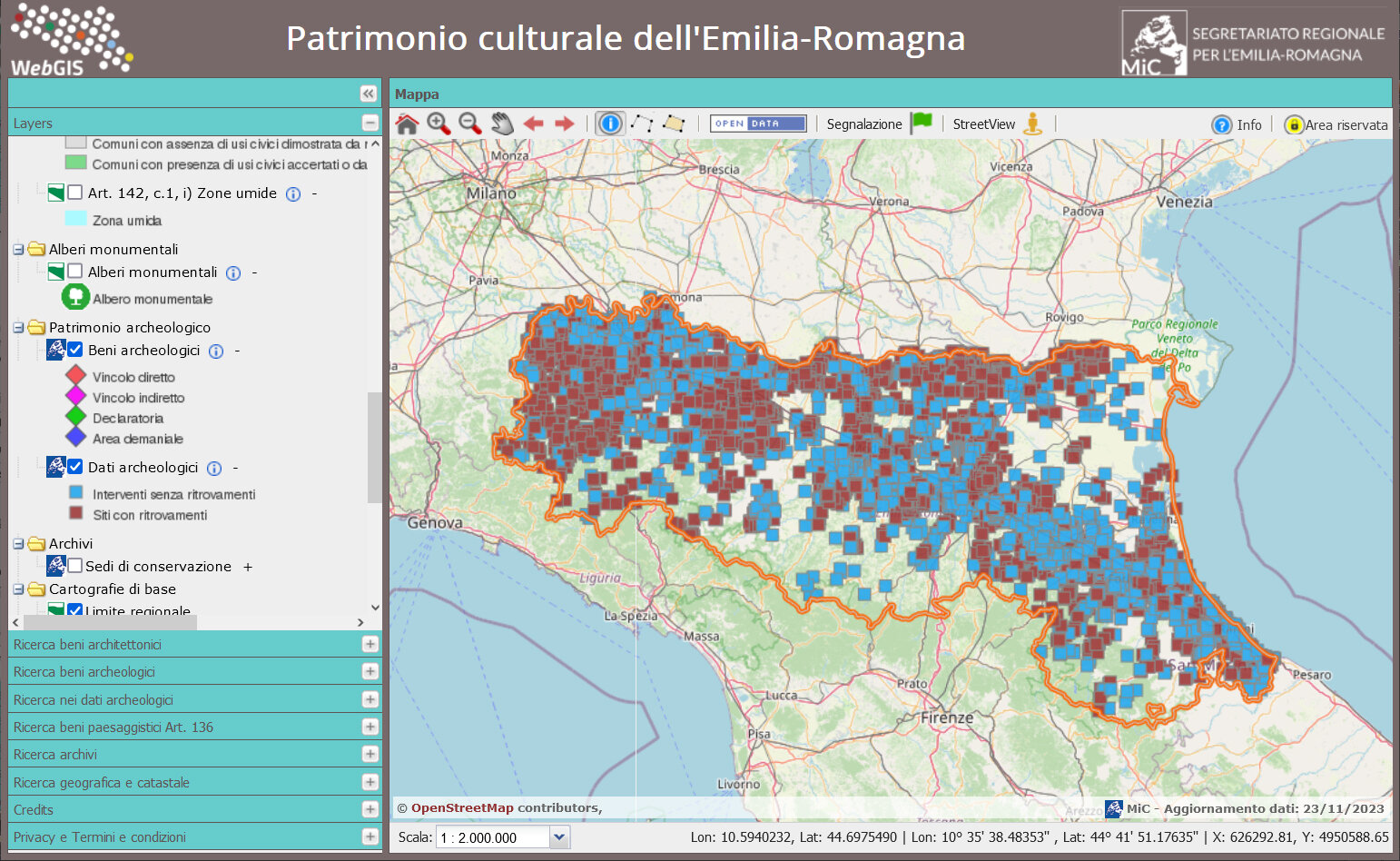
The potential of the mapping system as a research tool and a means of documenting ongoing conservation activities became even more evident when connected to a broader GIS platform on Cultural Heritage currently available in the region. In fact, new archaeological data were made accessible via the interactive maps created in 2014 by the Segretariato regionale del Ministero della Cultura per l’Emilia-Romagna (Regional Secretariat of the Ministry of Culture Emilia-Romagna), which already provided a comprehensive mapping of the region’s protected heritage 1 . This WebGIS platform has become an indispensable tool for professionals working in the fields of conservation and planning, enabling immediate identification of protected assets. The ambitious goal of locating all archaeological data, including negative outcomes, on a single platform would have increased environmental and administrative control through, for example, quicker response times to urgent requests, higher quality, and a larger amount of available information. It was possible to achieve this purpose via two fundamental conditions. First, the data acquisition strategy builds on the reliability and precision of cartographic information: precise georeferencing minimises duplications, overlaps, and data ambiguities. Since the information was now spatially linked, it was easier to identify different type of sites of interest.Secondly, cataloguing had to be succinct: extremely detailed descriptions would only slow down and potentially impede the completion of territorial mapping. The record thus had to be based on both concise and essential descriptions.
The work of Cantatore (2023) provided a basic template in which fields and terms — derived from the authority files of the Istituto Centrale per il Catalogo e la Documentazione (ICCD) (http://www.iccd.beniculturali.it/) — were refined.
Close cooperation between the regional and state local authorities was crucial. Full sharing of requirements and all other aspects of database construction, ranging from the basic structure to the definition of fields and vocabularies, enabled the rapid accomplishment of the project. Strict collaboration between the regional Soprintendenze enabled functional improvement of the ArcheoDB during the initial experimental period when the archival digitisation was initiated (see below, section 2) 2 .
From the initial stage of the work, a precious collaboration with the GNA (Geoportale Nazionale per l’Archeologia: ), was set up 3 . This cooperation laid the foundation for the future interoperability of the two systems, allowing ArcheoDB to be officially adopted by the Emilia-Romagna Soprintendenze as the standard tool for the collection of all data of archaeological inteterest.
(M.F.A.C., I.D.C., C.M., M.P., M.S.)
1. Designing a geodatabase: the case of Piacenza
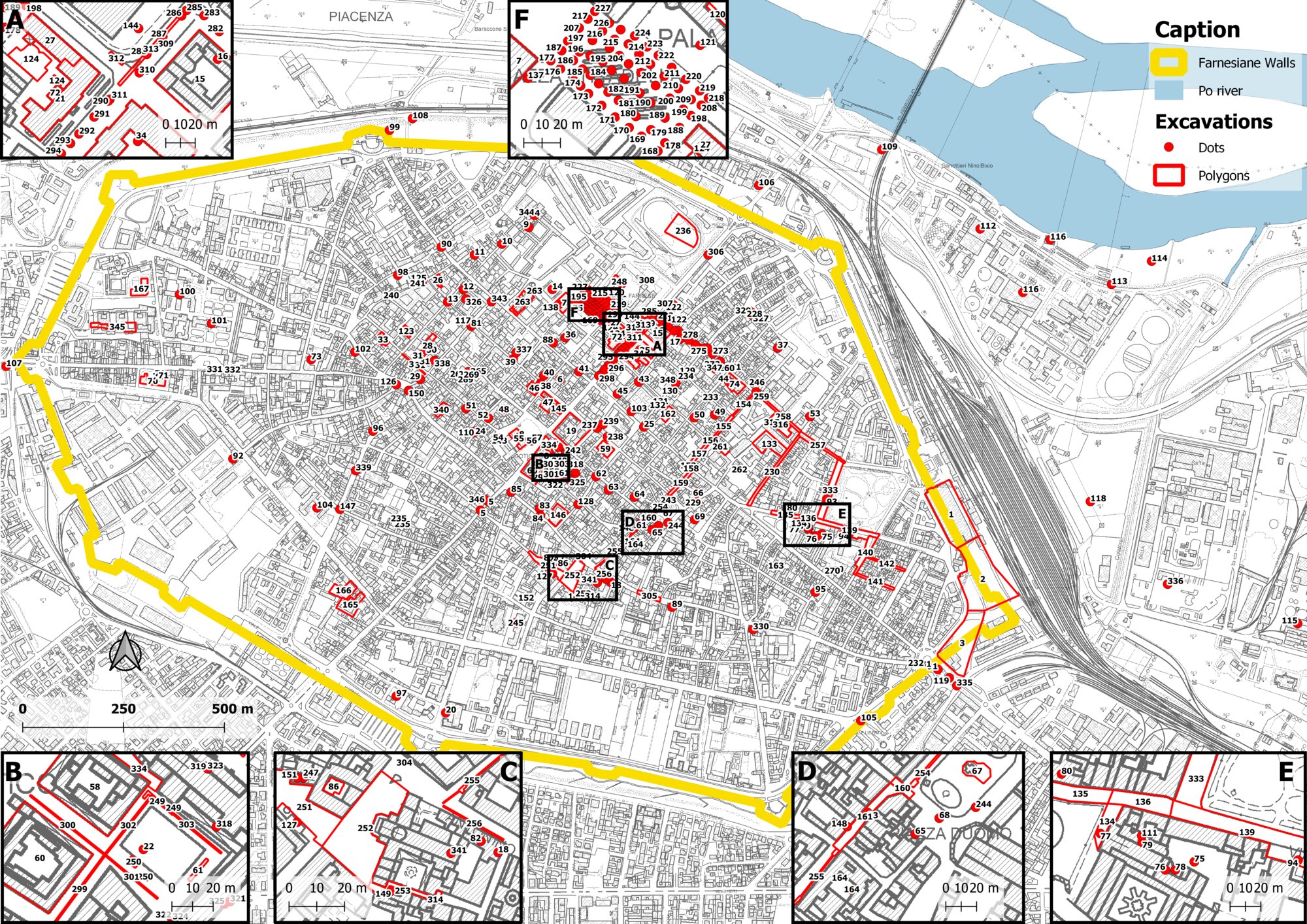
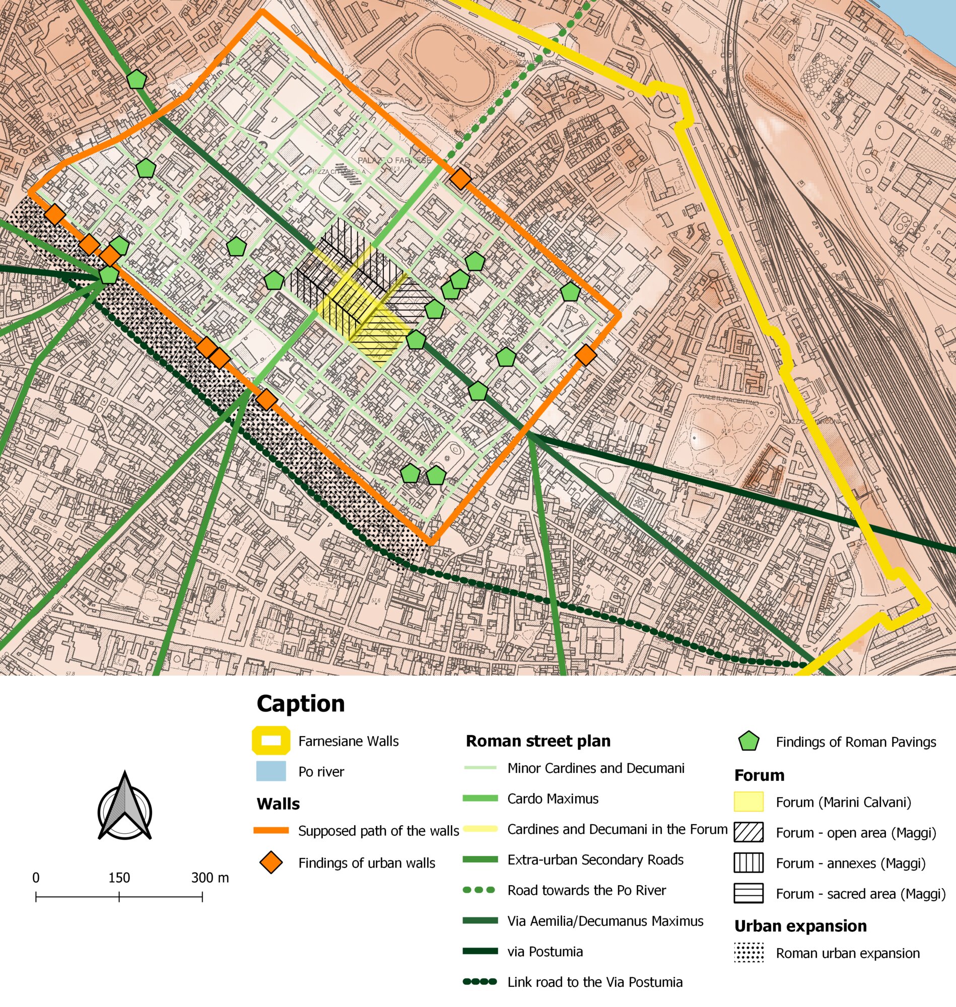
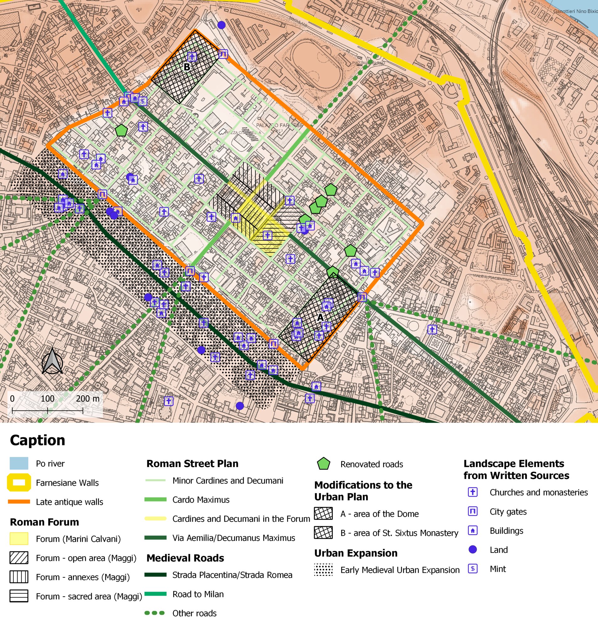
In the context of a study on the urban evolution of Piacenza, it was evident from the outset that it was necessary to design a geodatabase capable of accommodating data derived from excavations and findings. After a survey of the excavation documentation, I determined that including all archaeological investigations would be detrimental to a study focusing on a narrower timeframe (3rd century BCE – 9th century CE). I therefore considered only archaeological investigations concerning phases predating the Renaissance era, in order to optimise time and avoid processing data that would unnecessarily multiply the workload 4 . After setting these limits, it became essential to integrate the information with geographic data. Consequently, in collaboration with SABAP-PR and the Segretariato , I created an initial template to catalogue excavations, with fields primarily designed to serve specific research goals. The aforementioned formal agreement, together with the encouragement of SABAP-PR, paved the way for a data digitisation model that could serve not only academic research but also the acquisition of accurate information on the archaeology of the regional territory more generally. The work carried out led to the development of a shared model. Simultaneously, the design of a geodatabase to link collected information to the geographic positioning of individual elements within the current urban framework of Piacenza began 5 . The working group decided to utilise SpatiaLite 6 , a software that extends the SQLite database engine, to create a complete spatial database, as the former implements an SQL92 engine and the latter enhances the core of the OGC-SFS standard 7 . The advantage of this software lies in its essential architecture, resulting in simpler database management. This database consists of a single file that can be read by any computer without specific adjustments. Moreover, it is easy to transfer the entered data into a WebGIS, which represents the final goal of the original pilot project. Though these are positive aspects, a limitation is that this type of database functions as a personal database, restricting concurrent access (Furieri 2011). As for the database structure and data entry, the working group decided that the main focus would be the archaeological excavation. This decision had several consequences. First, users had to evaluate the quality of the available geographic data to determine the most appropriate means of representation on the map. We chose a symbolic representation (point) for historical excavations whose exact location and extent were unknown, and a realistic representation (polygon) for those with an accurately documented spatial extent. Given the volume of available data, we decided not to store all layers and structures uncovered in individual excavations. Instead, only the general extent was indicated. Each of these geometries was associated with a hierarchy of tables, with the main tables dedicated to excavations and their chronology. This structure made it possible to connect occupation phases with each excavation and to categorise them by period or century. In its complete version, the archaeological database for Piacenza contained 348 records, including excavations and core samples 8 , and a total of 996 phases (Figure. 1). Without delving into the specific details of each field or form created to structure the database (developed in collaboration with SABAP-PR and the Segretariato and subsequently incorporated into ArcheoDB), it is sufficient to highlight the elements that differentiate this type of cataloguing from those proposed in other projects. The guiding principles behind the database structure included simplicity, intuitiveness, and the capacity to reconcile research objectives with conservation requirements. Thus, the working team created several fields with controlled vocabulary, a simplified structure, and a data entry form. Most importantly, efforts were made to associate multiple phases with each excavation. This feature significantly enhanced the geodatabase’s usability for research purposes, enabling straightforward queries to generate advanced thematic maps. In the case of Piacenza, this structure facilitated the exploration of the city’s urban evolution. The reconstruction of the Roman city layout could be visualised on different cartographic bases, displaying findings such as sections of city walls or paved streets (Figure. 2). Furthermore, by creating a specifically structured data entry form, I was able to incorporate information from written sources. Piacenza is the city in northern Italy that preserves the highest number of medieval parchments dating from the 8th to the 11th century, with the possibility of examining approximately 400 documents from the 8th and 9th centuries alone. The merging of data from written and material sources fostered a better understanding of urban evolution between Late Antiquity and the early Middle Ages (Figure. 3). In those periods, Piacenza was characterised by city walls and churches. The former, preserving the layout established in the 5th and 6th centuries, included walls, outer defensive structures, towers, gates, and posterns; they were primarily owned by the publicum, with only the king or emperor authorised to alienate them. Both churches and monasteries experienced exponential growth. Written sources document the existence of at least 28 religious buildings within the city walls and the suburban area. These structures did not significantly alter the urban layout, with the exception of the San Sisto monastery and the episcopal area, which included the cathedral (Santa Giustina), San Giovanni Evangelista, the baptistery, the episcopal residence, and the residences of clergy and servants, as well as the canonical residence still under construction at the end of the 9th century. All these elements disrupted the urban sectors in which they were erected (northwestern and southeastern corners). Even so, they were not liturgically oriented, being influenced instead by the Roman orthogonal grid: the urban layout remained largely intact. Piacenza’s inhabitants continued to walk along the paths of ancient Roman roads, which were no longer paved but consisted of beaten earth and scattered bricks. Even the Roman Forum, likely no longer surrounded by the buildings that once bordered it, remained recognisable, as indicated by 9th-century documents (Cantatore 2023).(M.F.A.C.)
2. The development of ArcheoDB on a regional scale
In recent years, two collaborative opportunities arose simultaneously, leading to the refinement of the system’s initial template and the successful completion of the geodatabase, rendering it compatible with the GNA.
In 2019, collaboration with the ‘Area Geologia, Suoli e Sismica’ office of the Emilia-Romagna Region was re-established within the framework of the ‘Archaeological Database Project’ initiated in the 1990s (Di Cocco and Martini 2006). Its primary goal was to obtain accurate archaeological dating on a regional scale, in order to document the superficial stratigraphic units targeted by the National Geological Cartography Project (CARG). The Geological Service’s essential requirements included a concise and flexible data structure, with a focus on chronological data and the depths at which findings were recorded. The database needed to allow for the entry of multiple chronological phases and their respective depths from the current ground level within the same site.
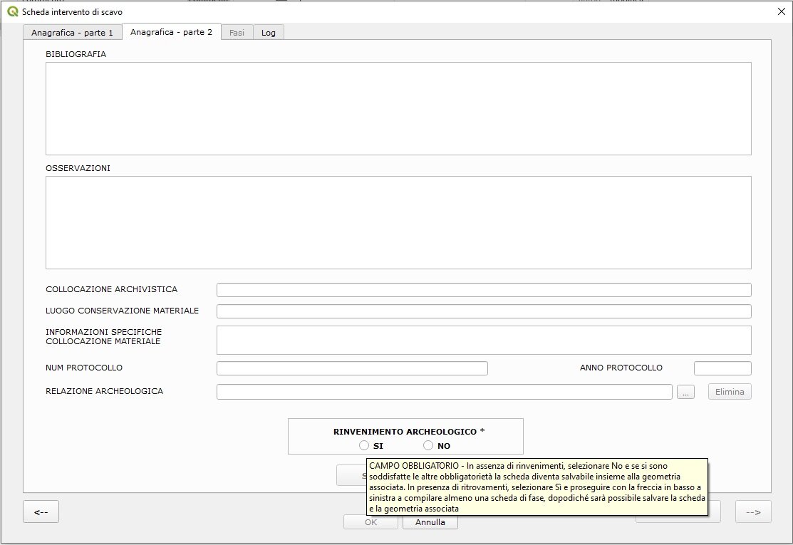
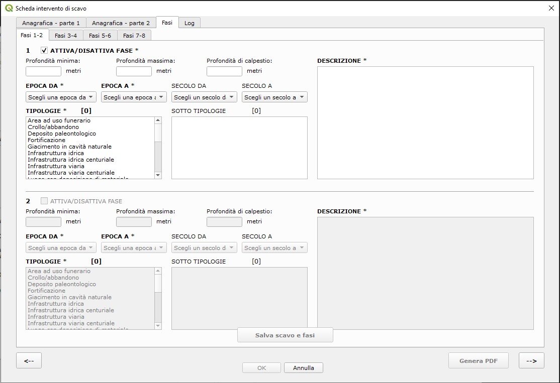
Particular interest was placed on access to continuously updated information from new excavations ( https://ambiente.regione.emilia-romagna.it/it/geologia/geologia/carg/i-dati/la-banca-dati-archeologica ). At the same time, the new CARG sheets also covered territories within the Lombardy and Veneto regions, necessitating interregional collaboration based on national standards still in the process of being developed 9 . The collaboration between these regions enabled the involvement of the necessary expertise for the comprehensive IT development of the relational geodatabase, with the support of regional authorities. This support facilitated the design and implementation of the data structure within the existing geodatabase, the development of the required graphical interfaces for data input and modification, the creation of procedures for automatic uploads and exports, and the implementation of analysis tools and reporting mechanisms. These aspects were essential to ensure the consistent population and updating of the digital archive in a simplified manner by professionals conducting archaeological investigations. They also guaranteed the utmost reliability and completeness of the data, along with systems for monitoring the accuracy and consistency of the information entered. The second crucial collaboration was with the GNA developers, whose data structure is still being finalised. This collaboration involved meticulous mapping of the fields in both systems to ensure the seamless transfer of data collected through ArcheoDB 10 . The working team maintained a simple approach to data entry and streamlined the vocabularies. This approach excluded terms expected by national documentation standards but not applicable to the archaeology of Emilia-Romagna. ArcheoDB retained its specific focus on multi-stratified sites. The team organised the documentation process using a one-to-many relationship between the primary record—containing comprehensive information about archaeological interventions and random findings—and the individual records dedicated to specific chronological macro-phases when archaeological excavations yielded positive results (Figure. 4 - Figure. 5 - Figure. 6). The first challenge, primarily conceptual, was to clearly define the subject to be catalogued. In the archaeological context of Emilia-Romagna—as in many other Italian regions—information, interventions, and sites tend to overlap. The choice to record each archaeological intervention separately would undoubtedly have simplified the compilation of individual records, but it would also have resulted in multiple overlapping areas. Moreover, it would have contradicted the underlying logic of the entire geodatabase, which catalogues every architectural, archaeological and landscape asset with particular attention to avoiding data overlap. For example, when an architectural asset has been subject to multiple conservation measures over time, these are recorded as progressive updates to the existing record, with adjustments to its delimitation when necessary. More generally, the same topographical logic guided the decision to dedicate a single record to each site, offering a concise overview of all findings or negative outcomes from investigations conducted at that location. Contributors were therefore required to verify the existence of any previous records in the area before entering new data. They also had to update existing records through a specific template re-attribution process managed by the cataloguing supervisor. This process preserves the memory of the previous compiler and records the dates of updates. This choice also facilitates the accessibility of integrated mapping in the WebGIS, ensuring that all available information can be accessed with a single click on the map. It bears repeating that the team conceived the project to ensure the easy identification of areas where archaeological data are available, not to replace more in-depth consultation of archival or bibliographic resources. It is this essential logic that ensures rapid territorial coverage. This approach allowed for the retrieval of past data for entire municipal, and in some cases provincial, territories within a short timeframe—from ٢٠٢٠ to November ٢٠٢٣. As of now, more than ١٢,٠٠٠ sites have been catalogued by compilers.The initial data recovery campaigns were launched by the regional Soprintendenze in ٢٠٢٠, involving interns from the Scuola di Specializzazione in Beni Archeologici of the Universities of Bologna, Trieste, Udine, and Venice Ca’ Foscari. This combination of expertise led to the development of clear instructions for data entry and a vademecum to clarify the purpose of each field and the interpretation of vocabulary. Most importantly, these early campaigns contributed to improving the structure of the system by eliminating redundancies and resolving ambiguities.
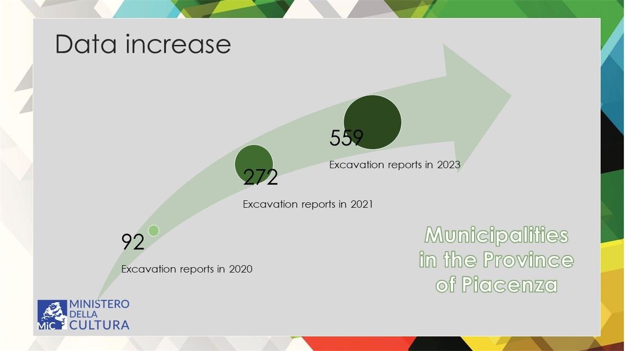
At the same time, the working team made the fundamental—albeit complex—decision to design an interface allowing concurrent data entry by multiple accredited users. Each user was assigned specific credentials, with varying territorial scope and the ability (or restriction) to modify previously entered data. Each compiler operated through a downloadable plugin within the open-source QGIS system, enabling direct and streamlined interaction with the geodatabase. Any record, along with its associated geometry, became immediately available to other users upon saving, thus minimising the risk of duplicate entries. The recovery of archival data was made possible, as will be further detailed, through the involvement of expert archaeologists working in collaboration with the Soprintendenze and the allocation of funds specifically dedicated to the implementation of data for the GNA. These funds were made available by the Direzione Generale Archeologia, Belle Arti e Paesaggio (DG ABAP – Directorate General for Archaeology, Fine Arts, and Landscape 11 ). Full interoperability between ArcheoDB and the GNA standards was implemented and formally recognised. In this context, ArcheoDB functions as a regional hub and data collection centre, ensuring consistency and the avoidance of duplicate records subject to cataloguing obligations under various legal frameworks. It enables all authorised personnel to enter data directly into the central server: as each record is added, it becomes immediately accessible to all users. Consequently, once a site is catalogued, it is instantly visualised in real time on the maps available to all users through the plugin, thereby preventing erroneous duplication. As a result, the regional Soprintendenze assumed a leading role in the retrieval of archival data and in providing more efficient consultation tools to support the timely initiation and development of protection procedures. Another significant advancement resulted from the implementation of the Preventive Archaeology Guidelines and the subsequent requirement for professionals to use the standardised data entry template, as specified in the DPCM of ١٤ February 2022 12 . Faced with this new requirement, and in order to strengthen ArcheoDB’s role as the regional hub, it became necessary to ensure that all preventive archaeological measures were implemented at the MOSI level (MOdulo di area/SIto archeologico = Area Form/Archaeological Site) through the use of the regional geodatabase. This enabled professionals both to access and reuse all available information and to enter new data. Consequently, starting in June 2022, training courses and user support initiatives were organised to assist the growing number of data entry personnel. The increasing availability of a standardised and comprehensive dataset, combined with a user-friendly data entry interface, contributed significantly to the project’s success. Between 2022 and 2023, the working team achieved two important goals: the completion of the ArcheoDB template upon submission of new excavation documentation, and the real-time publication of updated data. The completion of the form upon submission began experimentally and on a voluntary basis in 2022, providing professionals with an opportunity to familiarise themselves with the data entry process while simultaneously managing archaeological documentation. The underlying aim of this trial phase was to ensure that completing the form did not represent an excessive burden for professionals, but rather served as a verification tool. The template supports the completeness of essential information and simplifies data retrieval through mandatory fields and internal consistency checks. This feature proved particularly useful in cases involving extensive documentation, where retrieving specific details could be complex. During data entry, compilers attach the excavation report, which becomes immediately available in digital format to the Soprintendenze . Furthermore, once completed, the form can be exported as a printable PDF including a cartographic extract and a timestamp. As of 1 January 2023, the completion of the ArcheoDB template became mandatory for all submissions of excavation documentation to the Soprintendenze of Emilia-Romagna. This decision brought two major benefits to the project: (1) it ensures the continuous and timely updating of the geodatabase with all archaeological data at the point of submission; (2) the new records are entered directly by the professionals responsible for the excavations. This guarantees both the quality of the data and the precision of the georeferencing, as it derives directly from fieldwork, without requiring reinterpretation or synthesis by a third party. Entrusting professionals with the responsibility of producing high-quality public data also recognises their expertise and attributes intellectual authorship appropriately. At the same time, a validation phase was introduced and assigned to archaeologists from the Soprintendenze , allowing for improvements to the data when necessary. A dedicated desktop application—equipped with search and correction functions—was developed to streamline this review process. As of November 2023, 230 professionals had been authorised to enter data into ArcheoDB. Approximately 100 sites are added each week, with an increasing proportion of the data originating from new excavation projects. During the first eleven months of 2023, over 800 records concerning interventions conducted in the same year were entered into the system, underscoring the validity of the decision to integrate data entry into ArcheoDB with the submission of documentation to the Soprintendenze . These figures reflect the substantial workload consistently managed by the Soprintendenze and the efficiency of the new workflow. The decision to make all available data accessible in real time marked a radical yet necessary shift (Figure. 7). To balance transparency and data reliability, the working group added a disclaimer clarifying the non-validation status of some records. This was the only viable approach to ensure full and timely data sharing with the broader community, including researchers, field professionals, and stakeholders involved in land management and planning. Experience with the WebGIS has demonstrated that, although heritage data is always susceptible to improvement and necessarily partial, its public availability fosters correction and enrichment. It promotes the engagement of various stakeholders in the protection, management, planning, and enhancement of the territory. In many cases, new data have emerged from sources such as local authority archives or from individuals possessing in-depth and site-specific knowledge. At the same time, some critical issues have emerged. Those planning interventions on the territory have shown an increasing reliance on the WebGIS platform, at times to the detriment of consulting complementary sources, especially traditional and printed ones. Although this shift entails some risk, the simplification it offers is, in many respects, appropriate: it provides the most comprehensive and up-to-date synthesis of available archaeological information.
One year after its launch (15 September 2022), the database has been positively received. It has effectively supported decision-making processes in the protection of archaeological heritage and has become an immediate and reliable source of archaeological information for the scientific community.
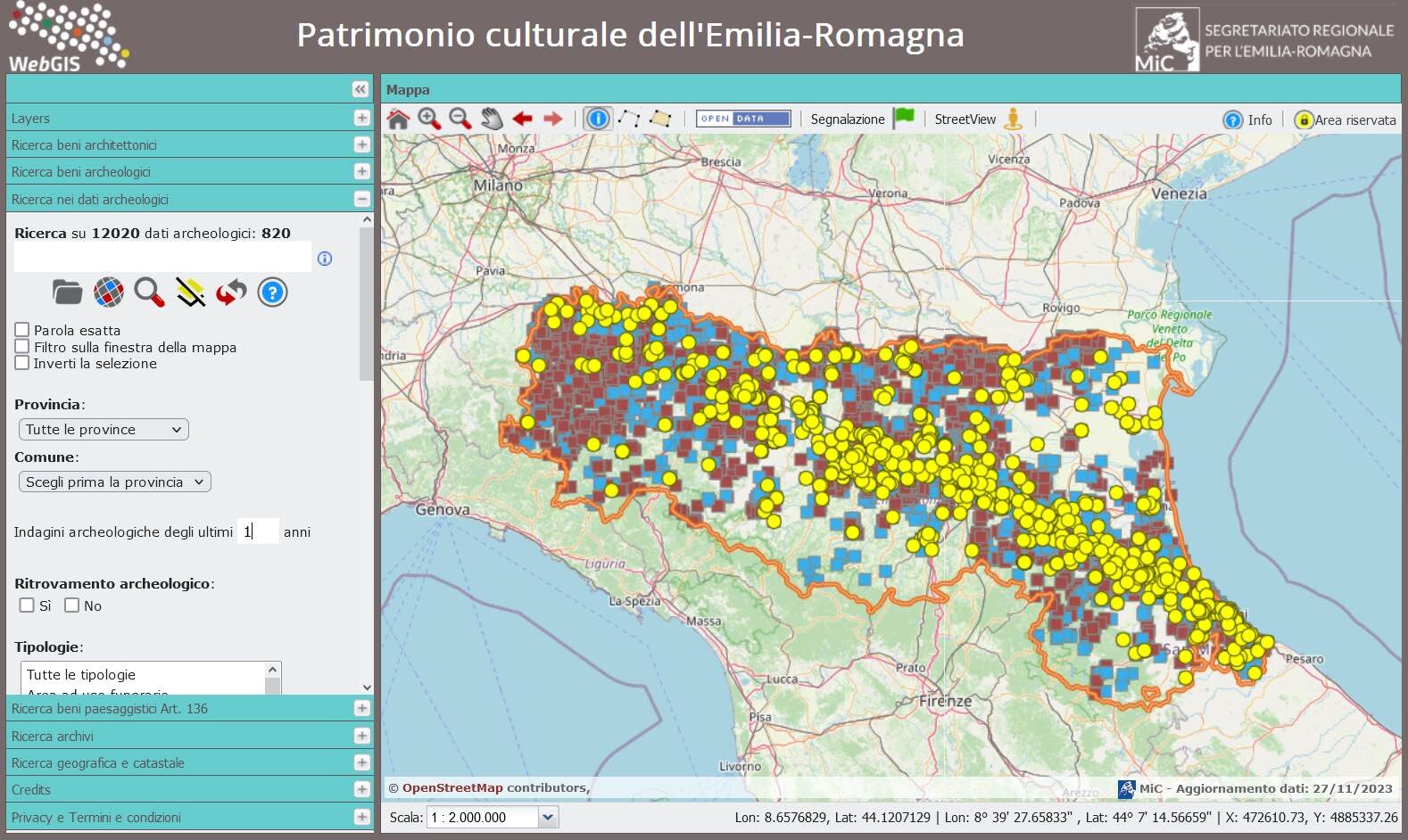
For planners and researchers alike, the constantly updated WebGIS interface facilitates the extraction of data based on criteria such as geographic location, chronology, type of evidence, or depth of findings. It is also possible to filter for recently investigated sites, providing essential and timely “excavation news” (Figure. 8).
Furthermore, the provision of open data through web services—particularly WMS (Web Map Service) and WFS (Web Feature Service)—has significantly expanded the system’s potential. These services allow users to reuse and integrate datasets within custom cartographic projects, maintaining an active link to the continuously updated source. This ensures that the most recent information is always available, even when visualised in external platforms or systems.
(I.D.C., M.S.)
3. The experience of the Parma Soprintendenza office (SABAP-PR)
The necessity to catalogue excavation data compelled SABAP-PR officials to reorganise their archaeological archives 13 , dividing documents into four main territorial groups and and creating an Excel-based inventory 14 . A similar approach was adopted for other specific archival collections, such as documentation centres located in different offices (including Bologna’s Soprintendenza office and the civic museums of Travo and Pianello Val Tidone) or archives organised thematically (for example, the archive of prehistoric excavations) 15 .
Additionally, the team labelled all excavation documentation folders with their respective inventory codes. A similar reorganisation is currently underway for the extensive archive of archaeological drawings, which, until about 1995, were separated from the written documentation and stored independently.
The creation of ArcheoDB records involved multiple approaches:
- Internal Soprintendenza staff directly catalogued excavation interventions;
- Initial contracts with external companies and professionals were funded through annual allocations provided by the General Directorate of the Ministry (DG ABAP) for cataloguing activities 16 ;
- Archaeologists appointed by DG ABAP have provided crucial support, beginning the organisation of archives and cataloguing work in July 2021 17 ;
- Public project funds have supported the reorganisation, digitisation, and cataloguing of external archives 18 .
- ‘Archival Location’ which uses abbreviations (e.g., ‘SABAP PR, PRP 546’) to indicate respectively physical location, archival collection, and inventory number 19 , thereby facilitating further investigations or verifications;
- ‘Notes’ associated with the Datum Point field (‘Quota zero’) to indicate ‘where’ and “how’ the information was detected (via GPS, Google Earth, CTR, etc.);
- ‘Notes’ linked with the positioning methods field (‘Metodologia posizionamento’), describing the means used to determine the location of the excavation area (e.g., by using GPS, cadastral data, IGM, etc.) 20 .
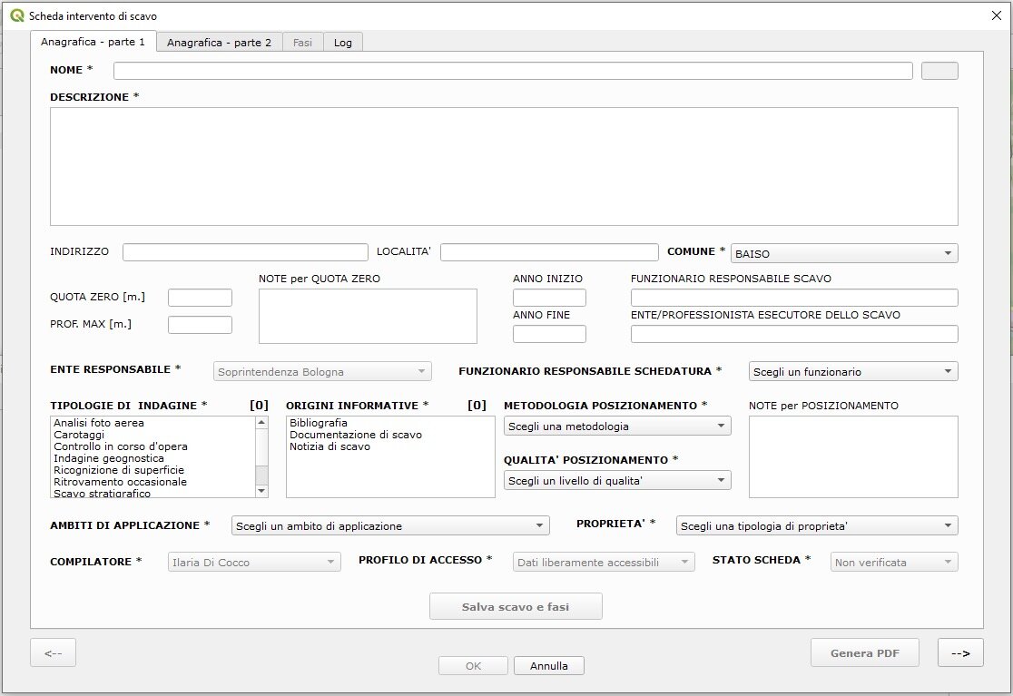
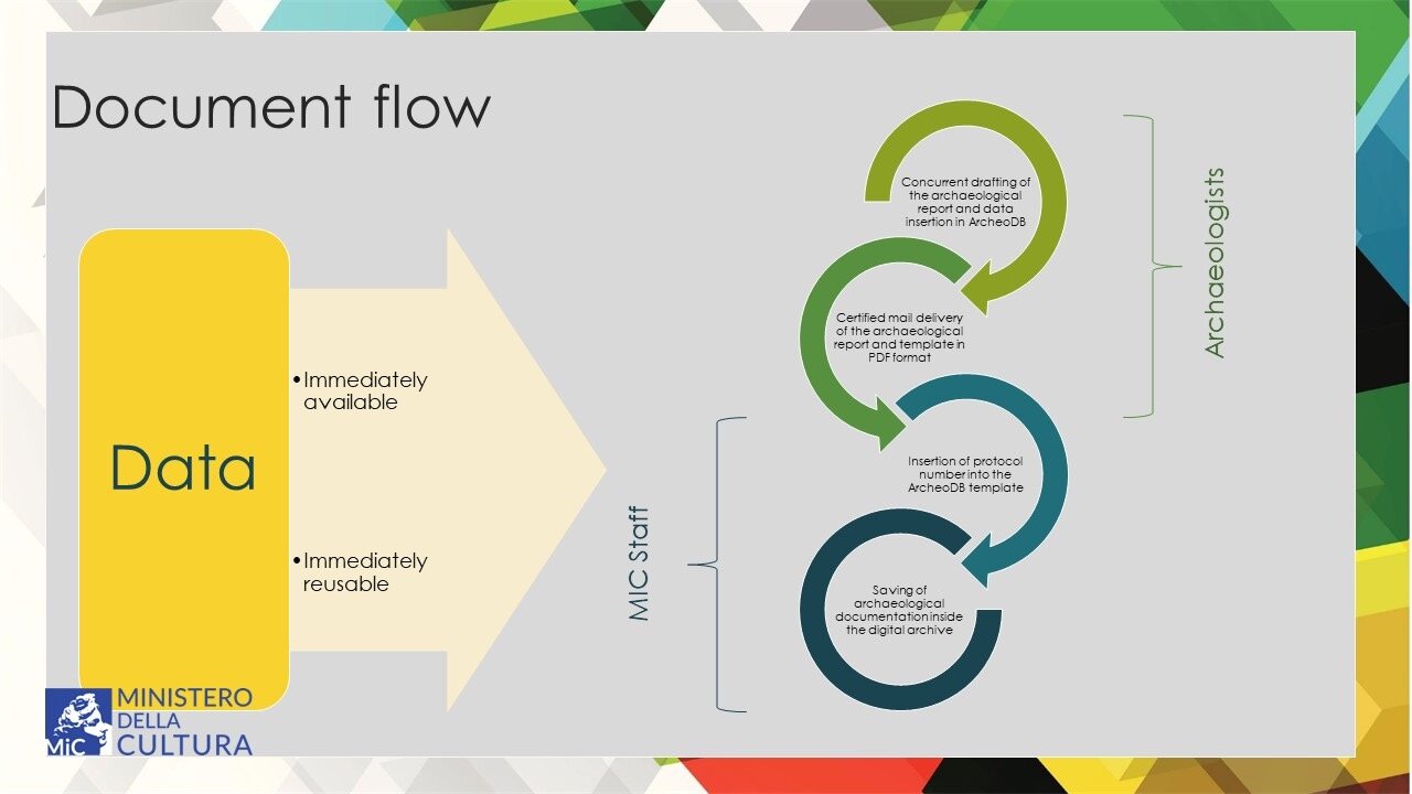
Following the introduction of the mandatory ArcheoDB template (effective from 1 January 2023), professional archaeologists implemented operational changes in the submission of excavation reports. As a result, SABAP PR resolved to accept documentation exclusively in digital format (Figure. 9). 21 . The documentation is transmitted via PEC (Certified Electronic Mail) and assigned a protocol number within the G.I.A.D.A. system (the ministerial digital archive). The ArcheoDB form now refers to the original documentation by recording the protocol number and year, which has replaced the previous reference to archival location.
These developments required the Superintendence officers to adopt a shared strategy for managing data flow: once the report is received via PEC, it is saved in the management system along with the exported PDF of the ArcheoDB record (Figure. 10). After verifying the completeness and accuracy of the documentation, the officer accesses the “ArcheoDB Desktop” application, searches for the corresponding record ID, integrates the protocol number, and validates the record. The final documentation is then stored in a digital archive folder using a codified naming convention.
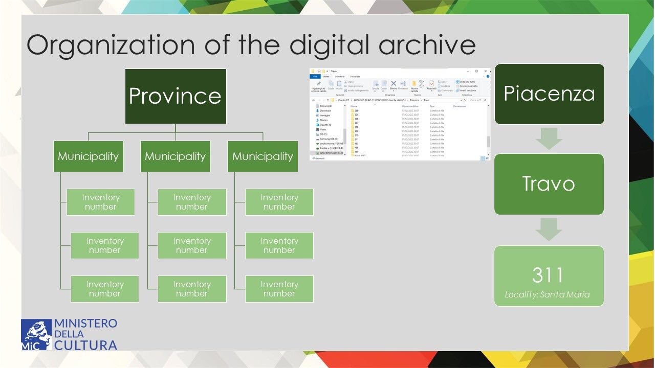
This workflow has had significant practical implications. From a conservation standpoint—which lies at the core of the Soprintendenze’s mission—the secure preservation of excavation documentation is ensured, safeguarding a digital copy in case the physical records are lost or deteriorate. Additionally, the complete retrieval and georeferencing of the documentation enable more effective territorial monitoring. For instance, in the municipalities of the province of Piacenza, all interventions have been mapped: the WebGIS for that area now contains the main contents of the local archival records, effectively replacing the need to consult paper documents (Figure. 11). A similar process is currently being undertaken for the substantial documentation of the province of Parma.
From the user’s perspective, the ability to retrieve excavation documentation remotely has significantly improved. This is particularly relevant considering that consultation of such documentation is mandatory for the execution of public works in Italy 22 . The full availability of georeferenced excavation data also plays a strategic role in territorial planning. Numerous municipalities in Emilia-Romagna are currently engaged in the drafting or revision of urban planning tools, actively integrating the archaeological information provided by ArcheoDB into their analyses.
Moreover, the platform serves as a scientifically robust and comprehensive reference point for a wide range of research and outreach initiatives. These include undergraduate and doctoral theses, institutional and independent research projects, as well as preliminary studies supporting the development of new museum exhibits, archaeological parks, and tourist guides. In this way, ArcheoDB contributes to ensuring that all such activities are grounded in accurate, verified, and up-to-date archaeological data.
(C.M., M.P.)
4. Conclusion: Current status and future perspectives
The development of ArcheoDB remains aligned with its original objectives. The digital template and the core functionalities of the cartographic plugin have reached a reliable level of stability. Nonetheless, regular maintenance and continuous data enhancement remain indispensable. Ongoing updates are essential not only to ensure compliance with evolving GNA standards and GIS platform developments but also to strengthen the protection of archaeological heritage.
The principal aim of ArcheoDB is to ensure complete and consistent data entry throughout the regional territory. This goal will be progressively achieved through systematic archival review and the structured input of new excavation documentation. A significant opportunity is currently offered by the drafting of the General Urban Plans (PUG) underway in several municipalities. In many cases, the adoption of the ArcheoDB model has increased local awareness of archaeological assets and fostered greater engagement with cultural heritage data.
While historical data recovery is time- and resource-intensive, ArcheoDB provides a continuously updated and accessible reference framework without requiring additional long-term investments.
Furthermore, the integration of ArcheoDB into the Regional Crisis Unit—an inter-institutional body responsible for emergency response involving cultural heritage—represents a crucial advancement. Composed of representatives from the Regional Secretariat, the Soprintendenze, and other Ministry of Culture (MiC) entities, this Unit benefits from real-time access to reliable archaeological information. Such access is critical for identifying and prioritising areas requiring immediate intervention during emergencies such as earthquakes or floods.
(M.F.A.C., I.D.C., C.M., M.P., M.S.)
References
- Cantatore, M.F.A. 2023. Da Placentia a Placencia. Trasformazione della morfologia urbana di Piacenza dall’età tardoantica all’alto Medioevo. Sesto Fiorentino (FI): All’Insegna del Giglio.
- Cardarelli, A., M. Cattani, D. Labate, and S. Pellegrini. 2001. “Il sistema Mutina: esperienze ed evoluzione.” In Rischio Archeologico: se lo conosci lo eviti. Congress Proceedings (Ferrara 2000), edited by M.P. Guermandi, 200-210. Firenze: All’Insegna del Giglio.
- Cirelli, E. 2008. Ravenna: archeologia di una città. Firenze: All’Insegna del Giglio.
- Cirelli E. 2016. “Applicazioni GIS all’archeologia urbana: il caso di Ravenna.” Archeologia e Calcolatori 27, 209-226.
- Di Cocco, I., and A. Martini. 2006. “Geology and archaeology: the contribution of archeo-database to the construction of Emilia-Romagna Geological Cartography (CARG project).” 5th European Congress on Regional Geoscientific Cartography and Information Systems., Proceedings. II, 214-216. Barcelona: Institut Cartogràfic de Catalunya, Institut Geològic de Catalunya.
- Gelichi, S. 2001. “Un rischio calcolato. Qualche nota a margine della carta di Cesena.” In Dalla carta del rischio archeologico di Cesena alla tutela preventiva urbana in Europa, Congress Proceedings (Cesena 1999), edited by S. Gelichi, 7-9. Sesto Fiorentino: All’Insegna del Giglio.
- Gelichi, S., and C. Negrelli, eds. 2008. A misura d’uomo. Archeologia del territorio cesenate e valutazione dei depositi. Borgo San Lorenzo (FI) Sesto Fiorentino: All’Insegna del Giglio.
- Gelichi, S., and C. Negrelli, eds. 2011. A piccoli passi. Archeologia predittiva e preventiva nell’esperienza cesenate, Congress Proceedings (Cesena, Pinacoteca Cassa di Risparmio, 28 November 2008). Sesto Fiorentino: All’Insegna del Giglio.
- Gelichi, S., A. Alberti, M. Librenti. 1999. Cesena: la memoria del passato. Archeologia urbana e valutazione dei depositi. Sesto Fiorentino: All’Insegna del Giglio.
- Guarnieri, C., ed. 2000. Progettare il passato. Faenza tra pianificazione urbana e Carta Archeologica. Firenze: All’Insegna del Giglio.
- Marini Calvani, M. 1990. Archeologia. Schedario topografico dei ritrovamenti archeologici nei territori di “Placentia” e “Veleia”. Piacenza: Cassa di Risparmio di Piacenza e Vigevano.
- Negrelli, C., ed. 2021. A misura d’uomo 2. Aggiornamento alla carta del potenziale archeologico di Cesena. Sesto Fiorentino: All’Insegna del Giglio.
- Prati, L. 2001. “C.A.R.T. a Forlì: la Carta del potenziale archeologico del territorio forlivese.” In Rischio Archeologico: se lo conosci lo eviti. Congress Proceedings (Ferrara 2000), 211-214, edited by M.P. Guermandi. Sesto Fiorentino: All’Insegna del Giglio.
- CARG, viewed 21 October 2023, https://ambiente.regione.emilia-romagna.it/it/geologia/geologia/carg/i-dati/la-banca-dati-archeologica
- Geoportale Nazionale per l’Archeologia (GNA), viewed 14 October 2023, http://archeo.beniculturali.it/it/336/il-geoportale.
- ICCD = Istituto Centrale per il Catalogo e la Documentazione, viewed 14 October 2023, http://www.iccd.beniculturali.it/.
- Furieri, A. 2011. SpatiaLite Cookbook, viewed 14 October 2023, https://www.gaia-gis.it/gaia-sins/spatialite-cookbook-5/index.html.
- Mappa, viewed 14 October 2023, http://www.mappaproject.org/.
- Patrimonio Culturale dell’Emilia-Romagna, viewed 14 October 2023, https://www.patrimonioculturale-er.it/webgis/.
- PTCP = Tamagni, D. 2007. Piano territoriale di coordinamento provinciale. Ricognizione e schedatura delle aree archeologiche, viewed 14 October 2023, https://www.provincia.pc.it/pagina.php?IDpag=274&idbox=49&idvocebox=298.
- RAPTOR = Ricerca Archivi e Pratiche per la Tutela Operativa Regionale, viewed 14 October 2023, https://www.raptor.beniculturali.it/.
- SITAR = Sistema Informativo Territoriale Archeologico di Roma, viewed 14 October 2023, https://www.archeositarproject.it/.