1. Introduction
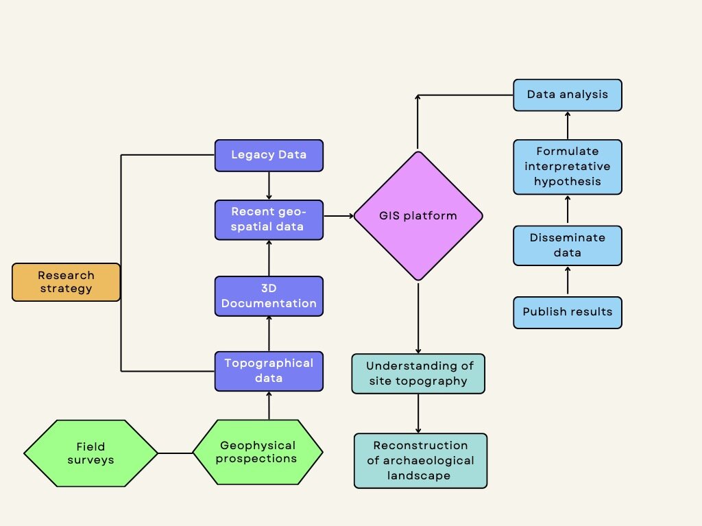
This paper presents the results of a GIS-based integrated approach applied by the archaeological project for the urban area of Roman Atella (Campania, Italy) based on 1) the integration of new and legacy data through the use of a GIS platform; 2) a geophysical magnetometry survey undertaken at Sant’Arpino (Caserta); 3) field and proximally sensed data analysis (Figure. 1). It describes the different survey methodologies applied and presents the results with an interpretation and discussion. The research is part of the Atella Archaeological Excavation Project (MIC | MIC_SABAP-CE | 26/06/2024 | 0013094-A) which aims to investigate the buried remains of the Campanian city in order to understand its urban topography through an integrated approach, combining the digitization of legacy data and its integration with survey data (Figure. 2). The project was instigated by the Department of Humanities Studies of University of Naples with the Soprintendenza Archeologia, Belle Arti e Paesaggio (hereafter SABAP) di Caserta and SABAP Area Metropolitana di Napoli to establish a digital and open access archaeological map of the remains of the ancient city and its ager.
The geology of the area is of volcanic origin, situated to the north of Mount Vesuvius and the caldera of Campi Flegrei. Eruptions from these locations deposited volcanic material through pyroclastic flows across the Campanian plain. In this region, partially molten lapilli (ranging from 2 to 64 mm) fused into solid layers, cooling after each volcanic episode and creating stratified layers of tuff. The deposits surrounding the site were laid down during the historic period (since approximately AD 79) and overlay earlier Pleistocene geologies (cf. Di Vito et al. 2021).
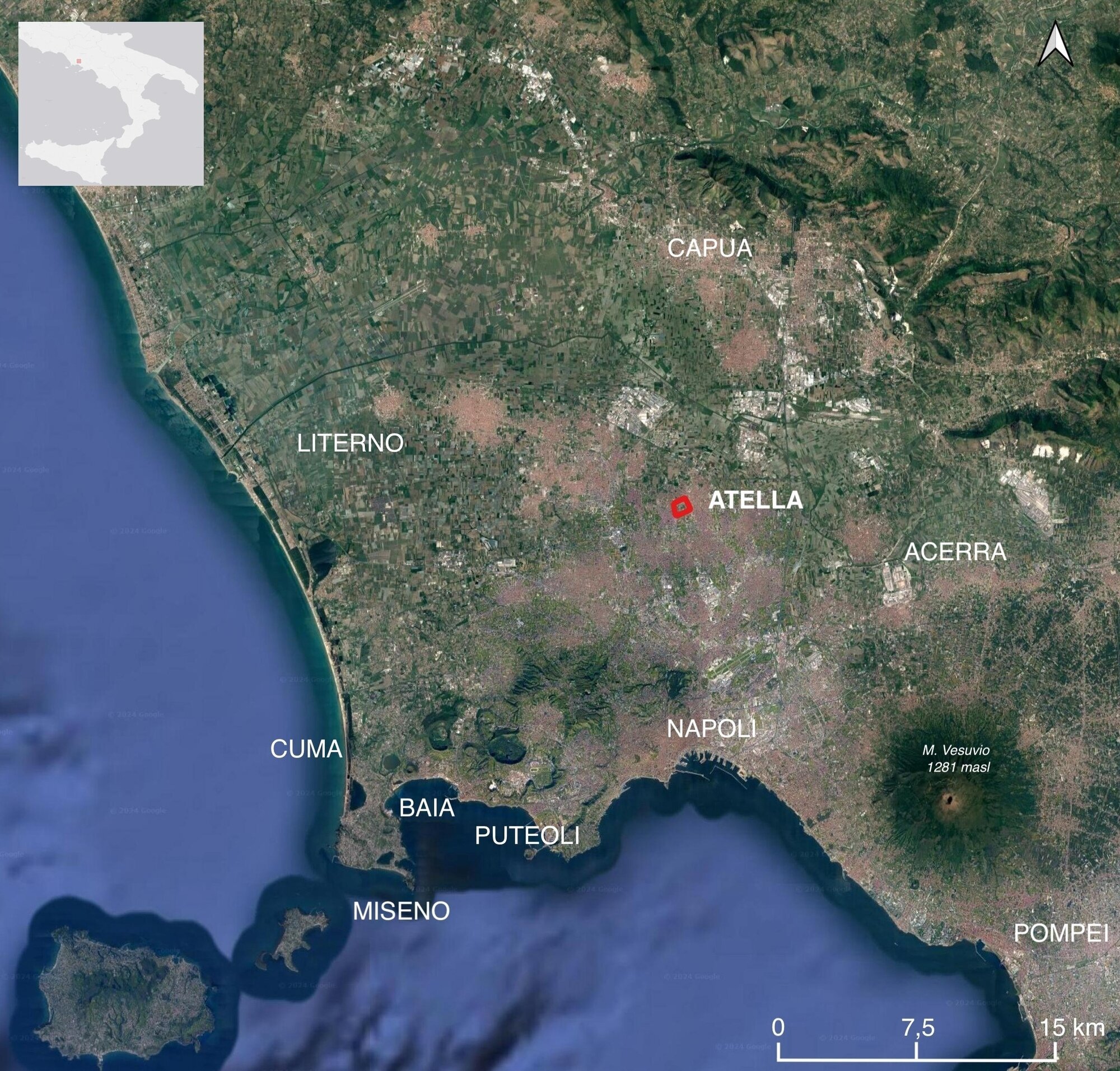
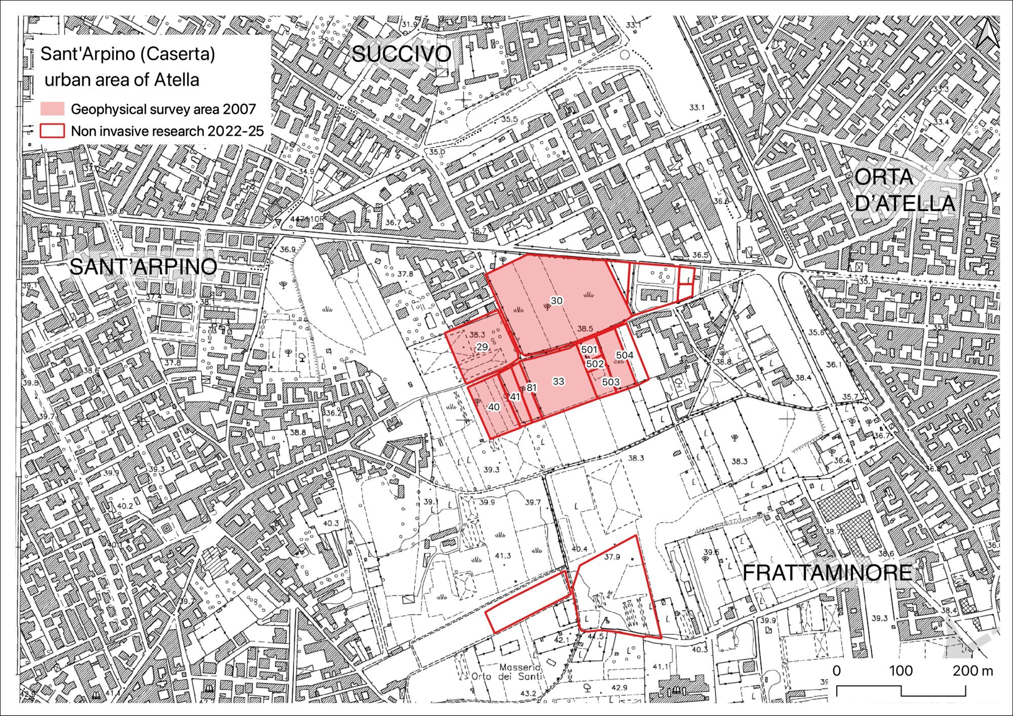
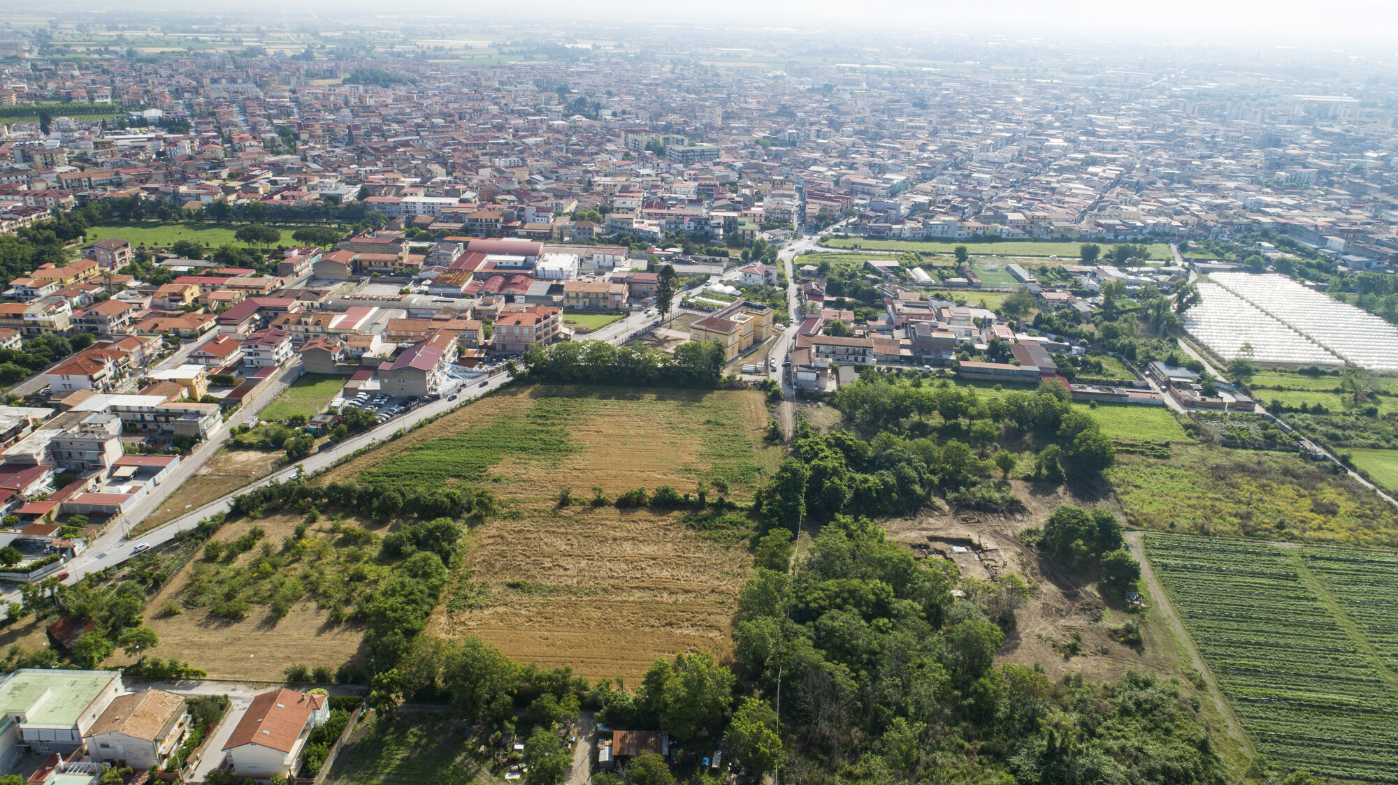
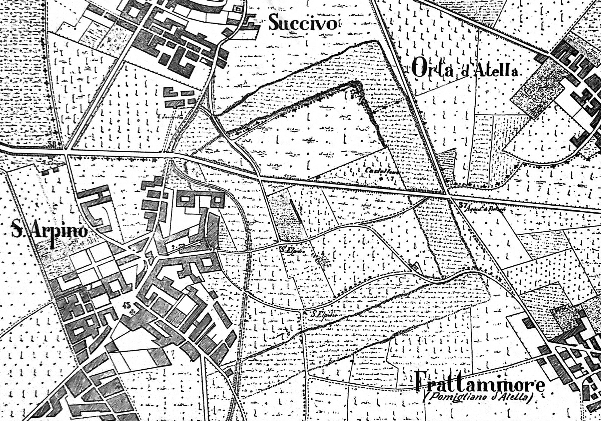
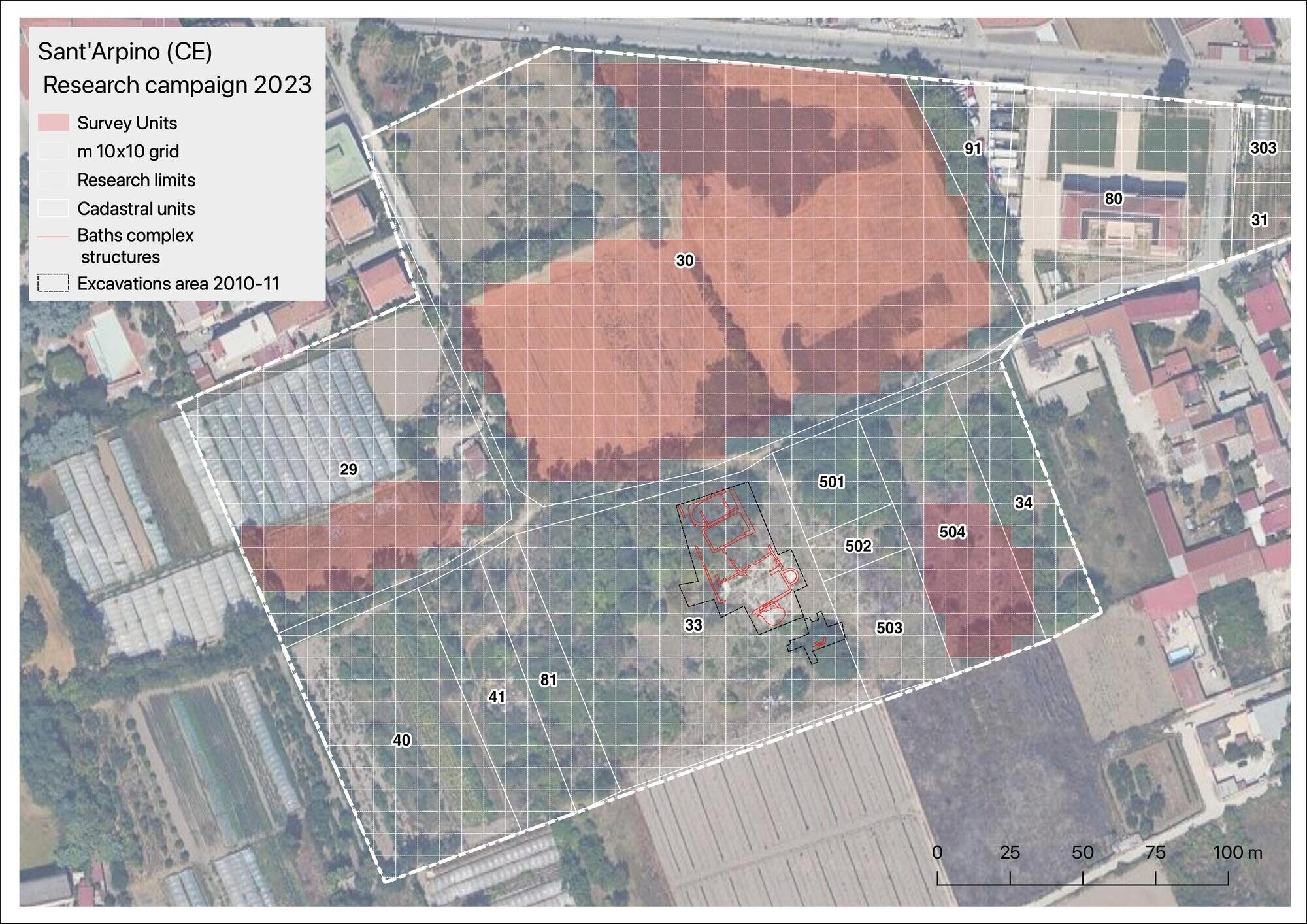
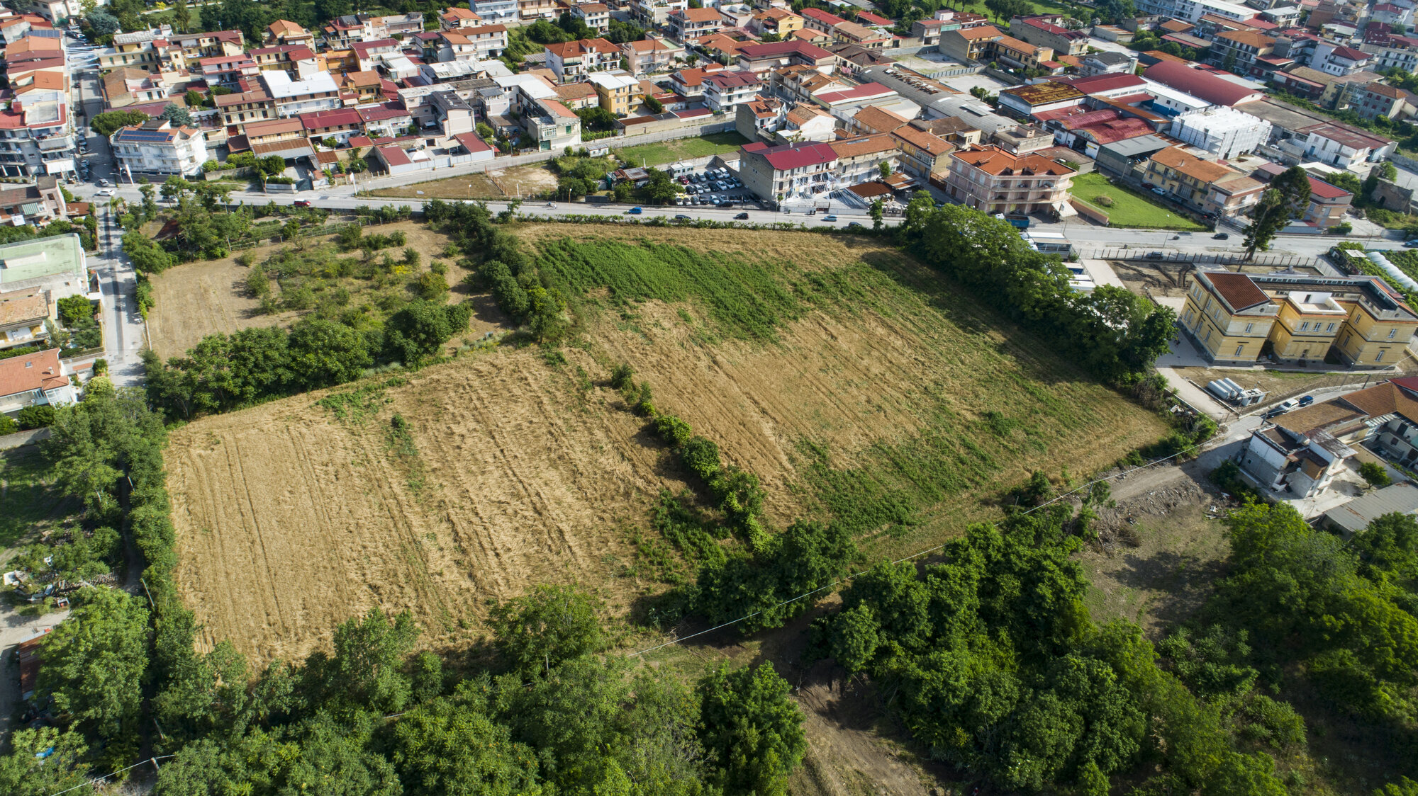
The modern town of Sant’Arpino is situated ca. 23 km to the south of Caserta and 30 km north of Naples, between the towns of Orta di Atella and Frattaminore, and joins with the town of Succivo: the archaeological area extends into the overlapping outskirts of these towns ( Figure. 3). The research area (5 hectares) extends into Sant’Arpino, divided by Via Luigi Compagnone, a road identified as the main decumanus of the Roman town (Bencivenga Trillmich 1984, with references). This sector of the site, the core of the archaeological park established in 2010, is currently partly used for the cultivation of wheat; the rest of the area, part of which was excavated by SABAP over a two-year period (2010-11), is covered by dense vegetation.
2. Archaeological setting
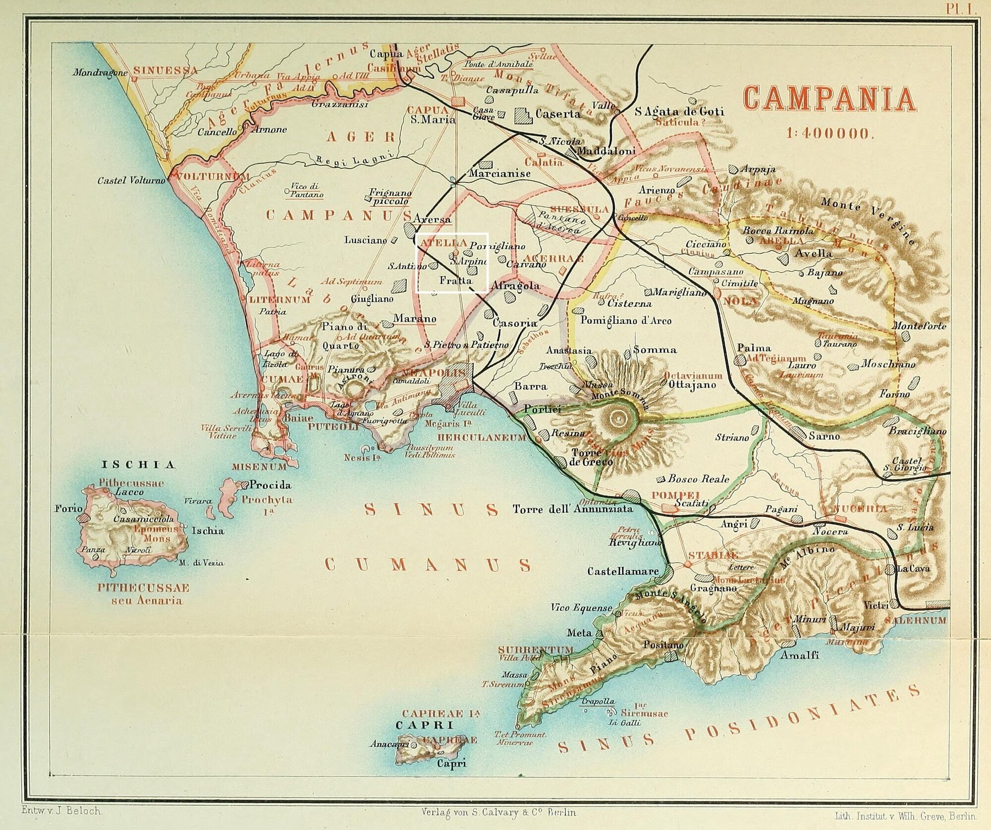
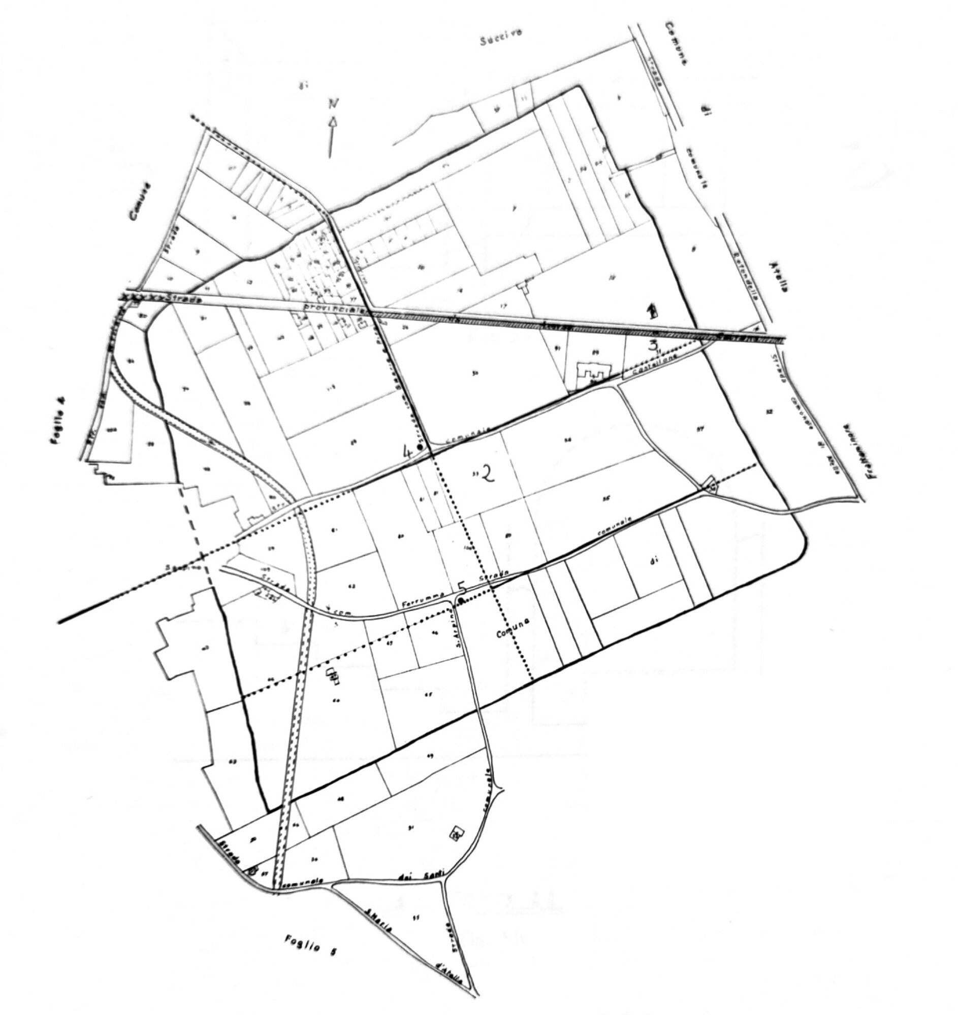
The location of Atella, an Oscan city which in antiquity gained fame through the “fabulae Atellanae”, has been known at least since the mid-18th century (cf. De Muro 1840; Beloch 1890; De Caro 2012; Laforgia 2007; 2014) (Figure. 4). At the beginning of the 20th century, the urban perimeter of the city was defined by Castaldi (1908). The archaeological map is an valuable representation of the site made when the main urban infrastructure (roads and city walls) were still visible (Figure. 5). Archaeological evidence suggests the city’s origins can be traced back to the end of the 5th century BC, and its urban development traced to throughout the 4th century BC (De Caro 2012, 87). Allied with Capua in response to the Roman expansion in the Campanian plain, after their defeat in 338 BC, Atella became a municipium, holding the status of civitas sine suffragio (Festus, 50.126). In 211 BC, the city lost autonomy and citizenship after siding with Hannibal in 216 BC (Laforgia 2007, 18). By the 1st century BC, Cicero’s writings indicate that Atella was recognized as a municipium with jurisdiction over an ager vectigalis (Cic., fam., 8.7). By the first half of the 1st century AD, Atella was likely equipped with the set of public buildings typical of a Roman city: a theatre must indeed have been a significant feature at the birthplace of the Atellan farces, although it is never mentioned by ancient sources; however, there is a reference to an amphitheatre by Suetonius (Tiberius, 3.75.3), in connection with the populace’s wish to burn the body of Tiberius, who died in Misenum (AD 37). In Late Antiquity, the city was destroyed by a fire (late 4th-early 5th century AD) but continued to prosper as an episcopal seat until at least the 7th century AD (cf. De Caro 2012, 88). During the Roman period, Atella was connected to the major cities of Campania through a series of roads, whose topography is strictly linked to the centuriation of the alluvial plain (Quilici Gigli 2002; 2005). Several elements remain allowing a discussion of the chronological evolution of Atella’s rural landscape and its relationship with the Ager Campanus following research conducted in the Acerra area (Giampaola 1997; 2002).
Nevertheless, the general urban evolution of Atella remains still largely undefined. The trapezoidal layout of the city is marked by large tuff block fortifications and a wide ditch, which date to the mid-4th to early 3rd century BC (Elia 1959; Johannowsky 1970, 1976; cf. Bencivenga Trillmich 1984, 6, n. 11). The city’s internal layout included a network of streets, among them three roads, one cardo and three decumani, as well as several narrower streets with a NW-SE orientation, differing from the Ager Campanus alignment (cf. Monaco 2004, fig. 7). The space between the decumani, of approximately 180m, features Roman measurements and above all a module of 60 repeated three times, perhaps a layout for scamna (Rescigno and Senatore 2010). The most visible remaining Roman building of Atella is the “Castellone”, part of the frigidarium of a monumental bath complex adorned with painted stuccos from the early 2nd century AD. Notable discoveries within the area also include 1st to 2nd century BC private houses with a peristyle (Johannowsky 1966, 1967; Matarese et al. 2023) (Figure. 6). Excavations of a bath complex were conducted between 2009-10 in an area probably close to that investigated in 1967, whose exact location is still uncertain. The structures correspond to only part of the entire complex, extending over an area of 1170 m2, along a NE/SW axis along. The bath may be referred to the canonical sequence which provided for the passage from cold rooms to gradually heated ones (De Caro 2012, 96). An analysis of the building technique and the stratigraphic data allowed the identification of three main phases, from the Republican to the Imperial period, with subsequent use up to the 5th century AD and an eventual abandonment between the 6th and early 7th centuries AD (cf. Arenella et al. 2015). Funerary contexts identified south of the city walls currently constitute the most significant archaeological evidence of the city’s life (Guzzo 2016, with references). Archaeological investigations have also brought to light tombs from the pre-Roman phase, some dating between the late 5th and early 4th centuries BC; however, most data pertain to the large necropolis of the 4th century BC (Bencivenga Trillmich 1984). Systematic archaeological investigations, conducted by SABAP between 1995-97 at Frattaminore (Orto dei Santi), revealed a sector of the southeastern necropolis: seventy-six tombs dating between the 1st and 4th centuries AD with differing orientations were investigated, although a majority were E-W oriented, consistent with the road axis that crossed the investigated area (De Caro, Guzzo, Tocco 1997, 815).
3. Research strategy and methods
The topographical integration of legacy data into archaeological mapping has been a widely discussed topic in archaeology over the past decades (cf. Brancato 2019, with references). The time-consuming interpretative process can no longer fully exploit the potential of purely noninvasive investigations by analyzing only surface records. As recently proposed by Launaro et al. (2023), the solution to this may lie in the combined application of both traditional and innovative topographic and archaeological methods, including field surveys, remote and proximal sensing, and large-scale geophysical prospection (cf. Scardozzi, Saponara, Masini 2007; Campana 2018). Indeed, the GIS platform is not just an ideal set for the digital palimpsest for this data visualization but also a dynamic environment that allows both new and legacy data to interact with each other (Bogdani 2019, with references). This approach is used for the reconstruction of the archaeological landscape of Atella, where 2D and 3D geospatial and archaeological documentation interact within the project’s geodatabase (Figure. 7).
As part of the project, archaeological legacy data from the 19th and 20th centuries were collected, in order to identify the provenience of excavated materials and improve the documentation of architectural elements at Atella. The digital data integration workflow defined for the project is a multilayered process that aims to enhance the archaeological investigation for understanding the site’s ancient urban layout, without the need for direct excavation (Abate et al. 2023; Dorninger and Nothegger 2012; Wang and Hu 2014; Tanasi et al. 2023). Therefore, together with the non-intrusive methods, the approach conforms to the so-called “Archaeology of Archaeology”, which was initially proposed by Murray and Spriggs Field (2017). This approach views a site as a laboratory where prolonged archaeological investigation produces data and knowledge while leaving physical evidence on the site.
The archival research carried out so far has generated a large amount of data (both raster and vector) on the dispersed archaeological heritage of Atella. The heterogeneous datasets serve as layers in the GIS platform, enabling geodata to interact with one another. These datasets are based on: (1) cartographic data from archives; (2) published reports of archaeological excavations and survey projects; (3) topographical data from the fieldwork undertaken for the georeferencing of legacy data in points 1 and 2; (4) topographical data from the geophysical prospection with the use of Ground Control Points (GCPs) measured with a GPS; (5) remotely sensed data, including satellite imagery, low‑altitude historical photographs from Royal Air Force (RAF), Military Aeronautics (AM), Istituto Geografico Militare (IGM); Italian National Geoportal, Bing Maps, Google Earth, LiDAR (TLS); (6) proximally sensed data, including UAV imagery, DTM models obtained through aerial Structure from Motion (SfM), multispectral imagery; (7) excavation data.
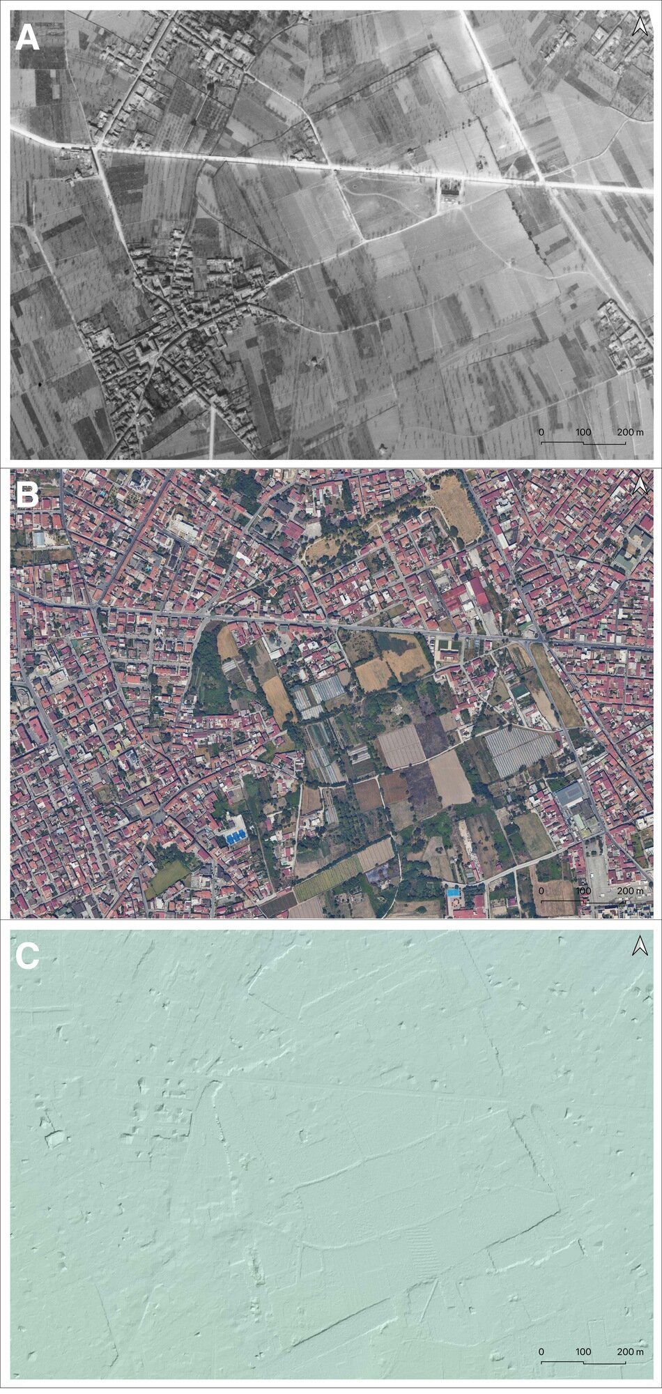
The multi-temporal raster dataset helps mitigate the biases that archaeological surveys might face when relying on a single method. As with other Mediterranean regions, in the second half of the 20th century Campania was heavily modified by large infrastructure and building expansion, and many archaeological elements of the landscape have therefore been erased (Figure. 8). For example, the analysis of historical aerial photographs (Guaitoli 2003), compared to satellite images, in the case of Atella constitutes an essential asset of the research aimed at reconstructing the urban form of the city and its territory (Carfora 2011; cf. Quilici Gigli 2005). However, a biased analysis can arise from the randomness and seasonality of traces, which often have a short duration; indeed, for remotely and proximally sensed data, images taken in different years and at different times of the year, increase the chances of detecting traces of buried archaeological features (cf. Brancato, Barone, and Scardozzi 2023 for more). The diachronic analysis of these images is facilitated by their georeferencing and integration into GIS platforms, which create a virtual environment where remotely sensed data is combined with archaeological and geophysical data.
Indeed, topographic surveys in the field are also required to record relevant information concerning the site’s archaeological potential. The ground surface may contain important information about the nature of an archaeological site, either related to the potential existence of structures buried beneath the soil (Bowden 1999) or to the taphonomic processes associated with its origin (Quilici Gigli 2002). This is the case of Atella, whose Roman urban grid partially survived embedded in the contemporary landscape. However, radical changes also occurred in its topography which have a great influence on determining the nature of features to be checked through a non-invasive survey (Figure. 9). Therefore, the first step is the detailed topographic survey of the site for recording elevations and relevant points along known breaks in slope; on the basis of these fixed GCPs, corresponding to locations on the digital map, the second step is the creation – in the GIS - of a grid of the entire area. Geodata at different scales are collected to generate three-dimensional and two-dimensional models. This process, which uses Structure from Motion (SfM), enables the extraction of orthophotos and sections from the resulting Digital Elevation Models (DEMs) (cf. Bezzi et al. 2010; Naso et al. 2024). Extensive and intensive topographical surveys, geophysical prospections, surface sherd collection, pedological soil sampling, and test trench excavations are crucial in the project’s strategy. However, it is necessary that the execution plans and the results are designed to align with the same grid system.
4. Geophysical prospection
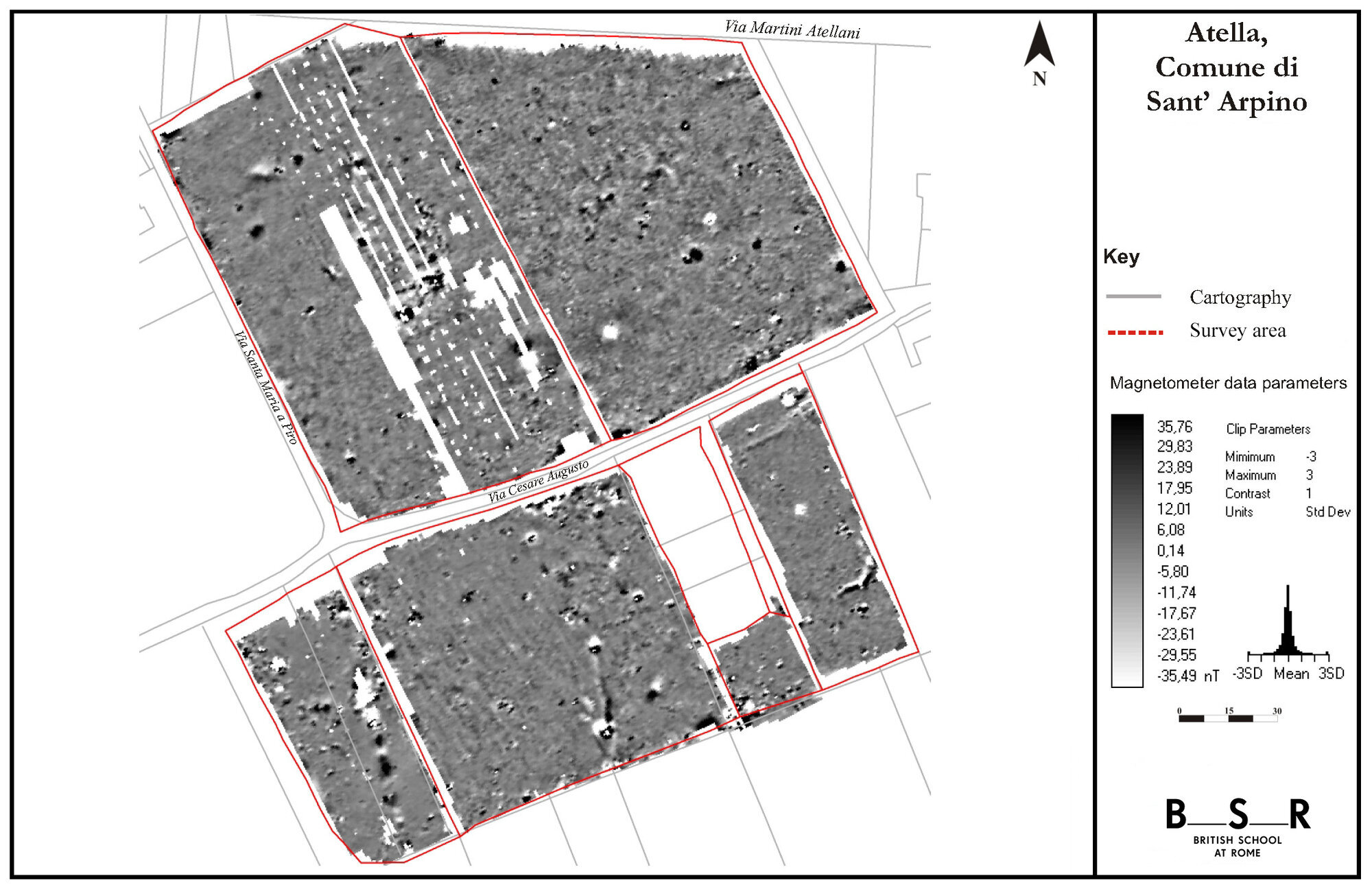
A number of different geophysical survey techniques can be applied by archaeologists to record the remains of sub-surface archaeological structures. The most commonly applied geophysical techniques include magnetometry and Ground-Penetrating Radar (GPR) (Gaffney et al. 2003; Jol 2009). The choice of prospecting methods is determined on the basis of the extent and nature of presumed sub surface archaeological structures, remains and features (for the methods cf. Non-Intrusive Methodologies for Large Area Urban Research) and the local soil morphology and geology. Magnetometry survey is generally chosen as a relatively timesaving 1 and efficient extensive survey technique (Gaffney et al. 1991: 6), suitable for detecting minor changes in the earths magnetic field, and is therefore particularly suitable for locating kilns, hearths, ovens, ditches and walls, especially where ceramic material or tufa have been used in construction (Gaffney et al. 1991: 6; Scollar et al. 1990: 362) and is therefore particularly suitable for the investigation of a Roman town (Kay et al 2023). In areas of modern disturbance however, the technique is limited due to disturbance by modern ferrous material. GPR is a high-resolution geophysical technique traditionally employed in archaeology for the detailed investigation of restricted areas (Jol 2009). This method utilizes electromagnetic waves to detect and map subsurface features and anomalies. Measuring the strength and time delay of the responses it is possible to estimate the depth of the sub-surface features. Recent work has demonstrated the value of GPR for the investigation of Roman urban sites: since 2015, the GPR has been used on a large scale to generate high-resolution datasets of two greenfield sites in Lazio, Falerii Novi and Interamna Lirenas. Although such rapid data collection allows the mapping of entire Roman towns at an unprecedented level of detail, interpretation of these datasets still largely relies on expert visual interpretation and the manual digitization of anomalies.The magnetometry survey at Atella, undertaken by the BSR, was conducted in 2006 since when there have been significant developments in terms of sample resolution and efficiency with the advent of multi-sensor cart configurations (Figure. 10).
The decision to use magnetometry was guided by the previous successful application of this technique by teams from the BSR and University of Southampton at the nearby Roman towns of Teano (Hay et al. 2006) and Calatia (cf. Campana 2021). At Atella, an area of approximately 4 hectares was investigated. The presence of a high quantity of metal, such as that used in fences, pipelines and greenhouses may have had the effect of masking the more subtle magnetic fields of archaeological features (cf. Geoscan Research 1996).
The geophysical survey used grids of 30m by 30m, which were set out using a Total Station. In optimal conditions the grids would be oriented to ensure that the survey crossed the line of potential archaeological features at a 30° angle; however, the significant restrictions imposed by the vegetation across the site meant that the survey grid was established in an approximate north - south direction, in line with the majority of the vegetation. The geophysics was spatially located through a topographical survey for accurately mapping the geophysical survey with the available cartography. The magnetometer survey was undertaken using a Geoscan Research FM36 Fluxgate Gradiometer. Readings were taken at 0.5m intervals along traverses every 1m. An automatic encoder trigger was used to take the readings, allowing the survey to take place more rapidly in areas relatively free of obstructions. However, in the areas of dense vegetation, in particular area 30 (Fig. 14), it was necessary to use the manual logger to collect the readings.
The geophysical survey at the site of Atella presented a series of problems for the magnetometer survey, and these are reflected in the results (Figure. 11 - Figure. 12). The modern interference caused by metallic fences, discarded material and overgrown vegetation has the effect of potentially concealing archaeological features which have a weaker magnetic field. However, the background geology of the site, whilst undoubtedly contributing to the masking of some features due to its volcanic nature, was generally quiet which has aided in identifying some archaeological features. Therefore, the survey successfully located features related to aspects of the urban topography of the ancient Roman city.
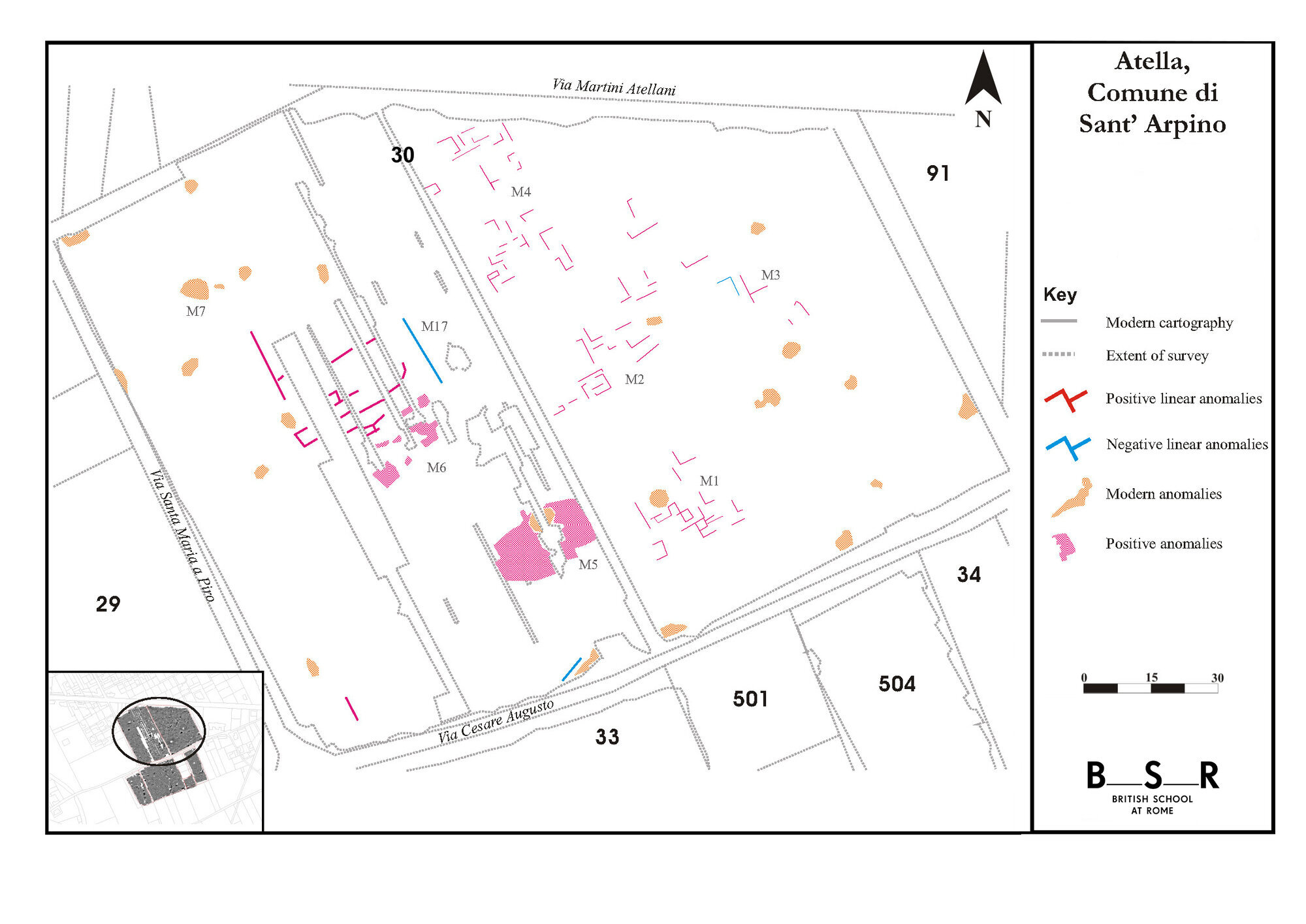
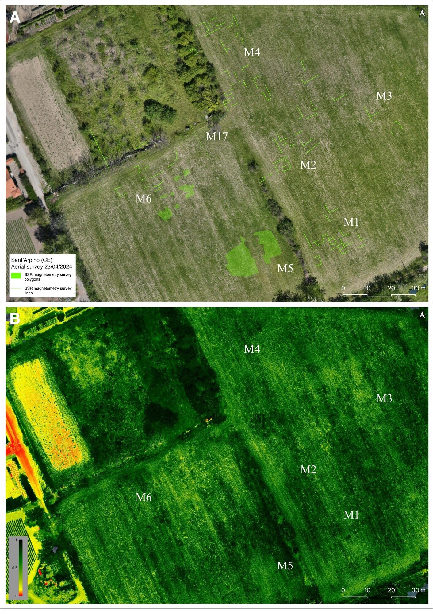
In the northern part of the survey, to the south of Via Martiri Atellani, several positive anomalies were recorded which would appear to relate to a series of walls (M1, Fig. 11). Whilst there are no clearly distinguishable rooms visible, it would appear that the walls relate to a building. Further northwards were located a further series of positive linear anomalies (M2, Fig. 11) which can be interpreted as walls. Whilst it is not possible to identify precise function, it should be noted that the anomalies lie on the same alignment as those to the south [M1] as well as those further to the north (M4, Fig. 11). Furthermore, the orientation of these features also appears to correspond to the known direction of the main cardo and decumanus of the city. As with the general layout of the site, illustrated by Bencivenga Trillmich (1984), the features are orientated on a north westerly south easterly axis, parallel and horizontal to the known urban plan (Fig. 6). To the east, fewer archaeological anomalies were identified, possibly due to the effect of data collection in high vegetation. However, traces of some positive and negative features were recorded by the survey (M3, Fig. 11). The features show clear right angles, a strong indication of the presence of buried walls.
In the western sector of area 30 a series of archaeological features were identified (M5, M6 and M7, Fig. 11). The positive anomaly (M5, Fig. 11) towards the southern end of area 30 is slightly masked by the presence of modern rubbish towards the centre. However, this appears to be the location of a sizable structure; the complete feature is roughly oval in shape and measures approximately 18 m in length by 12m. Within the general feature there appear to be some radiating anomalies, however the effect of the modern debris has masked many of the more ephemeral features.
A further series of archaeological anomalies as well as some general linear features, both positive and negative were recorded in the middle of the study area. The features have been distorted by the interruption caused by the vegetation but appear to lie on a similar orientation to those identified in the eastern part end of the field (M1 4, Fig. 11). Further northwards lies an area of modern disturbance (M7, Fig. 11) whose recorded readings were however significantly lower than those expected of modern debris. It is possible that this is the location of an earlier investigation that apparently located the presence of a buried tomb.
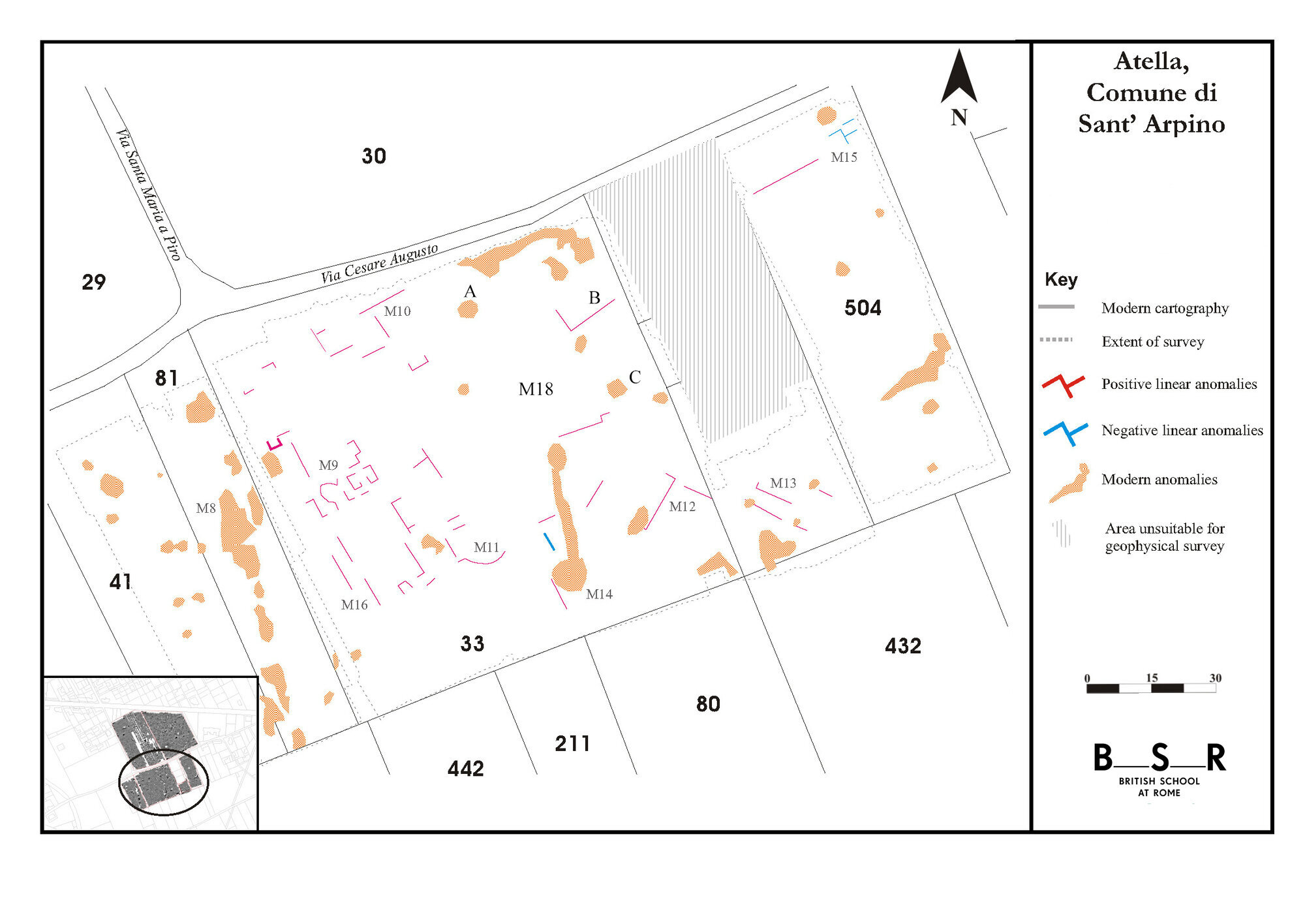
The western section of the southern field corresponds to the area where Johannowsky conducted an excavation in the mid 1960’s and discovered a private building, as well as part of a bath complex. The survey was successful in mapping a number of these walls (M9, Fig. 12), however it is clear that not all were detected by the magnetometry. The excavated area was likely to have been backfilled after the excavation or covered over a period of time (§ Discussion). This modern disturbance may have masked some of the weaker archaeological features. However, some of the features recorded appear to correspond to those seen by Johannowsky, in particular the apsidal feature which would appear to correspond to a part of the bath complex (M9, Fig. 12).
Towards the northern edge of the survey in area 33 were recorded a further series of positive linear anomalies (M10, Fig. 12). These features would appear to be on the same alignment as the general urban grid. Also apparent in this area are a series of faint negative modern anomalies that run in an approximate north south direction. These are modern traces of the poly tunnels constructed from metal support arcs which were removed the day before the area was surveyed and therefore reflect the depressions left in the soil by the space between the tunnels.
To the southern end of the survey area, still within a central area of the city, were recorded a series of positive anomalies (M11 in Fig. 12) which appear to correspond to archaeological features. In particular, clearly evident is a further apsidal feature, associated to a series of interlinking walls. The features recorded to the east of this area, beyond the area seemingly investigated by Johannowsky, lie a series of features (M12 – M13 in Fig. 12) on a different alignment to the others (M9 – M11 in Fig. 12). Whilst it is not possible to identify the function of these features, it is possible that these may relate to a different phase of activity on the site.
Within area 504 several features were identified, both positive and negative (M15, Fig. 12) as well as several modern anomalies. These appear on the same alignment as those further to the west and lie parallel to the decumanus, approximately 5–10 m to its south.
The modern disturbance across the site presented some problems for the magnetometer survey and the subsequent interpretation of the results. However, there is clearly evidence for a series of buried structures across the survey area, which when combined, begin to form a picture of the urban layout of the town.
The northern area of the survey (Fig. 11) illustrates the complexity of the underlying archaeology, in particular (M4, Fig. 11) which recorded a range of different features. Furthermore, several different features lay on a differing orientation to the other identified positive anomalies, which may therefore indicate a different phase of activity on the site (M13, Fig. 12).
In conclusion, the magnetometry successfully mapped a series of structures and anomalies that would appear to be associated with the ancient town. The majority of these features appear to lie either parallel or perpendicular to the known road system within the city, and thus conforming to the presumed settlement layout. Despite the aforementioned problems (i.e. interference by highly magnetic structures and debris, as well as the overgrown vegetation), the survey did successful identify a range of features which will help to broaden the knowledge of the plan of this ancient city.
5. 2023 field survey and proximal sensing application
The archaeological research project at the site began in June 2022 with a field survey of the area. Through the integrated use of a Total Station Leica TS03 5” R500 and a GPS Antenna Leica Zeno FLX100, elevations and relevant points along were measured. The grids (10 by 10 m) created in the GIS platform in WGS 84 UTM Zone 33N (EPSG 32632) - was transposed to the field with a series of fixed GCPs corresponding to locations on the digital map (cf. Brancato et al. 2023).
The site’s geomorphology is characterized by a wide, flat terrace elevated on the Campanian plain, formed by a sequence of volcanic soils and tufa, upon which the urban landscape of Atella was shaped (cf. Di Vito et al. 2021). However, in the last century, the agrarian landscape, still testified in a 19th century description of the area (e.g. Beloch 1890 and Castaldi 1908), was re-shaped by the urban expansion, which dramatically intensified in the entire area after the Second World War (Fig. 8). Other recent changes could clearly be deduced also from a comparison between historical cartography and the remotely sensed data. Due to the urban expansion that has occurred at the archaeological site, mainly in its northern sector, coupled with the dense vegetation coverage which affect the central and southern parts, a survey approach was imperative for undertaking the planned activities (Figure. 13).
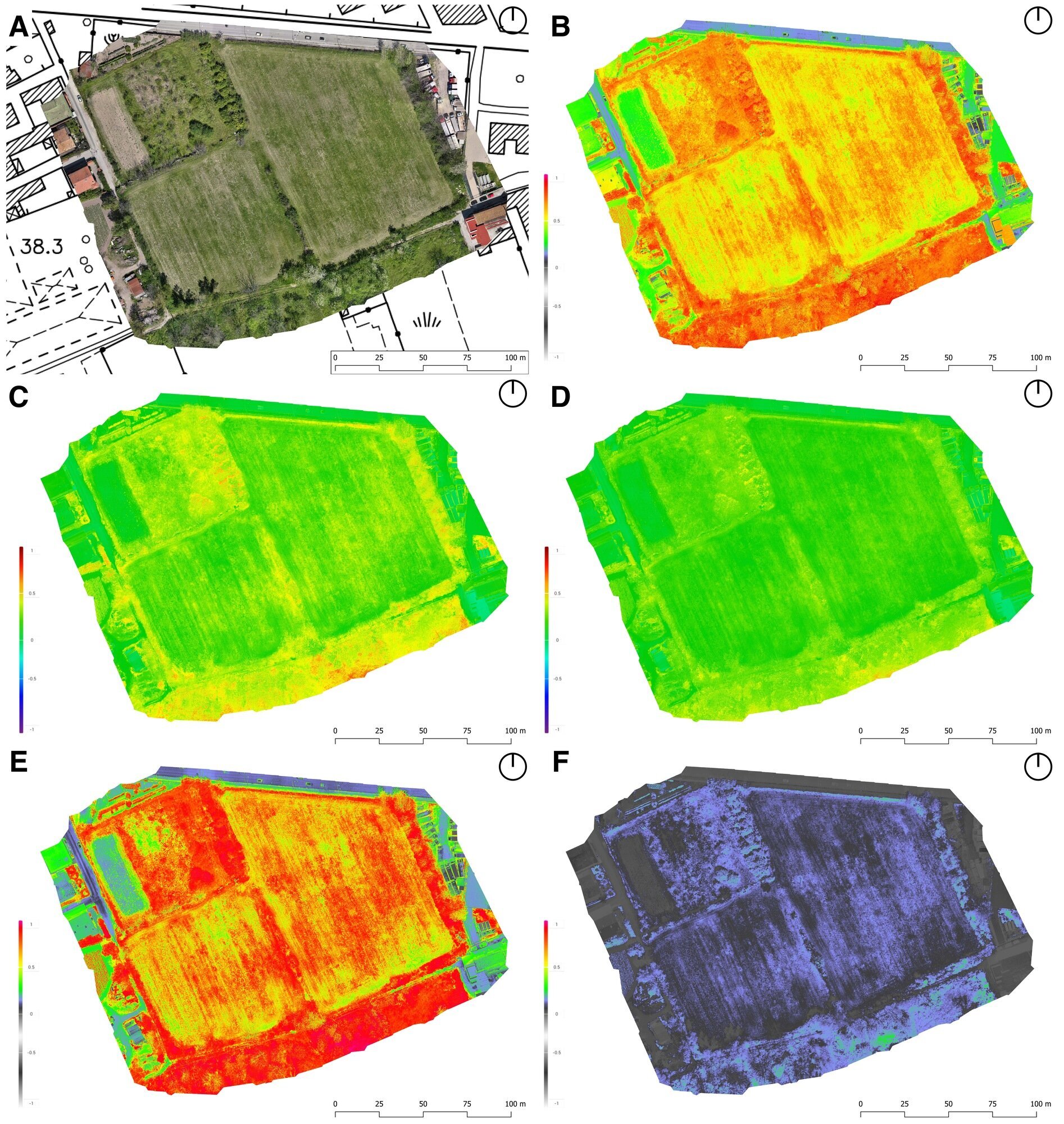
In 2022-23, a topographical survey was conducted of the entire area (5 hectares): 1) instrument relief survey; 2) field survey; 3) close-range remote sensing and proximally sensed data, using a drone equipped with RGB and multispectral cameras 2 (Figure. 14). Instrumental surveying was applied to capture key topographic points essential for the multiscale cartographic documentation of the site. The instrumental survey was established using a closed-type topographic polygon, a choice made despite visibility challenges caused by the dense vegetation in the southern sectors of the site (nos. 40, 41, 81, 33, 501-3 in Fig. 9). The measurements were designed to produce high-resolution digital cartography for the entire site (geometric model) and to provide a topographical platform for 3D models, addressing the needs of research, conservation, and enhancement within cultural heritage studies (cf. Lock 2003; Moscati 2009; Ferdani et al. 2019). The 3D spatial data, derived from SfM processing created with Agisoft Metashape, were integrated in Leica Cyclone (cf. Brancato in Naso et al. 2023): this was possible through the identification of GCPs utilized for the placement of a total station and measured with a GNSS antenna. Based on the same GCPs, through the “Georeferencing” plugin available in the cartographic software QGIS, each raster file was a layer of the GIS platform and used for the creation of vectors.
Commenced in 2022 and still ongoing, the intensive and systematic surface survey (60 hectares) was based on the10m by 10m grid plotted in the GIS: teams using portable GIS on tablets (QFields software) surveyed the squares arranged in transects with a constant distance (2 m) (Fig. 9). In agreement with the SABAP, a total collection of visible archaeological artifacts on the surface was undertaken. Although preliminary, the survey of the central area has yielded significant results: material found in the topographical unit (UT) 30, which had the best visibility since it was surveyed immediately after ploughing, ranges from the Republican period to the modern age, with interesting evidence for the early medieval period (Figure. 15).
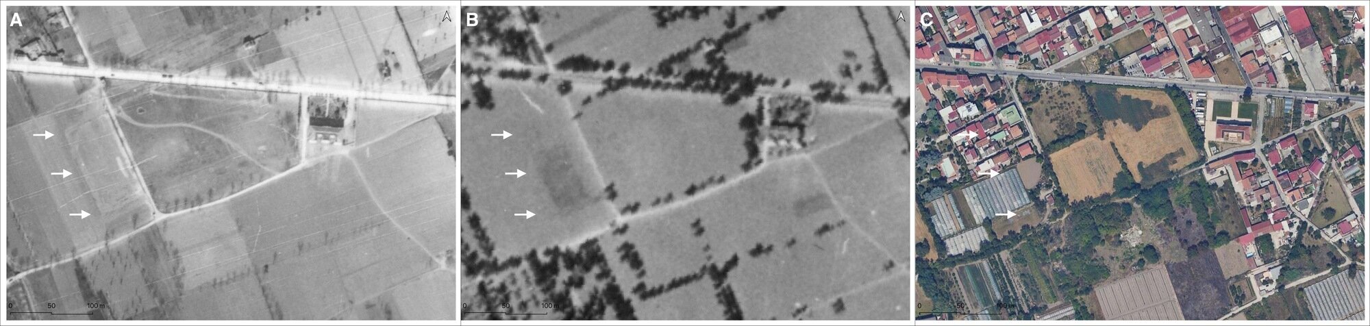
The aerial survey of the central area (6.7 hectares) was carried out through the systematic use of a drone (Figure. 16). The obtained proximally sensed data were used for the creation of an ultra-high-definition digital model (1.2 cm per pixel), from which it is possible to extract not only orthophoto plans but also an updated topographic base with 10 cm contour lines. Thanks to the combined application of RGB and multispectral cameras, the orthophoto plans can be analyzed sequentially to check the topographic consistency of cropmarks visible in the cultivated sector of the archaeological part; in the southern sector, the dense tree vegetation and the greenhouses prevent the use of the multispectral sensor. However, good results were obtained from the aerial survey conducted in early May 2024 over the central area (2.5 hectares) north of Via Martiri Atellani, when the grain was almost at the end of its growth cycle (n. 30 in Fig. 9). Here, intricate chromatic anomalies are visible, some of which are likely related to buried buildings, at least in the case of a long linear feature (M1 in Fig. 16 B).
6. Discussion
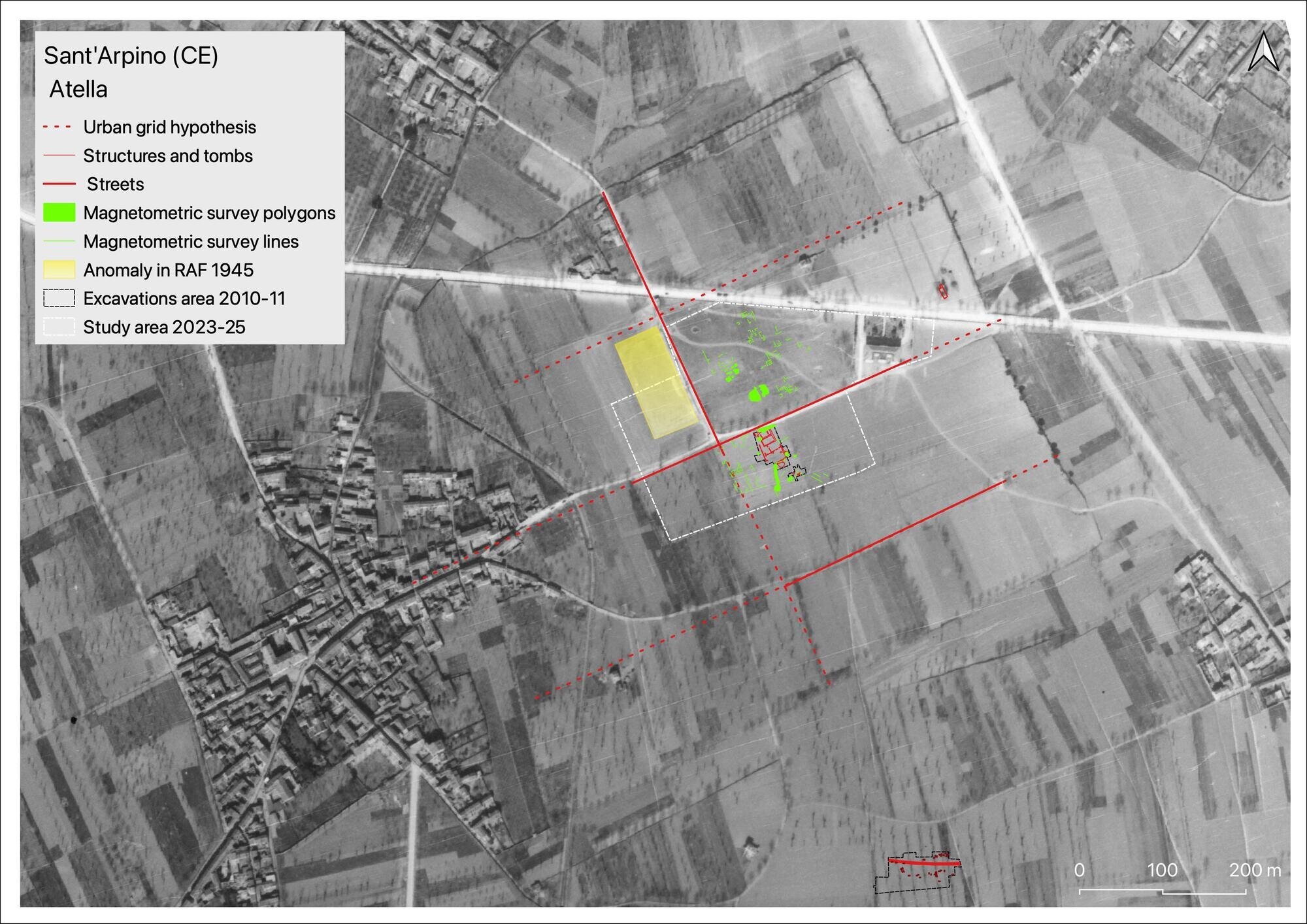
The visible archaeological structures, together with the data from the magnetometry and the remotely to proximally sensed data, may help in the reconstruction of the urban plan of Atella. Only two flights were undertaken in 1943 and 1945 by the RAF on this area: however, in the frames, traces of a large rectangular anomaly, about 52m wide and elongated in a NW-SE direction for about 113m, is clearly visible in the 1945 aerial photograph (flight 930 of March 10, 1945; strip: 3402; frame: 3073) and in the VB by IGM (1954) (Figure. 17) (cf. Brancato, Barone Scardozzi 2023). This is in the central area of the ancient town, near the place where the main cardo and decumanus likely intersect: with an orientation consistent with that of the urban layout, the anomaly may refer to the perimeter of a large building or perhaps a large paved open space. Moreover, also a chromatic anomaly could be substantiated by a structure which was plotted in the archaeological map published by Castaldi (Fig. 5, n. 3). Indeed, based on the GIS, this anomaly should be in area 30 and may correspond to a wall (5 m) (Castaldi 1908, fig. 1, n. 8). Its description consists of height measurements relative to the ground level (maximum height: 2.13 m) with opus latericium superimposed on a structure in opus reticulatum) (Castaldi 1908, 81): the level of detail may allow for the hypothesis that the structure could be attributed to a multi-phase construction, perhaps a monumental portico located on the eastern side of the forum. The west sector of the field was covered by the magnetometry survey conducted in 2007, and aerial survey with multispectral sensor in 2023. The positive anomalies M5 and M6 from magnetometry can be compared with proximally sensed data (Fig. 16). Indeed, in both panchromatic and multispectral aerial footage filtered with the NDVI index, significant anomalies are visible that are consistent with those identified by geophysical surveys and, in some cases, comparable to buried buildings (cf. Agapiou et al. 2012).
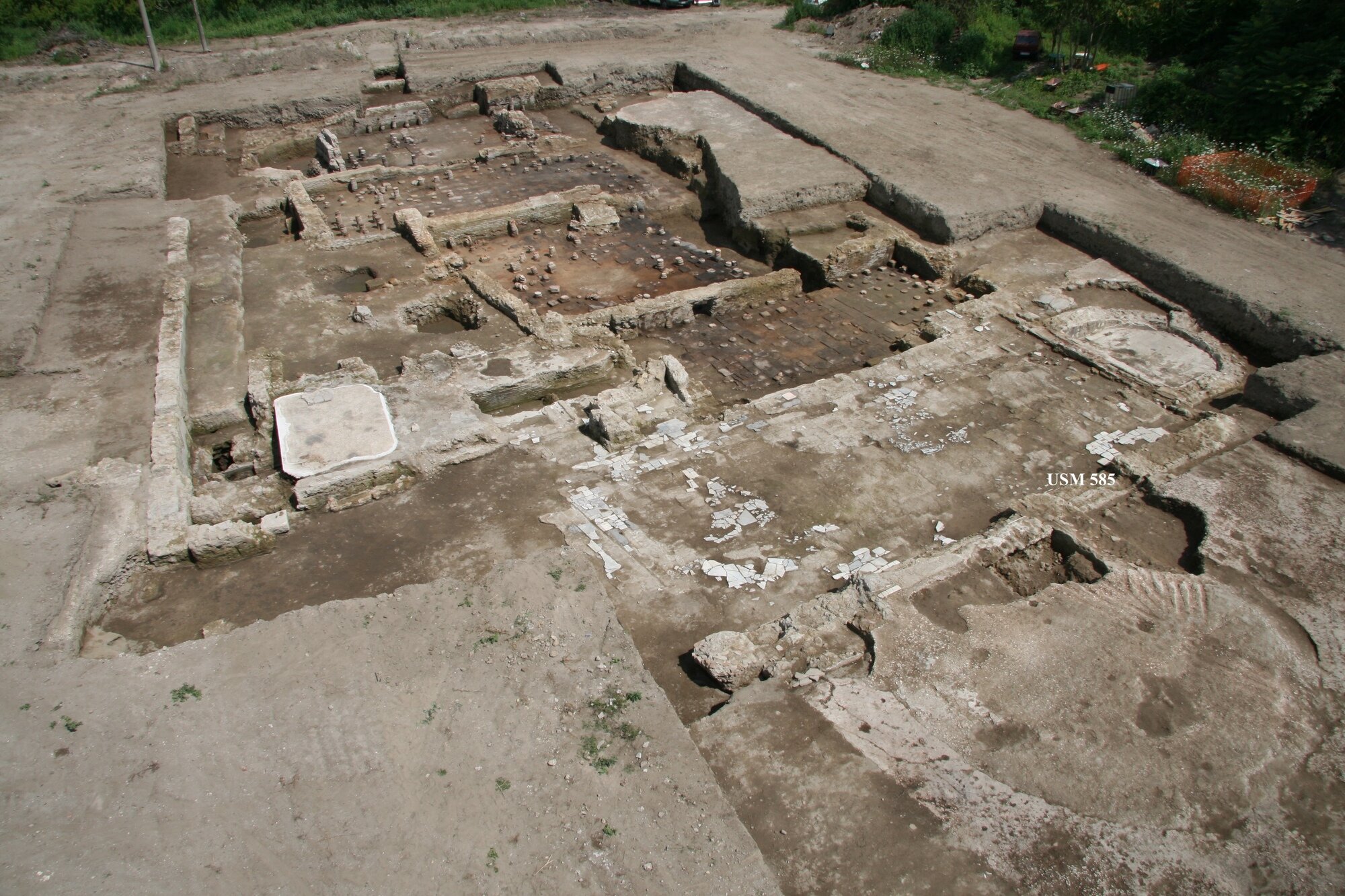
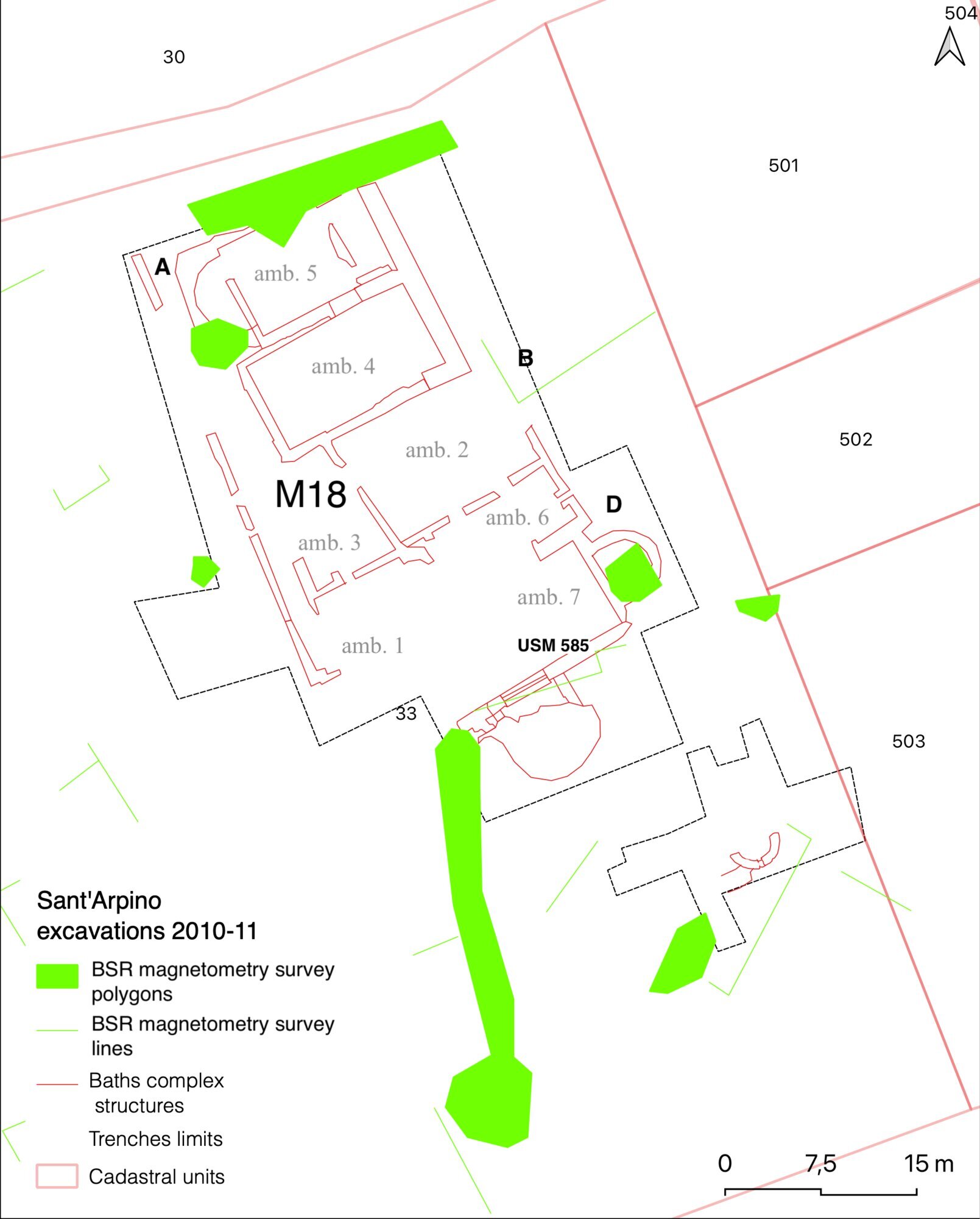
The results from the magnetometry survey conducted in 2006 can be compared also with the structures brought to light in the 2010-11 excavations. Indeed, the placement of the excavation was likely based on visible wall crests on the surface (38.68 m a.s.l.), without necessarily considering the results of the magnetic survey (Figure. 18). Specifically, in that sector, a series of anomalies emerged, particularly two linear features with an east-west orientation and small areas of higher readings, identified as potentially modern fills. Therefore, it is of particular interest to note that M18 (Figure. 19) constituted the bulk of a significantly thick wall partition (USM 585, 37.86 m a.s.l.), attributable to the south perimeter wall (cf. Figs. 12 and 19). constituted the bulk of a significantly thick wall partition (USM 585, 37.86 m a.s.l.), attributable to the south perimeter wall (cf. Figs 12 and 19). The lack of visibility of anomalies related to structures buried deeper than 0.82 meters from the ground level is certainly significant in light of the excavation results; the areas identified as modern anomalies are likely related to the fills of the pools of the frigidarium (C in Fig. 19) and the calidarium (A in Fig. 19).
This case emphasizes the importance of integrating different archaeological methodological approaches, particularly between geophysical surveys, like magnetometry, and traditional archaeological excavations. The cited example highlights how, in some cases, decisions regarding the location of excavations can be influenced by surface observations, such as visible wall tops, without adequately referencing data provided by pre-excavation geophysical surveys. This may lead to underestimating or even overlooking crucial information about the presence of structures buried at greater depths. The mention of linear anomalies with an E-W orientation and small pockets of higher readings interpreted as modern fill illustrates the complexity of interpreting geophysical data and the need for careful integrated analysis to distinguish between ancient structures and more recent interventions. Moreover, the discovery of a significantly thick partition wall and the potential identification of structures from the thermal complex underscore how geophysical surveys can provide valuable information to guide and optimize archaeological excavations. The use of GIS technologies for overlaying and analyzing geophysical data with excavation results and other ground investigations allows for a deeper understanding of the archaeological site and facilitates the reconstruction of ancient structural complexes. In this specific case, the confirmation through GPR survey of the presence of buried structures at a certain depth adds another layer of information, supporting the hypothesis of structures belonging to the thermal complex and potentially indicating new areas of interest for future investigations.
7. Conclusion
In summary, the multidisciplinary approach not only improves the precision and effectiveness of archaeological research but also opens new perspectives on understanding ancient urban sites, allowing for more informed hypotheses on their spatial and functional organization. The workflow applied in the first steps of the Atella Archaeological project, integrating data from different scales, sources and technologies, including aerial photography, satellite imagery, geophysical prospection and field survey aims to provide a detailed understanding of the archaeology topography of the site (Figure. 20). The connection between the thermal complex investigated in 2010-11 by SABAP and the forum, as suggested by Camodeca (2021) through an insightful analysis of the epigraphic material, is a hypothesis now supported also by the integrated reading of legacy geodata and remotely sensed images. Indeed, the digital topographic palimpsest, inferred from the informed layering of anomalies derived from geophysical prospection and the recovery of topographical evidence from digitized and georeferenced legacy data, allows for the hypothesis that the project’s focus area is the central part of Atella, where the main public buildings were located (Gros, Torelli 1988). Future research on such a crucial sector of the ancient city may not only provide significant insights into the urban planning and architectural development of Atella through the centuries, but it can also highlight the importance of integrating various methodologies in archaeological research. Indeed, the combination of extensive geophysical surveys and photointerpretation may offer a glimpse into the spatial and functional topographical organization of a Roman town, as outlined in the discussion of the 2006 magnetometry survey results. Through an integrated approach, hypotheses about the urban layout and functional areas of ancient urban centers are possible, but they must be substantiated. In the case of the Atella Archaeological Project, the planned targeted excavations in the next years (2024-26) will clarify the stratigraphic relationships between the elements of the digital GIS palimpsest.
Acknowledgments
The research is part of the project “In.Res.Agri - Investigating Resilient Roman Agricultural Landscapes in Southern Italy. An Integrated and Open IT Approach to Modelling Centuriation through Archaeology, Remotely Sensed Data, Palynology and Ancient Texts” funded by the European Union – NextGenerationEU – “Fondo per il Programma Nazionale di Ricerca e Progetti di Rilevante Interesse Nazionale (PRIN) – Project Code 2022SMJCHX, CUP: B53D23001910006.
Footnotes
- The magnetometry survey at Atella was conducted in 2006 when the technique was the most widely used due to its efficiency in covering large areas. More recently, towed multi‑channel GPR configurations have enabled similarly sized areas to be investigated.
- The DJI Mavic 3 is a drone equipped with a two‑in‑one system which integrates a multispectral camera featuring four 5 MP lens, and an RGB camera equipped with a 4/3‑in CMOS and a 20 MP image sensor.
References
- Abate, N., D. Ronchi, V. Vitale, N. Masini, A. Angelini, F. Giuri, A. Minervino Amodio, A.M. Gennaro, and D. Ferdani, 2023. “Integrated Close Range Remote Sensing Techniques for Detecting, Documenting, and Interpreting Lost Medieval Settlements under Canopy: The Case of Altanum (RC, Italy).” Land 12 (2), 310. https://doi.org/10.3390/land12020310.
- Agapiou, A., D.G. Hadjimitsis, A. Georgopoulos, A. Sarris, D.D. Alexakis. 2012. “Towards an archaeological index: Identification of the spectral regions of stress vegetation due to buried archaeological remains.” In Progress in Cultural Heritage Preservation. Proceedings of the 4th International Conference, EuroMed 2012 (Limassol 2012), edited by M. Ioannides, D. Fritsch, J. Leissner, R. Davies, et al.: 29–138. Heidelberg, Springer.
- Arenella, A., S. Di Mauro, L. Lombardi, M.L. Perrone, and G. Soricelli, 2015. “Nuovi interventi di scavo nell’area urbana di Atella (Sant’Arpino, Caserta).” In Atti del Convegno di studi Insediamenti tardoantichi e medievali lungo l’Appia e la Traiana... Napoli: Tavolario Edizioni: 303–314.
- Beloch, J.K. 1890. Campanien. Breslavia: Bibliopolis.
- Bencivenga Trillmich, C. 1984. “Risultati delle più recenti indagini archeologiche nell’area della città di Atella.” RendNap 59: 3–26.
- Bogdani, J. 2019. Archeologia e tecnologie di rete: metodi strumenti e risorse digitali. Rome: Bradypus.
- Bowden, M. 1999. Unravelling the landscape: an inquisitive approach to archaeology. Stroud: Tempus.
- Brancato, R. 2019. “How to access ancient landscapes? Field survey and legacy data integration for research on Greek and Roman settlement patterns in Eastern Sicily.” Groma 15(1): 1–36.
- Brancato, R., P.M. Barone, G. Scardozzi, 2023. “Non-invasive archaeological research in Atella (Sant’Arpino-Campania, Italy). Preliminary results from the 2023 campaign.” Cronache di Archeologia 42: 397–417.
- Breglia, L. 1948. “La monetazione di Capua e il problema del denarius.” Numismatica XIV, 1–3: 11–16.
- Carfora, P. 2011. “Apporti dell’aerofotointerpretazione ad aspetti della viabilità in Campania: dati preliminari.” Archeologia Aerea 4/5: 353–354.
- Camodeca, G. 2021. “Nuove iscrizioni da Beneventum, Nuceria Alfaterna e Atella”. Epigraphica 83 (1–2): 45–56.
- Campana, S.R.L., 2018. Mapping the Archaeological Continuum: Filling ‘Empty’ Mediterranean Landscapes. Cham: Springer.
- Campana, S.R.L., 2020–2021. “Archaeology of former and historical urban landscapes in the Mediterranean world: current trends and future perspectives.” In Archaeology in the city... Pozzuoli: Naus Editoria: 31–49.
- Capasso, S. 1997. Gli Osci nella Campania antica. Aversa: Istituto di Studi Atellani.
- Castaldi, G. 1908. “Questioni di topografia storica della Campania.” Atti dell’Accademia Pontaniana XXV, II: 63–93.
- Chouquer, G., M. Clavel-Lévêque, F. Favory, and J.-P. Vallat, 1987. Structures agraires en Italie centro-méridionale. Rome: École Française de Rome.
- Clark, A. 1996. Seeing beneath the soil: Prospecting methods in Archaeology (2nd ed.). London: Batsford.
- De Caro, S. 2012. La terra nera degli antichi Campani. Napoli: Arte’m.
- De Caro, S., P.G. Guzzo, G. Tocco Sciarelli, 1997. “Le rassegne archeologiche. La Campania.” In Confini e frontiera nella grecità d’Occidente... Taranto: 791–870.
- De Franciscis, A. 1945. “Agro Atellano. Ritrovamenti vari”. Notizie scavi di antichità V–VI: 127.
- De Franciscis, A. 1967. “L’attività archeologica nelle province di Napoli e Caserta.” In Convegno di studi sulla Magna Grecia: 223–234.
- Di Vito, M.A., P. Aurino, G. Boenzi, E. Laforgia, and I. Rucco, 2021. “Human communities living in the central Campania Plain during eruptions of Vesuvius and Campi Flegrei.” Annals of Geophysics 64, 5, VO546; doi:10.4401/ag-8708.
- Dorninger, P. and C. Nothegger, 2012. “Multipurpose application of digital excavation data.” In CHNT 2017: 1–9. Vienna.
- Elia, O. 1931a. “Necropoli pre-romana.” Notizie scavi di antichità 10: 11–12.
- Elia, O. 1931b. “L’Ipogeo di Caivano”, Mon. Ant. Lincei XXXIV, IX: 424.
- Fitton, T., F. Sulas, M. Lisowski, M. Alexander, A. Juma, and S. Wynne-Jones, 2022. “Integrating spatial and legacy data to understand archaeological sites in their landscape.” Archaeological Prospection: 1–24. https://doi.org/10.1002/arp.1885.
- Gaffney, C. and J. Gater, 2003. Revealing the buried past. Geophysics for archaeologists. Stroud: Tempus.
- Gaffney, C., J. Gater, and S. Ovendon, 1991. The use of geophysical survey techniques in archaeological evaluations. Reading: IFA Technical Paper No. 9.
- Geoscan Research 1996. Fluxgate Gradiometer: Instruction Manual Version 1.2.
- Giampaola, D. 1997. “Appunti per la storia del paesaggio agrario di Acerra”. In Uomo, Acqua e Paesaggio: 225–238. Roma: L’Erma.
- Giampaola, D. 2002. “Un territorio per due città: Suessula e Acerra”, in Ager Campanus: 165–190. Napoli: Jovene.
- Guaitoli, M. (ed.), 2003. Lo sguardo di Icaro. Roma: Campisano.
- Guzzo, P.G. 2016. “Un corredo di età repubblicana dalla necropoli di Atella.” In Le regole del gioco: 283–291. Roma: Quasar.
- Hay, S., S. Keay, and M. Millett, 2012. “Teano (Teanum Sidicinum), Campania.” In Urban landscape survey in Italy and the Mediterranean, 105–113. Oxford: Oxbow.
- Haynes, I., T. Ravasi, S. Kay, S. Piro and P. Liverani, 2023. Non-intrusive methodologies for large area urban research. Oxford: Archaeopress.
- Hülsen, C.K.F, 1803. “Atella.” In Pauly-Wissowa, II: col. 1913.
- Johannowsky, W.B., 1966. “Atella.” Fasti Archeologici XXI, n. 2365: 167.
- Johannowsky, W.B., 1976. “Atella.” The Princeton Encyclopedia of Classical Sites: 106.
- Jol, H.M. 2009. Ground Penetrating Radar Theory and Applications. Amsterdam: Elsevier.
- Kay, S., S. Hay and C. Smith, 2023. “From sanctuary to settlement...”. In Roman Urbanism in Italy, 121–137. Oxford: Oxbow.
- Klehm, C. and C. Gokee, 2020. “Geospatial analysis in African archaeology...” African Archaeological Review 37(1): 1–7.
- Laforgia, E. 2007. Museo Archeologico dell’Agro Atellano, Napoli.
- Laforgia, E. 2014. “Atella.” In Immaginando città, 200–201. Napoli.
- Launaro, A., M. Millett, L. Verdonck, and F. Vermeulen, 2023. “GPR survey as the linchpin...” In Non‑Intrusive Methodologies... 74–80. Oxford.
- Matarese I., S. Cascella, D. Ferraro, and L. Lombardi, 2023. “Atella: analisi storico‑topografica...” Oebalus 18: 275–306.
- Monaco, M. 2004a. “Sur la centuriation de l’ager Campanus...” In De la terre au ciel, 145–156.
- Monaco, M. and M. Clavel‑Lévêque, 2004. “Analyse spatiale...” DialHistAnc 30 (1): 186–200.
- Naso, A., R. Brancato, S. Amici, and M. Zinni, 2024. “Application of integrated 3D survey technologies...” Archeologia e Calcolatori 35(1): 389–406.
- Quilici Gigli, S. 2002. “Sulle vie che ricalcano gli antichi assi centuriali.” In Ager Campanus: 99–114. Napoli: Jovene.
- Quilici Gigli, S. 2005. “Per la lettura della viabilità in Campania.” In Le città campane: 13–27. Napoli.
- Rescigno, C. and S. Felice, 2010. “Le città della piana campana tra IV e III sec. a.C....” In Verso la città: 415–462.
- Scardozzi, G., R. Lasaponara, and N. Masini, 2007. “Immagini satellitari ad alta risoluzione...” Archeologia e Calcolatori 18: 187–227.
- Scollar, I., A. Tabbagh, A. Hesse and I. Herzog, 1990. Archaeological prospecting and remote sensing. Cambridge: CUP.
- Tanasi, D., S. Hassam, D. Calderone, P. Trapani, N. Lercari, G. Jimenez, and R. Lanteri, 2023. “Datafication of an Ancient Greek city...” In Pattern Recognition... 131–141. Springer.
- Thabeng, O.L., E. Adam, and S. Merlo, 2019. “Spectral discrimination of archaeological sites...” Journal of Spectroscopy: 1–21. https://doi.org/10.1155/2019/5158465.
- Turk, A.S., K.A. Hocaoglu, and A.A. Vertiy. 2011. Subsurface Sensing. Hoboken: Wiley.
- Wang, S. and Q. Hu, 2014. “Research on digitization and visualization techniques...” In Sustainable Documentation in Archaeology: 43–50. Mainz.