
Architectures and urban landscapes in Pompeii the project of Sapienza University in the Regio VII
Pompeii is one of the most important archaeological sites in the whole Globe, visited by thousands of people every year. The image of the city preserved, astonishing for its monumentality, belongs to its final days: it’s the city of 79 CE, freezed under the eruption of the Vesuvius. So far, though we know that the city had been living for centuries before its epilog, our knowledge about the previous Pompeii is lacking. To fill this gap, after an agreement between Sapienza University and the Archaeological Park of Pompeii, a project has been started, aimed towards the creation of a GIS capable to manage the whole documentation, in order to understand the sequence of phases which depicts the development of the city. Regio VII has been chosen as a test area.
The RegioVII project
In May 2021, the Department of Science of Antiquities of Sapienza University subscribed a three years collaboration agreement with the Archaeological Park of Pompeii in order to carry on a project aimed to the creation of an Archaeological Information System able to manage historical and archaeological data.1The project is based on previous experiences gained by the Sapienza researchers with Archaeological Information Systems, formerly created for the collection, management and analysis of every element of ancient Rome and ancient Latium (vetusand adiectum) urban and rural landscapes. 2
The purpose was a research based on a systematic analysis of entire complexes, considered through the recontextualization of all available documentation and material. A purpose more interesting to achieve in Pompeii than elsewhere.
Actually, the project originates from the awareness that an articulated and in-depth knowledge of contexts and a scientific reconstruction purpose allows for a deep understanding of an ancient site and contributes to the design of cultural heritage conservation and communication with the public. Given this assumption, previous researches made by the Sapienza équipein the Vesuvian city and the test-application made on ancient Rome let apply the same method in Pompeii too, implementing an approach based not on classes of objects or single architectural units but on entire building ensembles and on interrelated data (see below, section 2).
Within the city, the test-area has been identified in the context of the RegioVII: an important and complex part of the ancient city located in the central-western area and comprehending most of the so-called Altstadt– formerly thought to be the earliest part of the settlement – the public zone of the Forumand a lot of other private and public buildings (Figure 1).
The choice of RegioVII as the selected context for the first phase of our project derives from various considerations based on our earlier personal experience in the same area — with the excavation in the Casa delle Nozze di Ercole(D’Alessio 2008; Carafa and D’Alessio 2016)(Figure 2) — and the presence, in this sector of Pompeii, of some of the city’s most interesting monuments, both public (the ForumSquare, the temples of Apollo and Jupiter, the buildings used for imperial worship, the Macellum, the Stabian baths, etc.), private (as the insula Occidentalisand other rich domussuch as the Casa delle Nozze di Ercole) and commercial (pistrina, textrina).
The aim of the project is to create a database related to a GIS platform and to a Spatial Data Infrastructure that collects and manages all the available documentation of archaeological data (structures and objects by mid-6th century BCE to 79 CE) accumulated from the discovery of the city in 1748 up to today. The main goals are to embed digital archives with a specific numerical mapping; to manage data collected from analytical surveys and other assessments in order to create a model to extend all the processing possibly to a urban scale; to establish an integrated reference system for material contexts associated with complex stratigraphic sequences; to elaborate different repertoires — today unavailable for the Vesuvian center — of the goods (ceramics, glass, metals, coins, etc.) circulating within the city during the different chronological time-horizons examined.
The first expected outcome is the creation of an Archaeological Map of the entire Regioand a series of thematic maps representing the different chronological phases of ancient presences. It will allow to reconstruct the succession of urban landscapes and the architecture of public and private buildings in this area through time. According to a procedure already applied to multi-layered archaeological sites, this involves the recomposing of stratigraphic, architectural and topographic contexts, a diachronic reading of them and the reconstruction of transformations over time. The capacity of the system will make it possible to handle large amounts of data and to elaborate a narrative of ancient urban history that can also be preliminary to an exhibition path. The material thus organized may eventually form the basis for further comparative research on the city and its material culture.
The proposed project is part of the cultural enhancement activities supported by the Ministry of Culture, in particular in the context of the renovation, enhancement and/or creation of facilities dedicated to the enjoyment, narration and understanding of archaeological contexts of different nature (urban sectors, archaeological areas, collections of objects, etc.).
Significant in this regard are the recent initiatives promoted by the former Archaeological Superintendency of Rome for the computerization and online management of its archives in agreement with Sapienza University.3Over the past few years, moreover, the Archaeological Park of Pompeii has been the subject of interest from the European community, through the program called ‘Great Pompeii Project’, which brought international attention to the need to carry out actions of awareness and protection within the archaeological area of the Vesuvian center.
Thanks to this project, the Archaeological Park holds and shares with the scientific community an up-to-date base of information about city (in particular a new vector-based urban survey of cognitive data related to ancient structures, orthorectified photographs and laser scans, as well as the collection of data related to different aspects of the archaeological structures, such as registry, conservation, etc.). This constitutes an optimal starting point for anyone today who wants to approach to the study and management of archaeological data in the Vesuvian center.4
It is now to be considered a shared standard the contribution of digital technologies to the knowledge and enhancement of cultural heritage. The application of the proposed strategies on the Pompeian punctual and diffuse contexts, from the single object to the entire archaeological site is however a complex operation that requires the participation of various experiences to collect and organize data, compare them with existing archives, and return the results to the scientific community as well as to the public.
It is evident that such a systematic and extensive intervention needs a unified and shared methodology. The best experiences of archaeological analysis of large portions of multi-layered and complex sites, developed in Rome, in other centers of ancient Italy and in the study of Pompeii’s insulae, offer valuable support in identifying common line of intervention. A proposal for the application of this methodology to the study of an insulaof Pompeii has already been developed and published (Carandini et al. 1996) and used in the edition of some research (Amoroso 2007).
The elements established as a necessary theoretical basis of this approach are: the stratigraphic analysis of structures; the analysis of material contexts associated with the known stratigraphies; the drafting of descriptive forms adopted by the Central Institute for Cataloguing and Documentation (ICCD) and stratigraphic diagram to order the architectural development of the building ensemble over time; the high quality standard and computerized editing of documentation; the elaboration of interpretive and reconstructive proposals, including possible hypotheses for recontextualization of any preserved remains of the original furnishings and decoration as well as furnishings related to the last phase of life.
The research has now reached a good stage of knowledge of the RegioVII evolution from the 6th century BCE, the first step of the urban settlement of Pompeii, to 79 CE, the moment of its ruin due to the Vesuvius’ eruption. Many different chronological phases have been recognized, entered into the Archaeological Information System and geo-referenced in plan with the drawing of all the related Topographical Units (TU). In the following section Rosy Bianco, who organized the fieldwork and the related activities of the team,5will describe the method applied during the research and the various steps of the work, while Sara Bossi will explain the specific proceeding of the systematic stratigraphic analysis of the outstanding structures, which is still going on, with the care paid to the relationships between different Stratigraphical Units (SU) of every wall of the structures in order to obtain a relative chronology between them.
(M.T.D’A.)
Methodology
As explained above, the project follows the methodology and aims pursued in previous researches carried out for the city of Rome, its suburbium, and the ancient regions of Latium vetusand adiectum.
As in previous research, the main analysis tool used for the RegioVII of Pompeii is the Territorial Data Infrastructure. The TDI relies on the logical process, that is the base of the computing system responsible for collecting all the documentation pertaining to the findings made from the discovery of the city in 1748 until today. The systematic analysis of all available sources of information allows the creation of an updated archaeological map of this portion of the ancient city, aiming at the reconstruction of the stratigraphic, the architectural and the topographic contexts.
The analysis and reconstruction of the consecutive urban landscapes within the Regiois articulated in the following steps: 1) acquisition of the published and field documentation; 2) data processing and creation of the territorial information system; 3) drafting of a georeferenced archaeological map; 4) elaboration of thematic plans;65) reconstruction of contexts.
Data classification
The first part of the research is dedicated to the acquisition and subsequent classification of data, taking into account all of the available sources of information: published and unpublished archaeological data; epigraphic sources and, where available, ancient literary and iconographic sources; modern iconography and historical cartography. The sum of this information leads to the identification of the so-called Topographic Units (TU), i.e., the smallest constitutive element of an ancient landscape perceived as a unit.7The reconstruction of the framework of knowledge available for each context allows to systematically analyze the evidence and therefore to define the Topographic Units.8
As an example, the following elements can be considered TU: individual domus; temples; honorary bases in the Forum; tabernae; or, more broadly, all the buildings — or preserved parts of them — considered independent, regardless of their function, extent or monumentality.
Sets of TU can be gathered into larger groupings, such as blocks(i.e., the insulaein the Pompeian context), complexes, that are systems composed of more than one TU (as in the case of MacellumVII 9, 7-19), areas(see for example the porticoes and the various buildings organized around the square of the Forum), regions(whether they are ancient, as in the case of the fourteen Augustan regiones of Rome, or conventional and modern, as in the case of Pompeii). Finally, the totality of these evidences makes up the Site Units(SU), which is the set of topographic units conceived in ancient times as unitary contexts. In the case of Pompeii, the only SU corresponds to the city within the walls (Figure 3).
Identification and Dating: application of the method in the Regio VII context
The RegioVII has an extension of about 8 ha and is divided into 16 insulaeof different sizes and functions. As is known, the central area is occupied by the Civil Forum, composed of public, commercial and cult buildings placed in close connection with the square. Two thermal complexes, the Stabian Baths and the Forum Baths, are known. In addition to the numerous domus, many buildings with commercial and productive functions (tabernae, cauponae, thermopolia, pistrina, etc.) have been documented (Figure 4).
The rich Pompeian bibliography produced a conventional nomenclature for the TU that make up the Regioin its last phase of life, an aspect that needed to be taken into account. Therefore, during the analysis and classification of the available data, the civic numbers and previous denominations of the buildings have been preserved in the new information system.
Wherever the available documentation and/or the autoptic examination (see section 3) of the structures permitted, it was possible to analyze the transformations undergone by each TU. They may consist in changes that do not alter the structure of the building, as for example: new wall and floor decorations, new architectural elements, new furnishing. Transformations might also involve more significant alterations, such as changes in the articulation and distribution of the rooms, the union or split of different residential units. An example of the former case is the Casa di Sirico(VII 1, 25-47), created by the union of two pre-existing houses, where recent excavations have highlighted planimetric transformations undergone in the service sector following the insertion of the oecus (Monteix et al.2011, 308-311, fig. 95). Therefore, the rearrangement of the mosaic of information that makes up the data, allows to analytically observe all transformations undergone by the buildings and to propose a diachronic reconstruction of the different consecutive landscapes within the Regio VII.
This analysis results in a set of relative chronologies included between an initial dating determined by the oldest recognized element, and a final dating derived from the most recent one. The criteria used in dating may vary according to the available underlying information: stylistic dating, building technique, stratigraphic data, etc. Their explanation makes it possible to clarify the degree of reliability for the definition and dating of each TU. The examination of the stratifications that establish transformations occurred in the buildings involves sometimes the identification of further TU provided with autonomy at a time often only generically datable as prior to the last phase of life of the city.
In some cases, the absence of diagnostic elements, due to the lack of stratigraphic data or the lack of decorated surfaces, or due to datings based exclusively on the analysis of building techniques does not allow a reliable reconstruction of the chronology of certain contexts. We can cite for example the case of insulaVII 12, for which we have only information from 19th century excavations and data from non-invasive surveys limited to some buildings.9In this portion of the city, 19 Topographic Units have been identified. They can be traced back to the last phase of the city’s life (62-79 CE) (Figure 5). For these TU it has been possible to hypothesize the presence of previous phases, but in no case the available documentation allowed us to propose a chronological partition, either absolute or relative. A significant example is the Casa del Balcone Pensile(VII 12, 28) linked to the building accessible from number 29. At some indefinite time that we are not able to establish, the latter loses its autonomy: the door-openings to the alley were walled and the passage connecting with the vestibule of the house was opened (Hori 1993, 21-22) (Figure 6).
Interpretation of TUs, periodization and graphing
The step dedicated to the classification of data and identification of TU was followed by their interpretation and periodization. It should be underlined, however, that the variation in the overall quality of data makes it sometimes very difficult to define, interpret, and propose a chronological framework for the surveyed TUs.
The elaboration of a vocabulary that includes all the different types of buildings and rooms surveyed within the wide bibliographic repertoire of the city, was a fundamental step for the interpretation of the Topographic Unit. Each TU can thus be divided into functional classes (military building; administrative building; place of worship; commercial or productive building; entertainment and leisure building; dwelling; etc.) further divided according to the interpretation of each single. As an example, the class ‘Commercial and Productive building’ can be further specified as caupona, cella, emporium, fullonica, hospitium, lupanar, macellum, mensa ponderaria, officina, pistrinum, taberna, thermopolium, etc.10
The association of the available data for each independent context within the urban landscape, allows to propose chronological subdivisions that correspond to transformations undergone over time, i.e., periods and phases.
TU can be divided into periods, i.e., the timeframe during which a building maintains its planimetric and functional system unchanged; any change to the articulation of the structure that substantially varies the planimetric organization (but not the function) implies a new period. Periods are made up of different phases. The phasesare distinguished according to the presence of minor changes, compared to those occurred for the distinction between periods. They do not alter the planimetric system of the TU (e. g. opening / closing of doors and / or windows; changes to the decoration or the general equipment of a building). In some cases, the available documentation permits us to determine absolute chronologies for single phases.
Each information, thus recomposed, is inserted into a database created using Microsoft Access software, that consists in a series of related tables in which all the available information converges. The structure of the tables follows the cataloguing logical tree: 1) SU; 2) TU; 3) Periods; 4) Phases; 5) Rooms; 6) Data; 7) Material record; 8) Dating materials; 9) Spot-date; 10) SAS card; 11) Areas; 12) Complexes; 13) Insulae; 14) Regiones; 15) Objects (architectural elements; wall and floor decorations; sculptures and furnishings in general; inscriptions); 16) Sources (e.g., archives, bibliography, etc.).
At the same time, all the documented units are represented in a georeferenced archaeological map in a vectorial and non-symbolic way.
This activity is realized through the acquisition of every graphic representation available, from the historical plans of the buildings, to the most recently produced surveys, such as the ones representing excavation trenchespositioned in the space by georeferencing the raster data. The cartographic base used is the plan made for the ‘Great Pompeii Project’. Whenever TUs are made up of elements that are not visible in their entirety, the architectures have been integrated. This can be done, for example, thanks to the insertion of the missing elements represented on historical maps (Figure 7). A good example of this phenomenon is the the NW sector of insula 4 damaged by the bombings during the World War II, and now partially occupied by modern buildings. The original articulation is still visible in historical plans such as the one annexed to CIL IV, vol. 1.
The integration of any existing gap in the buildings’ plans can also be achieved through the specular projection of their structure (where the preserved plan suggests a symmetrical system) or through comparison with other ancient buildings that have typological and chronological affinities with the one in question (Figure 8).
Within the database, every single layer that makes up the archaeological map (created with Autocad 2020) is provided with a unique identification code corresponding to the one used for the cataloguing of the Units surveyed within the database. The name of each layer contains all the information regarding the TU:
–SU (Pom1_),
–regioand insula (Pom1_VII10_),
–street number (Pom1_VII10_5_),
–period or periods (Pom1_VII10_5_1_; Pom1_VII10_5_2_)
–phase or phases (Pom1_VII10_5_1_1_;Pom1_VII10_5_1_2_; Pom1_VII10_5_2_1_;Pom1_VII10_5_2_2_).
Wherever it was possible to recognize TUs different from those known in the official nomenclature, an identification code has been assigned in order to uniquely identify the building, monument or evidence (Pom1_VII10_001_). These cases include, for example, the fountains, the honorary bases of the Forumor the tabernaeidentified below the Chalcidicumof Eumachia.
The second part of the code contains further information, such as: 11
–current visibility12(Pom1_VII10_5_1_1_NV_; Pom1_VII10_5_2_2_V_);
–the state of conservation13(Pom1_VII10_5_2_2_V_C_);
–the localization14(Pom1_VII10_5_2_2_V_C_c_);
–the representation15(Pom1_VII10_5_2_2_V_C_c_per_);
–the data,16i.e., the information source Pom1_VII10_5_2_2_V_C_c_per_arc).
The same procedure is followed in the description of the various rooms that make up the TUs. In this case also, if it is possible to recognize in the internal articulation of the buildings the existence of features no longer visible or with a different extension than the one currently known, we proceed with the attribution of a new nomenclature. Finally, each layer is associated with a specific color according to the functional class to which it belongs and the type of building identified. A valid example of application of the exposed methodology to the Pompeian context can be considered the insula VII 10 for which there is an accurate stratigraphic analysis of the walls conducted by A. Amoroso (Amoroso 2007).17
The review of the documentation allowed to observe in a diachronic perspective the distribution of the eight TUs that characterize the shape of the insulaat different time-frames, starting from the second century BCE (Figure 9). The results obtained are summarized in the following table:
TU | PERIOD | PHASE | DESCRIPTION | STARTING CHRONOLOGY | ENDING CHRONOLOGY |
Pom1_VII10_001 | 1 | 1 | Castellum aquae | Augustan Age | Last quarter of the 1st century CE |
Pom1_VII10_1-2 | 1 | 1 | Caupona(VII 10, 1-2) | Third quarter of the 1st century CE | Last quarter of the 1st century CE |
Pom1_VII10_3 | 1 | 1 | Casa della Caccia Nuova (VII 10, 3). | 2nd century BCE | Sullan age |
2 | 1 | Casa della Caccia Nuova (VII 10, 3). | Sullan age | Third quarter of the 1st century CE | |
3 | 1 | Casa della Caccia Nuova (VII 10, 3). | Third quarter of the 1st century CE | Last quarter of the 1st century CE | |
Pom1_VII10_4 | 1 | 1 | Independent workshop (VII 10, 4) | Third quarter of the 1st century CE | Last quarter of the 1st century CE |
Pom1_VII10_5 | 1 | 1 | Atrium house (VII 10, 5). | 2nd century BCE | Last quarter of the 2nd century BCE |
2 | Atrium house (VII 10, 5) with wall and floor in Ist style. | Last quarter of the 2nd century BCE | Sullan age | ||
2 | 1 | Atrium house (VII 10, 5) with the addition of peristyle. | Sullan age | Augustan Age | |
2 | Atrium house (VII 10, 5) with new rooms SO of the peristyle and new wall in IIIrd style. | Augustan Age | Third quarter of the 1st century CE | ||
3 | 1 | Atrium house (VII 10, 5) with displacement of the impluvium, downsizing of the atrium and addition of a officinalanifricariaon the back. | Third quarter of the 1st century CE | Last quarter of the 1st century CE | |
Pom1_VII10_6 | 1 | 1 | Independent workshop (VII 10, 6), | Third quarter of the 1st century CE | Last quarter of the 1st century CE |
Pom1_VII10_7 | 1 | 1 | Unidentified building (VII 10, 7) | Augustan Age | Last quarter of the 1st century CE |
2 | 2 | Unidentified building (VII 10, 7) with the addition of a small room and latrine | Third quarter of the 1st century CE | Last quarter of the 1st century CE | |
Pom1_VII10_9-12 | 1 | 1 | Hospitiumwith production/commercial and receptive area. | Augustan Age | Third quarter of the 1st century CE |
2 | 2 | Hospitiumwith changes in the receptive part. | Third quarter of the 1st century CE | Last quarter of the 1st century CE |
Hitherto, the examination of the published documentation brought to the identification of 364 TUs distributed in the insulae 1, 3, 7, 8, 9, 10, 11, 12, 13 and 14, included in a timeframe that goes from the Iron Age up to the post-eruption spoliation activities. The analysis of the remaining insulae is still ongoing.
(R.B.)
Field activities
Targets
Field activities are aimed at carrying out a systematic stratigraphic analysis relating to any archaeological evidence within the RegioVII of Pompeii. The acquired data are then integrated with the published data relating to the Stratigraphic Units that are no longer visible today.18These activities are focused on the identification of diachronic sequences, based not on the observation of similarities or discontinuities in the use of building materials or building techniques, but on the accurate reading of the stratigraphic relationships between different structures.
This will allow us to meet several targets:
1)in a synchronic context, the understanding of the development and the procedure of the construction sites, through the analysis of the stratigraphic relationships between structures referable to the same phase;
2)in terms of relative chronology, the identification of the periods and phases attested on a regional scale: more in detail, the identification of the constructive circumstances in which there has been a change in the morphology of the floor plan, elevations or decorations of a building, made through the correct recognition of the negative Stratigraphic Units (whether they are cuts, shaving of walls, obliterations);
3)the identification of any urban arrangement differing from the one preserved today, and previous to it, through the analysis on a regional scale; thus, proposing new hypotheses on the evolution of the urban shape of Pompeii;
4)the proposal of a hypothesis of absolute chronology for the phases and periods identified through the integration of the relative stratigraphic sequence with dating elements, based, wherever possible, on excavation’s stratigraphic data, or on the style of the decorations, or on other elements of indirect dating;
5)finally, the identified stratigraphic sequences will make it possible to propose new absolute chronologies for the construction techniques attested in RegioVII of Pompeii.
On-field methodology
The methodology used is based on the identification of the individual Stratigraphic Unit (SU), whether they are masonry, decorative or negative units. A unique identification number is assigned to each SU, linked to the annotation in a digital register and a descriptive file. By analyzing the stratigraphic relationships, a unitary stratigraphic diagram is drawn up for each of the sixteen blocks that make up the RegioVII. The SU are then represented in a comprehensive georeferenced plan, in vector format obtained in a CAD software environment. In the plan thus created, each SU has its own layer, whose name corresponds to the SU number: this allows an easy link between the digital register, the descriptive cards and the graphic data (Figure 10).
In addition, a specific description is dedicated to the Masonry Stratigraphic Units (MSU): they are defined by each identifiable structural element, or, within each of them, by each different documented construction technique.19Through the use of a digital database, each MSU is described in relation to the masonry equipment (material constituting the structure, distinguished, when possible, in material of the core and of the facing, indications on cutting, measurement and installation of the elements), according to the descriptive parameters provided by the Atlas of Roman Building Techniques ‘ACoR’ ;https://acor.huma-num.fr/.">20 the original and / or conservation measures of the monument (thickness, length, height); further descriptive details (for example, possible presence of ashlar, anathyrosis, chromatic effects, brick stamps, etc.).
Since the beginning of our activities, the field-work of data-collection and the following analysis procedures have been facilitated by the use of a large amount of graphic documentation made available by the Archaeological Park of Pompeii. In particular, this documentation consists of general plans and orthophotos (Figure 6-7).
The general plans represent all the archaeological evidence visible today, on a 1:1 scale and georeferenced. The evidence is divided into layers that identify the elements based on the type of unit (ancient structures, either sectioned or projected; modern structures; plasters; other elements, such as floors, roads, objects). The plans are accompanied by a dense network of absolute altitudes, positioned on ancient and modern walking levels. Furthermore, the drawings of structures of the wall are filled with different hatches, which generically indicate the construction techniques documented at the height of the plan cut.
These plans allow to:
1.have an overall image, preliminary to the field work, of the existing MSU and of the building techniques;
2.have a punctual, updated, georeferenced survey of the archaeological evidence available, to operate on without the need for new measurements on our part;
3.have the possibility to integrate and convert our work into other projects of the scientific community, given the complete compatibility of the graphic data.
The orthophotos of the walls, in 1:1 scale, allow to:
1.quickly verify the data acquired in the field;
2.obtain precise measurements of single elements;
3.have high resolution graphic documentation available to illustrate stratigraphic relationships, building techniques, or any other detail of interest.
Accomplished outcome
To facilitate the procedure, the data collection work has been divided into the sixteen insulaethat make up the RegioVII. Field operations started in blocks 2 and 4.21In particular, in insula2, 1900 MSU have been identified and numbered, corresponding to the structures located at house numbers 1-53. The MSU were entered into the digital register and represented in plan, in vector format. For the part of the insulaalready analyzed, the preserved stratigraphic relationships were recognized and a partial stratigraphic diagram was compiled.
In insula4, however, the work is at a more advanced stage (Figure 10): all the existing MSU have been identified and numbered, for a total of 1239 MSU; they have been represented graphically in plan, each in its own vector layer. The MSU were then entered into the digital register, along with the description of the structural element of pertinence, the function and the original and / or current conservation measures. An analysis of the preserved and visible stratigraphic relationships was performed, and the general stratigraphic diagram relating to the structures of the insulawas drawn up.
Next progress of the work
In the next fieldwork campaign, the acquisition of data relating to the MSU of insula2 will be completed: consequently, the digital register will be compiled and the stratigraphic diagram of the structures will be accomplished. In insula4, on the other hand, the data relating to the Stratigraphic Decorative Units and the Negative Stratigraphic Units will be acquired, which will be then included in the general stratigraphic sequence of the block already drawn up. At the end of this operation, it will be possible to recognize the periods and construction phases still visible: the relative sequence thus obtained will be linked to elements of absolute dating, also coming from the published data, which will allow to propose chronologies for the different recognized phases. Finally, these will be described graphically through the drafting of phase plans and analyzed from a constructive and urban planning point of view.
(S.B.)
Bibliography
- Amoroso, A. 2007. L’insula VII, 10 di Pompei: analisi stratigrafica e proposte di ricostruzione. Studi della Soprintendenza archeologica di Pompei 22, Roma: L’Erma di Bretschneider.
- Boschi, F., and C. Rescigno. 2020. ‘The sanctuary of Apollo in Pompeii: new geophysical and archaeological investigations’, in Groma, 5, 1-25. DOI: 10.12977/groma29.
- Bragantini, I., 1997. ‘VII 12, 28, Casa del Balcone Pensile’, in Pompei: pitture e mosaici, VII.2: 594-613.
- Bragantini, I., M. De Vos, F. Parise Badoni. Eds. 1986. Pitture e pavimenti di Pompei: 3, Roma: ICCD.
- Carandini, A., and P. Carafa. Eds. 2012 Atlante di Roma antica. Biografia e ritratti della città, 1-2, Milano: Electa.
- Carandini, A., and P. Carafa. Eds. 2017. The Atlas of Ancient Rome: Biography and Portraits of the City, Princeton: Princeton University Press.
- Capanna, M.C., and P. Carafa. 2009. ‘Il progetto ‘Archeologia del Suburbio di Roma’ per la ricostruzione dei paesaggi agrari antichi’, in SuburbiumII, 27-39.
- Capanna, M.C., and P. Carafa. 2019. ‘I paesaggi rurali tra il suburbio di Roma e il Latium Vetus’, in Alle pendici dei Colli Albani: dinamiche insediative e cultura materiale (On the slopes of the Alban Hills: settlement dynamics and material culture on the confines of Rome) edited by A.L. Fischetti, and P.A.J. Attema. Groningen archaeological studies 35, Groningen: University of Groningen Library, 15-27.
- Carafa, P., 2017. ‘The information system of Ancient Rome’, in The Atlas of Ancient Rome: Biography and Portraits of the City, edited by A. Carandini, and P. Carafa. Princeton: Princeton University Press, 44-55.
- Carafa, P., and M.T. D’Alessio. 2016. ‘Pompei: stratigrafia, ricostruzioni e storia della città’, in Le regole del gioco. Tracce archeologi racconti. Studi in onore di Clementina Panellaedited by A.F. Ferrandes, and G. Pardini, G. Lexicon Topographicum Urbis Romae - Supplementum VI, Roma: Edizioni Quasar, 215-225.
- Carandini, A., D. Manacorda, C. Panella, C. Pavolini, E. Papi, P. Carafa. 1996. ‘Per lo studio delle insulae di Pompei’, in Archeologia Classica, XLVIII, 321-327.
- D’Alessio, M.T. 2008. ‘La Casa delle Nozze di Ercole (VII,9,47): storia di un isolato presso il Foro alla luce dei nuovi dati ceramici’, in Nuove ricerche archeologiche nell’area vesuviana (scavi 2003-2006), Atti del Convegno Internazionale (Roma, 1-3 Febbraio 2007)edited by P.G. Guzzo, and M.P. Guidobaldi. Roma: L’Erma di Bretschneider, 275-282.
- Fiorelli, G., 1875. Descrizione di Pompei, Napoli.
- Hori, Y., 1992. ‘Thresholds in Pompei’, in Opuscula Pompeiana, 2, 73-91.
- Hori, Y., 1993. ‘The upper floors in Regio VII, insula 12. The importance of the upper floor in the study of town houses in Pompeii’, in Opuscula Pompeiana, 3, 1-24.
- Ippoliti, M., 2020. Tra il Tevere e la via Appia. Caratteri e sviluppo di un paesaggio suburbano di Roma antica tra IX secolo a.C. e VI secolo d.C., Roma: Edizioni Quasar, 25-30.
- Monteix, N., S. Aho, A. Coutelas, L. Garnier, V. Metterne, S. Zanella. 2011. ‘Pompéi, Pistrina recherches sur les boulangeries de l’Italie Romaine’, in MEFRA, 123-1: 303-313.
- Muhlberger, C.D., 2006. Block Analysis: RegioVII, InsulaXII. https://www.yumpu.com/en/document/read/13322305/block-analysis-regio-vii-insula-xii
- Nishida, Y., and Y. Hori. 1992. ‘The investigations of Regio VII’, in Opuscula Pompeiana, 2, 48-56.
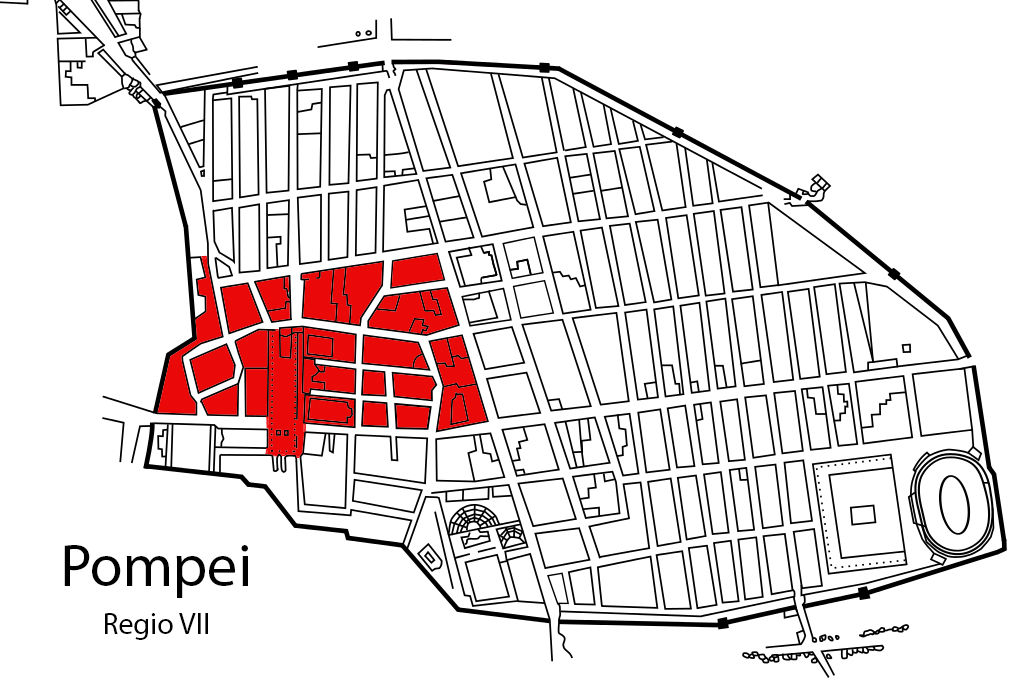 Figure 1. Pompeii, plan with the indication of Regio VII (in red).
 Figure 2. The localization of the Casa delle Nozze di Ercole in the insula VII, 9 (D’Alessio 2008, p. 277, Fig. 2).
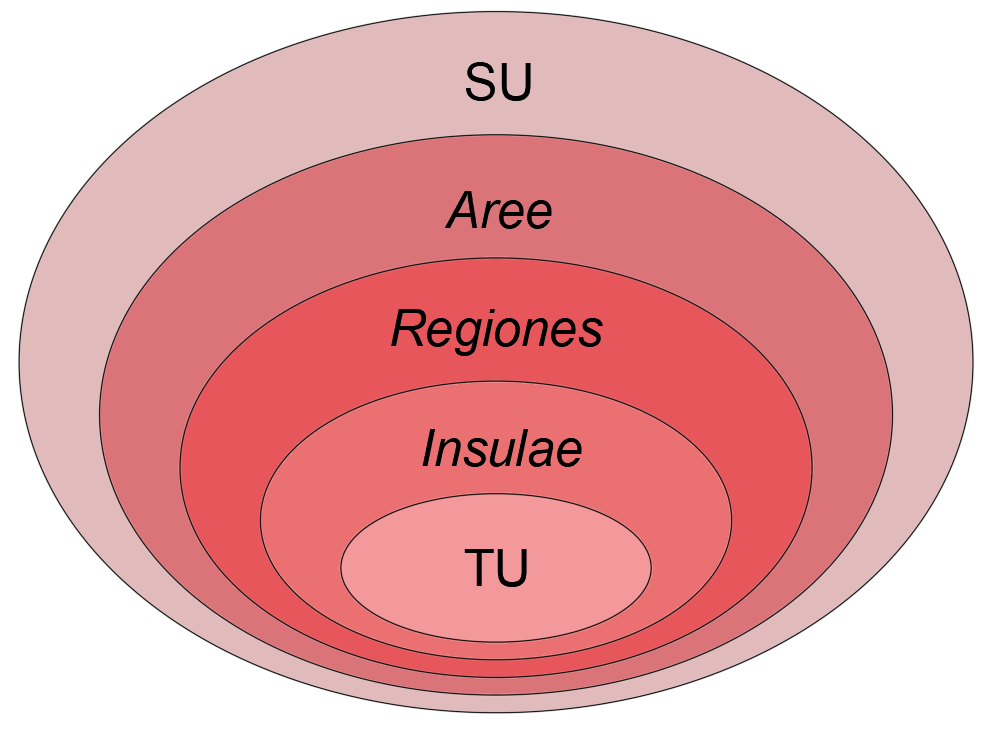 Figure 3. Archaeological information system: scheme of the logical structure.
 Figure 4. Pompeii, Regio VII: the new plan in progress.
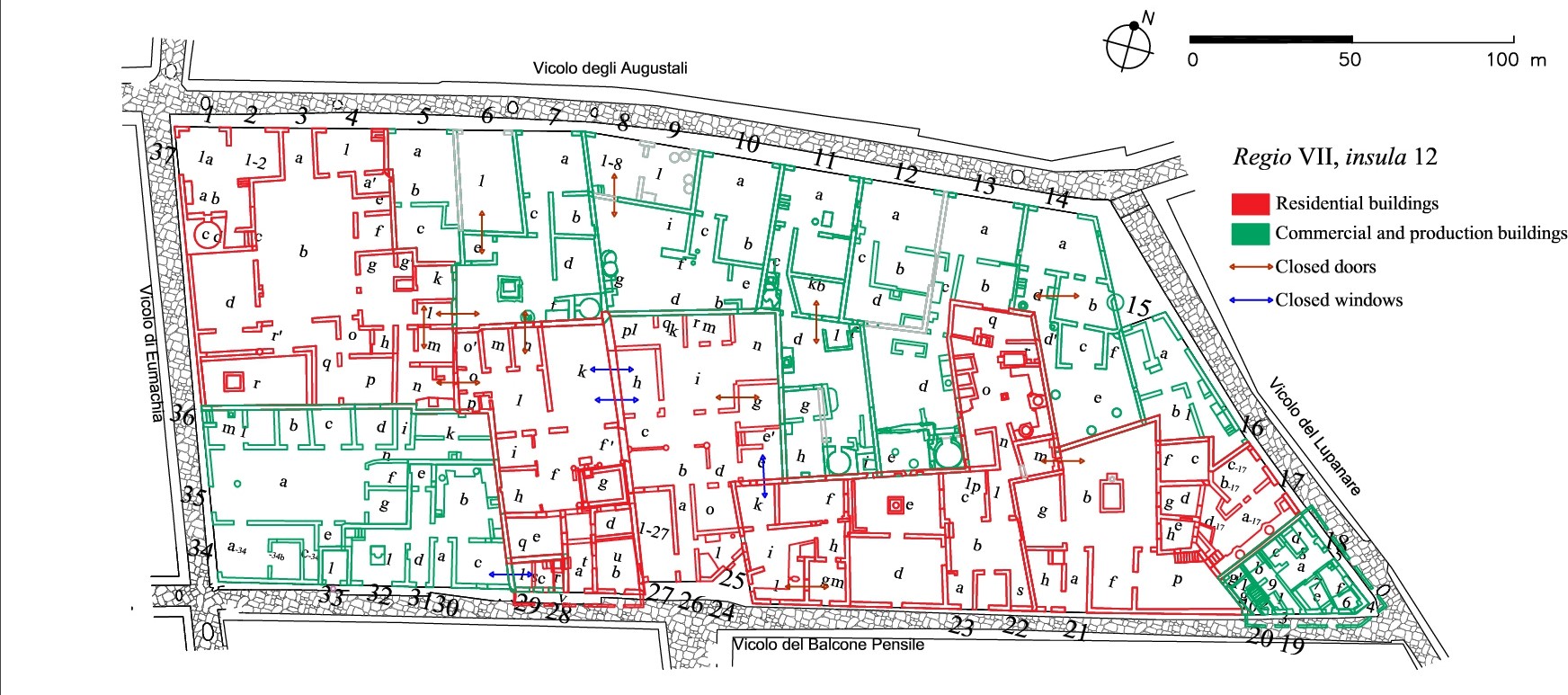 Figure 5. Pompeii, Regio VII, insula 12. Representation of the TUs documented in 79 C.E. with indication of the closed doors pertaining to the previous phases (Cartographic base: Morichi, Paone 2017).
 Figure 6. Pompeii, Regio VII, insula 12: the facade of the Casa del Balcone Pensile (VII, 12, 28). On the left, the buffered doors of number 29 (Photogrammetry by ‘Great Pompeii Project’. Topographic Referent: P VII 12 S3. Licensed by the Ministry of Culture - Archaeological Park of Pompeii: reprints or duplicates are forbidden).
 Figure 7. Pompeii, Regio VII, insula 4. In black the modern facilities; in purple the integration of architectures no longer visible (Cartographic base by ‘Great Pompeii Project’, licensed by the Ministry of Culture - Archaeological Park of Pompeii: reprints or duplicates are forbidden).
 Figure 8. Pompeii, Regio VII, insula 9: proposal of reconstruction of the Samnite buildings found below the Casa delle Nozze di Ercole (VII, 9, 47). In black the documented structures; in gray the logically reconstructable environments; in white the hypothetical integrations (D’Alessio 2008, p. 278, Fig. 8)
 Figure 9. On field work: Elena Pavanello in the viridarium of the Casa delle Quadrighe (VII, 2, 26).
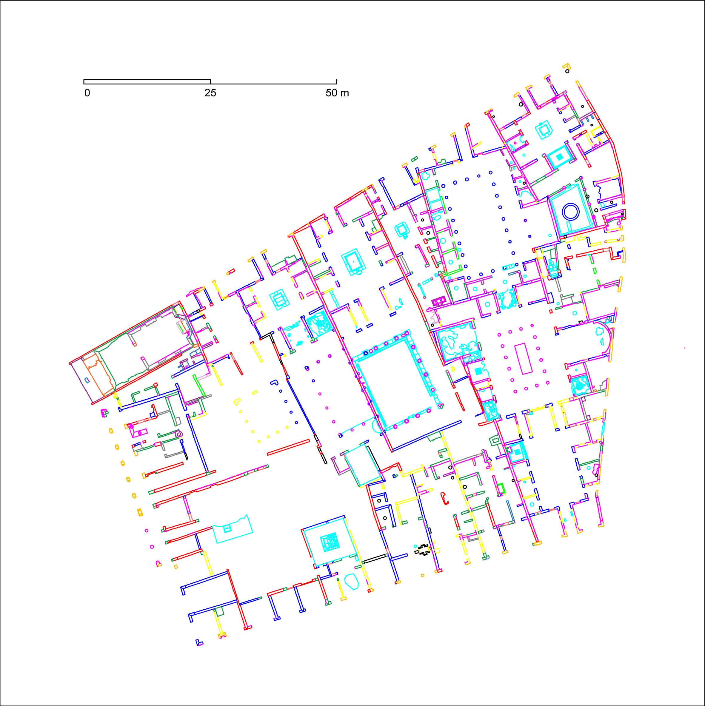 Figure 10: Pompeii, Regio VII, insula 4, plan: different colors refer to the identified relative chronology sequence (Cartographic base by ‘Great Pompeii Project’, licensed by the Ministry of Culture - Archaeological Park of Pompeii: reprints or duplicates are forbidden. Elaboration by V. Bruni).