A diachronic multi-source approach to the study of a historical landscape in Central-Western Europe: the Blies Survey Project
Blies Survey Project (BSP) is an international cross-border research project aimed at reconstructing the historical landscapes around the ancient settlement of Bliesbruck-Reinheim, within a radius of 12 km. The research project is focused on a region located between the eastern part of the Moselle department in France and the southern part of Saarland in Germany, between two river valleys (namely the Blies and the Sarre) characterized by a long-lasting human occupation, from prehistory to the present. The geomorphological context and the natural environment of the riverbanks and the low hills have been significantly interrelated with settlement patterns and human occupation.
Introduction
The Blies Survey Project (BSP) aims to study a region located in the eastern part of the Moselle in France and in the southern part of the Saarland in Germany (Hérapel, Schwarzenacker, Saarbrücken and Sarre Union), within a 12 km radius of the minor settlement of Bliesbruck-Reinheim, at roughly half the distance to other minor settlements (Figure 1) (Antonelli, Petit, Casolino 2022; Antonelli 2022).
This territory can be defined as the area of influence of the ancient settlement of Bliesbruck, where archaeological research has a long history, that has become systematic only since the early 1980s (Petit 2012, 425). It is located 75 km east of Metz and 15 km from Saarbrücken, in the valley of the river Blies, a tributary of the Saar, into which it flows at Sarreguemines.
Within the two current villages of Bliesbruck and Reinheim, the Blies valley is dominated to the north by the ‘Homerich’, a hill which rises 60 m above the valley and, due to its position and topography, has a particular importance in this micro-region. Thus, from the end of the Bronze Age to the early Middle Ages, settlements, sanctuaries, and necropolises developed in the valley at the foot of this elevation, whose main role is still today very partially defined.
Presently, this territory cut by the Franco-German border witnessed to an eventful history since the end of the 18th century and has now become a European centre for research and heritage development following the creation of the Archaeological Park supported by two local authorities, the Moselle Department, and the Saarpfalz-Kreis, with the support of the French Ministry of Culture and the Ministerium für Bildung und Kultur resp. Landesdenkmalamt of the Land Saarland.
The archaeological research carried out since 2004-2005 as part of an interdisciplinary programme (Petit, Reinhard 2009) has delimited the chronological framework of the Blies Survey Project, ranging from prehistory to the end of the Middle Ages, in a diachronic view of the Bliesbruck-Reinheim area, its territory and environment.
The space structured by the lower course of the Blies river represents a favourable area for studying the socio-environmental dynamics due to the natural characteristics and the human activity dating back at least to the Paleolithic (Bravard, Magny 2002).
The objective is to analyse the complex relationships between man and his environment, namely, on the one hand, the anthropic influence on this environment and, on the other hand, the adaptation of human settlements to environmental transformations. This analysis should make it possible to determine the relationships between human settlements and the environment during the different periods of occupation, within the framework of the development of a predictive approach for the detection of new archaeological sites. This objective requires the restitution of the characteristics of this natural space and its modifications in the long term, due to anthropisation. For this purpose, the characteristics of the environment of the settlements will be documented by means of mapping geographical, pedological and sedimentological data and by the enhancement of existing data. Special attention will be paid to changes in the relief, erosion phenomena and changes in the river system and valley bottoms (Flussaue). The relationship between human settlements and geo-ecological factors will be analysed and modelled using a Geographic Information System (GIS).
The overall objective is therefore to understand the settlement patterns of the area as an object of study over the long term and their transitions in relation to the Celtic princely centre of Reinheim and the Roman settlement of Bliesbruck.
This project aims to structure a European research network that will allow the sharing of methodologies, practices, and knowledge. This research, which has a strong propaedeutic connotation for the enhancement of cultural heritage in the region, is also linked to the improvement of cultural tourism, which is the driving force behind the region’s development.
Geology and geomorphology of the research area
The research area extends over a length of about 20 km on the lower course of the Blies and Saar rivers, as well as their tributaries. Seventy per cent of the watershed substrate of the Blies river is sandstone, hence the mainly sandy nature of its alluvium. The main tributary of the Blies, the Schwarzbach, on its left bank, flows completely over Voltzia sandstone (Upper Bundsandstein), which further increases the sand content of its alluvium. At Gersheim, 5 km upstream of the Bliesbruck-Reinheim site, the river meets the limestone layers of the Muschelkalk. These layers form the geological matrix of the Bliesbruck region (Figure 2).
On the German side, the Saar-Blies-Gau adjoins the Plateau Lorrain according to the terminology of H. Schneider (Schneider 1972, 7–10). In this morphostructural unit the large valleys are incised into the Lower, Middle and Upper Muschelkalk suite with gentle slopes and rounded hills.
On the French side, the Lorraine Plateau between the Saar and Bickenalb rivers is characterized by slightly less pronounced relief with numerous elevated plateaus and gentle slopes. The other aspects of the landscape up to the confluence of the Saar and Blies rivers are identical to those of the Saar-Blies-Gau. The upper Muschelkalk layers (Limestone with Ceratites above crinoidal Limestone) are characterized mainly by erosion-resistant and permeable limestones and dolomites, whereas the middle Muschelkalk layer (grey and variegated marls) is highly impermeable and forms a horizon where numerous springs appear, fed by water that has infiltrated through the upper Muschelkalk beds (Kubiniok, Brück 2012; 2016).
The range of hills that separates the two valleys reaches altitudes comprised between 360 and 400 meters. On the plateaus and flats or slightly sloping surfaces, the soils consist of loess and materials from the degradation of the upper Muschelkalk layers. Here brown calcareous soils marked by stagnant water predominate. In areas with steeper slopes, making the transition to the sides, brown, nutrient-rich rendzina soils appear locally. The sloping terrain below the Upper Muschelkalk plateau is marked by thin rendzina soils (Barth, Kubiniok 1998). Because of the good water supply, this land is well suitable for agriculture. The terraces of the Blies river are marked by sandy-silty deposits and colluvium dating mainly from the last Glacial Period. In some places, the brown soils that have formed are covered by more recent sediments (Brück and Kubiniok 2006, 6–8). The most important river in the region is the Saar, which lies to the west of the project area, while the main axis is the Blies valley. Coming from the Hunsrück, a part of the Rhine Schist Massif, the Blies river crosses the present-day border at Bliesbruck and then flows westwards to the Saar.
The centre of the Roman settlement of Bliesbruck is situated on an alluvial terrace. The limestone plateau moves slowly westwards underneath the marly Keuper and Lettenkhole beds; the whole of these sedimentary layers is laid on the Sarreguemines syncline whose NE-SW axis drives substantially the course of the Blies river towards its confluence with the Saar (Weisrock and Franoux 1993, 225).
Review of regional studies
Approaching the study of the region, it is clear how different chronologies have been subject to different depth of analysis.
The first excavation activities in the area around Bliesbruck, during which the uncovered wall ground plans were discovered from the years 1841 and 1879 on the Reinheim ‘Heidenhübel’. Subsequent old excavations include those from Bliesdalheim ‘Ober den Heizwiesen’ (1887-88), Wittersheim ‘Im Tattenbach’ (1899-1900) and Böckweiler (St. Stephan Church, 1941-42 and 1949-50) are worth mentioning (Stinsky 2018, 335-48).
However, a regional approach, with archaeological surveys, did not take place until the second half of the 20th century, under the authorization of the Service Régional d’Archéologie for the French part, and of the Landesdenkmalamt for the German part. Following the creation of local units of the Société d’Histoire et d’Archéologie de Lorraine, several prospections took place in different parts of the region. Especially, A. Schutz and A. Goret between 1950s and 1980s explored the area of the Pays de Bitche (Petry 1982; Goret 1982). In the meantime, funerary areas of Bronze and Iron age are excavated in the region (Kolling 1968; Mathiot 2018a), with the exceptional findings from the Reinheim Tomb of the Celtic Princess (Echt 1999); in comparison with the prehistoric and ancient periods, the metal ages are much less well documented by archaeological prospections. This difference can be explained in large part by the nature of the remains that can be recognized during a survey campaign and by the few excavations that have been carried out in the study-area.
In the late 1960s and 1980s, archaeological excavations were carried out at the villas of Grosswald and Heidenkopf (Flotté and Fuchs 2004, 721-27). The end of the eighties marks the beginning of the excavation in the Roman vicusof Bliesbruck (Schaub and Petit 1991; Petit 2000, 2003; Flotté and Fuchs 2004; Petit and Santoro 2016; Antonelli and Petit 2017) and in the nearby villa in Reinheim (Reinhard 2010; Sărăţeanu-Müller 2011; Stinsky 2016), which contributed to bring new attention to the theme of minor settlements (Petit, Mangin, and Brunella 1994). A summary of the archaeological research carried out in the micro-region of Bliesbruck-Reinheim is given by J.-P. Petit (2012).
Almost in the same years J. Kubiniok studied the region from a geoarchaeological point of view, thus creating an important dataset (Barth and Kubiniok 1998; 2004; Kubiniok and Brück 2012; 2016; Kubiniok 2013). An extensive review of the medieval sources is produced by R. W. L. Puhl (Puhl 1999).
At the beginning of the 21th century, new projects started in the area, approaching the landscape with new methods and tools. The Occupation de la frange orientale du territoire médiomatrique, led by P. Nusslein and E. Thomann investigated the area between the Alsace Bossue and partially the Pays de Bitche, following the research by J.-P. Petit on the placement of minor settlements in the area (Petit 1999; Thomann and Nüsslein 2001; Nüsslein and Petit 2010). At the same time, surface prospection was led by S. Schmit in the south-eastern sector of the research area and by H. Cappel around Blieskastel (Schmit, Asselin and Detrey 2021; Blouet, Cappel and Schmit 2019; Schmit, Schnitzler and Chalte 2017). The Bronze and Iron age landscape of the region is reviewed by W. Reinhard’s work and these studies are recently put in perspective by D. Mathiot (Reinhard 2003; Mathiot 2018b). In 2004 the Carte Archéologique de la Gaule – Moselleis published, reviewing all the archaeological evidence for the French area of the project (Flotté and Fuchs 2004). The studies of A. Stinsky (2015; 2018; 2019) on Roman rural settlement patterns build on previous works such as those of R. Göring (2000) and complete them with updated excavation and survey data. Large projects as Ruhrland have inquired the rural occupation from the late Iron Age to the end of the late antiquity, redefining the settlement pattern for the north-eastern Gaul, while a spatial quantitative approach to the Roman occupation of the area has been explored by A. Nüsslein (Reddé 2017; 2018; Nüsslein 2016a; 2016b; 2018; Nüsslein et al. 2017; Nüsslein, Bernigaud, and Reddé 2018).
However, the studies of E. Peytremann (2003, 2006, 2010) shed new light on the settlement pattern of the rural Middle Ages in northern France and also in the Moselle. For this area we also mention the study on rural settlements in the early Middle Ages carried out by J.-M. Blaising (2003).
Methodology
This research follows the footsteps of the major research on the landscape and population that has characterised this part of Europe over the last 25 years, opening up to a definition of the archaeological landscape that is not limited by a single chronology and is the result of a constant relationship between artefact and ecofact, between man and the environment (Favory et al. 1999; Favory and Van der Leeuw 1998; Saligny et al. 2012; Gandini, Favory, and Nuninger 2012; Keay et al. 2020; Campana 2018; Vermeulen et al. 2017; Keay et al. 2005).
The methodology of the project aims both at integrating existing archaeological legacy data and collecting new data from different sources. Giving the rich data sets available from previous research, it needed methodological tools to normalise previous finds, as well as to improve and refine existing data. The targets in the operation were to review and possibly precise the existing data for the study region but also to double check if the survey methodology worked as expected. In this framework, it developed different tools dedicated to the kind of data we needed to elaborate.
Database of sites
The first tool to be created was a geodatabase dedicated to the data from literature and archives. The definition of database fields required extensive thought in order to have a closed vocabulary that was functional for data systematisation and analysis. ‘Site’ was defined as a geographically defined item which may have one or more settlement and/or chronological descriptions.
Being interested in recording the variation in different settlement patterns and over different chronologies, a two-level definition schema was designed, with a more general level and a specific sublevel, (e.g., Level I=Rural settlement, Level II=villa or farm).
During the first 3 years of activity, a total of 1217 sites were recorded in the database so far (Figure 3).
All survey and bibliographic data were imported into a shared database with project partners and in a GIS platform.
The use of GIS is well established in the field of landscape archaeology (Conolly and Lake 2006; Chapman 2006; Campana 2018) although with its limits and critics, and it has been implemented elsewhere also for reviewing and testing legacy data (Verhagen 2018; Casarotto, Pelgrom, and Stek 2018).
Finally, applications of spatial analysis in similar regional studies have been implemented recently (Nüsslein 2018; Gillings, Hacigüzeller, and Lock 2020).
The GIS also integrated the geographical data of the project area, in particular the cross-border mapping of geomorphological, land use, geological, and hydrological data, which was carried out by the Department of Physical Geography and Environmental Studies of the University of Saarbrücken under the direction of Prof. J. Kubiniok.
Intensive Survey
The methodology adopted for the archaeological survey is an implementation of the one already applied in the Limagne survey project as part of the research on the development of the territories of the Arvernes and their neighbours in the Massif Central (Trément 2011, 51–96). The fields to be surveyed are divided into Prospection Units (UP), that can be defined as the smallest unit of information spatially identifiable on a plot of land at the time of the survey, whether it contains archaeological information or not. Each UP is described by reporting its GPS coordinates, all the spatial, geomorphological, and archaeological information as well as information on the conditions of visibility on the ground. In concrete terms, the UP is a homogeneous work area that serves as a framework for the fieldwork, the collection, recording and mapping of data.
In our case, the maximum survey unit was 50x50 m squares. The choice of this measure was determined by the dimensions of the fields and the number of prospectors present in the field (ca. 10). A line spacing of 10 m was used and along each line the collection is done on a 2 m wide strip, which is equivalent to 20% sampling. This type of spacing was chosen based on the following factors: type of field workings, variability of materials, identification of areas of spread and concentration of materials. Artefact collection methods are proposed by the different research groups (Moreauet al. 2011; Banning et al. 2017), and this could allow us to start thinking about the effectiveness and possible standardization of these collection systems.
If in a UP there is a concentration of artefacts, the prospectors stop and further define the limits of the concentration unit (UC), dividing in into smaller squares of 5 m/side. Inside a UC all artefact visible on its surface are collected (sampling 100%).
To evaluate areas of artefacts concentration more precisely during field prospection, a parameter was established based on the densities recorded on a sample of 100 UP prospected in sites already known from bibliography and archive data.
Finally, we established a threshold that corresponds to the average of the values obtained, and thus the parameter is the following: 3 sherds/sqm.
Therefore, the prospectors:
•make a first preliminary walk in which nothing is collected but which serves simply to record the presence/absence of artefacts (of any nature: tiles, ceramic, lithic etc.) as well as to take note of the quantity;
•thus, the prospector evaluates the quantity of artefacts per sqm, and if it is bigger than 3 fragments it is considered a ‘concentration’;
•it is then possible to proceed to the collection according to the method indicated above for the Units of Concentration.
Visibility index
To establish the visibility index, ranging from 5 (very low), to 4 (low), 3 (average), 2 (high), and 1 (very high) we considered the use of the soil, the type of agricultural activity, the presence of vegetation, the light conditions, the climate, etc. (Terrenato and Ammerman 1996; Amato et al. 2016; Casarotto et al. 2017). In fact, weather conditions also have an impact on visibility: cloudy and/or rainy weather is favourable for prospecting and dry and/or sunny weather is less favourable.
The ‘nuisance’ factors, such as vegetation conditions, climate, dryness of the soil, elapsed time of ploughing, etc., also influence the quantity of visible artefacts on the surface. The visibility index has been applied also for the calculation of density in UP and UC, as a correction coefficient: as shown below, lower visibility indexes may correct upward the artefact density.
The data of the UPs and UCs are recorded on a database that integrates the two forms for the Prospecting Unit (UP) and the Concentration Unit (UC).
The integration of data allows us to finally define the Unit of Occupation (UO), and eventually its nature and chronology.
Calculation of the density of artefacts in the UP and in the UC
In the processing of survey data, it was applied a statistical method.
For UP and UC, the density of artefacts (or quantity/area) is estimated using a formula that applies a correction coefficient (visibility index):
nFrg | nFrg =n. of potsherds in the UP or in the UC | |||
Density= | *K | where, | Sup=UP/UC surface area | |
Sup | ||||
K =visibility index |
The result is therefore weighted according to the conditions of the surveys. This formula was applied for ceramic artefacts and for the following chronologies:
•Pottery / Roman Age, Late Antiquity, Early Middle Ages, Middle Ages, Late Middle Ages, Early Modern.
•Tile or brick/ Roman Age
For certain categories of artefacts, notably prehistoric artefacts or slags, we simply took into account the number of remains (NR), without calculating density, given the different relevance of this artefacts in the sheer quantity of the archaeological deposit.
Artefact treatment
The artefacts were recorded in the database within each UP or UC sheet, according to the type of collection of the artefacts (out of concentration, in concentration). We have also noted the presence of a significant amount of material ‘out of chronology’, which can be considered as ‘background noise’ that comes from the amendment of the land and can thus indicate the areas of artefact dispersal.
The study of tiles included two analytical phases: one directly related to the field survey; the other to be performed in laboratory.
A morphological classification was performed on the finds, taking as model the work on tiles carried out in eastern Gaul (Clément 2013). Archaeometric analyses were carried out on the tile samples, in order to classify the various mixtures, using an optical microscope and a lens. At present, 18 fabric types have been identified (some of them with variants).
Although the work needs further study and a larger sampling, at present it is interesting to note the identification of two macro-types of fabric, respectively attributable to the Kalhausen-Weidesheim and Les Horres sites. This is significant if we consider the position of these two sites, each connected to different supply basins, production-commercial dynamics and road networks.
Aerial/Remote sensing
Aerial photography activities were implemented during the third year of activities, with the aim of prospecting sectors poor in other kind of data, and to check for the presence of traces of sites. Several evidence were identified in the south part of the Blies Survey Project area.
The aerial data came from two different datasets. The first image dataset was the French Geoportal (https://www.geoportail.gouv.fr/) which includes contemporary and historical aerial photography (1950-1965, 2000-2005, 2006-2010), and the possibility to overlap them with Cassini maps and the carte d’état-major (1820-1860). The second dataset came from drone aerial survey done during fieldwork campaigns.1
Remote sensing activities have allowed to survey approximately 325 hectares, identifying 11 new sites. Two sites already known from literature and classified as rural settlements, have been better defined as it was possible to read alignments traces that might indicate the spatial organisation of the settlements. In the study of the landscape, the 1m DEM (https: //geoservices.ign.fr/documentation/diffusion/telechargement-donnees-libres.html#rge-alti-1-m) by the IGN was a valuable tool to see small anomalies, paleochannels and similar features.
Geophysical surveys
The surface prospections are accompanied by geophysical measurements. These will be used to obtain further data on structure, type and size at specific sites. These measurements are carried out under the direction of Peter Haupt, Dominic Rieth of the University of Mainz and Andreas Stinsky. Depending on the site, three different measuring methods are used, sometimes in combination with each other: geomagnetics, geoelectrics and georadar.
For the geomagnetic measurements, a Ferex 4.032 fluxgate magnetometer with two probes was used.
The distance between the probes was 50 cm, four measurements were carried out per metre. The geoelectrical method using the RM 85 device; measurements were made with a distance of 50 cm between the electrodes. The georadar method using the IDS MT Hi Mod device, using a 200 to 600 Mhz frequency antenna. The profiles were measured at distances of 50 cm. The geophysical results complement the find measurements of superficially collected artefacts. Even without excavation, this provides initial indications of the use of the sites and provides important orientation for possible future excavation sections.
Non-invasive diagnostics have been implemented in the central area of the project (Bliesbruck’s vicusand the surroundings of the villa at Reinheim) since long time (Posselt 2006; Posselt, Pfnorr, 2007, 2008). In the BSP project, several areas have been investigated in the region, using GPR and electrical resistivity as well as geomagnetic methods (Figure 4). Eight areas have been investigated, bringing to light different kind of sites. The most important results come from the following sites: Reinheim BSP 176 (Haupt, Rieth and Stinsky 2019), Böckweiler BSP 970 e 971, 182, 368, 397 (Haupt, Rieth and Stinsky 2020), Breitfurt, Kirchheimer Hof, BSP 976 (Haupt, Rieth and Stinsky 2021), Ferme de Brandelfing, BSP 73 (Figure 5).
Occupation Unit (UO): definition and interpretation
The Occupation Unit (UO) is an area characterized either by a significant presence of artefacts of determined chronologies (e.g., prehistoric flints) or where one or more high density cluster of artefacts collide. It should be noted that for some periods the amount of material surfacing is influenced by the historical and cultural character of the way in which the buildings were built: for example, the absence of tiles and a reduced diffusion of ceramic material (compared to the Roman period) in the contexts of protohistory and the early Middle Ages makes the occupation less visible, and therefore in this case it will be necessary to apply a different scale of density values.
Normally, for the definition of the Occupation Unit we take into consideration the data collected in the field together with data coming from bibliography, archives, geophysics and geoarchaeology. The spatial definition of a UO is determined by the distribution of artefacts in the UCs and UPs, the positioning of aerial or underground anomalies, the morphology of the ground. In this framework UOs are a semi-interpreted concept, not yet defined by their supposed function but only by their spatial and quantitative attributes. The definition of ‘concentration’, ‘diffusion’ and ‘dispersion’ values in UOs is calculated by weighting the different degrees of density of the artefacts in the UPs and UCs.
Case application
Overlapping data: the case of Les Horres
Les Horres district was chosen with the intention of enhancing and refining the data already known from this site and it is solid evidence of the utility in the application of our multi-source methodology.
The district is located on the Lower Muschelkalk terrace on the north bank of the Blies, on a slight slope (5-8 degrees) facing south-east, at the locations ‘Auf dem Horres’ and ‘Unter dem Horres’.
The area is already known for a Celtic funerary area from the La Tène A/B period (BSP 620, Reinhard 2010, 250–61), a Celtic building from the La Tène D period and a large Roman settlement, probably a sanctuary (BSP site 526), that has been investigated by geophysics and excavated between 2005 and 2008 (Reinhard 2010). Some Neolithic artefacts, as a Type 310 arrowhead at site BSP 429 and a Type 320 arrowhead at site BSP 430were also found (Renard 2003). The settlement, probably a sanctuary (BSP 526), is located 1.5 km north-east of the minor centre of Bliesbruck. Its origin is an exceptional wooden building with a central plan dated to La Tène D130, polygonal in shape, consisting of a central space surrounded by a gallery and probably used for worship. It is characterized by a variety of Gallic coins which point out the relations with regions to the south-west and west (Wigg-Wolf 2010). All the studies underway tend to show that the Gallic polygonal building is of a cultic nature and that it is at the origin of a settlement from the Roman period, probably a vast sanctuary, abandoned during Late Antiquity. A thermal complex was also partially excavated. However, no temple has yet been found, although it is not impossible that a building consisting of a gallery with corner rooms identified by geophysical prospection corresponds to this type of building (Figure 6). A cremation grave of the Roman period (BSP 468) probably marks the eastern limit of the settlement.
It is a vast district, explored by preventive excavations, aerial surveys and geophysical surveys.
Geophysical surveys in 2006 revealed traces of structures on both sides of the Reinheim-Gersheim road (Reinhard 2010, 252–53).
Based on these previous investigations, Les Horres area was chosen with the intention of enhancing and refining the data already known from this site. The fields both north and south of the road, close to the previously surveyed and excavated areas, were surveyed.
Survey Raw Data
During 2018 and 2019 a total of 82 UP have been surveyed. Apart from one prehistoric Muschelkalk splinter, most of the artefacts belongs to the Roman, medieval and modern periods. Overall, the quantity of pottery from the Middle Ages and early modern period is small (73 fragments) and very scattered over the whole area surveyed, which may indicate areas where manure was spread or occasional use of the previous Roman site. Five slag finds are reported in four UPs in the western sector of the surveyed area, where small quantities of ceramics and tiles are noted, which do not allow us to identify it as a proper occupation (Figure 7).
The abnormal density of potsherds determined the detection of three Concentration Units: south of the road (relating to BSP 969), in the area of the excavated buildings, north of the road in the mid-slope area (relating to BSP 968). These Concentration Units are characterized by a strong concentration of tiles and Roman pottery, while only the latter presents also some late antiquity sherds.
Overlaying the data: Weidesheim district
The Weidesheim district is located in the Saar valley in the municipality of Kalhausen, on the right bank, 10 km from Bliesbruck-Reinheim; it is a complex district which extends over 1.5 km along the Saar, lined by the coal-mining canal on its left bank, including the hamlet of Weidesheim (attached to the municipality of Kalhausen in 1811) and its surroundings. It is located on the south-eastern part of the limestone plateau overlooking the Saar valley and the narrow valley of the Achen stream, which flows into this river to the west of the hamlet. The valley is marked by the presence of a limestone hillock which emerges from the sandy river terrace.
In the district of Weidesheim several archaeological remains have been found.
The village of Weidesheim has been known since the 14th century as the site of a fortified house or castle which was destroyed in 1380, rebuilt and then altered several times before being replaced by a modern building in the 1780s and 1790s. The late medieval fortified building still has a massive four-storey tower, to which a stair turret was added in the 16th century (Antonelli and Petit 2022).
The ‘état- major’ map of the 19th century shows the integration of Weidesheim into the network of roads before the major changes associated with the construction of the railway and the Kalhausen station, which led to protohistoric finds.
Other works affected the place: agricultural work, which led in particular to the discovery of the coloni Aperienses inscription (ILTG 3798), the digging of gravel pits along the departmental road to the Lower Rhine, the digging of trenches from July 1944 for the installation of defensive positions around the station (the route is visible on the aerial photograph of 1948), the digging of trenches in Weidesheim, the construction in 1967 or shortly before of a bypass around the hamlet and the construction of a gas pipeline which crosses the site (BSP 782 and BSP 783).
The aim of the investigation was to refine the location of previous finds, to determine their extent and to identify any new signs of occupation. The operation also focused on the chapel and its sculpted blocks in place, to make an inventory of all the elements and to obtain details on the missing part of the chapel. Moreover, the district was also investigated through aerial imagery, in order to locate cropmark anomalies; the analysis of the 1-m DEM by IGN was also taken into account.
The archaeological surveys in Kalhausen ‘Weidesheim’ confirmed a Mesolithic presence in the sector known from literature only for sporadic elements (Geyer, Petit, and Sainty 1979). The BSP surveys allowed us to define the area and characters of this Mesolithic occupation. In fact, 46 distinctive objects (flakes, blades, neo-crests, cores with semi-transformed debris) were collected, with debris almost exclusively of local middle Muschelkalk t4b limestone. Two fragments of a Neolithic polished flint axe were also collected.
New data on the protohistoric period were not found during the surveys, despite the funerary finds made during the construction of the station at the end of the 19th century. However, the area near the discovery site, between the railway line and the Departmental Road 33, has been completely disturbed by quarry diggings that have become shrubby wasteland. In addition, the sector opposite the station is built, which also prevents further investigations.
A Gallic coin was found during surface prospecting, but it probably relates to the nearby Roman settlement. This type of coin (SST 186) is still regularly found in early Roman contexts (Féliu 2012).
In Roman times, there were many different types of occupation, but the situation is very different between the hamlet of Weidesheim and the Saar valley between the Achen stream and the Eichel stream. Here, surface surveys have located Concentration Units that, for the most part may be interpreted as clusters of buildings separated by distances of 200m. In general, the survey data do not suggest that these were monumental buildings; this impression must be put into perspective by the fact that the land concerned has been continuously ploughed and probably deeply. However, all the sources agree in suggesting the absence of significant solid buildings: few stones, few or no architectural elements, no painted plaster or tiles linked to hypocausts. The collected artefacts indicate that these buildings were covered with tiles. The concentration of finds north of the locality of Benchenn seems to be the most important one since the altar of the coloni Aperienses was found there (BSP 782 and BSP 783). The indications given by Keune (1897) are precise enough to locate the site of the discovery of this inscription. The artefacts, mainly tile fragments, cover an area of 1200 sqm. Very few sherds were found, a few fragments of sandstone and a fragment of marble. Keune states that the block was found in an environment of building remains, but he does not report any evidence of special or quality furnishings.
The quantity and density of tiles suggests the existence of one or more buildings in the centre of locality of Bennchen. The nature of the occupation remains difficult to determine, however the presence of a significant number of slags and the small quantity of fine ceramics allows us to argue that it is linked to artisanal activities. A fragment of a large-diameter millstone found to the north-west of the concentration area, closer to the river, suggests the presence of a water mill (Picavet 2016, 695–712; Picavet et al. 2017).
The Concentration Units south of locality of Bennchen, is characterized by a large quantity of ceramics, including several fragments of fine ceramics, but also a significant quantity of slags. The quantity of ceramics at the site BSP 784 is very small, but the quantity of tiles is large and could therefore indicate the presence of a building. The area is characterized by the presence of slags.
The reading of aerial photographs from the French Geoportal made it possible to identify some traces in which two buildings are clearly visible, one rectangular and the other quadrangular, measuring approximately 380 sqm and 340 sqm respectively. These traces overlap precisely with the concentrations identified south of Bennchen (Figure 8).
The archaeological surveys carried out north of Bennchen, near the settlement of Weidesheim, revealed a concentration of materials. In particular, many tiles and several quantities of pottery were found. This concentration led to reflection on the relationship between this concentration and those at Bennchen and, therefore, on the extent of the settlement in Roman times.
The occupation is attested in late antiquity by a few sherds found during the surveys and by the discovery of 4th century coins.
Data about the Middle Ages are scarce. Remains of the Merovingian period were discovered north of the church (BSP 681), but their location is uncertain (Flotté and Fuchs 2004, 532). The archaeological survey conducted in this area confirmed this occupation through the discovery of several fragments of Merovingian pottery.
The date of construction of the chapel is also difficult to determine. It may have been already built in the Romanesque period, as the semi-circular arch with its straight feet made of Roman sculpted elements might suggest, but it could also be a discharge arch for the Gothic arch. This architectural question still needs to be addressed. According to the written sources, the chapel was rebuilt in the 15th century, which indicates the presence of an earlier building. Furthermore, the chapel is placed under the patronage of Saint Martin, which could also indicate an earlier creation.
The period up to the 14th century is completely unknown. Data from written sources indicate that in 1346 the land and a castle belonged to the lords of Weidesheim and were a fief of the Lordship of Bitche. The castle was destroyed in 1380, mentioned again in 1444 and transformed in the 15th and 16th centuries. A tower similar to the Turmburg type 26 still remains, with plasterwork from the 16th century (Jacops, Guillaume and Hemmert 1990, 65). The outbuildings of the present castle still have gunports dating from the 16th century.
Artefacts found in the river district have allowed the identification of material from the medieval period at concentrations in the centre and south of Bennchen. Similarly, in the area of the current settlement of Weidesheim on the concentration from the Roman period, where fragments from the Merovingian period were also found, a significant presence of medieval pottery was recorded (Figure 9).
Discussion
In the Les Horres district, the analysis of the collected data allowed us to identify six Units of Occupation (UO) for the Roman period and five for the medieval one (Figure 10).
In particular, for the Roman period in UO 2 the occupation is superimposed on a quadrangular structure (28 x 28 m) identified by geophysical prospection. In UO 10 the diffusion of the concentration of furniture corresponds to excavated structures: circular sacred building of La Tène D1 and main building. The dispersion in UO 10 is superimposed on a circular building (hypocaust) with three annex buildings. UO 23 corresponds to a building complex known from geophysical surveys. OU 31 and OU 32 are two occupations that may correspond to other buildings.
The sanctuary of Horres has only been explored on a small area, and the buildings identified by geophysical prospection remain to be defined more precisely. The methodical BSP surveys confirmed the presence of several occupation units around the sanctuary and also revealed new occupation areas (UO 11, UO 31, UO 32). The supposed buildings (UO 11 and 31) are located at a distance of about 160-190 m from the centre of the sanctuary (BSP 526).
The settlement appears to be quite large and is bounded to the east and west by the burial areas (BSP 522 and 421).
Finally, OU 27 is located to the NE, approximately 600 m from the central core and 400 m from OU 31. It is hypothesised that this is a rural settlement on the periphery of the main settlement, located at a distance of 600 m from yet another rural settlement located to the NE (BSP 465).
For the medieval period there are five Occupation Units (UO 41, 42, 43, 44 and 45). This could be areas where manure was spread or occasional occupation of the previous Roman site which may be linked, as in the case of the Bliesbruck agglomeration, to the recovery of materials within the more general framework of the exploitation of Roman sites (Clemens and Petit 1995).
The extensive collection of data from aerial and surface surveys increasingly shows the central role of the Kalhausen district (Figure 11). The BSP surveys made it possible to define more precisely the surface of the prehistoric occupation (UO 16). It confirms that this is probably a station camp from this period, probably of lesser importance in comparison with that of Reinheim ‘Allmend C’ on the banks of the Blies river (Donié, Erbelding, and Rick 2001), dated back to Early Mesolithic. The surveys also revealed some rare Neolithic artefacts.
For the Roman period, UO 17 is located in the area where an altar and traces that may correspond to a sanctuary were discovered in the past (BSP 782-783; these are presence of rubble and tiles identified by an ancient survey and a preventive investigation). The methodical survey BSP made it possible to define precisely the area of distribution of the material. The discovery of a marble fragment in UO 17 is reported.
In UO 18 the discovery of a fragment of a large Eifel basalt millstone is noteworthy.
The occupation units vary in size, with UO 18 and 19 being larger. Furthermore, UO 19 corresponds to the traces identified by aerial photographs in which two buildings are clearly visible, one rectangular and the other quadrangular of about 380 sqm and 340 sqm respectively.
The occupation units identified at Weidesheim Bennchen show a complex site, along the Saar, characterised by the presence of a sanctuary and several nuclei.
The organisation of the occupation units (distance and surface) is very similar to those identified at Reiheim Horres.
Finally, UO 28 is characterised by the presence of ceramics and tiles and appears to be oriented in a NE-SW direction. The concentration in UO 28 corresponds to the anomalies identified by the drone. UO 29 is approximately 160 m away from UO 28. If the interpretation of UO 28 as a rural settlement is accepted, UO 29 could correspond to a related building.
For the medieval period, there are two occupation units (UO 21 and 22) which are characterised by the scattering of material of the same typology: it is hypothesised that these are two different occupations which can be linked to the same site (village?). The total extension would amount to 5.130 ha.
There are traces of fortification (BSP 679) about 800 m to the north: the archives mention a hamlet and a castle in the 14th century, a fortified house in the 15th, 16th, 17th and 18th centuries and at 900 m the chapel of Weidesheim (BSP 680) is noted.
The late medieval settlement of Weidesheim, Bennchen (UO 21, 22) could be related to the chapel and the Weidesheim estate and could be one of the villages in the Weidesheim territory.
To the north of Bennchen, the late medieval occupation of Weidesheim (UO 33), could be related to the chapel and the castle attested as early as the 14th century. The ceramics collected during methodical BSP walking surveys confirm the 14th century date. Thus, the occupation to the north of Bennchen would constitute the north-western limit of the settlement linked to the medieval fortification (at least from the 14th century) and the chapel. The settlement with the fortification and the chapel would have an extension of about 5.100 ha.
The date of the construction of the chapel is difficult to determine, as it already existed in the Romanesque period, but the actual construction date is unknown. Its foundation in the Carolingian period has not yet been confirmed. It remains only a hypothesis based on the location of the church in relation to an ancient settlement and on the reuse of carved blocks and Roman architectural elements.
One issue that came out unambiguously from our evaluation is that certain chronologies tend to appear less (or not at all) from surface prospection (for example for the Bronze, Early Iron Age and early and high Middle Ages).
At this point we can present some preliminary consideration in the evaluation of the methodology of our project.
In dealing with the amount of data already collected from previous research, a few issues emerged that are worth exploring. The existing data are a mine to be exploited: the possibility of collecting and systematising existing data, that have been investigated with different techniques and methodologies on both sides of the Franco-German border, has highlighted how data themselves are known as crystallised in time and space but they reserve the possibility of being deepened and refined if investigated through capillary research methodologies and with a diachronic and multi-source approach. A major limitation of previous spatial studies is that they are embedded in research projects that are strongly chrono-typologically framed. They have therefore failed to consider the fact that the landscape is a palimpsest of anthropic and natural actions which require a temporal dimension in order to be fully understood, in their antecedents and consequences.
At the same time the specific survey and artefact collection methodology was effective in identifying and delimiting underground structures and buildings, as it is clearly shown by the overlapping of some UOs with the geophysical anomalies. Thus, our survey tool allowed us to tackle one of the issues related to previous data, or the low spatial and typological definition of data themselves. By utilizing aerial, surface and geophysical surveys on previously known sites we have been able so far to refine and enhance our data resolution. It is the case of Kalhausen – Weidesheim district, where we have been able to precisely locate the sites along the riverbank as well as to add new spatial and quantitative data on the prehistoric occupation; unsurprisingly, also data from much later chronologies came out, helping us to understand the long-term pattern of the occupation of the district.
One issue that came out unambiguously from our evaluation is that certain chronologies tend to appear less (or not at all) from surface prospection. It is the case for example for the Bronze and Early Iron Age artefacts, whose presence is close to zero from surface prospection, while general evidence in the region suggests that Bronze and Iron Age sites were fairly common and distributed. This absence is due to several factors. The materiality of Bronze and Iron Age differs greatly in terms of quantity and durability. Most of the recorded sites for those periods are funerary areas and more specifically mounds and urn fields, found by excavations. Residential settlements are almost unknown in the area, apart for the Bronze Age village near the Roman villa of Bliesbruck; probably also the fact that those settlements were supposedly built almost exclusively by wood makes them hard to find by means of surface surveys. To overcome the issue, we will experiment with different kinds of remote sensing (especially with LiDAR) that may help us to find hillforts and other kind of settlements.
A similar problem emerged also for the early and high Middle Ages. For these periods our surveys recorded few ceramic materials; moreover, medieval settlements were characterized by constructions made of perishable materials, which are quite invisible in surveys. If we were to compare the sheer quantity of potsherds from other periods (i.e. Roman pottery) we would be led to argue that medieval settlements were at least few and reduced in size. By crossing prospection data with other sources (such as archive and literary sources), the (scarce) quantity of material can be put in a correct historical and archaeological perspective.
The last issue is related to the nature of the bibliographic and archaeological data in terms of their distribution. If we look at BSP’s research area, we notice how some areas seem to present less evidence than others; this is especially true for the southwest quarter of the research area. The reasons for that are not related to the settlement patterns of the area: the area west to the course of the Saar is covered by woods to a greater extent than other areas and is, in its northern district, more urbanised, thus affecting the visibility of the archaeological evidence.
Conclusions
BSP project aimed at the reconstruction of the historical landscapes of the Blies river district. In our investigation, the development of an integrated multi-source approach was crucial to review refine and update previous bibliographic data in the region; this, in turn, produced an enhanced image of the settlement pattern and the historical processes that affected the area. Both field and bibliographic data elaborated through a quantitative approach allowed a spatial definition and a chronological transformation of the sites. Specifically, the definition of Prospection and Concentration Unit and the analysis of artefacts in relation to their chronology, have made it possible to link the quantitative data to the spatial definition, leading to the definition of precise occupation areas depending on the individual chronologies. This allowed to theorise the Occupation Unit in which the component of space and time allow to reconstruct the development of a site in its becoming. This is especially clear for Les Horres and Kalhausen districts, where the application of such methodology led to an increase the data resolution. In this first phase of the work this methodology gave excellent results in terms of the precise definition of sites plan and chronology. Starting from this, the second phase of the project will aim to analyse the relationships between the sites for a definition of their function and to reconstruct the settlement systems.
Acknowledgement
The project is supported on the French side by the Département de la Moselle with the permission and financial support of the Ministry of Culture, on the German side by the Saarpfalz-Kreis with the support of the Ministerium für Bildung und Kultur resp. Landesdenkmalamt of the Land Saarland, and on the Italian side by the University of Chieti with the financial support of the Italian Ministry of Foreign Affairs-MAECI.
References
- Amato, V., M. Cozzolino, G. De Benedittis, G. Di Paola, V. Gentile, C. Giordano, P. Marino, C. M. Rosskpof, and E. Valente. 2016. ‘An integrated quantitative approach to assess the archaeological heritage in highly anthropized areas: the case study of Aesernia (southern Italy).’ Acta IMEKO5, 2: 33-43.
- Antonelli, S. 2022. ‘Archeologia e comunità in un’area transfrontaliera. Alcune riflessioni sul Blies Survey Project.’ IX Congresso Nazionale di Archeologia Medievale (Alghero, 28 settembre-02 ottobre 2022), edited by M. Milanese, 13-17. Firenze: All’Insegna del Giglio.
- Antonelli, S. and J.-P. Petit. 2022. ‘Nouvelles recherches archéologiques à Weidesheim (Kalhausen, département Moselle).’ Les Cahiers Lorrains, 2022, 1: 10.
- Antonelli, S., J.-P. Petit, and C. Casolino. 2022. Blies Survey Project. Recherches pluridisciplinaires sur l’occupation du territoire autour de Bliesbruck-Reinheim, de la Préhistoire au Moyen Âge, Rapport de synthèse PCR, Bliesbruck-Metz.
- Antonelli, S., and J-P. Petit. 2017. ‘L’agglomération de Bliesbruck (Moselle) durant l’antiquité tardive : entre ruptures et continuités.’ Gallia74, 1: 149–64. DOI: https://dx.doi.org/10.4000/gallia.2428.
- Banning, E. B., A. L. Hawkins, S. T. Stewart, P. Hitchings, and S. Edwards. 2017. ‘Quality Assurance in Archaeological Survey.’ Journal of Archaeological Method and Theory24, 2: 466–88. DOI: https://10.1007/s10816-016-9274-2.
- Barth, B., and J. Kubiniok. 1998. ‘Soil Degradation and GIS-Based Soil Erosion Prediction in South-Western-Germany (Saarland).’ In Proceedings of the 16th World Congress of Soil Science, 1-7. Montpellier: International Soil Science Society.
- Barth, J., and J. Kubiniok. 2004. Bodenerosion in landwirtschaftlich genutzten Gebieten des Saarlandes. Chronologie, Ausmaß und GIS-gestützte Prognose. In Zukünftige Anforderungen an Forschung und Untersuchung für Landwirtschaft, Umwelt und Verbraucher, Kongressband 2003 Saarbrücken (VDLUFA-Schriftenreihe 59), 693-704. Bonn: VDLUFA-verlag.
- Blaising J.-M. 2003. ‘L’habitat du haut Moyen Âge en vallée de la Moselle : situation par rapport aux sites antiques et au bas Moyen Âge.› In Burgondes, Alamans, Francs et Romains dans l’Est de la France, le Sud-Ouest de l’Allemagne et la Suisse, Ve -VII e siècle après J.-C., Actes des XXe Journées internationales d’archéologie mérovingienne (Besançon, 20-22 octobre 2000), edited by F. Passard, S. Gizard, J.-P. Urlacher and A. Richard, 87-298. Besançon: PUFC.
- Blouet, V., H. Cappel, and S. Schmit. 2019. ‘Découverte d’une carrière de meules protohistorique et historique à Holz (Allemagne, Sarre).’ Les Cahiers Lorrains1-2: 75-81.
- Bravard J.-P. and M. Magny. Eds. 2002. Les fleuves ont une histoire: paléo-environnement des rivières et des lacs français depuis 15 000 ans. Paris: Éditions Errance.
- Brück, D., and J. Kubiniok. 2006. Bericht Zu den Pedologischen und geomorphologischen Geländearbeitenbei Bliesbruck 2006. Saarbrüken: Physische Geographie und Umweltforschung Universität des Saarlandes.
- Campana, S.R.L. 2018. Mapping the Archaeological Continuum. Filling ‘Empty’ Mediterranean Landscapes.SpringerBriefs in Archaeology. Cham: Springer International Publishing.
- Casarotto, A., T. D. Stek, J. Pelgrom, R. H. van Otterloo, and J. Sevink. 2017. ‘Assessing visibility and geomorphological biases in regional field surveys: The case of Roman Aesernia.’ Geoarchaeology33(1). doi: 10.1002/gea.21627
- Casarotto, A., J. Pelgrom, and T. D. Stek. 2018. ‘Surface Visibility and Legacy Survey Data: Between Desktop-Based Analysis and New Fieldwork.’ In Spatial Patterns in Landscape Archaeology: A GIS Procedure to Study Settlement Organization in Early Roman Colonial Territories., edited by A. Casarotto, 91–103. Leiden: Leiden University Press.
- Chapman, H. 2006. Landscape Archaeology and GIS. London: The History Press Ltd.
- Clemens, L., and J.-P. Petit. 1995. ‘Un habitat de la fin du Moyen Age dans les thermes de Bliesbruck.’ Archéologie Médiévale25: 65–85.
- Clément, B. 2013. Les couvertures de tuiles en terre cuite en Gaule du Centre-Est(II s.av.-III s.ap. J.-C.). Monographies instrumentum 46. Montagnac: Éditions Monique Mergoil.
- Conolly, J., and M. Lake. 2006. Geographical Information Systems in Archaeology. Cambridge Manuals in Archaeology. Cambridge, New York: Cambridge University Press.
- Donié, S., S. Erbelding, and S. Rick. 2001. ‘Der frühmesolitische Siedlungsplatz Reinheim, Gemeinde Gersheim, Saarland. Vorbericht der Grabungen von 1997 bis 1999 im Allmend C.‘ Bulletin de la Société Préhistorique Luxembourgeoise, 20–21, 1998–1999: 247-99.
- Echt, R., ed. 1999. Das Fürstinnengrab von Reinheim.Studien zur Kulturgeschichte der Früh-La Tène – Zeit, Bliesbruck-Reinheim. Blesa 2. Bliesbruck-Reinheim: Parc archéologique européen.
- Favory, F., J. J. Girardot, L. Nuninger, and F. P. Tourneux. 1999. ‘ARCHAEOMEDES II: Une Étude de La Dynamique de l’habitat Rural En France Méridionale, Dans La Longue Durée (800 Av. J.-C.-1600 Ap. J.-C.).’ AGER9: 15–35.
- Favory, F., and S. Van Der Leeuw. 1998. ‘Archaeomedes, la dynamique spatio-temporelle de l’habitat antique dans la vallée du Rhône: bilan et perspectives.’ Revue archéologique de Narbonnaise31 (1): 257–98. DOI: https://dx.doi.org/10.3406/ran.1998.1509.
- Féliu, C. 2012. ‘Monnaies et frontières dans la vallée du Rhin supérieur à La Tène finale.’ In L’Âge du Fer entre la Champagne et la vallée du Rhin, 34e colloque international de l’Association Française pour l’Étude de l’âge du Fer (Aschaffenburg, 13-16 mai 2010), edited by M. Schönfelder and S. Sievers, 459-67. Mainz: Schnell & Steiner.
- Flotté, P., and M. Fuchs, eds. 2004. La Moselle. Carte archéologique de la Gaule, 57/1. Paris: Ed. Académie des Inscriptions et Belles-Lettres.
- Gandini, C., F. Favory, and L. Nuninger. 2012. Seven Millenia of Territorial Dynamics: Settlement Pattern, Production and Trades from Neolithic to Middle Ages. Oxford: British Archaeological Reports. https://hal.univ-brest.fr/hal-01164869.
- Geyer, B., J.-P. Petit, and J. Sainty. 1979. ‘Une station mésolithique à Kalhausen.’ Cahiers Sarregueminois12: 741–44.
- Gillings, M., P. Hacigüzeller, and G. R. Lock, eds. 2020. Archaeological Spatial Analysis: A Methodological Guide. New York: Routledge.
- Goret, A. 1982. ‘Tableaux récapitulatifs.’ Les Pays de Bitche, 10: 7–10.
- Göring, R. 2000. ‘L’environnement Rural de l’agglomération Secondaire de Bliesbruck à l’époque Gallo-Romaine.’ Les Cahiers Lorrains 3: 295-322.
- Haupt, P., D. Rieth, and A. Stinsky. 2019. ‚Prospektionen zwischen zwei bedeutenden Siedlungsplätzen bei Gersheim-Reinheim.‘ Denkmalpflege im Saarland. Jahresbericht 2018: 48-50.
- Haupt, P., D. Rieth, and A. Stinsky. 2020. ‚Landschaftsarchäologische Untersuchungen an einer römischen Siedlungskette bei Böckweiler.‘ Denkmalpflege im Saarland. Jahresbericht 2019: 67-71.
- Haupt, P., D. Rieth, and A. Stinsky. 2021. ‚Verschwundene Kirche wiederentdeckt‘. Archäologie in Deutschland3: 61.
- Jacops, M.-F., J. Guillaume and D. Hemmert. 1990. Le pays de Bitche, Moselle. Images du patrimoine 80. Metz: Editions Serpenoise.
- Keay, S., M. Millett, L. Paroli, and K. Strutt. 2005. Portus: An Archaeological Survey of the Port of Imperial Rome. Rome: British School at Rome.
- Keay, S., M. Millett, K. Strutt, and P. Germoni, eds. 2020. The Isola Sacra Survey: Ostia, Portus and the Port System of Imperial Rome. Cambridge: McDonald Institute for Archaeological Research.
- Keune, W. 1897. ‚Trouvailles archéologiques.‘ Jahrbuch der Gesellschaft für lothringische Geschichte und Altertumskunde: 334-37.
- Kolling, A. 1968. Späte Bronzezeit an Saar und Mosel. Saabrücken 1968.
- Kubiniok, J. 2013. ‘D’un paysage naturel à un paysage façonné par l’homme. La région de la Blies inférieure (‘ pays ‘ de La Blies) et l’aire de peuplement de Bliesbruck-Reinheim’. Dossier d’Archeologie24: 108–13.
- Kubiniok, J., and D. Brück. 2012. ‚Umweltarchäologische Untersuchungen zur Siedlungs- und Landschaftsentwicklung der Siedlungskammer Bliesbruck/Reinheim.‘ In: Historsiche Blicke auf das Land an der Saar, 60 Jahre Kommission für Saarländische, Landesgeschichte und Volksforschung (Veröffentlichungen der Kommission für Saarländische Landesgeschichte und Volksforschung, 45), edited by B. Kasten, 39-51. Saarbrücken : Kommission für Saarländische Landesgeschichte und Volksforschung e. V.
- Kubiniok, J., and D. Brück. 2016. ‚Holozäne-Relief und Landschaftsentwicklung der Siedlungskammer Bliesbruck-Reinheim.‘ In Monumente der Macht. Die gallo-römischen Grossvillen vom längsaxialentyp, edited by Echt R., Birkenhagen B., and Sarateanu-Müller F, 379–95. Bonn: Dr. Rudolf Habelt GmbH.
- Mathiot, D. 2018a. ‚Découverte d’une nécropole du Bronze final à Bliesbruck ‚ Obere Betschwiese.‘ In Blesa 8, edited by J.-P. Petit, 13–22. Bliesbruck-Reinheim: Parc Archéologique Bliesbruck-Reinheim.
- Mathiot, D. 2018b. ‘Les dynamiques d’occupation du sol dans la vallée de la Blies du Bronze final à la fin de l’âge du Fer : bilan et perspectives à partir des données domestiques et des découvertes récentes.’ In Blesa 8, edited by J.-P. Petit, 23-52. Bliesbruck-Reinheim: Parc Archéologique Bliesbruck-Reinheim.
- Moreau, A., S. Morice, S. Salvador-Blanes, and H. Bourennane. 2011. ‘Distribution spatiale des objets archéologiques et mouvements de matière à l’échelle des versants cultivés : le cas de Mougon (Indre-et-Loire, France).’ ArchéoSciences, no. 35 (April): 103–16. DOI:https://dx.doi.org/10.4000/archeosciences.2987.
- Nüsslein, A. 2016a. ‘Des ateliers monétaires dans les campagnes médiomatriques pendant l’Antiquité tardive : qui sont les fabricants de monnaies d’imitation de la vallée de la Sarre ?’, in Monnaies et monétarisation dans les campagnes de la Gaule du Nord et de l’Est, de l’âge du Fer àl’Antiquité tardive, edited by S. Martin, 141–57. Bordeaux: Ausonius Éditions.
- Nüsslein, A. 2016b. ‘Nuancer et améliorer l’analyse des systèmes de peuplement basée sur les données de prospections pédestres. L’étude de la dynamique d’occupation antique du plateau Lorrain.’ Archeologia e Calcolatori27: 47–64.
- Nüsslein, A. 2018. Les campagnes entre Moselle et Rhin dans l’Antiquité. Dynamiques du peuplement du Ier s. av. J.-C. au Ve s. apr. J.-C. Strasbourg: Association pour la Valorisation de l’Archéologie du Grand Est.
- Nüsslein, A., N. Bernigaud, K. Boulanger, G. Brkojewitsch, G. Daoulas, Georges-Leroy M., Meyer N. and S. Ritz 2017. ‚La Lorraine.’ In Gallia rustica 1. Les campagnes du nord-est de la Gaule, de la fin de l’âge du Fer àl’Antiquité tardive,edited by M. Reddé, 555–656. Bordeaux: Ausonius Editions.
- Nüsslein, A., N. Bernigaud, and M. Reddé. 2018. ‘Les établissements ruraux du Haut-Empire.’ In Gallia rustica II. Les campagnes du Nord-est de la Gaule, de la fin de l’Âge du fer àl’Antiquité tardive, edited by M. Reddé, 133–233. Bordeaux: Ausonius Editions.
- Nüsslein, P., and J.-P. Petit 2010. ‘La vallée de la Sarre et de la Blies dans l’Antiquité. De Sarre-Union à Schwarzenacker et Sarrebruck, en passant par Bliesbruck-Reinheim.’ Les Cahiers Lorrains1/2: 6–21.
- Petit, J.-P., M. Mangin, and P. Brunella, eds. 1994. Les agglomérations secondaires: la Gaule Belgique, les Germanies et l’Occident romain. Actes du Colloque de Bliesbruck-Reinheim, Bitche (Moselle), 21,22, 23 et 24 octobre 1992. Paris: Edition Errance.
- Petit, J.-P. 1999. Le quartier Est de l’agglomération secondaire de Bliesbruck (Moselle). D.F.S. de fouilles programmées, 1989-1992, Service d’archéologie du département de la Moselle.
- Petit, J.-P., ed. 2000. Le complexe des thermes de Bliesbruck (Moselle). Un quartier public au coeur d’une agglomération secondaire de la Gaule Belgique. Blesa 3. Paris: Exé productions, éditions Serpenoise.
- Petit, J.-P. 2003. Le quartier artisanal Ouest de l’agglomération secondaire de Bliesbruck (Moselle). Fouilles de 1978 à 1987. DFS de fouilles programmées.
- Petit, J.-P. 2012. ‘La Micro-Région de Bliesbruck-Reinheim (Dép. Moselle / F; Saarland / D) à l’époque romaine. État des recherches.‘ In : Römische Landnutzung in Der Eifel. Neue Neue Ausgrabungen und Forschungen. Tagung in Mayen, vom 3. bis zum 6. November 2011. Römisch-Germanisches Zentralmuseum, edited by M. Grunewald and S. Wenzel, 387-430. Mainz: Verlag des RGZM.
- Petit J.-P., and W. Reinhard. 2009. Bliesbruck-Reinheim Recherches Sur Un Site archéologique Transfrontalier. Projet Collectif de Recherche 2007-2009. Bliesbruck.
- Petit, J-P., and S. Santoro. 2016. ‘Le centre public d’une agglomération secondaire de la cité des Médiomatriques : Bliesbruck (Moselle).’ Gallia73.2: 213-83. https://doi.org/10.4000/gallia.276
- Petry, F. 1982. ‘Données nouvelles sur les cultes gallo-romaines du Pays de Bitche.’ Le pays de Bitche àl’époque gallo-romaine10: 54–67.
- Peytremann, É. 2003. Archéologie de l’habitat rural dans le nord de la France du IVeau XIIe siècle, Saint-Germain-en-Laye. Saint-Germain-en-Laye: Association française d’archéologie mérovingienne. Mémoires.
- Peytremann, É. 2006. ‘L`habitat déserté de Gungling á Grosbliederstroff (Moselle) (IXe-XVe siècle).’ Archéologie Médiévale36: 57–114.
- Peytremann, É. 2010. ‘L’archéologie de l’habitat rural du Haut Moyen Âge dans le nord de la France: Trente ans d’apprentissage.’ In Jean Chapelot. Trente ans d’archeologie medievale en France. Un bilan pour un avenir. 9e Congrès international de la Société d’Archéologie Médiévale, 105–17. Paris:CRAHAM.
- Picavet, P. 2016. ‘De grandes meules gallo-romaines en grès découvertes dans le nord de la France et en Belgique. Aspects typologiques et techniques.’ In Archéologie des moulins hydrauliques, àtraction animale et àvent, des origines àl’époque médiévale et moderne en Europe et dans le monde méditerranéen, Actes du colloque international, (Lons-le-Saunier du 2 au 5 novembre 2011, edited by L. Jaccottey and G. Rollier, 695–712. Besançon: Presses Universitaires de Franche-Comté.
- Picavet, P., G. Fronteau, V. Le Quellec, and F. Boyer. 2017. ‘Les productions de meules en grès dévonien dit ‘ Arkose ‹ d’Haybes / Macquenoise de la fin de l’Age du Fer à l’Antiquité tardive dans le Nord de la Gaule : caractérisation typologique, chronologie et diffusion.’ In Les meules du Néolithique àl’époque médiévale : technique, culture, diffusion, Actes du 2ème colloque du Groupe Meule (Reims, du 15 au 17 mai 2014), 43ème supplément à la Revue Archéologique de l’Est, edited by O. Buchsenschutz, S. Lepareux-Couturier, and G. Fronteau, 267–81. Dijon: Université de Bourgogne.
- Posselt, M. 2006. Geophysikalische Prospecktion auf dem nördliche Gräberfeld des römischen vicus von Bliesbruck. Rapport. Mühltal.
- Posselt, M., and S. Pfnorr. 2007. Geophysikalische Prospektion auf dem Arela des des römischen Vicus von Bliesbruck, Département Moselle, Frankreich. Rapport. Mühltal.
- Posselt, M., and S. Pfnorr. 2008. Geophysikalische Prospektion auf dem Arela des des römischen Vicus von Bliesbruck, Département Moselle, Frankreich. Rapport. Mühltal.
- Puhl, R. W. L. 1999. Die Gaue und Grafschaften des frühen Mittelalters im Saar-Mosel-Raum: philologisch-onomastische Studien zur frühmittelalterlichen Raumorganisation anhand der Raumnamen und der mit ihnen spezifizierten Ortsnamen. Beiträge zur Sprache im Saar-Mosel-Raum, Bd. 13. Saarbrücken: SDV, Saarbrücker Druckerei und Verl.
- Reddé, M. 2017. Gallia rustica I. Les campagnes du nord-est de la Gaule, de la fin de l’âge du Fer à l’Antiquité tardive. Bordeaux: Ausonius Editions.
- Reddé, M. 2018. Gallia rustica II. Les campagnes du Nord-est de la Gaule, de la fin de l’Âge du fer à l’Antiquité tardive. Bordeaux: Ausonius Editions.
- Reinhard, W. 2003. ‚Studien zur Hallstatt- und Frühlatènezeit im südöstlichen Saarland.‘ In Blesa4: Gersheim: Stiftung Europäischer Kulturpark Bliesbruck-Reinheim.
- Reinhard, W. 2010. ‚Kelten, Römer Und Germanen Im Bliesgau.‘ In Denkmalpflege Im Saarland 3. Gersheim: Stiftung Europäischer Kulturpark Bliesbruck-Reinheim.
- Renard, C. M. 2003. ‘Les armatures de flèche de la fin du IVe et du IIIe millénaire dans le Bassin parisien.’ DEA Dissertation, Université Paris 1 Panthéon – Sorbonne.
- Saligny, L., L. Nuninger, K. Ostir, N. Poirier, E. Fovet, C. Gandini, E. Gauthier, Z.Kokalj, and F. Tolle 2012. ‘Models and tools for territorial dynamic studies. Spatial dynamics of settlement patterns and natural resources: towards an integrated analysis over a long term, from Prehistory to the Middle Ages.’ In Seven Millenia of Territorial Dynamics: Settlement Pattern, Production and Trades from Neolithic to Middle Ages, edited by Gandini, C., F. Favory, and L. Nuninger, 25-44. Oxford: British Archaeological Reports.
- Sărăţeanu-Müller, F. 2011. ‘The Roman Villa Complex of Reinheim, Germany.’ In Villa Landscape in the Roman North. Economy, Culture and Lifestyles, edited by N. Roymans and T. Derks, 301–16. Amsterdam: Amsterdam University Press.
- Schaub, J., and J.-P. Petit. 1991. Fouille programmée de Bliesbruck, rapport de synthèse 1989-1991. Bliesbruck.
- Schneider, H. 1972. Die naturräumlichen Einheit, Blatt 159 Saarbrücken, Naturräumliche Gliederung Deutschland. Bonn-Bad-Godersberg.
- Schmit S., G. Asselin and J. Detrey. 2021. ‘Les pièces bifaciales néandertaliennes du Pays de Bitche-Sarreguemines : quels faciès ?’ Cahiers lorrains1: 50-63
- Schmit S., A. Schnitzler and D. Chalté. 2017. ‘Inventaire des sites archéologiques du Pays de Bitche.’ La Revue du Pays de Bitche16: 2-36.
- Stinsky, A. 2015. ‘Landschaftsarchäologische Untersuchungen Zur Römischen Besiedlung Im Umland von Bliesbruck-Reinheim. Ein Vorbericht.’ In Archäologie in Der Großregion. Kolloquiumsband (Otzenhausen 2015), 189–210. Nonnweiler: Europäische Akademie Otzenhausen gGmbH.
- Stinsky, A. 2016. ‚Die Villa von Reinheim. Ein ländliches Domizil der gallo-römischen Oberschicht.‘ Mainz: Nünnerich-Asmus Verlag.
- Stinsky, A. 2018. ‚Die ländliche Besiedlung im Einzugsgebiet des römischen vicus von Bliesbruck.‘ In: Blesa 8, edited by J.-P. Petit, 303–403. Bliesbruck-Reinheim: Parc Archéologique Bliesbruck-Reinheim.
- Stinsky, A. 2019. ‚Studien zur römischen Besiedlung im südöstliche Saarland und Umgebung.‘ Universitätsforschungen zur Prähistorischen Archäologie, Band 334, 2 parts. Bonn: Dr. Rudolf Habelt.
- Terrenato N., and A. J. Ammerman. 1996. ‚Visibility and Site Recovery in the Cecina Valley Survey, Italy.‘ Journal of Field Archaeology 23 (1): 91-109.
- Thomann, E., and P. Nüsslein. 2001. Rapport de prospection thématique. Le canton de Rohrbach-lès-Bitche I/II.
- Trément, F. 2011. ‘Les Arvernes et leurs voisins du Massif Central à l’époque romaine. Une archéologie du développement des territoires.’ Revue d’Auvergne125: 3–4.
- Verhagen, Ph. 2018. ‘Spatial Analysis in Archaeology: Moving into New Territories.’ In Digital Geoarchaeology: New Techniques for Interdisciplinary Human-Environmental Research, edited by C. Siart, M. Forbriger, and O. Bubenzer, 11–25. Cham: Springer International Publishing. doi:10.1007/978-3-319-25316-9_2.
- Vermeulen, F., D. Van Limbergen, P. Monsieur, and D. Taelman. 2017. The Potenza Valley Survey (Marche, Italy): Settlement Dynamics and Changing Material Culture in an Adriatic Valley between Iron Age and Late Antiquity. Academia Belgica. Studia Archaeologica, I. Roma: E.S.S. Editorial Service System S.r.l.
- Weisrock, A., and D. Franoux. 1993. ‘L’environnement du site de Bliesbruck-Reinheim : étude du fond de vallée de la Blies.’ In Blesa I, edited by J.-M. Massing and J.-P. Petit, 223–32. Metz: Editions Serpenoise.
- Wigg-Wolf, D.C. 2010. ‚Fundmünzen aus Reinheim ‚Horres‘ und Umgebung.‘ In ‚Kelten, Römer Und Germanen Im Bliesgau.‘ In Denkmalpflege Im Saarland 3. 291-303. Gersheim: Stiftung Europäischer Kulturpark Bliesbruck-Reinheim.
 Figure 1. The BSP research area.
 Figure 2. Simplified geological map of the research area, by J. Kubiniok.
 Figure 3. Number of sites divided by chronology.
 Figure 4. Summary table. Areas of geophysical survey.
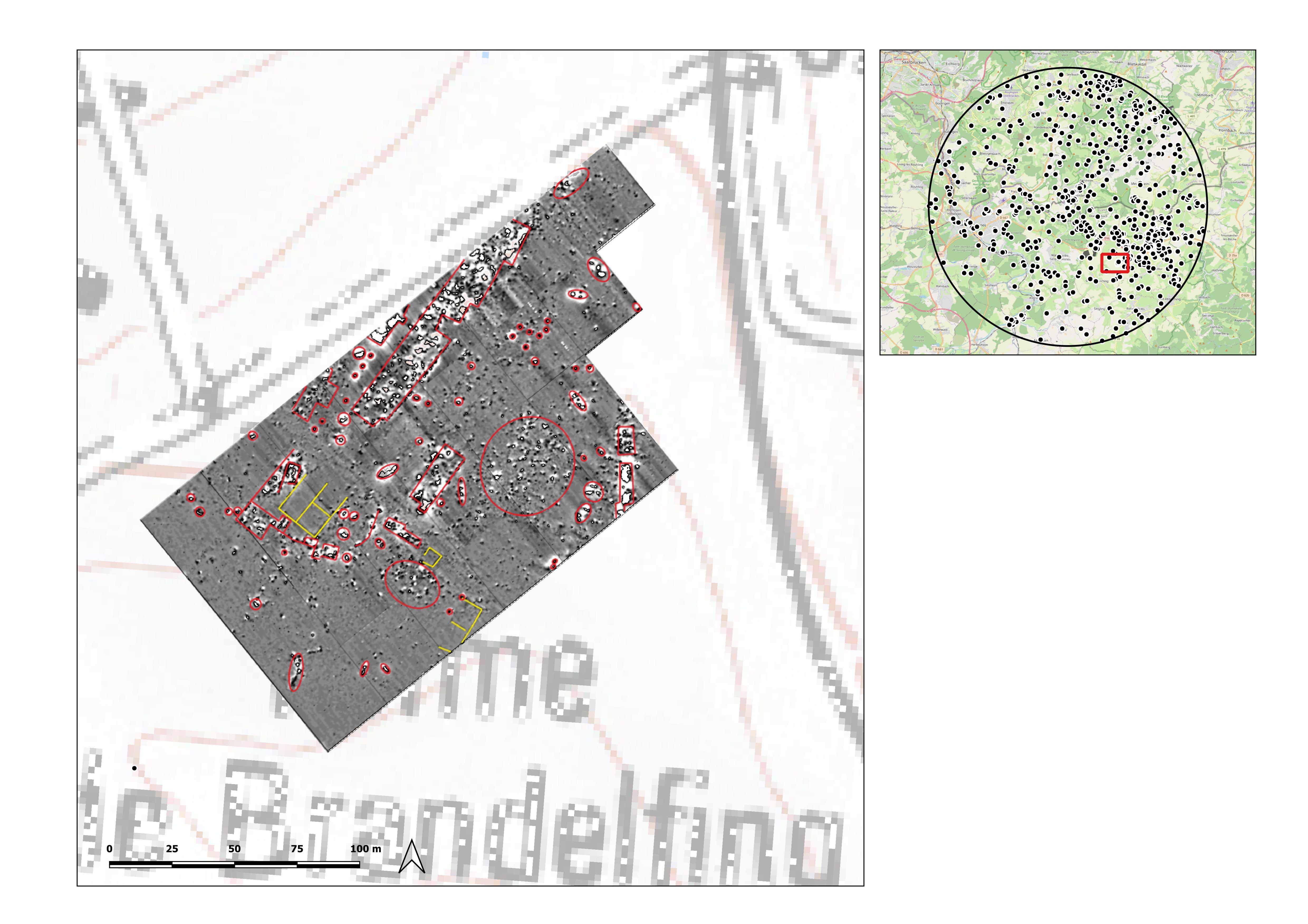 Figure 5. Measurement result of a geomagnetic prospection at Ferme de Brandelfing. Most of the recognisable structures are likely to be from the farm destroyed in the Second World War.
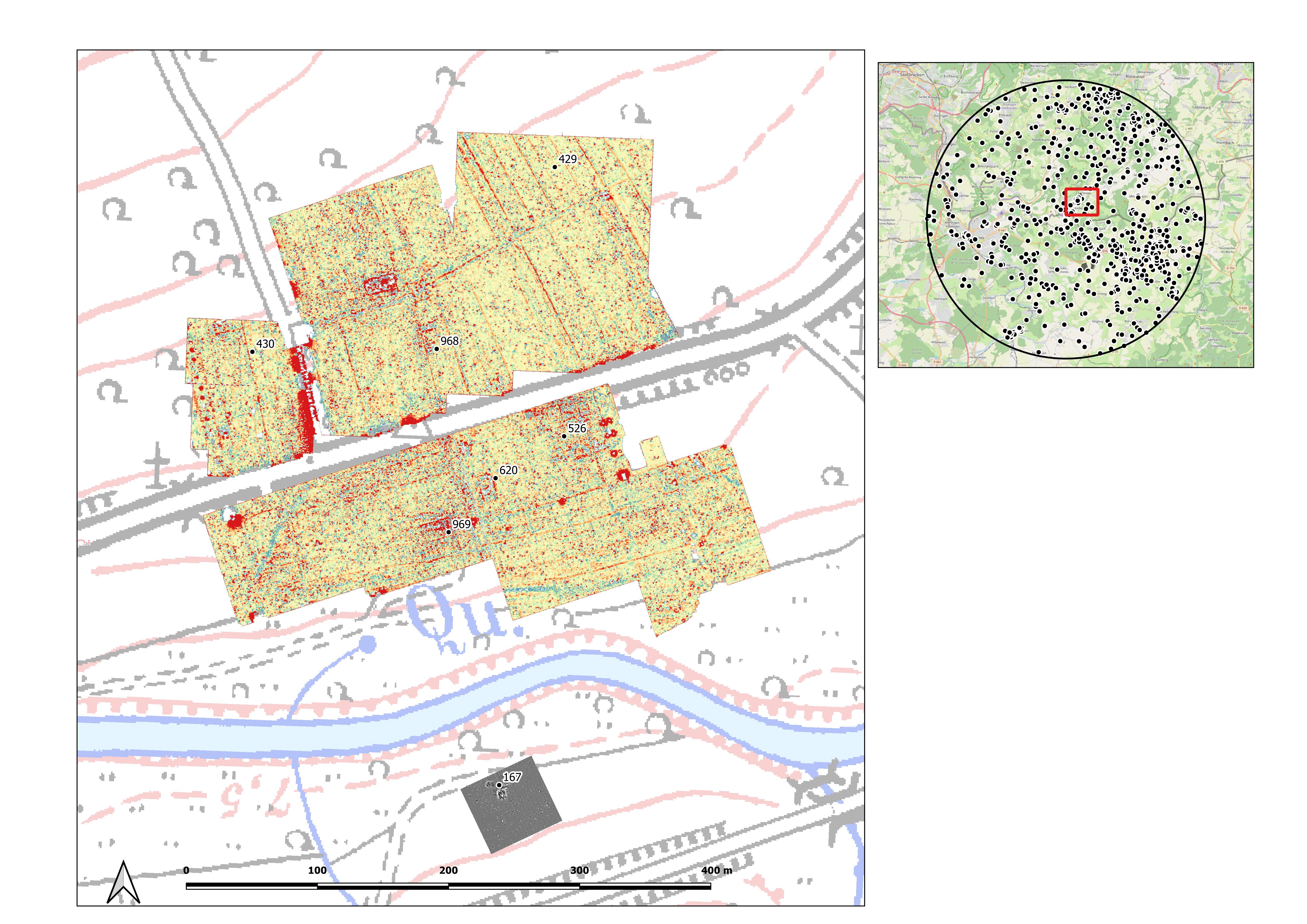 Figure 6. Reinheim, Horres. Site distribution and geophysics (geomagnetic and georadar methods).
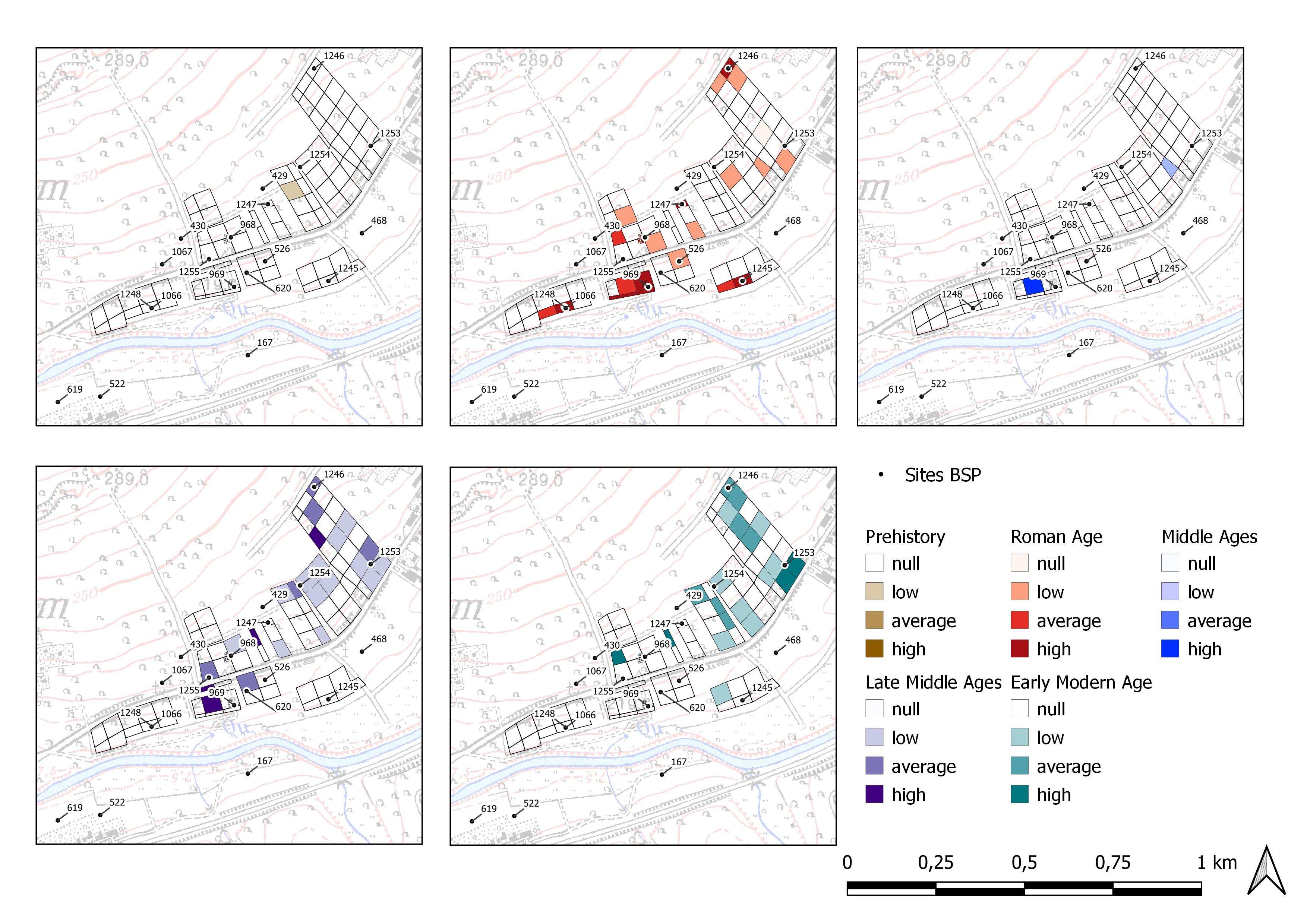 Figure 7. Reinheim, Horres. Prospection survey data density by chronology.
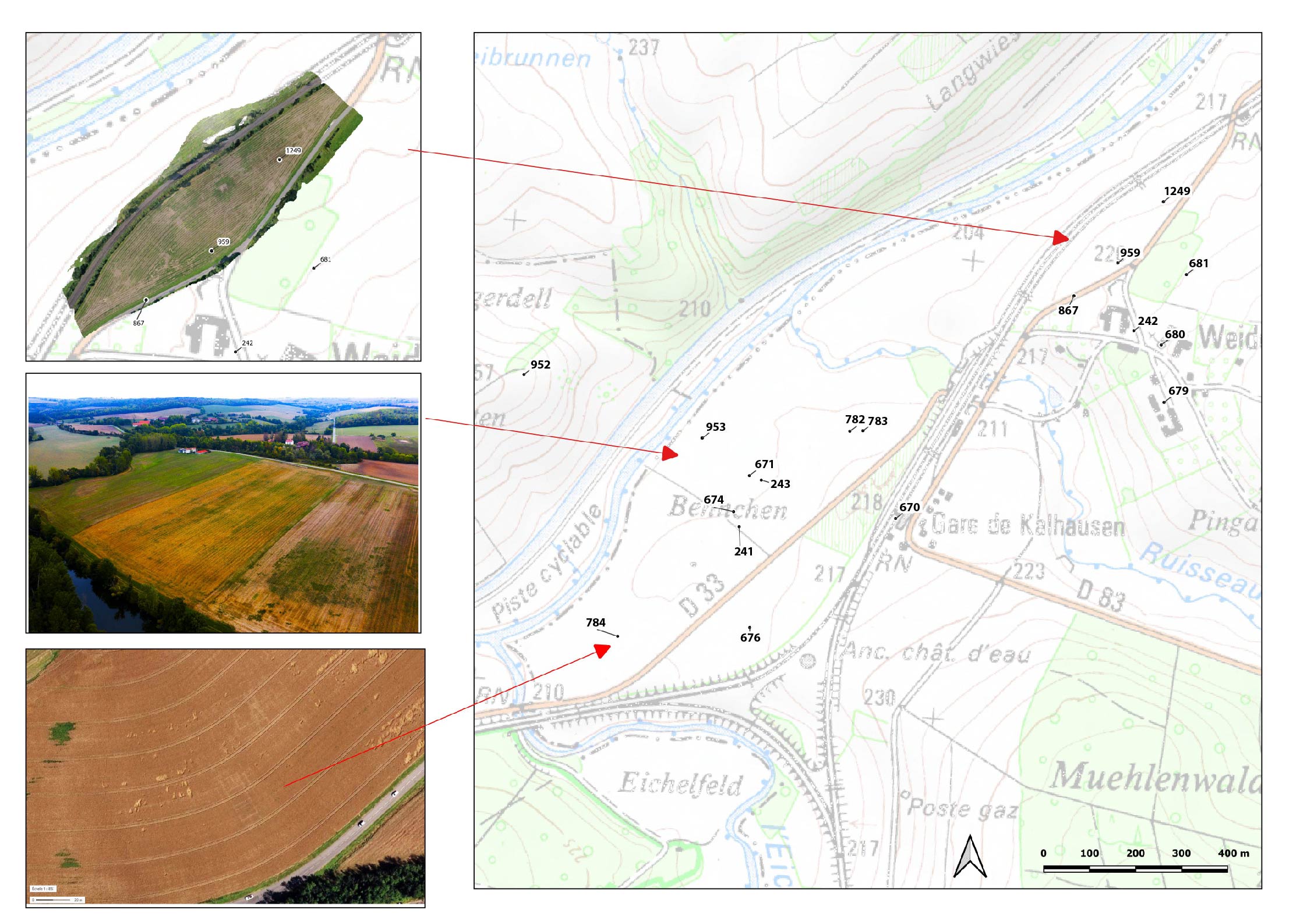 Figure 8. Kalhausen, Weidesheim. Site distribution and aerial (Géoportail, 2012) and drone photos.
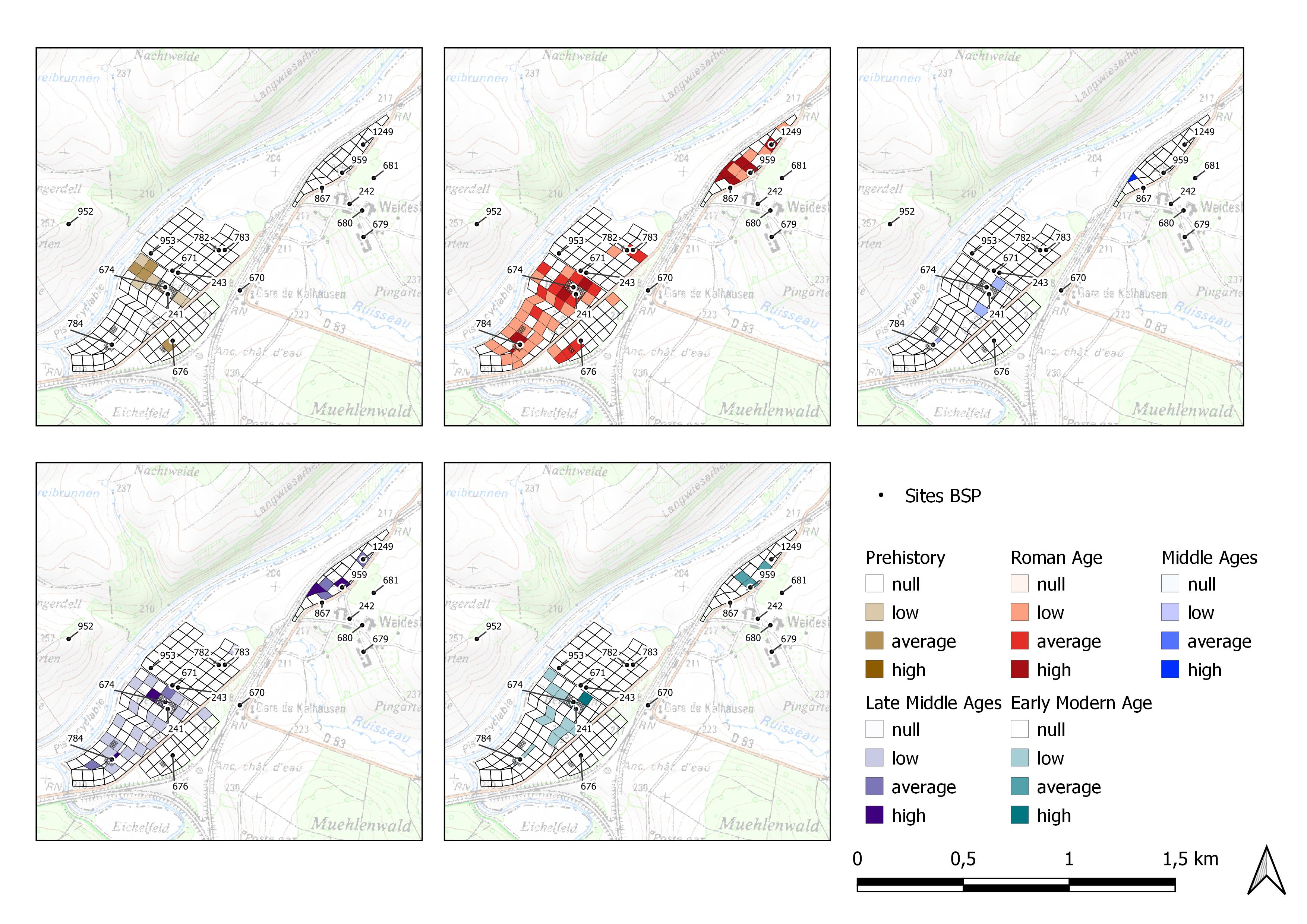 Figure 9. Kalhausen, Weidesheim. Prospection survey data density by chronology.
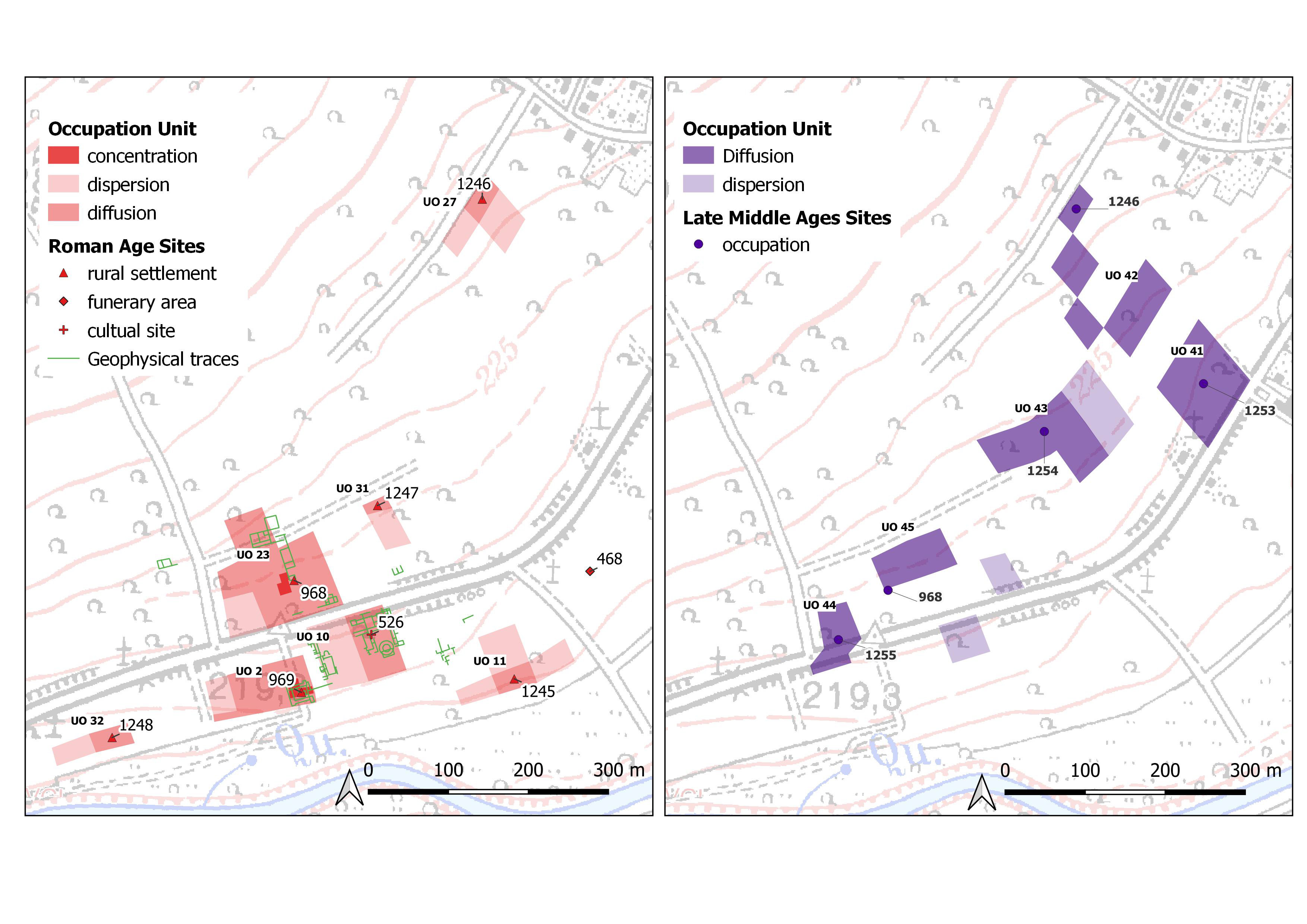 Figure 10: Reinheim, Horres. Definition of Roman (in red) and medieval (in purple) Occupation Units.
 Figure 11: Kalhausen, Weidesheim. Definition of Roman (in red) and medieval (in purple) Occupation Units.