
Traces around a capital: the hinterland of Ravenna through remote sensing
Remote sensing has been a fundamental tool in reconstructing the urban landscape of the abandoned Late Antique city of Classe, near Ravenna (Italy). However, much of Classe urban plan is not yet known, while the vast area north of Ravenna has been generally ignored for the presence of thick alluvial deposits. The number of freely available aerial and satellite images has increased exponentially in the past decade, yet no study has exploited these sources. The features mapped by analysing these sources allowed us to identify new structures in Classe and shed new light on water management and land-use practices around Ravenna.
Introduction
Aerial archaeology started as a new methodology in the late 19th century when photos were taken mainly to document excavated sites. The full potential of aerial photography for archaeological explorations was already evident in the first half of the following century (Piccarreta and Ceraudo 2000, 73–84; Musson 2013, 17–26). In the last decades, more and more archaeological features have been successfully mapped in a wide range of landscapes and sites, also facilitated by technological innovations such as satellite imagery (Fowler 2010) and, more recently, drone applications (Campana 2017; Adamopoulos and Rinaudo 2020).
One of the Italian sites where aerial archaeology has played a crucial role is the abandoned city of Classe, near Ravenna (Figure 1), where it helped shed light on the topography of both urban and suburban areas, and determined the identification of numerous buildings and infrastructures (i.e., streets, canals, bridges). The historical sources are not clear about the emergence of this centre, but decades of archaeological research have shown how a suburban area with scattered rural villas and necropoleis (Manzelli 2000) turned into a city equipped with walls and numerous basilicas (Augenti 2011). This drastic change happened from the 5th century CE, with the new role of Ravenna as the capital of the Western Roman Empire (Ravenna Da Capitale Imperiale a Capitale Esarcale2005) and with the emergence of Classe as one of the most important ports in the Mediterranean (Augenti 2019).
Much knowledge about this city and its hinterland derives from aerial archaeology, with the first applications already in the 1950s-60s (Convegno per lo Studio della Zona Archeologica di Classe a Mezzo dell’Aerofotografia1962), then further complemented in the first decade of the 21st century (Boschi 2008). These studies were also assisted by the analysis of satellite data and large-scale geophysical prospection (Boschi 2012b). In the meantime, several structures and buildings were excavated, including part of the Late Antique/Early medieval harbour infrastructures (Augenti and Cirelli 2012) and main religious complexes such as the monastery of San Severo (Augenti, Christie, and Laszlovszky 2017) and the basilica Petriana (Augenti, Boschi, and Cirelli 2010).
Despite all these investigations, much of the urban plan within the city walls is not yet known. Understanding the evolution of the extra-urban landscape also remains complex due to the environmental transformations that have characterised the area, such as coastal progradation, (artificial) river avulsions, and wetland reclamations.
Despite the successes achieved through aerial archaeology at Classe, no studies have exploited the new and free to use aerial and satellite images that have been made available during the past decade (Scardozzi 2016, 217). These new data may potentially help to fill in the empty areas within the city walls where buildings have not yet been found. These numerous but still largely unexplored sources had already been identified as potentially fundamental to integrating our knowledge of the hinterland of Ravenna (Abballe 2021). Together with historical images, these large data sets have already proven essential to map new fluvial traces in the Romagna plain, from protohistoric palaeochannels near Imola (Bologna) and Forlì (Forlì-Cesena) (Abballe and Cavalazzi 2021), and medieval flood events around Massa Lombarda (Ravenna) and Villafranca di Forlì (Forlì-Cesena) (Abballe 2022).
In addition, we wanted to assess whether this approach could also work in the Colmata del Lamonearea, a vast area north of the Ravenna that has been generally ignored for the presence of thick alluvial layers connected with the 19th-20th centuries massive land reclamation project (Nardi 1987). Here, the analysis of aerial and satellite photos aimed at identifying possible natural and/or anthropogenic traces predating the land reclamation programme, that might still be outcropping in geomorphological windows, namely areas not buried by later alluvial deposits. Specifically, the study of the coastal area near Ravenna also links with the Dante Pinewoods project promoted between 2019 and 2021 to investigate the landscape, climate, and environment in the coastland of Ravenna, with a specific focus on the pinewoods standing in the area from the Middle Ages onwards (Bortoluzzi and Cavalazzi 2022).
With these objectives in mind, this paper will discuss the new evidence mapped around Ravenna, especially in the poorly known area north of the city. Moreover, we will also present some novel evidence within and near the abandoned town of Classe, to the south of Ravenna, which sheds light on a large and articulated building near the so-called basilica Petriana.
M.A.
Methodology
The primary research consisted of systematically analysing all aerial photos and satellite images freely available online to identify crop and soil marks possibly related to buried natural landforms, such as palaeochannels and crevasse splays, and/or anthropogenic features like channels, canals, and buildings.1This work has been facilitated by many freely available digital sources offered by national and regional governmental bodies and private companies (Figure 2).
Notable is also the advanced state of digitalisation of topographical and geographical data provided by the Emilia-Romagna region through their Moka, a Content Management System for GIS data accessible online. Thanks to this platform, we were able to analyse two of the oldest cartographic sources covering the whole Ravenna province (and beyond), such as the Carta storica regionale o Carta Topografica Austriacafrom 1853 and the IGM Primo Impiantofrom 1877-95. These two sources also offer a reasonable resolution for the identification of the agrarian subdivisions existing at the time (second half of the 19th century), thus offering a first terminus ante quemfor the dating of some of the evidence identified.
Furthermore, the hinterland of Ravenna has been documented in historical maps since the 15th century. The most relevant sources are available in the local archives, such as the Archivio di Statoor the Archivio Storico Comunale. In particular, maps dated after the 17th century helped in interpreting some of the traces detected, especially the infrastructural ones, which are usually depicted in the cartography of the time.
M.A.
New data from aerial and satellite imagery
Intense urbanisation characterises the territory immediately around Ravenna so that rural areas are not frequent. Furthermore, massive reclamation works carried out in modern times (deeply) buried the palaeolandscapes both north of the urban centre and south of Classe (Fabbri 1987). These reasons led previous studies to ignore these areas, but novel data have emerged during our research, which we will summarise in the upcoming sections.
The southern suburb of Ravenna
The first area where several new features emerged is located between Ravenna and the Fiumi Uniti river, artificially created in the 18th century (Figure 1.C) (Bellardi 1741). Most of them became visible in Yandex imagery from 2021 and Google Earth imagery from September 2021 (Figure 3), where we can recognise a 3 m wide positive crop mark northeast of Via dei Poggi. In particular, in the Google Earth imagery the more luxuriant vegetative growth defines a possible squared feature,2approximately 30 m per side (Figure 3.C, no. 1). A smaller rectangular feature seems to connect to the southern side of the squared anomaly, again visible as a positive crop mark about 1.7-1.8 m thick, for a total perimeter of 12x5 m. In addition, a circular negative anomaly is visible just a few metres to the south, with a diameter of 5 m, plus a negative edge of circa 2-3 m that may refer to the same feature (Figure 3.C, no. 2).
Numerous positive anomalies are also recognisable throughout the field, about 2 metres wide and parallel to each other, with a southwest/northeast orientation (Figure 3.C, no. 3). These intersect almost orthogonally with at least three larger positive crop marks, between 2 and 3 m wide, also parallel to each other but oriented northwest/southeast. The first can be interpreted as agricultural channels due to their regularity, while the second set of evidence has a less precise shape. They may result from a difference in the local geology, corresponding to the presence of swales within a beach ridge, since these depressions favour water stagnation and, thus, vegetation growth.
Moreover, several other marks can be seen in the same imagery moving east towards Porto Fuori, both negative and positive (Figure 4). We want to draw attention to five of these. The first is a very large feature located between Via del Grano and Via Argine Sinistro Fiumi Uniti (Figure 4.A). It is recognisable as a negative soil mark in the eastern fields and as a complex anomaly in the western field. This second evidence is characterised by a darker (positive) mark on the south border, circa 5 m wide, while the remaining anomalies alternate between more luxuriant parts with less luxuriant ones. In total, this feature seems to be 60 m wide and at least 600 m long. Southwest, we can also see another feature that had already been mapped and interpreted as a chunk of the Panfilio canal (Boschi 2012b, id. 211), an artificial channel created around 1650 to connect Ravenna with the no longer existing Candiano harbour (Figure 4.B) (Boschi 2012b, 228).
Furthermore, according to written sources, the more ancient Badoreno channel was supposed to reach Porto Fuori, a waterway existing at least from the 6th century that connected Ravenna to the Po river to the north and the Adriatic sea towards the south (Novara 1994, 13–20; Gelichi 1991, 154). Several features have already been mapped west/northwest of Porto Fuori (Boschi 2012b, 250, tav. 1), including two interpreted as potential remains of the Badareno (Figure 4.C-D) (Boschi 2012b, id. 67 and 202). All these features have been linked to natural hydrography, but in the same Google image, we can clearly see an artificial channel circa 20 m wide with embankments of about 2/3 m, visible as negative crop marks (Figure 4.E). The same channel can be better seen in a MATTM aerial image of 6 August 2005, with the possible embankments highlighted as positive anomalies. In total, it can be followed for about 1 km, ideally connecting the modern Darsena to Porto Fuori.3
M.A., M.C.
The northern suburb of Ravenna
Moving northwards of Ravenna, the first set of novel evidence we present is located near Via S. Alberto, just on the city’s outskirts (Figure 1.B). Many positive crop marks are visible in the same Google Imagery from September 2021 (Figure 5). Most of them are circa 2 m wide and cluster near the crossroads between Via S. Alberto and Via Bisanzio. They may be interpreted as channels, and they define several parcels much smaller in size and with an utterly different orientation than the current ones (Figure 5.A). Some of the marks appear to be double, both in the fields south of the crossroad and about 600 m further north, where we can see similar features likely connected. These may be correlated to a larger feature to the west, about 15 m wide, recognisable in Esri images from both 18/08/2020 and 27/04/2022. Its sinuous shape could indicate a natural palaeochannel, from which the canals of the fields could potentially draw water.
A little further south, we can also partially reconstruct the course of an almost certainly artificial canal circa 10 m wide (Figure 5.B). The central one of the three identified chunks, mapped in Google imagery, appears as a negative soil mark, while negative crop marks correspond to the western chunk visible in MATTM images from 2000 and 2006. In the former, a potential third chunk is visible near the Mausoleum of Theodoric, with a north/south direction (Figure 5).
M.A.
Area of the Colmata and the Po of Primaro
Further north, dozens of km of canals have been mapped in the Colmata del Lamonearea (Figure 1.A),4which can be traced back to the various phases of this extensive reclamation programme promoted between the 19th and 20th centuries. However, several traces seem unrelated to this programme and, they may refer to more ancient features.
In the area that goes from the Reno river towards south, a special focus was put on the surroundings of Mandriole (Figure 6, no. 1), where chunks of a large palaeochannel connected to the medieval Po di Primarocan be observed (Abballe 2021). These are particularly visible in Google Earth imagery (3/2011 and 9/2021, Figure 6, letter A) and IGMI aerial photos from 1954 (Figure 6, letter B). The medieval monastery of S. Adalberto in Pereo was located upon this fluvial ridge (Figure 6, no. 2) (Novara 1994).
South of the Canale Destra Reno, within the Colmataarea, the imagery shows a network of embankments, channels and roads: they are visible on Google Earth imagery (3/2020; 4/2020; 4/2018; 3/2015; 3/2011) and aerial photographs (IGMI-Volo GAI 1954) as soil and crop marks, both positive and negative, depending on field-use or cultivation status (Figure 7.A).
Further south, in the area between the river Lamone and the hamlet of San Romualdo (Figure 7.H, no. 10), the number of anomalies increases. In particular, the oldest aerial photos, such as the IGMI-Volo GAI (1954) and RAF (1944) are the most significant. We will focus here mainly on two features that can be observed in these images (Figure 7.D). The first is a sinuous positive anomaly, approximately 650 m long, that may refer to a large fluvial meander (Figure 7.D, no. 2). It is visible in the IGMI 1954 flight west of S. Pietro in Armentario site (Figure 7.D, no. 3)5and north of S. Romualdo (Figure 7.H, no. 10). The second is a positive anomaly, probably the trace of a buried canal, approximately 20 m large and 2 km long, oriented north-south, visible in the flights IGMI-Volo GAI 1954 and RAF 1944, and Google Earth images from April 2020 and July 2017 (Figure 7.D, no. 4 and Figure 7.F, no. 8).
Moving east, the flights IGMI-Volo GAI 1954 and RAF 1944 show several interesting features near the archaeological site of S. Maria in Palazzolo (Figure 7.E, no. 6) (Augenti, Ficara, and Ravaioli 2012, 271–72, id. 274), a monastery founded in the 9th century on the site previously occupied by a rural church and a palace (Bermond Montanari 1983; Pasquali 1983), which Agnellusattributes to Theodoric, king of the Ostrogoths (Liber Pontificalis RavennatisA, 303). The first is a sinuous trace near the dune ridges southwest of the site, approximately 1.1 km long, which appears both as negative soil and crop marks (Figure 7.E, no. 7). The second is a network of agrarian divisions, still clearly visible, in the area east of Palazzolo (Figure 7.F, no. 9). The third, in this same area, is a negative anomaly, approximately 500 m long, a few metres large and with an irregular path (Figure 7.E, no. 5). Finally, tens of small circular anomalies are arranged regularly in parallel rows (Figure 7.B-C).
Moreover, moving towards Ravenna (Figure 7.G), it is possible to detect several positive and negative anomalies in Google Earth images from 2021. These rectilinear features are perpendicular to the nearby beach ridge, which is a prosecution of the same identified near Classe and generally dated to Late Antiquity (Abballe 2021, 39).
M.C.
The urban area of Classe
As already mentioned, the site of Classe has been investigated extensively and with various methods. The availability of new aerial and satellite images can fill the gap of many ‘empty’ areas within the urban walls (Figure 1, D). Among these, the Google Earth images of September 2021 have been the most fruitful (Figg. 8-9).
Most of the new evidences are clustered around the site of the so-called basilica Petriana (Figure 8, no. 3), a palaeo-Christian church investigated by excavation and geophysical investigation (Abballe 2021, 39). The basilica itself was already visible in several aerial and satellite images (Boschi 2012b, 205, fig. 6.2.2.1). Still, we can see the building north of it, previously known only thanks to magnetometry (Boschi 2012a, 224, fig. 5.), for the first time through remote sensing. The plan of the basilica matches perfectly with the previous reconstruction, while we can also see for the first time an unknown part of the northern building, namely its northern corner (Figure 8, no. 2), which was not visible in the geophysical results. This difference could indicate a distinct state of preservation of the structures. Unfortunately, the entire eastern half of this rectangular building is not visible in the recent satellite images, concealed by a change of use of the field.
However, the most interesting data concerns a building located southeast of the Petriana, already identified through geophysics but whose plan remained unclear (Boschi 2012a, 224, fig. 5.). Numerous negative crop marks define part of a central plan building, composed of several apses and octagonal rooms connected to a central room (Figure 8, no. 4). Moreover, a structure with a Latin cross planimetry is also clearly visible at the southwest corner. The central room is circa 22-25 m large, while the whole building is at least 65-70 metres long.
A positive crop mark can be noted close to it, in northern direction, already identified as the harbour-canal of Classe (Figure 8, no. 1) (Boschi 2012b, 223). The basilica and the nearby buildings seem to be aligned to this channel.
Finally, the same imagery also sheds more light on the urban and extra-urban areas, east of the basilica Petriana (Figure 9). The 2021 imagery shows a negative anomaly, corresponding to the already mapped urban wall circuit (Figure 9, no. 1), which was partially excavated (Lepore and Montevecchi 2009). Furthermore, rectangular and linear traces are visible just inside the walls, appearing as negative vegetation marks and suggesting the possible presence of additional archaeological remains also next to the city walls (Figure 9, no. 2). Around 85 m further east, a negative crop mark can be recognised, mostly likely a palaeochannel oriented approximately north-south, almost parallel to the city walls circuit (Figure 9, no. 3).
Further eastwards, other channels and a series of positive crop marks oriented west/east, circa 2 m wide and parallel to each other are visible (Figure 9, no. 4). They are perpendicular to the Late Antique beach ridge (Abballe 2021, 39), whose swales are clearly visible as positive crop marks. Approximately in the middle of the series of channels, probably related to agricultural activities, a more clearly defined (primarily positive) feature is visible, having the same orientation as the smaller channels. This larger evidence may have a continuation about 20 m further south, defining a possible channel about 35 m wide in total (Figure 9, no. 5).6Currently, we have not been able to find existing data to propose a dating (and function) for this large double feature, so targeted investigations will be needed.
M.C.
The southern hinterland of Classe
Several dozens of already known natural and anthropogenic features south of Classe (Figure 1.E) (Boschi 2012b, 252–56, tavv. 3-7), where confirmed through our re-analysis. New features were particularly evident in an Esri image from August 2018, and they cluster in a modern parcel south of the Classe junction along the SS16 Via Classicana (Figure 10).
The main feature is a negative crop mark about 630 m long and 5 m wide, characterised by darker edges, namely positive crop marks (Figure 10.A). This feature is mostly straight, with a northwest/southeast direction, but it clearly has a sinuous path in the southern part. The meandering of the southern section seems to contradict the previous interpretation as a road axis (Boschi 2012b, id. 131), when the dark outer edges were interpreted as lateral channels. Thus, we propose to interpret these features as a large swale with two more possible parallel ones, one on each side. Their presence is perfectly compatible with the beach ridge already mapped (Boschi 2012b, id. 217), responsible for the general vegetation growth difficulty. However, there are numerous positive crop marks, primarily perpendicular to both ridge and swales, perfectly compatible for orientation with the channels already mapped immediately to the west (Boschi 2012b, id. 130). This correspondence is further confirmed by the presence of quadrangular areas, of about 25-30 m per side, identified in the southeast corner of the field and also recognised about 500 m further west (Figure 10.B). Thus, the presence of these small square plots seems to characterise this field, differentiating it from those nearby where only parallel channels were mapped (Boschi 2012b, 253, tav. 4).
M.A.
Discussion
The suburbs of Ravenna and Classe
The interpretation of all river evidence, probable artificial channels and possible agricultural subdivisions mapped both north and south of Ravenna is by no means a simple task. This difficulty is due both to the geomorphological transformations that have affected the area, which have never been studied in detail and to the small number of known archaeological sites outside the urban areas (CPA-RA). We will focus on three locations where the intersection of previous (geo)archaeological data and the analysis of historical cartography allows us to narrow down the chronological framework for the creation of the features mapped by remote sensing.
From the north, the first area is located between Via S. Alberto and Via Bisanzio, just outside Ravenna (Figure 5.A). The system of fields identified here does not appear in the aerial photographs nor in the 19th-century maps analysed, suggesting an earlier date. Moreover, the only certain archaeological data in the vicinity suggests that the Roman level is at a depth of about 2.5 m (CPA-RA, SA001). Therefore, targeted investigations will be needed to understand whether we are dealing with a peculiar medieval or early modern parcelling and if it was associated with specific land use.
The second area is located near the Mausoleum of Theodoric (Figure 5, no. 2) and concerns the identification of a possible canal that appears to run not too far from it, in a north/south direction (Figure 5.B). Written sources indicate that the Badareno ran near this site before reaching Porto Fuori, southeast of Ravenna (Fabbri 1991, 18). Traces of this canal may also have been found during the park’s landscaping (Venturini 2003), which led to the discovery of a ship dating to the 5th century (Maioli and Medas 2010). It is difficult to say whether the mapped feature is really the trace of this vital waterway and, if so, whether it belongs to the first phase of activation/creation during Late Antiquity/Early Middle Ages, or to later resettlements that may have been necessary after the Colmatareclamation (see section 4.3).
Finally, the third area is the southernmost one, south of the Basilica of Sant’Apollinare in Classe (Figure 1.E). As mentioned above, numerous natural and anthropogenic evidence have been mapped in a field south of the Via Adriatica (Figure 10). Among these, the most enigmatic ones are certainly the small quadrangular squares that emerged both in this field and previously mapped further west. These do not appear in the aerial photographs, and it is evident from the 19th-century cartography that the area was occupied at the end of the century by enormous paddy fields, identified as ‘Risaia Munghina’ in the IGM Primo Impianto(Pancino 2000). These small squares could correspond to internal subdivisions of the rice fields, whose traces have now almost completely disappeared due to the change in land use.
M.A.
Classe
The main question raised from our discoveries in the site of Classe relates to the interpretation of the complex building located southeast of the basilica Petriana (Figure 11) (Augenti 2012, 55; Boschi 2012a; 2012b, 201–3). Assuming that the identification of the structures excavated between 2004 and 2008 with the basilica Petriana is correct, as no epigraphs or similar clear evidence have emerged to confirm the dedication of the building, we may tentatively recognise this large building with the baptistry of the Petriana, mentioned in the medieval sources. Agnellus describes this baptistry as ‘wonderful in size, with doubled walls’ – probably an ambulacrum(Testi Rasponi 1924, 2, 3:148, n. 2) – ‘and high walls, built with mathematical art’ (Liber Pontificalis RavennatisA, 312; Liber Pontificalis RavennatisB, 161). He also adds that two monasteria,St. Matthew and St. James, were joined to the sides of the baptistry (Liber Pontificalis Ravennatis A, 336; Liber Pontificalis Ravennatis B, 203). The Latin cross-shaped building can be one of them. However, Agnellus’s words seem to go against this hypothesis since, according to him, the baptistry was squared-shaped (tetragonus) and not octagonal (Liber Pontificalis Ravennatis A, 325; Liber Pontificalis Ravennatis B, 183: Agnellus specifies that the baptistry included a pars virorumand a pars mulierum), as frequently happened in the Ravenna area.7Indeed, most of the shapes recognised in the satellite image seem to be octagonal. Anyway, Agnellus may simply refer to the exterior plan of the building at ground level, as pointed out by Testi Rasponi (Testi Rasponi 1924, 2, 3:148, n. 2). If this were the case, the building would have appeared partially as a square, similar to the still-existing Neonian or Arian baptisteries (the latter, less clearly) in Ravenna.8
If these traces within the walls certainly refer to buildings, additional structural remains may be located immediately north of the Fiumi Uniti river (Figure 3). We saw how positive crop marks define a rectangular enclosure, associated with a circular anomaly with a diameter of circa 8 m. At the moment, they seem not to be related to the many natural and agricultural traces seen in the parcel, and we cannot exclude that they refer to buried structures. No archaeological remains are known for this parcel, which is located between the settlements of Classe and Cesarea (Figure 1). However, the area seems to be important, since medieval and modern cartography places the via Romanahere, a road connecting Ravenna to Classe and the nearby pinewood (Boschi 2012b, 50–51, 243, 248). Furthermore, previous studies located the monasteriumof the saints Johannisand Stephaniad Titumor ad Pinumin this area, which according to the written sources existed between the 6th and 11th centuries.9So far, it is impossible to associate with certainty the marks identified to this church, but this can be a starting point to address further investigations.
M.C.
Ravenna northern wetlands
The most interesting features located north of Ravenna tell us about the long-term interaction between humans and water in a very hostile landscape.
The main evidence of the area can be strongly related to the Padoreno channel (Figg. 7.A and 12, no. 3 ). This infrastructure was part of the network of canals that linked Ravenna and its harbours to the Po river during the Middle Ages (Novara 1994, 13–20; Gelichi 1991, 154). Still, the Padoreno may have been created during Late Antiquity to replace the Fossa Augusta, an artificial canal connecting Ravenna to the Po river.10The preliminary interpretation of these traces with this important channel is possible thanks to abundant historical cartography, which depicts it from the 16th century onwards. However, we must underline that the earlier maps, such as the so-called Ginanni map (Ginanni 1774) or the map of the Bonifica Gregoriana (1585, Carrari 2009, fig. 34) draw the Badareno channel in an approximate way, without any real topographical precision, as commonly happens in such cartographic representation. Still, the anomalies detected find a sufficiently accurate reference in the more recent cartography, such as the Carta storica regionale orCarta Topografica Austriaca(1853) and the IGM Primo Impianto(1877-95), although the Lamone flood in 1839 and the following land reclamation process of the Colmata might have slightly change the Badoreno route.
In addition to this, a large meander (Figure 12, no. 4) in the area of S. Romualdo seems relevant since it is located immediately west of the site of the church of S. Pietro in Armentario (Novara 1994, 18–21, n. 5) (Figure 12, no. 1). Only further investigations may clarify if this feature relates to the Colmata process or the premodern activities of the Lamone river. So far, we can underline the proximity between this feature and the presence of a large channel cutting through the Iron Age/Roman period beach ridge, identified in the regional geological cartography (Preti 2002, Foglio 223, Tetto delle sabbie litorali del Subsintema di Ravenna). In this cartography, this channel was mapped up to the area of Piangipane, and further southwest towards Russi. Thus, we can relate it to the premodern course of the Lamone, attested exactly in this area, at least from the Early Middle Ages (Abballe 2021, 42–43).
Rich in traces is also the sector of the hinterland of Ravenna between Palazzolo and the Ravenna suburb. This area was historically included in the island of Palazzolo monastery. Here, a series of anomalies are linked to the agricultural exploitation of the area: first, the grid of squares is a trace of the paddies for the rice cultivation, carried out probably during the Colmata period around the end of the 19th century (Figure 12no. 5); second, the regular pattern of small circular anomalies is probably a trace of the cultivated pinewood of Palazzolo (Figure 7.B-C); finally, an irregular negative anomaly seems interpretable as a trail (Figg. 7, no. 5 and Figure 12, no. 6). Slightly east of the Palazzolo site, where the Late Antique and medieval shoreline was, the irregular anomaly oriented north-south is probably the trace of a swale (Figure 12, no. 7).
Finally, we detected the evidence of the beach ridges as well as a probably premodern agrarian division northeast of Ravenna (Figure 7.G). The parcels typology looks similar to those detected in the area of Classe, on the Late Antique shoreline (Boschi 2012b, 144, id. 74).
M.C.
Conclusion
Around ten years ago, Federica Boschi pointed out the necessity to promote frequent and repeated reconnaissance flights around Classe. She judged this approach as the only way to overcome the challenges brought by the local geomorphological complexity and better understand the landscape around this prominent archaeological site, as well as Ravenna itself (Boschi 2012b, 62; Cavalazzi 2020). Indeed, she applied to the Ravenna area a definition already used for some British regions, that is ‘difficult and clay soil landscapes’ (Mills 2007).
Unfortunately, this call went unheard, but our research has demonstrated the value of this approach leading to new knowledge in the extremely dynamic landscape around Ravenna. We used sources not meant for archaeological research, which were often taken also in not ideal periods (i.e., not during the summer season). Still, their large number allowed us to obtain meaningful data on water management and land-use practices, as well as possible structures within the abandoned town of Classe.
However, it is evident that we will need more systematic and multidisciplinary research to truly unlock the multilayered landscape around Ravenna, shaped by rivers and sea but on which we can recognise numerous anthropogenic traces. To reveal and understand all these traces, we will need extensive surveys (Campana 2019), combined with remote sensing, geophysics, and geoarchaeological investigations. The latter must be aimed both at the dating of the various natural and artificial palaeochannels, as done in the similar port city of Portus, near Rome (Salomon et al. 2020), and at systematically reconstructing the reclamation processes documented in both written sources and historical cartography, as done inland of Ravenna (Abballe 2022; Abballe, Cavalazzi, and Fiorotto 2022).
This need becomes more urgent looking at the profound changes affecting the Ravenna coastland, with landforms transformed or even erased by agricultural activities (Boschi 2012b, 27; Berti Ceroni and Smurra 2005, 23), increasing urbanisation pressure and a landscape equilibrium threatened by both human activities and climate change. In this situation, more systematic and multidisciplinary research will collect new and precious data before they are lost forever. Moreover, they will provide the local communities of the hinterland of Ravenna with the historical and cultural instruments to face the challenges of this century in terms of climate change and landscape management, urgencies that are growing day by day.
M.A., M.C
References
Written sources
- Carrari, Vincenzo. 2009. Istoria Di Romagna. Vol. 2: Dalle Signorie capitaniali alla liquidazione degli stati cittadini (1326-1522). Edited by Umberto Zaccarini. Ravenna: Libreria Antiquaria Tonini.
- Liber Pontificalis Ravennatis A =Ravenna, Agnellus de. 1878. ‘Agnelli Liber Pontificalis Ecclesiae Ravennatis’. In Monumenta Germaniae Historica, Scriptores Rerum Langobardicarum et Italicarum Saec. VI-IX. Edited by Oswald Holder-Egger, 265–391.
- Liber Pontificalis Ravennatis B=Liber pontificalis ecclesiae Ravennatis 2006. Edited by Deborah Mauskopf Deliyannis. Turnhout: Brepols.
- Testi Rasponi, Alessandro. 1924. Codex Pontificalis Ecclesiae Ravennatis. Vol. 2, 3. Rerum Italicarum Scriptores. Nuova Edizione. Bologna. http://www.archive.org/details/p3rerumitalicarums02card.
- Abballe, Michele. 2021. ‘Fiumi, Valli e Litorali Tra Lamone e Savio Dal Periodo Romano All’Età Medievale’. In Una Terra Antica. Paesaggi e Insediamenti Nella Romania Dei Secoli V-XI, edited by Paola Galetti, 35–48. Storie Di Paesaggi Medievali 4. Sesto Fiorentino: All’Insegna del Giglio.
- Abballe, Michele. 2022. ‘Geoarchaeological Mapping of Medieval Wetlands and Their Reclamation in the Hinterland of Ravenna: Two Case Studies from Massa Lombarda (RA) and Villafranca Di Forlì (FC)’. ArcheoLogica Data2: 42–62. https://doi.org/10.13131/unipi/2785-0668/n4tg-xz64.
- Abballe, Michele, and Marco Cavalazzi. 2021. ‘Morphometric Analysis for Geoarchaeological Research: From Testing Different Methods to Results Verification in the Romagna Plain’. Archeologia e Calcolatori 32 (1): 117–36. https://doi.org/10.19282/ac.32.1.2021.07.
- Abballe, Michele, Marco Cavalazzi, and Celeste Fiorotto. 2022. ‘Integrated Approaches to Understanding Complex Long-Term Reclamation Processes in the Hinterland of Ravenna (Italy)’. Journal of Wetland Archaeology, June, 1–31. https://doi.org/10.1080/14732971.2022.2083798.
- Adamopoulos, Efstathios, and Fulvio Rinaudo. 2020. ‘UAS-Based Archaeological Remote Sensing: Review, Meta-Analysis and State-of-the-Art’. Drones4 (3): 46. https://doi.org/10.3390/drones4030046.
- Atti del Convegno internazionale di studi sulle antichità di Classe. Ravenna, 14-17 ottobre 1967.1968. Ravenna: A. Longo.
- Augenti, Andrea, ed. 2011. Classe. Indagini Sul Potenziale Archeologico Di Una Città Scomparsa. Studi e Scavi 27. Bologna: Ante Quem.
- Augenti, Andrea. 2012. ‘Classe: Archaeologies of a Lost City’. In Urbes Extinctae. Archaeologies of Abandoned Classical Towns, edited by Neil Christie and Andrea Augenti, 45–76. London: Routledge.
- Augenti, Andrea. 2019. ‘I Magazzini Del Porto Di Classe’. Antiquité Tardive27 (January): 159–75. https://doi.org/10.1484/J.AT.5.119550.
- Augenti, Andrea, Federica Boschi, and Enrico Cirelli. 2010. ‘Il Sito Della Basilica Petriana a Classe: Dalla Diagnostica Allo Scavo’. Ocnus | Quaderni Della Scuola Di Specializzazione in Beni Archeologici18: 103–16.
- Augenti, Andrea, Neil J. Christie, and József Laszlovszky. 2017. La Basilica Di San Severo a Classe. Scavi 2006. Vol. 16. Collana DiSCi. Archeologia. Bologna.
- Augenti, Andrea, and Enrico Cirelli. 2012. ‘From Suburb to Port: The Rise (and Fall) of Classe as a Centre of Trade and Redistribution’. In Rome, Portus and the Mediterranean, edited by Simon Keay, 205–21. Archaeological Monographs of the British School at Rome 21. London: British School at Rome.
- Augenti, Andrea, Marilisa Ficara, and Enrico Ravaioli. 2012. Atlante Dei Beni Archeologici Della Provincia Di Ravenna. Vol. 1: Il Paesaggio Monumentale Nel Medioevo. Studi e Scavi 35. Bologna: Ante Quem.
- Bellardi, Filippo Diego. 1741. Ragguaglio istorico della diversione dei duo fiumi il Ronco, ed il Montone della città di Ravenna. Bologna: Sassi, Clemente Maria.
- Bermond Montanari, Giovanna. 1983. ‘La Zona Archeologica Di Palazzolo’. Corsi Di Cultura Sull’Arte Ravennate e BizantinaXXX: 17–21.
- Berti Ceroni, Laura, and Rosa Smurra. 2005. A sud-est di Ravenna. Cesarea e Classe fra antichita e Medioevo. Dalla ricerca scientifica alla fruizione turistica. Roma: Viella.
- Bortoluzzi, Daniele, and Marco Cavalazzi. 2022. ‘La Pineta Di Ravenna Ai Tempi Di Dante: Un Approccio Interdisciplinare’. In Selve Oscure e Alberi Strani: I Boschi Nell’Italia Di Dante, edited by Paolo Grillo, 217–34. I Libri Di Viella 413. Roma: Viella.
- Boschi, Federica. 2008. ‘Archeologia e Fotografia Aerea a Classe: Indagini 2003-2008’. Archeologia Aerea III: 93–100.
- Boschi, Federica. 2012a. ‘Magnetic Prospecting for the Archaeology of Classe (Ravenna)’. Archaeological Prospection19 (3): 219–27. https://doi.org/10.1002/arp.1430.
- Boschi, Federica. 2012b. Tracce Di Una Città Sepolta. Aerofotografia e Geofisica per l’archeologia Di Classe e Del Suo Territorio. Studie e Scavi 34. Bologna: Ante Quem.
- Bovini, Giuseppe. 1964. Storia e architettura degli edifici paleocristiani di culto di Ravenna. Bologna: R. Pàtron.
- Campana, Stefano. 2017. ‘Drones in Archaeology. State-of-the-Art and Future Perspectives’. Archaeological Prospection 24 (4): 275–96. https://doi.org/10.1002/arp.1569.
- Campana, Stefano. 2019. ‘‘Emptyscapes’ and Medieval Landscapes: Is a New Wave of Research Changing Content and Understanding of the Rural Archaeological Record?’ In Mediterranean Landscapes in Post Antiquity, edited by Sauro Gelichi and Lauro Olmo-Enciso, 64–83. New Frontiers and New Perspectives. Archaeopress. https://doi.org/10.2307/j.ctvndv6wx.8.
- Cavalazzi, Marco. 2020. ‘‘Looking through the Keyhole’: Problems and Research Strategies for Landscape Archaeology in an Alluvial Plain with a High Rate of Vertical Growth. The Case of Bassa Romagna and South-Eastern Po Valley’. Groma. Documenting Archaeology, no. 5. https://groma.unibo.it/cavalazzi-looking-through-the-keyhole.
- Ceraudo, Giuseppe. 2013. ‘Aerial Photography in Archaeology’. In Good Practice in Archaeological Diagnostics: Non-Invasive Survey of Complex Archaeological Sites, edited by Cristina Corsi, Božidar Slapšak, and Frank Vermeulen, 11–30. Natural Science in Archaeology. Cham: Springer International Publishing. https://doi.org/10.1007/978-3-319-01784-6_2.
- Convegno per lo Studio della Zona Archeologica di Classe a Mezzo dell’Aerofotografia. 1962. Convegno Per Lo Studio Della Zona Archeologica Di Classe a Mezzo Dell’aerofotografia : Promosso Dal Lions Club Di Ravenna Nei Giorni 29-30 Aprile 1961. Faenza: Stab. grafico f.lli lega.
- Deichmann, Friedrich Wilhelm. 1976. Ravenna: Hauptstadt Des Spätantiken Abendlandes. Vol. 2.2. Die Bauten des Julianus argentarius; übrige Kirchen. Wiesbaden.
- Fabbri, Paolo. 1987. ‘Le Bonifiche d’età Moderna’. In Costruire Un Territorio: Cartografia e Fotografia Delle Bonifiche Ravennati, Longo Editore, 7–69. Ravenna.
- Fabbri, Paolo. 1991. ‘Il Controllo Delle Acque Tra Tecnica Ed Economia’. In Storia Di Ravenna, edited by Antonio Carile, 2 (1): 9–25. Venezia: Marsilio.
- Farioli Campanati, Raffaella. 1983. ‘Edifici Paleocristiani Di Classe: Stato Attuale Delle Ricerche e Problemi’. In Ravenna e Il Porto Di Classe: Venti Anni Di Ricerche Archeologiche Tra Ravenna e Classe, edited by Giovanna Bermond Montanari, 23–51. Fonti e Studi 7. Imola: Saterno.
- Fowler, M.J.F. 2010. ‘Satellite Imagery and Archaeology’. In Landscapes through the Lens. Aerial Photographs and Historic Environment, edited by David C. Cowley, R.A. Standring, and M.J. Abicht, 99–110. Oxford: Oxbow Books.
- Gelichi, Sauro. 1991. ‘Il Paesaggio Urbano Tra V e X Secolo’. In Storia Di Ravenna, edited by Antonio Carile, 2 (1): 153–65. Venezia: Marsilio.
- Ginanni, conte Francesco. 1774. Istoria civile e naturale delle Pinete Ravennati nella quale si tratta della loro origine, situazione, fabriche antiche, e moderne, terre molteplici, acqua, aria, fossili, vegetabili, animali terrestri, volatili, acquatili, anfibj, insetti, vermi, & c. Roma: nella Stamperia di Generoso Salomoni. https://books.google.it/books?id=CDsDAAAAYAAJ.
- Lepore, Giuseppe, and Giovanna Montevecchi. 2009. ‘Classe (Ravenna), Suburbio’. Ocnus | Quaderni Della Scuola Di Specializzazione in Beni Archeologici17: 155–57.
- Maioli, Maria Grazia, and Stefano Medas. 2010. ‘Il relitto del Parco di Teodorico Ravenna (V sec. d.C.) e l’evoluzione costruttiva degli scafi tra la tarda antichità e l’alto medioevo nel Mediterraneo’. In Navis 4. Archeologia, Storia, Etnologia Navale. Atti del I Convegno Nazionale, Cesenatico, Museo della Marineria (4-5 aprile 2008), edited by Stefano Medas, Marco D’Agostino, and Giovanni Caniato, 311–14. Venezia: Edipuglia.
- Manzelli, Valentina. 2000. Ravenna. Roma.
- Mills, Jessica. 2007. ‘Surveying the Claylands: Combining Aerial Survey and Fieldwalking Methods in Identifying Archaeological Sites on Difficult Soils’. In Populating Clay Landscapes, edited by Jessica Mills and Rog Palmer, 132–46. Stroud: Tempus.
- Muscolino, Cetty, Antonella Ranaldi, and Claudia Tedeschi. 2011. Il Battistero Neoniano. Uno Sguardo Attraverso Il Restauro. Ravenna.
- Musson, Chris. 2013. ‘Flights into the Past’. In Flights into the Past: Aerial Photography, Photo Interpretation and Mapping for Archaeology, edited by Chris Musson, Rog Palmer, and Stefano Campana, 11–155. Occasional Publication of the Aerial Archaeology Research Group 4. Heidelberg: AARG – Arcland.
- Nardi, S. 1987. ‘Le Bonifiche Nel Secolo XIX e La Cassa Di Colmata Del Lamone’. In Costruire Un Territorio: Cartografia e Fotografia Delle Bonifiche Ravennati, Longo Editore, 71–83. Ravenna.
- Novara, Paola. 1994. S. Adalberto in Pereo e La Decorazione in Laterizio Nel Ravennate e Nell’Italia Settentrionale (Secc. VIII-XI). Documenti Di Archeologia 3. Mantova: SAP Società
archeologica s.r.l. - Pancino, Claudia. 2000. Conselice nell’Ottocento. Gioco di risaie e vocazioni urbane. Ravenna: Longo Editore Ravenna.
- Pasquali, Gianfranco. 1983. ‘Economia e Paesaggio Rurale Di ‘Deserta’ Alle Porte Di Ravenna: L’isola Litoranea Di Palazzolo Dal VI al XIV Secolo’. Atti e Memorie Della Regia Deputazione Di Storia Patria per Le Provincie Di Romagna34: 131–61.
- Piccarreta, Fabio, and Giuseppe Ceraudo. 2000. Manuale di aerofotografia archeologica. Metodologia, tecniche e applicazioni. Bari: Edipuglia.
- Preti, Domenico. 2002. Carta Geologica d’Italia Alla Scala 1:50.000, Foglio 223, Ravenna.
- Ravenna Da Capitale Imperiale a Capitale Esarcale. 2005. Vol. 17. 2 vols. Atti Dei Congressi. Centro Italiano Di Studi Sull’Alto Medioevo. Spoleto: Fondazione Centro Italiano di Studi sull’Alto Medioevo.
- Salomon, Ferréol, Ludmilla Lebrun-Nesteroff, Jean-Philippe Goiran, Giulia Boetto, Antonia Arnoldus-Huyzendveld, Paola Germoni, Alessandra Ghelli, Laura Mazzini, Cécile Vittori, and Sabrina Zampini. 2020. ‘The Portus to Ostia Canal - Chapter 5’. In The Isola Sacra Survey: Ostia, Portus and the Port System of Imperial Rome, edited by Simon Keay, Martin Millett, Kristian Strutt, and Paola Germoni, 123–45. Cambridge: McDonald Institute for Archaeological Research. https://doi.org/10.17863/CAM.55280.
- Scardozzi, Giuseppe. 2016. ‘An Introduction to Satellite Remote Sensing in Archaeology: State of the Art, Methods, and Applications’. In Looking to the Future, Caring for the Past. Preventive Archaeology in Theory and Practice, edited by Federica Boschi, 217–39. Bologna: Bononia University Press.
- Venturini, Sandro. 2003. ‘Stratigrafia ed evoluzione paleoambientale di uno scavo archeologico nel parco di Teodorico’. Ravenna Studi e Ricerche X (2): 105–28.
- Verhoeven, Geert, Christopher Sevara, Wilfried Karel, Camillo Ressl, Michael Doneus, and Christian Briese. 2013. ‘Undistorting the Past: New Techniques for Orthorectification of Archaeological Aerial Frame Imagery’. In Good Practice in Archaeological Diagnostics : Non-Invasive Survey of Complex Archaeological Sites, edited by Cristina Corsi, B. Slapšak, and Frank Vermeulen, 31–67. Springer. https://doi.org/10.1007/978-3-319-01784-6_3.
- AGEA=https://servizimoka.regione.emilia-romagna.it/mokaApp/apps/CORERH5/index.html
- Catasto Austriaco=https://servizimoka.regione.emilia-romagna.it/mokaApp/apps/CST2H5/index.html
- CPA-RA=Carta delle Potenzialità Archeologiche - Comune di Ravenna=https://www.comune.ra.it/aree-tematiche/gestione-del-territorio/urbanistica/rup-ravenna-urban-planner/rue-regolamento-urbanistico-edilizio/elaborati-bis/gestionali/rue-12-carta-della-tutela-delle-potenzialita-archeologiche-del-territorio/
- Esri World Imagery=https://livingatlas.arcgis.com/wayback/
- Google Earth Pro for desktop can be downloaded from https://www.google.it/earth/versions/
- IGM Primo Impianto=https://servizimoka.regione.emilia-romagna.it/mokaApp/apps/CST2H5/index.html
- IGMI-Volo GAI=https://servizimoka.regione.emilia-romagna.it/mokaApp/apps/VIGMIGAI1954_H5/index.html
- MATTM=http://www.pcn.minambiente.it/viewer/
- Microsoft Bing=https://www.bing.com/maps/aerial
- RAF=https://servizimoka.regione.emilia-romagna.it/mokaApp/apps/FOTORAFH5/index.html
- TeA=https://servizimoka.regione.emilia-romagna.it/mokaApp/apps/CORERH5/index.html
- Yandex=https://yandex.com/maps/
- Volo IGMI=https://servizimoka.regione.emilia-romagna.it/mokaApp/apps/VIGM3137_H5/index.html
Modern sources
Online sources (last accessed on the 10th February 2023)
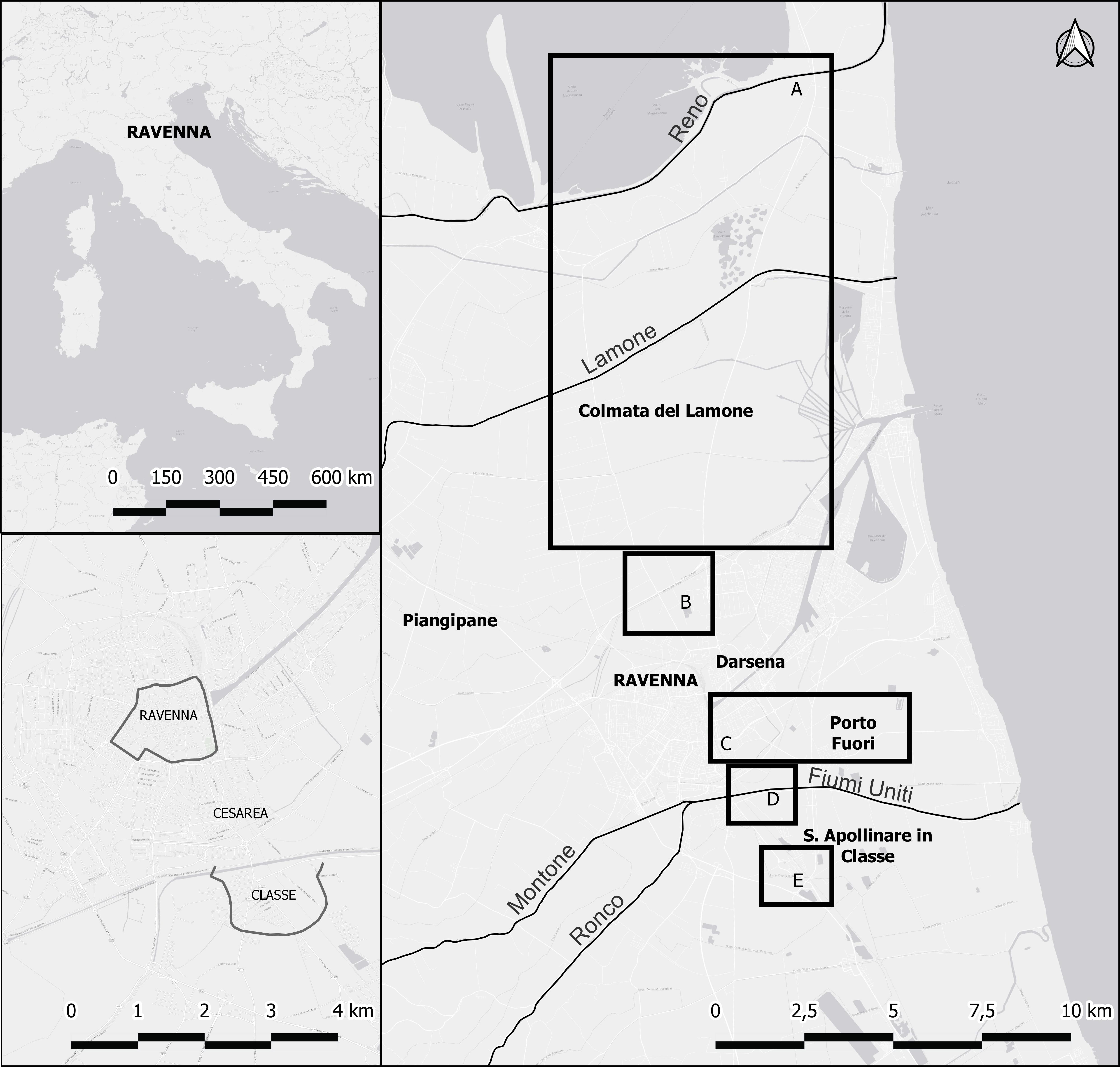 Figure 1. Positioning of Ravenna within the Italian Peninsula (top-left inset), Ravenna-Cesarea-Classe urban system (bottom-left inset), and the location of Ravenna and the five areas discussed in detail with rivers and main towns: A: the area of the Colmata and Po di Primaro river; B: the area of the northern suburb of Ravenna; C: the area of the southern suburb of Ravenna; D: the urban area of Classe; E: the surroundings of Classe (basemap Esri). Author M. Abballe.
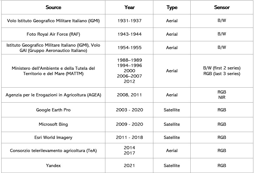 Figure 2. List of aerial and satellite images used for this research. Author M. Abballe.
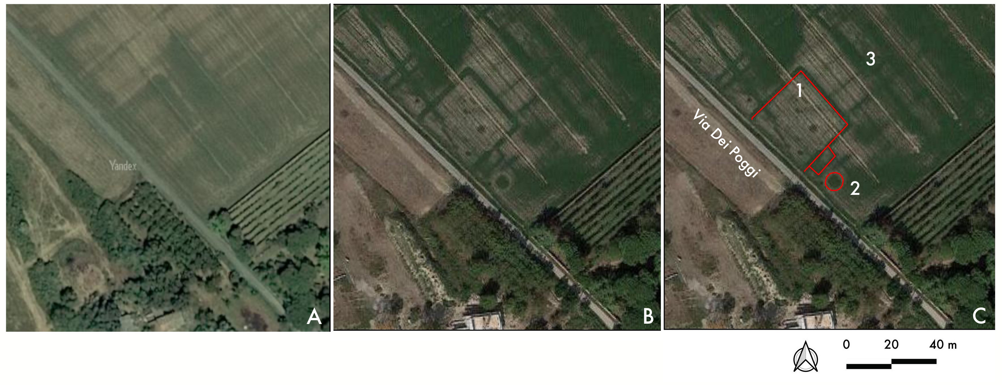 Figure 3. Southern suburb of Ravenna, area north of Fiumi Uniti and near Via dei Poggi: A: site seen on Yandex imagery 2021; B: same site seen on Google Earth 2021; C: possible structural anomalies highlighted: square-shaped structural anomaly (no. 1); circular feature (no. 2); field divisions (no. 3). Author M. Cavalazzi.
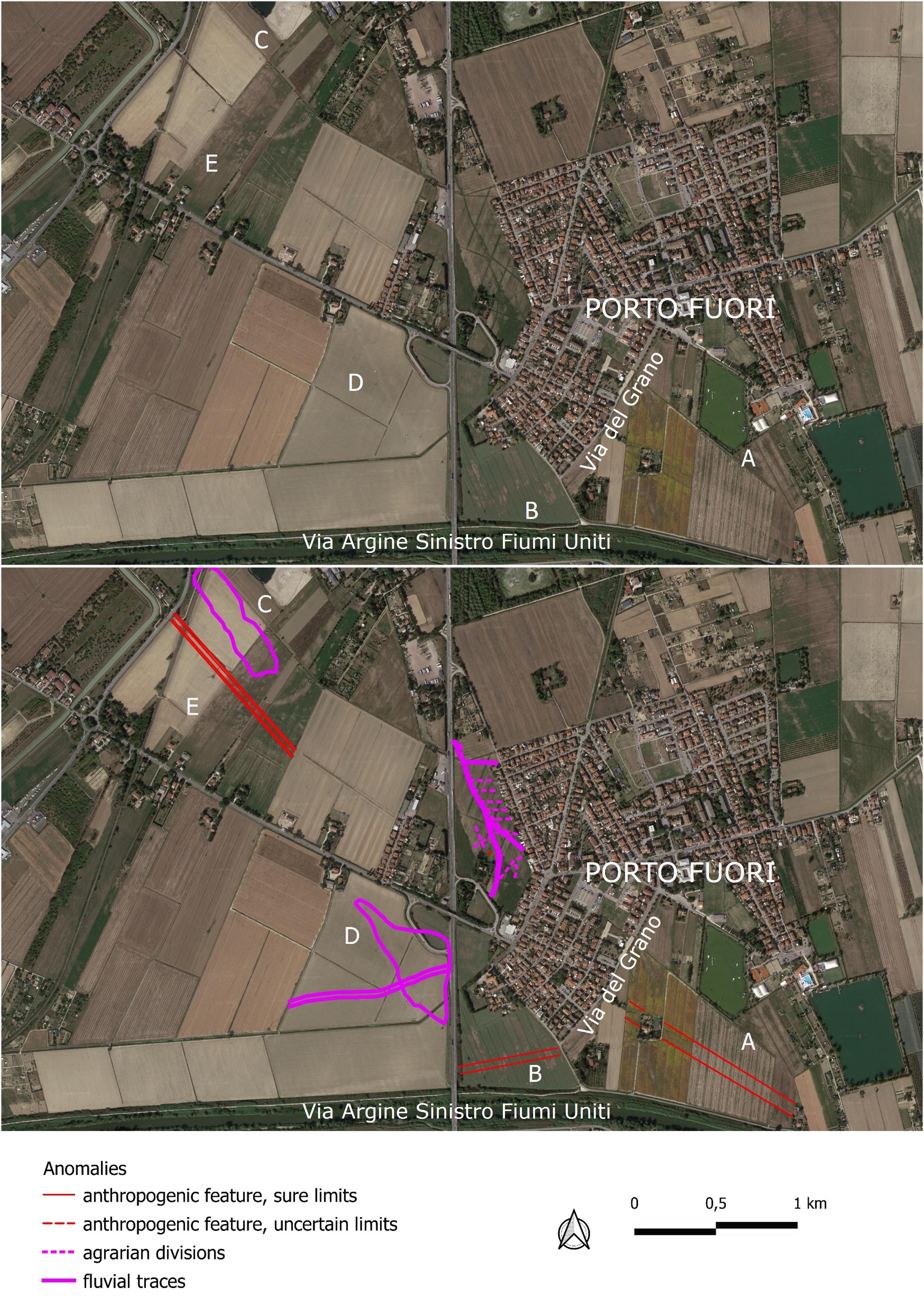 Figure 4. Southern suburb of Ravenna, surroundings of Porto Fuori: A: canal south of Porto Fuori; B: Panfilo canal; C-D: fluvial traces associated with the Badoreno; E: newly mapped canal (Google Earth 9/2021). Author M. Abballe.
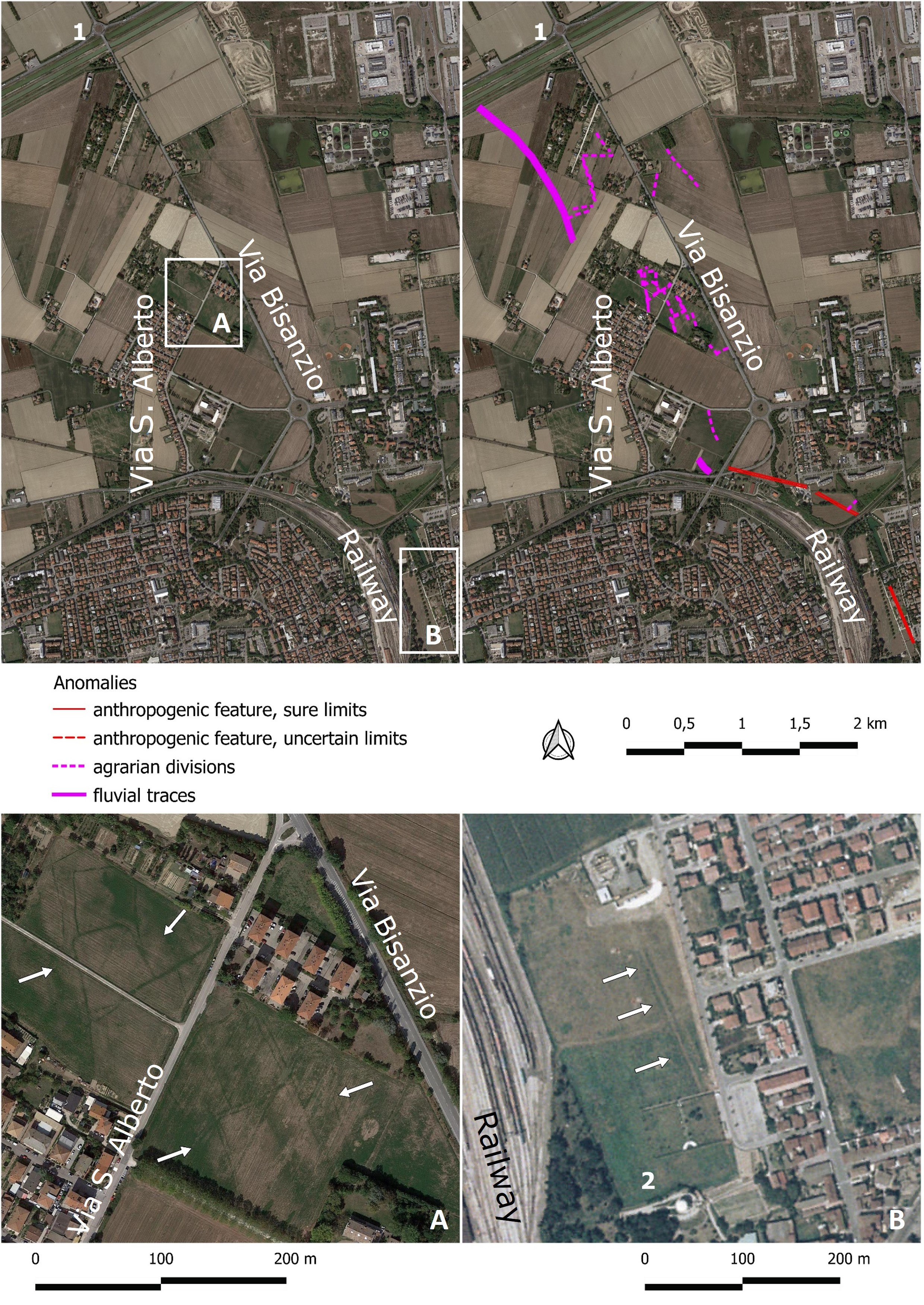 Figure 5. Northern suburb of Ravenna: all newly mapped fluvial and anthropogenic traces (Google Earth 9/2021) with no. 1 indicating the only known archaeological site in the area, dating to the Roman period; A. possible post-Roman field system (Google Earth 9/2021); B: palaeochannel northwest of the Mausoleum of Theodoric, indicated by no. 2 (MATTM 2000). Author M. Abballe.
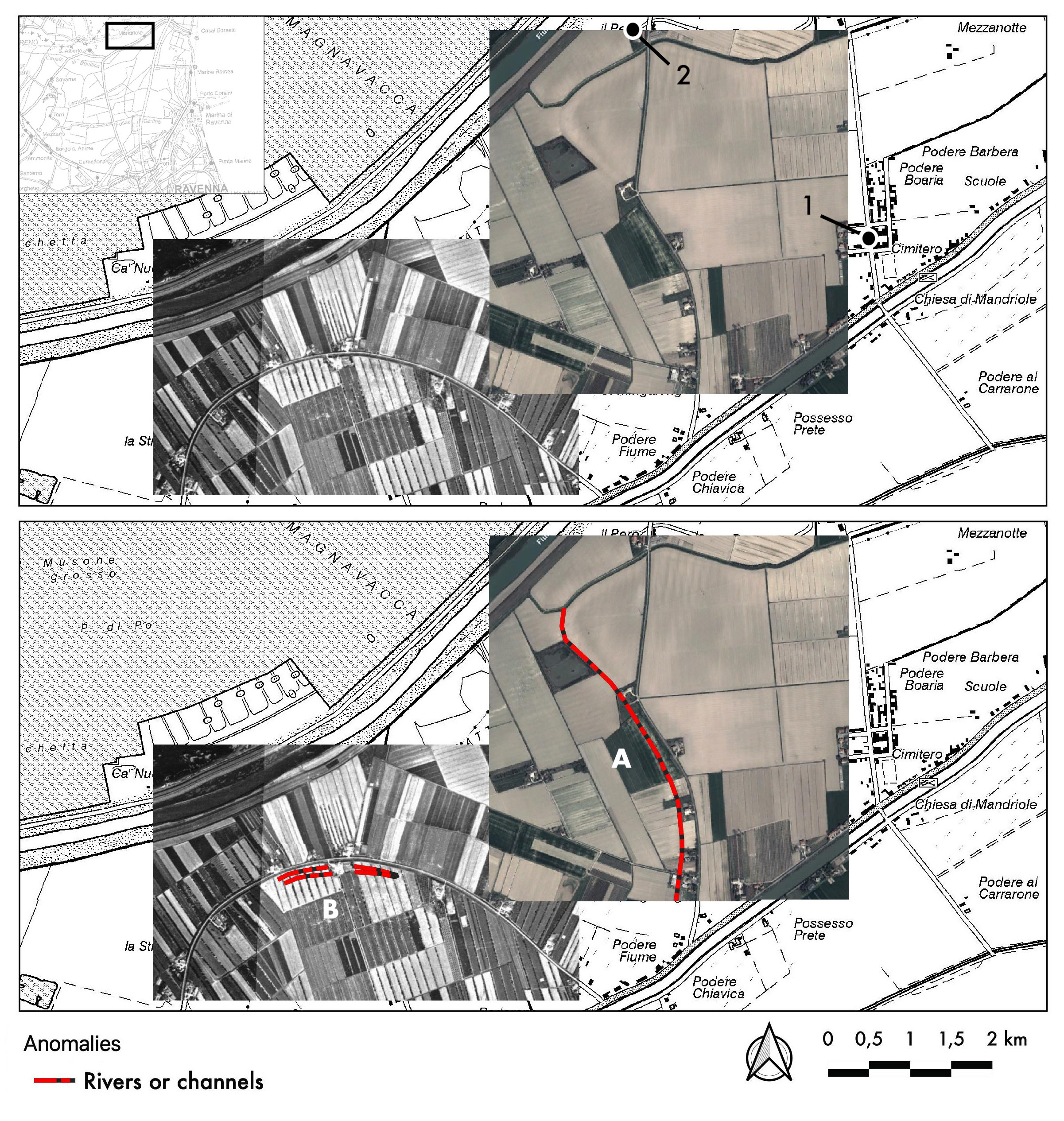 Figure 6. The area of the Po of Primaro near the hamlet of Mandriole (no. 1), seen through Google Earth 3/2011 (letter A) and IGMI-Volo GAI 1954 images (letter B); no. 2 corresponds to the site of the monastery of S. Adalberto in Pereo. Author M. Cavalazzi.
 Figure 7. Area of the Colmata: A: IGMI-Volo GAI 1954 with traces of embankments and channels south of Canale in Destra Reno, while the arrows highlight the Padoreno channel, according to the historical maps; B-C: Volo RAF 1954 over the area of Palazzolo with traces of pinewood; D: IGMI-Volo GAI 1954 with a crevasse splay (no. 1) south of the river Lamone, probably related to the Colmata process and larger fluvial trace (no. 2), near the site of S. Pietro in Armentario (no. 3) – located according to the historical map (Archivio Storico Comunale di Ravenna, CCX, 66) – and the Padoreno canal (no. 4); E: Volo RAF 1954 with the trace of a path/trial (no. 5), the site of Palazzolo (no. 6) and a swale (no. 7); F: IGMI-Volo GAI 1954 with the Padoreno canal (no. 8) and traces of rice paddles (no. 9); G: Google Earth 2021 with agrarian divisions on the dune ridges; H: position of each inset with IGM 1:25.000 basemap and location of S. Romualdo hamlet (no. 10). Author M. Cavalazzi.
 Figure 8. Area of Classe seen on Google Earth 2021 with anomalies described in the text: the harbour-canal of Classe (no. 1), the building north of the Petriana (no. 2), the basilica Petriana (no. 3), and the building with a central octagonal room south of the basilica (no. 4). Author M. Cavalazzi.
 Figure 9. The area of Classe seen on Google Earth 2021 with anomalies in the area of city walls (no. 1), remains of buildings (no. 2), palaeochannels (nos. 3 and 5) and field system (no. 4). Author M. Cavalazzi.
 Figure 10. Area south of Classe with both natural and anthropogenic traces (Esri 2018): A: large swale; B: small quadrangular parcels; C: already known large palaeochannel of a rectified river. Author M. Abballe.
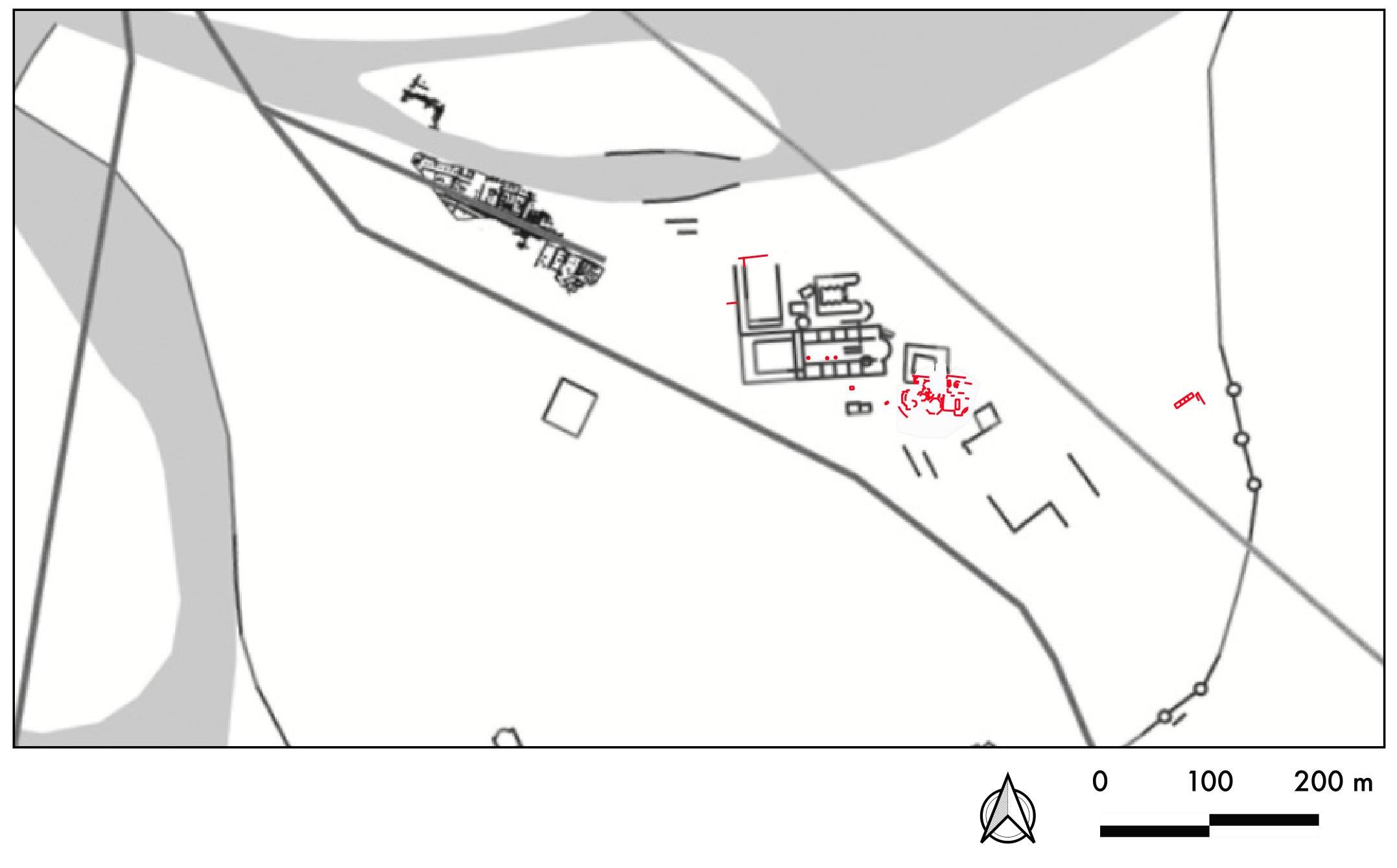 Figure 11. Map of the monuments of Classe with the structures, previously unknown, identified thanks to the aerial and satellite imagery in red. Author M. Cavalazzi.
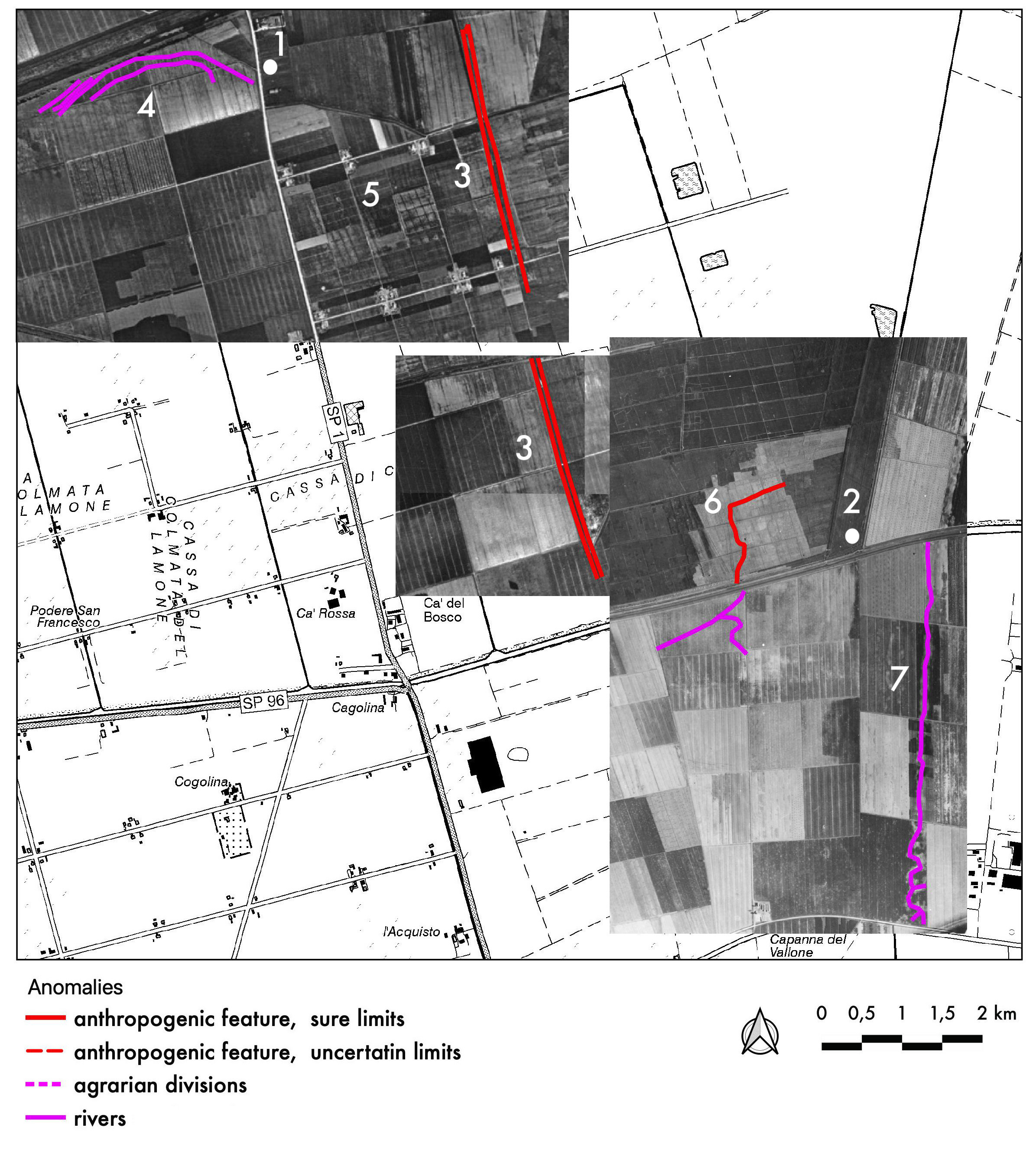 Figure 12. Highlighting of main anomalies near the area of S. Pietro in Armentario (no. 1) and the area of Palazzolo (no. 2): the Padoreno channel (no. 3); fluvial meander (no. 4); rice paddies (no. 5); trail path (no. 6); swale (no. 7). Author M. Cavalazzi.