
Introduction
This contribution aims to be a synthesis of the studies carried out to date on the Roman phase of the city of Terni, enriched by the latest field research accomplished by the author and by the unprecedented use of a GIS platform for data collection and analysis, with the aim of an accurate use of technological tools to support a topographic and urban planning study [1].
In the recent history of the city there have been three periods of great liveliness in the construction sector, which led to new archaeological discoveries. First, between the end of the 19th and the beginning of the 20th century on the occasion of the construction of new roads and the provision of the modern sewer system. Secondly, in the middle of the last century, due to post-war demolition and reconstructions. Although numerically consistent, the findings made in recent years were often poorly documented and can only be positioned in an approximate way.
However, in the last 20 years, because of the construction of new public works and various restoration and reconstruction projects, new data have been brought to light giving further impetus to the archaeological research, thanks above all to better and more efficient documentation.
The city of Terni, the nerve centre and crossing point along the Via Flaminia, represents a very significant example of a continuously inhabited settlement. Its ancient and medieval wall circuit constituted an almost insurmountable limit to the development of the town up to the beginning of the 1900s, when for the first time the expansion outside the circuit itself became necessary, in conjunction with the construction of the steel plants, first and foremost that of the Acciaierie.
This article aims to assess the situation of the city in Roman times, with a particular focus on the Early Imperial age, and tries to offer a unitary reading of the data, also thanks to the support of a new GIS platform created for the occasion.
The geo-morphological context
The city of Terni occupies an elongated alluvial plain about 130 m above sea level with a northeast-southwest orientation, located at the confluence of the Serra stream with the Nera river. The latter originates from the Sibillini Mountains descending towards southwest through the Marmore Falls, until reaching Terni, giving its name to the valley it crosses (Fig. 1).
Its major tributary, the Velino, comes from the Reatini Mountains, and due to the particular composition of its waters (rich in calcium bicarbonate) over time it has deposited carbonate sediments (travertines) that have raised and partially blocked the stretch of the Marmore-Pentima valley and the Rieti plain behind [2].
In the 3rd century BC, the Rieti plain was reclaimed by digging an artificial canal (called “Cava Curiana”, from the name of the consul who took care of it, M. Curio Dentatus), where the waters of the Velino were channeled. From that moment its waters flowed into those of the Nera river, falling down for 165 m and creating the Marmore Falls, where the so-called “sponga” stone [3] (alabaster) is formed, which is also used for the constructions of the Roman city of Interamna.
The valley, very narrow and with a typical “V” profile up to this point, opens into the wide plain of Terni, which extends for about 10 km east-west from Papigno to Narni with a transverse axis of about 3-4 km, surrounded by small uplands and hills.
The basin is crossed from east to west by the Nera river which, due to the slight slope, forms meanders; various streams flow into it, including the Tescino and the Serra, which descend from the heights of Spoleto, and the Aia, coming from the mountains of Configni and Cottanello in Sabina. To the west, the area is closed by the chain of Mount Piglio. To the north, it is dominated by Monte Torre Maggiore (1120 m), the extreme southern offshoot of the Martani Mountains, which rise between the Terni basin, the Spoleto valley and the Tiber valley. Southeast, it is closed by Monte S. Angelo (Fig. 2). The Terni basin therefore represents an obligatory crossing point located on the confluence of important natural routes, such as the Nera, Serra, Velino, Naia valleys etc., which allow the connection with the Sabina, the Faliscan-Capenate countryside, the lower Tiber valley, southern Etruria, the Latium Vetus, and therefore with the Tyrrhenian area on one side. At the same time, it connects the Tudertine countryside, the Volsinii area, the middle and upper valley of the Tiber, the Spoleto area, and the Umbrian-Marche Apennine ridge, from which the Adriatic area can be reached in several points through more or less easy passages [4].
This position, combined with the favourable environmental conditions, facilitated human settlement since Prehistoric times, as evidenced by various findings dating back to the early 1st millennium BC [5].
Toponymy and hydrography of the city
The importance of waterways for the development of the city, and in particular of the Nera-Serra system, also emerges from toponymy. Interamna, Interamnia or Interamnum are the variants used in the sources, meaning “center surrounded by water”. There are also Nartium, Nahartium or Nahars [6], already mentioned by Pliny the Elder (NH. III, 113) as well as in numerous inscriptions, deriving from Nahar, ancient name of the main river of southeastern Umbria, which has the meaning of “sulphurous waters” [7]. The ancient people of the Nahartes (or Naharkus) are already mentioned in the Eugubine Tablets, together with other peoples, as extraneous to the Umbrian nomen [8].
It is no coincidence that the original nucleus of Interamna, the first proto-urban center, the one pertaining to the necropolis of S. Pietro in Campo and the former Alterocca polygraphic, datable to the 7th century BC and about 500 m from the inhabited center, is located near a wade on the Nera, the crossing point of the paths coming from the Serra and Nera valleys (Fig. 3).
However, the ancient hydrographic situation must have been radically different from the current one. The Serra is now a stream with a very limited flow rate, flowing into the Nera in the western part of the city, so that currently the rivers only lap half of the eastern and southern areas of the city [9].
Today the river basin of the Nera river flows into the Conca Ternana, which is thus made up of alluvial plains created by the sedimentary contributions of the main course and its major tributaries: the Velino river, the Aia torrent, the Serra-Tescino torrent, the Bianco-Caldaro ditch.
The central area of the Conca is covered by the recent floods of the Nera and Serra-Tescino, while the most ancient continental fluvial-lacustrine deposits emerge around it. This is also testified by the presence of several terraces, among which one of the most evident is the one located south of Terni, in locality “Le Grazie”.
Nevertheless, the natural evolution of the Terni basin suffered the effects of anthropic intervention with the opening of the aforementioned Curiana quarry, which caused a significant change in the hydrographic situation of the area. In 271 BC, on the occasion of a reclamation project that involved the Conca Reatina, a cleft was made in the travertine of the Marmore, which had the purpose of varying the course of the Velino river, so that, instead of flowing into the plain of Rieti, diverted to that of Terni.
The average flow of the Nera river, currently estimated at around 75-80 m3/s on an annual basis and with a fairly regular regime, owes a considerable part of this volume to the Velino. The cutting of the Marmore ensured that the waters of the Velino increased the flow of the Nera river with the consequent beginning of a phase of greater erosion of the riverbed. The greater erosive force acquired by the latter could have, over time, lowered the altitudes southeast of Terni, in the area where the river enters the Conca, causing the capture of the Serra Tescino stream and the consequent shift to the northeast of its confluence with the Nera [10].
The city is currently located west of the confluence of the two rivers and for this reason it is less subject to the floods which, instead, the inhabitants of Interamna had to face. This ancient centre was located at the confluence of the Nera with the Serra-Tescino, which in Roman times probably run upstream of the city and then descend towards the southwest downstream of the amphitheater area (Fig. 4, Fig. 5).
The almost rectilinear deviation of the Serra-Tescino may suggest an anthropic intervention (or, at least, favoured by men) which, afflicted by continuous floods, attempted to solve the problem in this way [11].
Brief historical overview
The first traces of settlements in the area of the future center of Interamna Nahars date back to the phase between the Eneolithic and the Bronze Age, a period to which the village of huts identified in the area of Acciaierie, below the levels of the subsequent necropolis, is attributed. It is during the early Iron Age that archaeological evidences document a continuity of frequentation in the area, now populated by a series of settlements located both within the future city (Clai district) and in the immediate vicinity (Pentima, Rocca S . Angelo, Maratta Bassa) [12].
An inscription from the Tiberian age (CIL XI, 4170), dated 32 AD and found at the entrance to the amphitheater, places the foundation of the city 704 years earlier, therefore in 672 BC [13]. The archaeological data, however, seems to confirm the presence of a settlement already in the 7th century BC. In fact, the necropolis of the Acciaierie refers to the first period of attendance, extending north of Terni over a vast area between the slopes of the Pentima hill and the locality of S. Pietro in Campo (near the railway station) and frequented from the 10th to the 4<sup">th century BC. The final phase of attendance of the necropolis coincides with the beginning of the Roman conquest of Umbria. The Umbrian people of the Nahartes, “the inhabitants of the Nera valley”, were probably annexed to the Roman territory around the middle of the 3rd century BC, certainly after the conquest in 299 BC of Nequinum, renamed Narnia in that occasion, and before the deduction of the colony of Spoletium in 241 BC.
The district became a viritane settlement and the locals were granted the status of civitas sine suffragio. It was probably only towards the end of the Republican age that the inhabitants were recognized as optimo iure citizenship. The establishment of a praefectura probably dates to this most ancient phase, from which the centre of Interamna will evolve. During the same period of time, the reclamation of the lacus Velinus (275-274 BC) with the diversion of its waters into the Black River through the Marmore Falls, but also the opening of the Via Curia (272 BC) connecting Interamna to Reate, was accomplished by the consul M. Curio Dentatus. The Romanization of the area was established with the construction of the Via Flaminia around 220 BC. Therefore, the construction of the walls and the definition of the road layout were completed. The praefectura of Interamna was transformed in 90 BC in a municipium governed by a group of quattuorviri and the inhabitants were enrolled in the Clustumina tribe [14]. In the 1st century BC, Interamna was probably affected by the clashes between Mario and Silla, siding with the former and suffering repercussions from the latter during the period of the dictatorship (Flor. II, 9). During the last years of the Republic, the center is often remembered for some disputes with Reate regarding the Curiana quarry, which, while on the one hand ensured the drainage of the Rieti plain, on the other exposed the Terni basin to flooding. Among the most famous of these judicial controversies is that of 54 BC. narrated by Varro (Varr., r.r. III, 2, 3) and by Cicero (Cic., ad Att., IV, 15, 5).
Starting from the 1st century BC, there was a period of prosperity that culminated in the following century, when the urban layout was definitively redesigned, together with the construction of the water and sewerage networks. Between the end of the 1st century BC and the first part of the 1st century AD, the theater, the amphitheater and at least two large thermal complexes, among other buildings, were built [15]. Also during the Augustan age, the municipium was included in the Regio VI (called Umbria or Umbria et Ager Gallicus).
Between the end of the 2nd and the beginning of the 3rd century AD, the presence of at least two curatores civitatis, imperial officials sent to put local finances in order, also allows to place Interamna in the climate of general economic decline and limitation of autonomy that affected most of the cities of the empire. The lack of inscriptions relating to public works or municipal magistrates may suggest a managerial inability of the local ruling class. Nevertheless, the solicitude with which the emperor tried to remedy this situation and the high rank of the two curatores testify to the persistent importance of the city, essentially linked to its proximity to Rome, its strategic position and the richness of its territory [16].
Between the 3rd and 4th century AD, when Diocletian created the new administrative order dividing Italy into provinces dependent on a corrector, Interamna Nahars, with all the Cisappennine already included in Regio VI, became part of the province of Tuscia et Umbria, which in the mid-5th century AD would become Tuscia.
For the Late-Antique period, despite the silence of the sources, it is likely that the city suffered devastation both by the Visigoths of Alaric in 408-410 AD and during the Greek-Gothic wars, at least to judge the events that affected the neighbouring centres of Narnia and Spoletium, given its strategic position and the location along the Via Flaminia.
Starting from the end of the 6th century AD, Interamna was in a phase of full decline and became part of the Longobard Duchy of Spoleto. In 598 AD, the dioceses was entrusted to the bishop of Narni, as it is documented as early as the end of the 4th century AD [17].
Viability and organization of the inland
It is only from the beginning of the 3rd century BC that it is possible to speak of a “city” in the sense of a regulated and organically equipped settlement with defined urban shape [18]. As for many other Italic centers, the so-called Romanization period corresponds to a decisive urban layout, at least in its essential features, such as margins, main roads, definition of the forensic area, and so on.
Although it is quite complex to try to outline the course of the walls in some parts of the city, such as along the eastern side, it is still possible to reconstruct the space occupied by the urban area with some precision. The dimensions of the initial nucleus were 1000 x 500 m (respectively with east-west/north-south orientation), which in any case had to undergo several extensions, perhaps already in Roman times. The length of the wall circuit was to exceed 2.5 km, delimiting a vaguely pentagonal area of about 35 hectares (Fig. 6). The city had four entrances, each marked by the terminal point of a very important road axis: on the north and south sides the Flaminia [19] (between Narnia and Spoletum), on the west side the road coming from Tuder-Carsulae, and on the east the via Curia coming from Reate (Fig. 7, Fig. 8).
The main urban road axis crossed the city with a south/southwest-north/northeast direction. The Via Flaminia came from Rome and entered [20] the city through the “Roman gate”, whose wall stretches are still visible in Piazza Briccialdi [21]. An evidence for the location of the entrance is preserved in the name of the church of S. Nicolò, known among Modern age sources as S. Nicolò «fra le porte» [“between the gates”] or «infra portas”. In the documents of the 13th century, it is defined as Sancti Nicolai foris portam or even foris portam antiquam [22].
The first urban stretch of the road coincided with the current Via Roma (below which an ancient pavement over 100m wide was found in the 1940s). The second stretch most likely coincided with today’s Corso Vecchio (sections of paving were found in Piazza San Pietro and in Piazza Corona). Its course, due to the existence of an older route, was not exactly straight, especially in correspondence with Via dell’Ospedale and the former Palazzo Sanità. Today’s Via Cavour - Via Garibaldi was instead the other main urban road axis. Sections of stone-paved roads have been found here as well [23]. The Forum area was located at the intersection of these two roads, corresponding to the current Piazza della Repubblica - Piazza Solferino. This preserved the role of gravitational center of the city for a long time, at least until the 13th century, with the construction of Palazzo del Popolo.
It is possible to notice an imperfect orthogonality between the two main road axes. The cause of this is to be traced back to the pre-Roman road layout which included two routes later reused by the subsequent planning (Fig. 9). The analysis of the Duomo district allows us to trace a planning grid based on a theoretical module of 2 square actus (240x240 Roman feet, approximately 71x71m). The definitive arrangement of the urban layout involved the construction of numerous infrastructures starting from the 1st century BC.
The city can be considered divided into four quadrants:
- the southwest sector was considered a sort of monumental district. In fact, the theater [24] was built here (between Via del Teatro Romano, Via XI febbraio, Via Tre Colonne and Via Aminale), as well as the amphitheater [25], but also several thermal baths, two of which were very likely of large dimensions [26] (Fig. 10);
- the southeastern and northwestern sectors were instead used for private buildings, whose archaeological evidence are visible in the remains of the domus found under the church of S. Salvatore [27] and under Palazzo Pierfelici [28].
- the northeastern sector, with a fairly irregular layout, gravitated around Piazza Clai, which is the area that in all probability had constituted the first settlement of the city since the arrival of the first Nahartes. Sections of pipelines and sewers have been found in this area, which testify to a developed water and sewage system connected to the roads and integrated by cisterns, basins and wells [29].
Many of the remaining archaeological findings date back to the Early Imperial age, a period in which the urban structure appears more clearly recognisable.
After the Roman conquest, the organization of the extra-urban area also underwent a rationalisation. The high ground settlements of pre-Roman origin were gradually abandoned to the advantage of sites closer to the main roads and to the areas most suitable for an advanced agricultural development [30].
With the end of the Social War and the acquisition of the status of municipium, the urban growth became stronger, reaching its peak during the Augustan age. Regular planning dates back to this period, traceable in the Duomo district with the adoption of a scheme based on the double actus, and the location within the walls and in the same sector of the buildings for plays and recreational purposes, urban topos typical of the Augustan period [31]. The Roman layout will also be preserved in Μedieval times, with continuity of frequentation of the various routes. This is especially true for the city center, while the suburban areas were destined for other uses, eg. gardens, and do not always retain the original orthogonality (Fig. 11).
GIS platform and methodological issues
The outlined framework was also made possible thanks to the creation, as part of a research project, of a GIS platform that supports a database alongside the archaeological map already drawn up during the ‘90s, suitably digitized, georeferenced, modified and updated with information on the latest findings (Fig. 12).
The reasons for choosing the GIS-based platform reside in the advantages offered by this tool, first of all the possibility to associate alphanumeric information with spatial and geometric data. In this way it was possible to integrate a database containing all the useful information for an urban planning study and which can be used with profit even by those who will not read this work. Basically, the first step was creating the GIS environment, populating it, inserting all the available data, the result of archival and field research work, and then moving on to the filing of the evidences and the compilation of the thesis work, using computer science technology as a support tool.
We have chosen to use QGIS because in addition to being an open source system, it also offers significant advantages, such as the opportunity to use a wide range of plugins that are constantly added and updated by a development team composed by volunteer programmers. It offers similar, if not better, possibilities than proprietary software (eg. ArcGIS) with the advantage of always being free from copyright and restrictive user licenses, and therefore implementation costs.
The data was entered in tabular form. A mask was created only at the end in order to have an interface that was as user friendly as possible, simple and intuitive even for those who are not accustomed to the use of computer systems and which includes, in addition to data tables, even raster images (photos, drawings and plans).
In particular, this data entry operation required some time, necessary for a research and careful evaluation of the documentary material [32], a comparison between the information collected and surveys on the field to assess its reliability and to produce further documentation, especially photographic one, to be added.
Even if the focus of this study is the Roman age during the Imperial period, the project has been enriched with the most important evidence of the Protohistoric, Late Antique and sometimes Medieval age, above all based on the continuity of use of certain contexts or monuments.
A completely new subject is the altimetric one, which has never analyzed until this moment for the whole city of Terni in a complete and systematic way, but only for single excavation areas and rather restricted contexts. Within the GIS platform the topic was addressed using first the Regional Technical Map (CTR), freely downloadable from the Geoportale of the Umbria Region [33], which offers a 1: 5000 scale cartography and is the only officially recognized tool on which the heights rely on. In fact, the map shows several listed points scattered throughout the city center. The problem with this cartography, however, in addition to the obviously too small scale for an urban context (with consequent difficulty in establishing the exact point to which the altitude points refer) also lies in the small number of the elevation points themselves. An alternative and more effective method was therefore sought, finding it in the DTM and DSM, digital terrain models that map the Earth’s surface by presenting elevation points at regular distances. In various online portals a completely free and easily downloadable cartography is available, but at very small resolutions (eg. 20m [34] or 90m [35]). If this definition may be sufficient for the analysis of a relatively large portion of the territory, it certainly would not have been reliable in an urban context such as the one in question.
For this reason, the choice fell on the cartography produced by LiDAR technology [36], thanks to which in 2008 the whole national territory was mapped with systems of maximum precision and much higher ground resolution (1 m) [37].
Before proceeding, however, a comparison was made between the elevation of the DTM produced with LiDAR and the elevation of the CTR in order to check their differences and their reliability. Therefore, for each elevation point of the CTR, the relative altitude in the DTM was checked. The difference in these measurements is always within 10-25 cm, an acceptable error especially since it occurs uniformly throughout the area under examination (Fig. 13) [38].
Once the data referring to the current situation of the city center were inserted in the platform, the DTM referring to the ancient period was created trying to recover the heights of the Roman age floors.
For this reason, a vector of points was created, containing all the relative heights collected through the bibliographic analysis, the excavation reports, the plans and the perspective drawings available. The problem that has arisen in this phase is related to the date of survey and the accuracy of the altitude report. Inaccurate information or information with a too wide range of heights were not taken into account and were excluded from the calculation. On the other hand, there were heights that could be easily positioned in space, or whose location was easily traceable, even though there were surveyed in the early years or in the middle of the last century. For example, several finds of paving stones no longer visible today fall into this category. Since they referred to relative measurements, it was impossible to establish with certainty what the measurement reference plane was, above all when considering the strong changes in the urban landscape, especially as a result of the massive bombings of the Second World War. Therefore, all the heights were entered into the platform and it was analyzed which information most agreed with the most recent news relating to the last 30-40 years. Most of the time the feedback was positive, while some other testimonies, those reported in a less precise way, seemed unreliable. As a consequence, it was decided to calculate the ancient DTM preferring the precision and reliability of the information over the quantity of points [39]. Nevertheless, the amount of information was more than sufficient to create a reliable model (Fig. 14, Fig. 15, Fig. 16).
It is important to point out that this model can be reworked and improved in the future if new information on heights is added following new urban surveys, using the same methodology that has proven to be valid and functional.
In addition to a greater amount of data, it would have been desirable to have a more uniform spatial diffusion of the listed points within the historic center, since the algorithm works better with points that tend to be equidistant. This was not possible because, while the greatest number of evidence is concentrated in the southern area, for the northern part of the city the information available is very scarce. This is due not only to the numerous road reconstruction works that took place in the first half of the last century, which have often erased the Roman remains, but also to the bombings that hit this area the most, definitively disturbing its stratigraphy.
Thanks to the altimetric bases mentioned above, it was therefore possible to calculate the absolute height for each point, after which the Roman altimetric model was created and overlapped on the modern one by means of an algorithm implemented in the GIS system, in order to appreciate the variations and changes that have taken place over the centuries.
Considerations on the altitude
The elevation situation of the current city is markedly variable, going from 124 m amsl in the area where the ancient city walls ran, climbing up to about 130 m amsl at the current Piazza della Repubblica - S. Giovanni Decollato (the ancient Forum area), descending again until returning at 124 m amsl to the opposite side, almost symmetrically. Even along the same route, it is possible in some cases to notice significant differences in altitude between the beginning and the end of it. By observing today’s altimetry, it is possible to see how the city develops beyond a lower area of about 2 m, then a moat that can be traced immediately behind the walls: this is almost certainly the area where the water course ran, which contributed to giving the ancient city the toponym Interamna (Fig. 18). One hypothesis is that the original river bed was later reduced to a defensive moat for the walls.
The Roman finds within the city, with rare exceptions, are located between 30 cm and 3 m below the level of the current floor.
From the overlap of the two DTMs, it is possible to see how the difference in height of the old one was very low compared to the current one (the absolute altitudes range roughly from 124 to just over 126 m amsl). The current profile retraces the ancient altitudes near the perimeter area, and it follows the ancient profile, highlighting the existing differences in altitude (Fig. 17). The only exception to the regularisation of the heights according to a well-defined profile appears to be the structure in Piazza S. Giovanni Decollato (-6 m below the current walking surface), whose interpretation is still rather obscure (however, it is almost certainly a public structure [40]) which in all probability was already under the walking floor in ancient times (Fig. 19, Fig. 20) [41].
However, the uniformity of the Roman city is reiterated, which undoubtedly had to suffer from the morphological situation of the area but still managed to maintain a certain regularity that today no longer appears visible. The area of the Forum, slightly higher than the marginal areas, could also symbolically rise to the control center of city life, while the peripheral areas (such as the area of the southwestern amphitheater or that of the thermal baths near the east gate) rose a little below, with a particular attention to a space division and heights that does not seem casual.
Such analysis, in addition to being useful from the point of view of research, as it is very suitable for better understanding the urban planning of the Roman city, can also be used as a valuable tool for the more correct management and enhancement of the archaeological potential, for example by public institutions that have to plan a sustainable management of their territory on a daily basis. It is therefore hoped that this study will be resumed and implemented in the future, following the extension of archaeological or archival researches.
 Fig. 1. View of the Marmore Falls over Valnerina
 Fig. 2. Satellite image of the ares highlighting the mountain and hill ranges
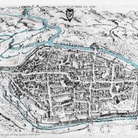 Fig. 3. View of the town of Terni on a drawing by Domizio Gubernari. In top the confluence of the Serra into the Nera (reworked version of Angeloni 1646).
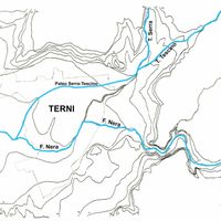 Fig. 4. Ancient hydrographic layout (reworked version of Fazzini, Maffei 2006).
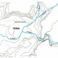 Fig. 5. Current hydrographic layout (reworked version of Fazzini, Maffei 2006).
 Fig. 6. Hypothetical trace of the defensive walls in Roman period. 1) Sant’Angelo gate; 2) San Giovanni gate; 3) Sesto gate; 4) Roman gate.
 Fig. 7. Extraurban road network from Rome. In the red square the two branches of uia Flaminia (reworked version of Coarelli, Sisani 2008).
 Fig. 8. Topographical context of Interamna: 1) Via Flaminia; 2) Road to Tuder- Carsulae; 3) Via Curia to Reatae.
 Fig. 9. First and second order road network of Interamna Nahars.
 Fig. 10. Urbanistic layout of the south-western part of the town, where it is possible to note that most of modern building blocks has maintained the original Roman orthogonal shape.
 Fig. 11. Anonymous, view of the city od Terni (Barb. Lat. 9901, f.96, second half of 17th Century). Reworked version; the defensive walls after the most recent expansion of the 15th Century, the rivers and some channels have been highlighted. The red line marks the hypothetical Roman perimeter.
 Fig. 12. Screenshot of the QGIS project showing the base cartography and the numerated archaeological evidences.
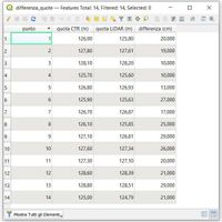 Fig. 13. Diference of elevation between CTR and LiDAR.
 Fig. 14. Elevation points used for the creation of the DTM referred to the Roman period.
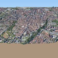 Fig. 15. Dynamic 3D model of the city, based on the DTM data.
 Fig. 16. Comparison of elevations in the current DTM and in the one referred to the Roman period, obtained through a raster analysis
 Fig. 17. Positioning of the altimetric profiles.
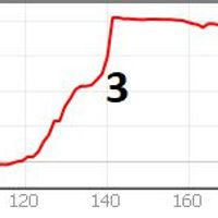 Fig. 18. Current altimetric profile of the western area. In the x-axis the elevations expressed in meters: 1) extraurban area; 2) ditch where the riverbed of an ancient stream can be recognized; 3) defensive walls; 4) urban area.
 Fig. 19. South to north altimetric profile of the town along the main road. In red the current profile, in blue the Roman one.
 Fig. 20. South to north altimetric profile, in the center of which is located the square of S. Giovanni Decollato. In red the current profile, in blue the Roman one.


Reference list
- Andreani, C. 1997. “Il municipio romano.”, in Interamna Nahartium: materiali per il Museo Archeologico di Terni, edited by V. Pirro. Arrone: Thyrus
- Andreani, C. and M. Fora. 2002. “Regio VI. Umbria: Interamna Nahars.” in Supplementa Italica, Nuova serie, 19. Roma: Quasar
- Angelelli, C. and S. Zampolini Faustini. 2005. “Frammenti musivi inediti da Terni (Interamna Nahars).”, in Atti del X Colloquio dell’Associazione Italiana per lo Studio e la Conservazione del Mosaico (AISCOM), Lecce, 18-21 febbraio 2004, edited by C. Angelelli. Tivoli: Scripta Manent
- ———. 2006. “L’anfiteatro romano: il progetto di recupero e l’indagine archeologica.”, in Terni – Interamna Nahars. Nascita e sviluppo di una città alla luce delle più recenti scoperte archeologiche, edited by C. Angelelli and L. Bonomi Ponzi. Roma: Quasar
- Angeloni, F. 1646. Historia di Terni descritta da Francesco Angeloni, et dedicata all’eminentissimo, e reuerendissimo signor cardinale Giulio Mazarini. Roma: nella stamperia di Andrea Fei
- Bonomi Ponzi, L., L. Ermini Pani, and C. Giontella. 1995. L’Umbria meridionale dalla protostoria all’alto Medioevo. Terni: Provincia di Terni
- Bonomi Ponzi, L. 2006. “Introduzione.”, in Terni – Interamna Nahars. Nascita e sviluppo di una città alla luce delle più recenti scoperte archeologiche, edited by C. Angelelli and L. Bonomi Ponzi. Roma: Quasar
- Ciotti, U. 1974. “I resti romani dell’area di S. Salvatore.”, in S. Salvatore e altri monumenti restaurati dalla Cassa di Risparmio di Terni, edited by R. Pardi and U. Ciotti. Terni: Cassa di Risparmio di Terni
- De Angelis, M. C. 2015. “La necropoli delle Acciaierie di Terni-cenni storici e ipotesi di interpretazione.” in La delimitazione dello spazio funerario in Italia dalla Protostoria all’età arcaica. Recinti, circoli, tumuli. Atti del XXII Convegno Internazionale di Studi sulla Storia e l’archeologia dell’Etruria (2014), edited by G. M. Della Fina. Roma: Quasar
- Fazzini, P. and M. Maffei. 2006. “Appunti di geologia e geomorfologia della Conca ternana.” in Terni – Interamna Nahars. Nascita e sviluppo di una città alla luce delle più recenti scoperte archeologiche, edited by C. Angelelli and L. Bonomi Ponzi. Roma: Quasar
- Fontaine, P. 1990. Cités et enceintes de l’Ombrie antique. Bruxelles-Roma: Institut historique belge de Rome
- Gaggiotti, M., D. Manconi, L. Mercando, and M. Verzar. 1993. Umbria, Marche, Roma-Bari: Laterza
- Giani, S. and S. Giani. 1998. “La situazione pre progettuale.”, in Palazzo Gazzoli a Terni: storia di un recupero. Terni: Istituto per l’edilizia residenziale pubblica
- Giorgi, F. 2006. “Lo scavo di piazza S. Giovanni Decollato.”, in Terni – Interamna Nahars. Nascita e sviluppo di una città alla luce delle più recenti scoperte archeologiche, edited by C. Angelelli and L. Bonomi Ponzi. Roma: Quasar
- Giuliani, C. F. 1974. “Lucca, il Teatro e l’Anfiteatro.”, in Atti del Convegno Internazionale sui metodi di studio della città antica: Garniano del Garda, 8-11 Maggio 1973. Milano: Cisalpino-Goliardica
- Grassini, P. 1957. “Le sottostrutture romane alla luce di recenti scavi della chiesa di S. Salvatore in Terni.”, in Atti del V Convegno Nazionale di Storia dell’Architettura: Perugia, 23 Settembre 1948. Firenze: R. Noccioli
- Gregori, G. L. 1989. Epigrafia anfiteatrale dell’occidente romano. Roma: Quasar
- Johnson, K.M. and W.B. Ouimet. 2014. “Rediscovering the lost archaeological landscape of southern New England using airborne light detection and ranging (LiDAR).”, in Journal of Archaeological Science, vol.43. DOI: https://doi.org/10.1016/j.jas.2013.12.004
- Leonelli, V. 2003. La necropoli della I età del ferro delle acciaierie a Terni. Contributi per un’edizione critica. Firenze: All’Insegna del Giglio
- Perissinotto, C. and S. Zampolini Faustini. 1993. “Dall’età romana al Medioevo.”, in Storia illustrata delle città dell’Umbria. Terni, vol. I, edited by M. Giorgini. Milano: E. Sellino.
- Prosdocimi, L.A. 1978. “L’Umbro.”, in Lingue e dialetti dell’Italia antica. Popoli e civiltà dell’Italia antica, VI. Roma: Biblioteca di Storia Patria
- ———. 2001. “Etnici e ‘nomen’ nelle Tavole Iguvine.”, in Gli Umbri del Tevere. Atti dell’VIII Convegno Internazionale di Studi sulla Storia e l’Archeologia dell’Etruria. (Annali della Fondazione per il Museo ‘Claudio Faina’”, edited by G. M. Della Fina. Roma: Quasar
- Ranucci, C. 1997. “Interamna Nahars nella tarda antichità: l’avvento del Cristianesimo.”, in Interamna Nahartium: materiali per il Museo Archeologico di Terni, edited by V. Pirro. Arrone: Thyrus
- Silvestri, L. 1977. Collezione di memorie storiche tratte dai protocolli delle antiche Riformanze della città di Terni dal 1387 al 1816 relative al suo stato politico morale civile industriale ed ai suoi rapporti colle altre città e luoghi convicini non che alla storia contemporanea. Terni: Thyrus
- Sisani, S. 2006. Umbria, Marche. Roma-Bari: Laterza
- ———. 2008. “Interamna Nahars in età romana.”, in Museo Comunale di Terni. Raccolta archeologica Sezione romana. Catalogo regionale dei beni culturali dell’Umbria, edited by F. Coarelli and S. Sisani. Perugia: Editori Umbri Associati
- Sommella, P. 1988. Italia Antica. L’urbanistica romana. Roma: Jouvence
- Terni 1980. L’Umbria: manuali per il territorio. Terni. Roma: Edindustria
- Zampolini Faustini, S. 1993. “La città romana.”, in Storia illustrata delle città dell’Umbria. Terni, vol. I, edited by M. Giorgini. Milano: E. Sellino
- ———. 2006. “Topografia ed urbanistica di Interamna Nahars.”, in Terni – Interamna Nahars. Nascita e sviluppo di una città alla luce delle più recenti scoperte archeologiche, edited by C. Angelelli and L. Bonomi Ponzi. Roma: Quasar
Notes
1. Special thanks to Alessandro Jaia, who allowed this research as supervisor in the occasion of my master’s thesis at Sapienza University of Rome and to Julian Bogdani, the co-advisor, who helped me by giving very helpful advices both in the research phase and in the writing of this article.
2. Leonelli 2003, 24-25.
3. It is a lithoid travertine characterized by a spongy consistency and large vacuolarities; hence the ancient term sponga, from the Latin spongia, meaning “sponge”. Lightweight and easy to work with as soon as it is extracted, the “sponga” stone hardens and acquires compactness with air exposure. For this reason it has been widely used since ancient times in the Terni area, where it has found widespread use as a building material.
4. Bonomi Ponzi 2006, 1.
5. Cf. Bonomi Ponzi, Ermini Pani, Giontella 1995, Leonelli 2003, but also De Angelis 2015.
6. Prosdocimi 2001, 62-77.
7. The ethnic origin of the Naharci, deriving from the name Nahar, or Nera, is found for example in the names S. Anatolia di Narco, Narni and in all probability in that of the Naia stream (from a presumable Naria). See Prosdocimi 2001, 70.
8. Probably they belonged to a mixed Umbrian-Sabine lineage, as the extension of the ethnic group would seem to imply, also in the area of internal Sabina (Prosdocimi 1978, 585-787).
9. The studies conducted at the end of the last century by Paolo Fazzini and Marisa Maffei have finally shed light on a question which had never been fully resolved until then (Fazzini, Maffei 2006, 57-62).
10. Fazzini, Maffei 2006, 58.
11. Information about a work of such great importance as the displacement of the course of a river has not yet been found in medieval documents. It would therefore not be excluded the hypothesis that the path of the Serra was the same as the current one, while to the west of the city another watercourse flowed, a torrent that has lost its flow over the centuries, or a channel of a certain relevance.
12. Sisani 2008, 29-30.
13. Andreani, Fora 2002, 48-49 but also Gregori 1989, 17.
14. Zampolini Faustini 1993, 60.
15. Giani 1998, 67-70, Angelelli, Zampolini Faustini 2005, 847 but also Zampolini Faustini 2006, 154-155.
16. Andreani 1997, 140.
17. Sisani 2008, 46.
18. Starting with the construction of the city walls, whose first plant in opus quadratum is attributable to this period (Sisani 2006, 196-197).
19. The road leading from Rome to Terni was the so-called Flaminia nova, i.e. a deviation from the original road, which detached from the route near Narni, passed through Interamna, Spoletium, Fulginuim and at Forum Flaminii rejoined the route of the Flaminia vetus.
20. According to the most ancient reconstructions, the Via Flaminia flanked the city to the east without however crossing it (Fontaine 1990, 126). More recent studies, on the other hand, argue that the main urban axis was made up of the street itself. Consequently, the current via Roma and Corso Vecchio would constitute the section crossing the city (see Ranucci 1997, 174, but also Perissinotto, Zampolini Faustini 1993, 70).
21. It is interesting to note how this area of the city is defined by oral sources as the “Roman gate”, while the area between the square and the river, although incorporated in the expansion of the walls built in the Middle Ages to defend the bridge, is still referred to today as “outside the Roman gate”.
22. Zampolini Faustini 2006, 148.
23. Silvestri 1977, 498.
24. See for example Terni 1980, 94, Gaggiotti et alii 1993, 43-44.
25. Among many contributions, see Giuliani 1974, 287-293, Silvestri 1977, 73-75, Angelelli, Zampolini Faustini 2006, 205-225.
26. Angelelli, Zampolini Faustini 2005, 847-848, Zampolini Faustini 2006, 154-155.
27. Grassini 1957, 475-479, Ciotti 1974, 71-101.
28. Angelelli, Zampolini Faustini 2005, 849, Bonomi Ponzi 2006, 18.
29. Zampolini Faustini 2006, 156.
30. Cf. Bonomi Ponzi 2006, 20.
31. Sommella 1988, 153-159.
32. In addition to the published material, consultation of the archival documentation was also fruitful, in particular the Historical Archive of the Superintendence for the Archaeological Heritage of Umbria and the Giovanni Eroli and Luigi Lanzi funds, which report evidence of the very first modern studies of cities, accompanied by sketches, measurements and descriptions of the evidence no longer observable today.
33. http://geoportal.regione.umbria.it/geoportal/catalog/main/home.page (last accessed 30/12/2020).
34. Available on the ISPRA portal (Higher Institute for Environmental Protection and Research) http://www.sinanet.isprambiente.it/it/sia-ispra/download-mais/dem20/view (last accessed 20/11/2020 ).
35. SRTM (Shuttle Radar Topography Mission) produced by NASA and available within the mission portal https://www2.jpl.nasa.gov/srtm/ (last accessed 20/11/2020).
36. There is now a large bibliography on the use of LiDAR surveys in archeology. Here we cite the article “ Il LiDAR sta rivoluzionando l’archeologia”, Il Fatto Storico, 27.07.2012, available on the website https://ilfattostorico.com/2012/07/27/il-lidar-sta - revolutionizing-archeology / (last accessed 20/11/2020), but also the interesting contribution Johnson, Ouimet 2014, 9-20.
37. Very kindly granted for study purposes by the Ministry of the Environment and Protection of the Territory and the Sea.
38. This difference is plausible, also considering that the elaboration of the CTR dates back to the 1990s. More than ten years have therefore elapsed between the creation of this cartography and the LiDAR one, years in which several redevelopment works were carried out in some urban areas (e.g. refurbishment of the pavement) which have certainly altered, even if slightly, the level of the walking surface.
39. Portions of certain planimetric location and good altimetric definition have also been excluded when they could not be attributed to walking surfaces (such as the bottom of basins).
40. Giorgi 2006, 163-177.
41. The remains of the paving in the immediate vicinity are located at much higher altitudes.