Introduction
As part of the research led by the University of Campania ‘Luigi Vanvitelli’ conducted in agreement with the Archaeological Park of Pompeii at the Sanctuary of Apollo in Pompeii, the archaeological activities of 2017 included a high-resolution geophysical investigation, carried out in collaboration with the University of Bologna. The aim of the survey was the acquisition of data regarding the subsurface archaeology ahead of programmed excavations as well as an overall study of the monument.
Our current understanding of the diachronic evolution of this area, from the archaic period to the eruption of AD 79, which represents one of the most important sacred places of Pompeii, is today understood thanks to the archival, documentary and antiquarian analysis, the publication of Maiuri’s excavations and now to the most recent excavations [1]. The latest research offers significant additional information and windows of direct observation, not only on the constructive episodes of the architectural complex and the urban landscape in which it is inserted, but also on aspects related to the cult of Apollo and the associated rituality.
The geophysical survey and its comparison with archaeological data adds further suggestions, as well as providing a valuable opportunity for feedback between diagnostics and stratigraphic confirmation from the point of view of their mutual interpretation, potentially extending to areas not yet investigated by the excavations.
The project and archaeological research 2014-2017
The rectangular area between the western insulae and the forum square (Fig. 1), occupied by the temenos of the Temple of Apollo, has been the subject of repeated excavation and restoration work [2]. Prior to providing a brief synthesis of the architectural history of the complex, which gave rise to the main issues and therefore the questions posed by the geophysical research, it is worthwhile retracing the archaeological activities which concern the structures below the Imperial floor level which influenced their composition.
It is possible to attribute to a post-eruption phase the spoliation of the structure through tunneling that were dug through the eruption layers in order to recover sacred and precious materials. Some of these tunnels went to a considerable depth in the chaotic search underground, even digging underneath the Imperial phase floors: the new excavations found clear traces of these in the trenches located along the western portico where these tunnels were filled by lapilli. They had been intercepted and partly destroyed by the trenches excavated by Maiuri, who, as he was excavating in horizontal cuts did not precisely document their development in plan.
The tunnels could perhaps be associated to a phase of recovery which occurred immediately after the eruption when the memory of the sanctuary and the objects contained within it was still alive. However, they could also have been part of the sporadic uncontrolled excavations that already before the Bourbon interventions affected the Civita plateau [3].
The excavation of the sanctuary was carried out during the Bourbon period, immediately after the French decade, starting in 1817.
The Pompeianarum Antiquitatum Historia describes its discovery alongside the advance of the excavations in the forum [4] and reminds us of the wonder aroused in those who coordinated the excavation for the state of completeness in which an ancient temple presented itself to the contemporary of the time (Fig. 2): the first sacred monument found complete with paintings, furnishings and sculptures at the time of Ferdinand after the excavation, at the time of Charles, of the sanctuary of Isis. The new king could therefore have his ancient temple. It was decided, due to the impression of completeness generated by the complex, to conserve the wall decorations in situ, an unfortunate choice for the conservation of the paintings, which began to rapidly deteriorate, despite the work undertaken at the time for their preservation. In order to render the sanctuary accessible to visitors, a significant restoration plan was carried out which, besides rebuilding the damaged parts of the structures, also involved the relaying of the floor to allow visitors to visit the complex. Indeed, the floor in the front sector was uneven and broken, so it was therefore necessary to dismantle the altar and staircase to lay a thick new floor upon which the altar was reassembled. It was in this way that the image of the temple was composed, which represented the heart of what was later successively restored and conserved. Information regarding these significant interventions has been found in the study of the archive documents and in the stratigraphy brought to light by the excavation [5].
At the centre of discussions on the origins of Pompeii, an issue that has been debated for some time, the temple was the subject of systematic research by Amedeo Maiuri who included it in his pre-Roman Pompeii research project [6]. Following the methodology of the time, during two very fruitful excavation campaigns (1931-1932, 1942-1943) Maiuri opened numerous narrow trenches and small test pits that interrupted the original stratigraphy at several points, transforming the complex into a palimpsest which was already difficult to read due to a succession of significant phases of monumentilisation, which constituted and represent a strong impediment in the progressive stratification of the subsoil. From Maiuri’s work, an important plan was reconstructed by Stefano De Caro (Fig. 3) [7] through combining archive information and data from the excavation diaries, and in 1986 was able to publish the results of the significant research.
The excavations were primarily focused on the foundations of the Hellenistic structures which proved to be of particular interest as they re-used blocks and sometimes mouldings from a previous monumental arrangement, including clear evidence of an archaic phase: for this reason, narrow and long trenches follow the stylobate of the porticoes and parts of the temple podium. In searching for previous structures, further trenches were opened in the courtyard and small trenches were dug throughout the area. Excavations were also conducted on the podium in order to obtain data useful for the chronology of the temple and its construction technique. Other targeted excavations were aimed at dating specific structures or to understand, for example, the restructuring of the entrance over time.
The disastrous Allied bombardment of 1943 affected the sanctuary in its northernmost sector [8]. With the reconstruction, significant infilling was made in the northern area of the porticoes at the foot of boundary wall, which had largely collapsed, as well as the area immediately in front: the area was levelled, involving also part of the eastern portico in its northernmost sector, into which was dumped large parts of the demolished structures that could not be recovered. The bombardment also seriously damaged some of the columns so it was necessary to proceed with new, often supplementary, restoration work.
Immediately after the Second World War excavations ceased although not the restoration and activities for access to the complex. Among the activities that affected the structure was the digging of a shallow trench for the installation of a electricity line and lighting cables in order to illuminate the structure at night which was installed in the 1950s after the removal of rubble and the refurbishment of the sanctuary.
Alongside another disastrous event, the 1980 earthquake, additional trenches were opened for the construction of a new electrical system [9]. These excavations did not affect the area of the sanctuary but ran alongside the western portico of the forum, providing useful information about the relationship between the sanctuary and the forum area, revealing also part of a cistern corridor dating to Hellenistic period, which had in part been intercepted, in its continuation to the area of the eastern portico of the sanctuary, by the excavations of Maiuri.
As part of a research programme dedicated to the study of the chronology of the forum of Pompeii, an American team coordinated by Dobbins also opened small excavations in the sanctuary [10]. Two trenches were excavated immediately outside the temenos at its north-western corner along the vicolo del Gallo and a third at the fourth pillar, counting from the north, along the eastern boundary wall.
At the beginning of the current century, with a new lighting project (EnelSole), further superficial trenches were dug for the laying of new electrical cables to replace the previous ones no longer usable.
Finally, from 2014 to 2017, a series of summer excavation seasons were begun at this much mistreated complex, with the aim of the research to record the complex, study the architectural evidence and material, recompose the stratigraphy interrupted by the previous excavations and restoration and to document its form and composition, tackling the most ancient history of the sanctuary with new perspectives (Fig. 4) [11]. The excavations examined the southern sector of the courtyard and the corresponding side of the portico, the southern sector of the western portico and the northern and central sector of the eastern one. A small excavation was also carried out on the temple podium in order to recover material useful for the chronology.
The preceding section provided a brief summary of all the excavations up until 2017, the year of the geophysical prospection, that were undertaken in the sanctuary area, and which inevitably have conditioned its size and form.
Turning to the ancient stratigraphy, the following section will retrace its history beginning with the earliest testimony and highlighting, from time to time, the problems and questions that led to the decision to undertake a programme of geophysical prospection.
At several points, but in particular in the southern square of the sanctuary, it was possible to reach the volcanic levels related to protohistoric eruptions that formed the basis for the first historical events. In this first phase the earliest ceramic material, leaving aside sporadic material of the prehistoric and Iron age periods, allow us to consider the area active from the beginning of the 6th century BC. A beaten-earth road that ran in the N-S direction defined the western edge (Fig. 5), while the southern one probably coincided with the via di Porta Marina and the eastern one with the first square that we can only hypothesize to be present in the place of the forum but which is not yet documented (Fig. 6). During the 6th century BC a sacred building was constructed of which several lava and volcanic stone components have been recorded, as well as and many architectural terracottas of the Campanian-Cumaean type (Fig. 7). These allow the construction of the temple to be dated to the middle of the 6th century BC with an indication, formed by a series of very small pieces of architectural terracottas, that there may have existed an earlier building. There is little conserved of the walls or foundations of this archaic construction and the location of this first temple is one of the questions that even the most recent archaeological research has failed to solve and therefore is one of the questions posed for the geophysical research. The interpretation was that the first building should occupy the site of the next Hellenistic temple and that, due to the phenomenon of religious conservatism, it was decided not to change the orientation and space of the first temple site, conditioning all subsequent renovations, even the very intrusive one of the late Hellenistic period, which had to deal with this significant conditioning.
The sanctuary also seems to be affected by the lack of evidence that is widely noted across Pompeii for the period between the second quarter of the 5th century BC and the middle of the following century. The first forms of a re-emergence are documented by the materials found in a secondary position belonging to destroyed votive deposits, above all statuettes and vases, and by the road which, like a precision clock, retakes its role from the middle of the 4th century BC to until it is finally interrupted towards the end of the 2nd century BC. In the area where the road ran N-S, along the western portico of the sanctuary that obliterated it, the road levels rose together with the containing walls, a phenomenon not noted by the excavations of Maiuri which had intercepted the eastern containing walls but had isolated it from the road levels, thus it was therefore interpreted in later literature as a structure in its own right, hypothetically attributed to an intermediate phase between the archaic temple and the Hellenistic phase [12]. The identification of the road has made it possible to re-read traditional interpretations of the evolution of the sanctuary space. The road has always occupied the limits assigned to it, with minor adjustments, having as its border the road that ended at the pappamonte wall of the insula of Trittolemo [13] which is to be understood as its border and not as the temenos of the sanctuary.
To the mid-Hellenistic phase can be attributed only scarce and faint structural traces that emerged from the new excavations: to the continuity of the material of the votive materials can also be added the hypothesis of walls in opera formacea, perhaps rooms on the edge of the southern sector of the sanctuary, as well as some clues to reconstruct the form of the border between the sanctuary and the forum including traces of walls and their spoliation. In rapid chronological succession it can be observed that what remains of a wall, later replaced by a larger wall in ‘opera a telaio’, is the base of a complex of tabernae open towards the forum. Active in this period, or in the first phase of the Hellenistic temple on the podium before the construction of the porticos, are two cisterns, one at the NE edge of the portico, where there is also a well, and the second on the opposite southern side, alongside the fourth intercolumn from the south: this was a corridor that extended between the porticoes of the forum and those of the sanctuary.
In the mid-2nd century BC the area was redesigned as part of a wider programme centred on the forum district. The street was eliminated and the boundary marked by a high, double wall, with a cavity intended to let rainwater runoff, the only memory of the cancelled street. A new plan of monumentalisation was begun, perhaps formed over time with a set sequence of construction, of which clear traces have been brought to light through the discovery of small kilns and basins for lime. At the end of the century the architectural layout comprised of a temple on a podium in the centre of a four-sided portico that borders and closes the sacred area along all its boundaries. To the south, in the square that had been kept between the temple and the portico, was placed the altar. The late Hellenistic construction sites also intervened underground, relocating and destroying the earlier votive deposits and interrupting the previous cisterns. In order to meet the need for water for the life of the sacred area and this part of the city, a large system of corridor cisterns was built, occupying almost the entire square in front of the temple, under the altar (Fig. 8). These were constructed by means of a deep excavation which unfortunately eliminated a large segment of archaeological stratification and also removed any traces of the oldest altar. Some fragments of this have possibly preserved, reused in the foundations of the new temple with other blocks of the older building to which a similar fate was destined, reused, as previously observed, in the foundations of the porticoes and the podium. Together with the cisterns, a system was created for collecting and purifying the rainwater collected by the gutters of the roofs of the temple and the four-sided portico, which were channelled into decantation tanks and then into wells from which the water flowed back into the tanks. The square was made of beaten earth, with the exception of a row of tuff slabs at the edge of the roof of the porticoes including a drain for the collection of water, a solution that was repeated, in monumental form, for the square of the forum. Finally, a wall was built replacing the one in ‘opera a telaio’ (opus africanum) and the tabernae, to create a new monumental yellow tuff portico in the forum.
Later interventions, prior to the earthquake of AD 62, were for maintenance: this was the case during the Augustan period when work was principally carried out on the decorative apparatus. The earthquake of AD 62 was traumatic for the life of the sacred area which caused the collapse of a large part of the portico and part of the temple. The sanctuary was soon rebuilt, signalling the importance of the cult and the feasts of Apollo for the citizens. This is demonstrated by the many interventions to replace its architectural materials which were inserted without respecting the earlier phases, but which still conformed to static rules, and which were then masked by a thick layer of stucco made to create a new unified decorative aspect, an activity that is easily recognisable especially along the porticoes.
This brings us to the dramatic days of the eruption.
A large part of the original stratigraphy behind the temple was lost due to the allied bombardment, and by the construction of the large cistern in the front square, which was then riddled by excavation trenches which explored the surface and stratifications of the porticoes. However, thanks to targeted stratigraphic excavation it is still possible to read some aspects of the long life of the sanctuary and find new documents such as the road, the mid-Hellenistic rooms of which remnants still remain, the traces of construction sites, the sequence of the boundary walls near the eastern edge and new material recovered from the votive deposits.
After the numerous excavation campaigns, several important issues still remain unresolved. The most important concerns the position of the oldest temple that has been assumed to be included and covered by the more recent temple. It was hoped to find, even if only for short parts, some remains of the structure. At least one of the buried structures identified by the old excavations was not recorded, and for each of these it was hoped to know their continuation or alignment.
Having intercepted the road in its southernmost sector and defined its shape and construction, the question was posed as to its continuation towards the north and the presence of a possible regular axes as assumed by some studies. The northern section, as has been observed, was strongly compromised by the bombing and the clearance of rubble. Was it possible to locate, despite the many changes, traces of such evidence that could then be investigated with targeted excavation?
A better understanding could also be reached concerning the rainwater collection systems, considering that at least two had been already identified by the excavations. Traces could also emerge of the earliest delimitation of the sacred area, especially towards the forum, and for the identification of the archaic chronological phases, evidence for which from the excavation was still lacking, perhaps once again due to the overlapping boundaries in one place and along the same route.
C.R.
Geophysical surveys. Acquisition strategy and results
The geophysical survey campaign organized and carried out in the temenos of Apollo in Pompeii represented an extraordinary research opportunity, both for the unquestionable relevance of the study area and for more strictly methodological reasons. Indeed, Pompeii remains a place much coveted for its potentially complicated diagnostics applications, due to the well-known dynamics of destruction and burial, and the consequent conditions of the still hidden stratification which are not always suitable for non-invasive methods [14]. Moreover, the excavations of the Luigi Vanvitelli University, already planned and partially started at the time of the survey, guaranteed an important opportunity for the verification of the geophysical data, following a line of research based on a constant and reciprocal comparison between non-invasive survey and archaeological excavation that the University of Bologna has been pursuing for several years now [15].
The survey was carried out with the technique of Ground-Penetrating Radar (GPR) which fully extended across the space delimited by the perimeter in opera incerta that surrounds the colonnaded peristyle as well as on the podium of the temple itself, within the peripteros, with the objective of guiding the planned archaeological excavations and collecting useful data for the interpretation of the sectors not subject to excavation.
The instrument used, property of the Geophysics and Topography Laboratory of the University of Bologna (DiSCi), was a IDS Hi-Mod Ris One georadar equipped with a 600-200 MHz dual frequency antenna. In addition to the encouraging results already obtained in various Pompeian contexts, the GPR method was chosen for the specific case study because of its adaptability to existing spatial constraints, and for the presence of modern elements and installations that could have caused interference with other prospecting systems.
The experience gained in recent years in the study of cities and monuments with continuity of life proved fundamental for the survey at Pompeii, where it was decided to adopt the same strategy of acquisition for the measurement acquisition, with a high resolution coverage of the surface to be investigated [16]. Interestingly, due to the current exceptional characteristics of Pompeii, the site provides the same challenges and problems to the analysis of the subsoil as living cities (beginning with the conditions determined by the narrow urban spaces that can be investigated, thanks to the monumental survivals above ground, and arriving at the important preservation of buried plans, paving stones and infrastructures), which we have to cope with even when acquiring data in the field, as well as in their interpretation. This considered, in the area of the temenos of Apollo all the spaces accessible with the instrumentation, configured on a four-wheeled cart, were traversed by a grid of 25 cm equidistant profiles, acquired in two directions of walking and maintaining the same base line in both cases, in order to guarantee precision to the measurements and a total mapping of the surfaces. Some areas of the temenos were excluded from the survey as they were under excavation.
In the two areas investigated (temenos and podium), which had different heights due to the elevation of the temple podium with respect to the area of the facing square and the portico, there was an excellent penetration of the radar signal, with a satisfactory degree of characterization of the geometries and buried volumes encountered up to at least 2 meters depth in both areas. Beyond this depth (in relation to the ground surface) there was a general attenuation of the signal, probably due to the underlying conductive deposits. For this reason, although the use of a dual-frequency antenna allowed a dual reading of the subsoil, the data processing and interpretation focused on the data of the 600 MHz antenna which was better suited to the requirements of the investigation.
Following the processing of the data, which involved the interpolation of all the radar profiles with a dedicated software (Fig. 9), two-dimensional maps representing the amplification values of radar reflections at various depths (time-slices) [17] were obtained for both areas. Through the comparison of the time-slices with the stratigraphic data, it was possible to correlate some reflections with known archaeological targets whose depth had been verified by excavation, therefore a speed of propagation of the radar waves in the Pompeian subsoil was calculated, and consequentially the depth of the reflection sources observable in the various slices.
The time-slices have been created using a colour scale that uses yellow for the highest amplifications of radar reflections, which, as discussed below were mainly generated by structural remains, voids and cavities, with tones from green to white illustrating amplifications of medium intensity due to weaker reflections but also attributable to the remains of foundations, flat and beaten, and in blue the areas characterized by minimal amplifications, i.e. attenuation and dispersion of the signal.
Whilst the main aim was to compare the results of the prospection with the data from the stratigraphic excavations conducted by the Luigi Vanvitelli University in order to direct their study and interpretation, it is also possible to comment more generally about the results, where several areas of particular interest are recognizable throughout the area under investigation.
In the time-slices discussed below, ranging from the closest to the surface to the lower depths, in the area of the temenos the first significant concentrations of traces of archaeological material were recorded at -0.50 m below the surface (Fig. 10) and from this depth continued with increasing intensity until between -1.40m and -1.50m, which comprise a buried deposit extended over approximately 1m.
Scrolling through the sequence of the data plots, the major features concern some sectors along the eastern side of the sanctuary where radar reflections of geometrical shape or linear development are attested, indicating structural and infrastructural residues (small channels, cisterns and wells), flooring levels and possible traces left by construction sites during the evolution of the complex. The same can be observed more clearly on the data plot at a depth of 0.80 cm (Fig. 11), in which a linear anomaly parallel to the eastern side of the podium, attributable due to its characteristics to a medium-thickness wall can also be seen, as well as the extensive reflective phenomena in the area in front of the temple, partly occupied by the altar and subject of excavation at the time of the survey (therefore only partially covered by the prospection). The latter revealed a system of voids and cavities underneath the square that can be clearly recognized for its size and vertical development up to the maximum depth reached by the instrument, therefore also present in plots at a higher level (Fig. 12, Fig. 13).
Along the western flank of the temenos, on the other hand, are features that are aligned with the longitudinal development of the complex, perhaps compatible with the survival of road levels that seem to overlap for a thickness of around 1m (up to more than 1m from the surface). The boundary of the sanctuary area towards the Forum square provided a more mixed dataset, where the GPR investigation recorded a disturbed area, perhaps to be understood in relation to levels of rubble, unidentifiable arrangements and other traces of destruction.
Finally, at the centre of the podium the GPR recorded at different depths linear anomalies with an orthogonal development that indicates the survival of masonry that may refer to the foundation system of the central building (Fig. 14).
F.B.
Comparison and integration of the data
From a comparison of the results of the non-invasive investigations with the articulated history of the sanctuary and its complex stratigraphy, information emerges that is also very useful to verify in Pompeian contexts the interpretation of the geophysical method, and in other cases suggestions for individual areas that will be examined by context (Fig. 15).
1- The excavations of Maiuri and the edition of the diaries by De Caro indicates the presence of a trachytic tuff wall that from the SE corner of the temple podium extended towards south for about 3.60m until it was destroyed by the construction of the late Hellenistic cistern. A review of the excavation diaries has provided further information about this structural presence and to better detail what has been known so far. On January 26 1931 a trench was opened between the temple podium and the portico, on the eastern side of the sanctuary, which identified archaic material mixed with more recent finds. Work continued the following day. On January 28th, while continuing the excavation of the trench, new material emerged, among which the crown of a nimbata antefix with a roof tile that could hypothetically be identified with an element similar to that in a drawing made by Oliva (Fig. 16). The most significant discovery was structural: ‘ … da un assaggio fatto nella stessa area e precisamente intorno all’angolo SE del podio si nota l’esistenza di un blocco di tufo trachitico posato sulla terra vergine alla profondità di m 0,70’ [18]. On the 29th January ‘continuandosi l’esplorazione nel cavo al di sotto dell’angolo del podio si mette allo scoperto un altro blocco in prosecuzione del primo, a sud. Nel terreno di riempimento intorno a questi blocchi si raccolgono pochi frammenti di ceramiche greche, bucchero e frammenti fittili architettonici policromi’.
On the 30th January the excitement of the important discovery is discernable behind the screen of the plain language of the excavation diary: ‘Considerata l’importanza del trovamento dei due blocchi di tufo in situ, con tutta la forza degli operai si allarga il cavo a S, mettendosi allo scoperto altri tre blocchi di fondazione, dei quali l’ultimo a S mostra anche l’attacco di un secondo filare. Non è stato possibile procedere avanti nell’allargamento del cavo a S perché ci si è trovato dinanzi alla parete del primo tubo della cisterna’. On the 1st February the structure was cleared and its dimensions are recorded in the diary: five blocks, for a total length of 3.60 m, an average width of 0.46m, a height varying between 0.70m and 1.20m. The structure was interpreted as a foundation on which rested a single block of the second row [19]. As noted above, the wall was discovered at a depth of 0.70m. The importance of this discovery was not missed by De Caro [20]. It is recorded how in the continuation of the work an attempt was made to find a symmetrical wall on the western side of the Hellenistic podium but without success [21], therefore it was preferred to assume that the wall could match the one found under the foundations of the perimeter wall of the house of Trittolemo, adjacent to the sanctuary, based upon the evidence that with the former shares a similar orientation and thickness. Between the two was a distance of around 25m, sufficient to reconstruct a small sacellum probably oriented east-west [22]. However, instead of the hypothesis of a continuation of the archaic temple in the same area of its Hellenistic reconstruction as Maiuri assumed, it can now be confirmed that to this piece of wall it is possible to connect a finding of the second campaign and from evidence recorded by our survey. On the 5th February 1943, in a trench located at the southeast corner of the temple podium, a segment of the wall connected to the one previous described was discovered [23]. The discovery took place during the excavation of a trench that examined the southeast corner of the podium, moving towards the west across the front and towards the north on the western side, widening until it reached the tuff pavement at the edge of the porch.
‘Nel corso dello scavo, a m. 0,70 dal piano attuale e a m. 1 circa dall’imposta di fondazione del basamento [del podio], si discoprono due blocchi irregolari di tufoide vulcanico di colore giallastro, i quali si trovano orientati l’uno di seguito all’altro da sud a nord in senso parallelo alla fiancata del basamento. I blocchi riposano sopra la sottostante falda di terreno vergine e misurano, rispettivamente, m. 0,76x0,48x0,55 di altezza e m. 0,45x0,45x0,20’. The blocks appear in the general plan of the excavations of the second season [24]. The ‘tufoide giallo’ is a material used in the archaic phase of Pompeii. It was extracted locally and was also used to build the archaic base found reused in the podium [25]. With a targeted intervention, in 1983 De Caro tried to locate the wall but without success: his trench, as positioned on the general plan [26], in order to reach the wall should have been positioned slightly further east. The extent of the first season can be associated with the second with a void at the centre. We can therefore reconstruct a single wall that runs a short distance from the podium, about 1m from the alignment of the foundation: parallel to this wall it lies on the natural soil, about 0.70 m from the current level, and it can be followed for a stretch that, including the spaces, arrives at about 6m. It is cut to the south by the construction of the late Hellenistic cistern.
The geophysical survey recorded in this section a clear linear anomaly that runs a short distance from the podium until almost reaching the front square, as is lost at the point where the remains of the archaic wall emerged during the Maiuri excavations: in this segment the historical excavations and their fill, together with the presence of the wall of the cistern, may have disturbed the GPR signal. The anomaly is a strong reflection which becomes a linear feature that can be observed for an overall distance of about 10m in Fig. 11, which is observable at a depth of about 0.80m. Although perhaps forcing the interpretation, it is possible to see it almost curving, defining a right angle just before the southern front of the Hellenistic temple: a partition of the archaic temple? Similar disturbed traces can also be read in the temple’s north and east open corridors, although they are mixed with the trenches of the previous excavations and it is not clear of these anomalies can be attributed to a meaningful search for the archaic temple.
Returning to the area to the east of the podium, it is perhaps possible to identify the only part of the archaic temple not included in the perimeter of the late Hellenistic temple in the GPR traces and wall sections brought to light by the historical excavations. The evidence would therefore confirm that the latest temple overlapped the earliest one by dismantling it and reusing its remains, leaving the foundations that can only be investigated on the eastern side as it is only here that they are not completely covered by the area of the Hellenistic podium.
Working from a comparison with the plan of the De Caro, the almost exact correspondence of the areas characterized by low reflection values of the radar signal, shown on the slices in blue, compared to the position and size of the trenches of Maiuri, allow the precise recording of the history of the excavations in this area, and therefore to obtain once again useful information for the application of geophysics and its potential in relation to the unique circumstances of Pompeian archaeology.
2- Earthen road and retaining walls, western sector of the sanctuary. The excavations have recorded the north-south passage of the road between the perimeter wall of the house of Trittolemo and the western portico of the sanctuary where a retaining wall of the pianciti has emerged. The road, which its origins in the first half of the 6th BC, is composed of a tight sequence of layers of compacted earth, reflecting progressive upgrades to the road surface. With the late Hellenistic reconstruction, it was obliterated and covered by perimeter porticoes. The geophysical survey revealed significant anomalies also in this case. A comparison with the excavation carried out during the 2017 campaign in the western portico makes it possible to interpret the radar reflections recognizable along the same wing as a trace of the presence of the road even in the northern half of the portico (Fig. 17), of which the remains of the retaining walls can also be read with good accuracy.
3- Cistern with a corridor of the mid to late Hellenistic period. The cistern extends between the portico of the forum and the eastern portico of the sanctuary. The cistern was decommissioned during the late Hellenistic reconstruction of the porticoes of the sanctuary and the redefinition of the forum. The section under the sanctuary was rediscovered during the excavations of Maiuri and subsequently the rest of the structure underneath the porticoes of the forum was found during the excavations of the trenches for the electrical system in 1980. It appears as a clear anomaly at the location of the fourth intercolumn from the south: it extends as far as the central cistern for whose construction it was cut. Of the other cistern, present in the northeast corner of the sanctuary, the survey revealed a more complicated trace that could perhaps help relocate it in the space prior to the construction of the portico [27]. The uncertain definition may perhaps depend on the upheaval that affected this area with the war damage and the reconstructions carried out to restore the monument. An archaeological excavation conducted near the opening of the well which belonged to the monument, revealed it had been buried by the levelling made after the war by reusing the rubble of the collapsed walls.
4- Late Hellenistic cistern. The structure was built in the same building phase as the portico from which it collected the water from the roofs through channels and corner drains made with decantation basins. It is composed of six corridors built in concrete and opus incertum, covered internally with hydraulic mortar with barrel vaults [28]. It makes up a large part of the sub-foundation floor in the front square of the sanctuary.
It was abandoned and decommissioned in the early Imperial period and is still partially filled with a loamy soil that contains a considerable amount of waste material. Only the first southern corridor may be investigated via the drains that collected the water and the ancient access points for maintenance. A small part of the fill has been investigated by excavation. For its construction a large, deep rectangular area was opened, the walls and floor were built in masonry and it was finally vaulted. The prospection clearly identified the perimeter walls and at a deeper level recorded the feature as an extended anomaly.
5- Podium of the Hellenistic temple: central wall. The temple podium was divided into rectangles by walls intersecting at right angles (Fig. 18). The partition for the isolating walls began at a wall located at the centre of the rectangle. The prospection shows very clear traces of the division of the walls.
F.B., C.R.
Final considerations on the geophysical campaign
In evaluating the combination of archaeological data and geophysics for the study of Pompeii, this research demonstrates once again the importance of an integrated approach in dealing with such a complex context, and in this specific instance which was further complicated by the long and convoluted history of the site and the difficultly in precising positioning the previous archaeological investigations.
The proposed attempt to integrate old and new data appears to have been successful, favouring a correct understanding of the documentation and above all the data derived from geophysical prospection, which have found substance and agreement in the new stratigraphic data and in the correct interpretation of the old excavation reports.
The high-resolution GPR survey in the temenos of Apollo and its compliance to the archaeological data, allowed a precise calibration of the GPR in respect to the Pompeian subsoil, and therefore an exact correspondence with the depth and nature of the archaeological targets. This was considerably aided by the review of the excavations of Maiuri by De Caro and the results of the most recent excavations.
In this regard it is worth noting that GPR, although intricate to read precisely because of the sensitivity of the technique to any discontinuity and heterogeneity in the subsoil, seems suited to the local reality and its profound transformations of which, for the most ancient phases, few and faint traces are preserved, often compressed in the buried stratification but potentially identifiable with geophysics if conducted with a detailed analysis and oriented where possible by archaeological discoveries.
Among the significant acquisitions, it has also been confirmed the ability of the system to detect and return with a high degree of accuracy the buried water collection and purification system, and thus to contribute effectively to its understanding and reconstruction. Other observations can also be made on the possibility of identifying the materials of the buried structures, which in this case study allows the relating of the signal amplifications recorded to the construction materials employed. These suggestions may also open up interesting prospects for future research.
F.B.
Acknowledgement
The authors of this paper would like to thank the Pompeii Archaeological Park for granting permission and collaborating with this research. Sincere thanks are also due to Dr. Stephen Kay (British School at Rome) for his valuable and friendly help with the English version of the text.
 Fig. 1 Pompeii: so-called Altstadt, focused on Forum and Sanctuary of Apollo. Satellite image from Google Earth (Landsat Copernicus, 2017)
 Fig. 2. The sanctuary of Apollo in a plan by Destouches (1817)
 Fig. 3. Sanctuary of Apollo: archaeological excavations by Maiuri (1931-1932 and 1942-1943) and trench for the modern lighting installation (1980) (from De Caro 1986).
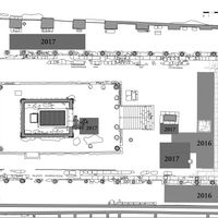 Fig. 4. Sanctuary of Apollo: recent excavations (2015-2017) (F. Giannella).
 Fig. 5. Sanctuary of Apollo: stratification of the western road (via di Apollo) (F. Giannella).
 Fig. 6. Limits of the sanctuary of Apollo.
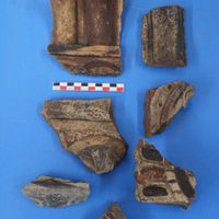 Fig. 7. Archaic architectural terracotta from the new excavations in the sanctuary of Apollo.
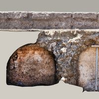 Fig. 8. First corridors of the large cistern in the forecourt of the sanctuary of Apollo (F. Giannella).
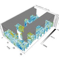 Fig. 9. Three-dimensional dataset of radar profiles and slice-maps of the temenos.
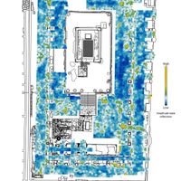 Fig. 10. GPR survey in the temenos. Time-slice relative to 0.50 m depth.
 Fig. 11. GPR survey in the temenos. Time-slice relative 0.80 m depth.
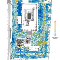 Fig. 12. GPR survey in the temenos. Time-slice relative to 1.00 m depth.
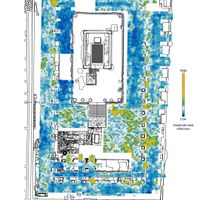 Fig. 13. GPR survey in the temenos. Time-slice relative to 1.10 m depth.
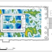 Fig. 14. GPR survey in the podium. Time-slices relative to depths between 0.40 and 0.70 m.
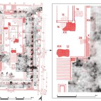 Fig. 15. Overlap of the De Caro excavations map to the GPR mapping. On the right, particular zoom on the east side of the podium.
 Fig. 16. Architectural terracotta found during the Maiuri excavations in the sanctuary of Apollo (drawing R. Oliva).
 Fig. 17. Radar section acquired along the western portico of the temenos. The arrows indicate some of the reflections to be attributed to the sequence of road levels identified by the archaeological excavations (2017) in the southern sector, and which suggest its continuation also in the northern half. To the progressive metric 7 and 32, structural residues referable to retaining walls.
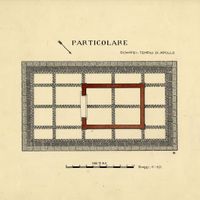 Fig. 18. Podium of the temple: 'vespaio' inside (relief R. Oliva).


References
- Anniboletti, L., V. Befani and P. Boila, 2009. ‘Progetto “Rileggere Pompei”: per una nuova forma urbis della città. Le indagini geofisiche nell’area non scavata e l’urbanizzazione del settore orientale’, in Fold&r 148, 1-11.
- Arthur, P., 1986. ‘Problems of the Urbanization of Pompeii: Excavations 1980–1981’, in Antiquaries Journal 66(1), 29–44.
- Boschi, F. (ed.), 2016. Looking to the future, caring for the past. Preventive archaeology in theory and practice. Bologna: Bononia University Press.
- Boschi, F., 2020. Archeologia senza scavo. Geofisica e indagini non invasive. Bologna: Bononia University Press.
- Conyers, L.B. and D. Goodman, 1997. Ground-Penetrating Radar. An Introduction for Archaeologists. Altamira Press
- De Caro, S., 1986. Saggi nell’area del Tempio di Apollo a Pompei. Scavi stratigrafici di A. Maiuri nel 1931-32 e 1942-43, AIONQuad.
- Deiana, R., 2019. ‘The contribution of geophysical prospecting to the multidisciplinary study of the Sarno
- Baths, Pompeii’, in Journal of Cultural Heritage 40, 274-279.
- Demauro, T., 2020. Pompei 1748-1861. Storia dei restauri, Studi e ricerche del Parco Archeologico di Pompei 44, Roma.
- Di Maio, R., M. Fedi, M. La Manna, M. Grimaldi and U. Pappalardo, 2019. ‘The contribution of geophysical prospecting in the reconstruction of the buried ancient environments of the house of Marcus Fabius Rufus (Pompeii, Italy)’, in Archaeological Prospection 17.4, 259-269.
- Dobbins, J., Ball, L., Cooper, J., Gavel, S., Hay, S., 1998. ‘Excavations in the Sanctuary of Apollo at Pompeii, 1997’, in AJA 102 (4), 739–56.
- García y García L., 2006. Danni di guerra a Pompei. Una dolorosa vicenda quasi dimenticata, Roma.
- Maiuri, A., 1973. ‘Greci ed Etruschi a Pompei’, in Alla ricerca di Pompei preromana. Saggi stratigrafici. Napoli, 135-160.
- Ogden, J., Tucker, G., Hay, S., Kay, S., Strutt, K.D., Keay, S., Camardo, D. and Ellis, S., 2012. ‘Geophysical prospection in the Vesuvian cities’, in F. Vermuelen, S.J. Keay, G.-J. Burgers and C. Corsi (eds.), Urban Landscape Survey in Italy and the Mediterranean. Oxford: Oxbow, 114-125.
- Kay, S., L. Alapont and R. Albiach, 2018. ‘Investigating the archaeology of death at Pompeii. The necropolis and fugitives of the Nolan Gate’, in V. Nizzo (ed.), Antropologia e archeologia a confronto. ESS Editorial Service.
- Osanna, M., Rescigno C., cds. ‘Nuove indagini nel foro e nel santuario di Apollo’, in Studium erga populum. Studium erga sapientiam.
- Poehler, E.E, and S. J.R. Ellis, 2014. ‘The 2013 Season of the Pompeii Quadriporticus Project: Final Fieldwork and Preliminary Results’, in Fold&r 321, 1-10.
- Rescigno, C., 2016 (a), ‘Il Santuario di Apollo tra vecchie acquisizioni e nuove prospettive di ricerca’, in E. Lippolis, M. Osanna (eds.), I pompeiani e i loro dei. Culti, rituali e funzioni sociali a Pompei. Scienze dell’Antichità, 22. Roma: Quasar, 37-70.
- Rescigno, C., 2016 (b), ‘Apollo e Diana. Peripezie di scavo e fortuna museale di due bronzi pompeiani’, in M. Osanna, R. Cioffi, A. Di Benedetto, L. Gallo (eds.), Pompei e l’Europa. Milano: Electa, 134-143.
- Sassatelli, G., E. Giorgi, 2017. Pompei Intra-Extra. Archeologi dell’Università di Bologna a Pompei. Bologna: Bononia University Press.
- Silani, M., E. Giorgi, G. Bitelli, F. Boschi, A. Martellone, 2017. ‘Seeing into the past: integrating 3D documentation and non-invasive prospecting methods for the analysis, understanding and reconstruction of the ancient Pompeii. The case of the House of Obellio Firmo (IX, 14)’, Archeologia e Calcolatori 28.2, 361-367.
Notes
1. Rescigno 2016a, 2016b.
2. Maiuri 1973, De Caro 1986; Dobbins, Ball, Cooper 1998; Ball, Dobbins 2013; for Arthur excavations: Arthur 1986; Cottica, Curti 2008; for recent excavations: Rescigno 2016a and 2017.
3. Modern tunnels, before the Bourbon excavations, are probably also attested by the new excavations in the Regio V.
4. PAH I, 3, pp. 188, 191 (?), 192-195, 210-216, 218-219; PAH II, pp. 9-10, 69) and PAH III, pp. 9-12, 14-17, 35.
5. On the first restorations in the sanctuary of Apollo see Demauro 2020, pp. 106-111 with precise reconstruction of the restoration plans of the early nineteenth century and subsequent interventions.
6. Maiuri 1973.
7. De Caro 1986, tav. I (for the originals by Maiuri) and tav. II (junction table).
8. Danni di guerra 2006, pp. 110-112: The west porch was damaged in several bombardments, in particular in its NE corner; the perimeter N wall was demolished and part of the corresponding colonnade was destroyed, the so-called priest’s room was also destroyed (‘sacrestia’).
9. Arthur 1986.
10. Dobbins, Ball, Cooper 1998, in particular for the positioning fig. 4.
11. Rescigno 2016a; Osanna, Rescigno forthcoming.
12. De Caro 1986, pp. 9-10, quoting the excavation diary records a ‘filone di lapillo del 79’ AD discovered in place of the northern continuation of the wall, in which, as we have already observed, we can identify traces of one of the plundering tunnels that affected the area of the sanctuary.
13. De Caro 1986, tav. III.
14. In the extensive bibliography of geophysical surveys at Pompeii it can be noted that results were often achieved by implementing an integrated approach, in Regiones III and IX, by the Inter-University Project Rileggere Pompei (direction: F. Coarelli – University of Perugia, F. Pesando – University of Naples L’Orientale; cfr. Anniboletti et al. 2009); the insulae VIII.7.1-15 e I.1.1-10 by the Pompeii Archaeological Research Project: Porta Stabia of Cincinnati University (Odgen et ali. 2012; Poelher, Ellis 2014); at Porta Nola by research carried out by the British School at Rome (Kay et al. 2016); the Terme del Sarno by the University of Padua (Deiana 2019), and at the Casa di Marcus Fabius Rufus under the coordination of the Suor Orsola Benincasa University of Naples (Di Maio et al. 2010). The Bologna research team has carried out geophysical investigations in other areas of the Pompeii, in particular at the Casa di Obellio Firmo (IX, 14, 2-4) and in Regio IX,10 as part of the Grande Progetto Pompei - Piano della Conoscenza. In this latter survey, it was necessary to employ different investigation strategies for the different characteristics of the places investigated, and of the thickness of the volcanic deposits still present (for preliminary data see Silani et al. 2017; Sassatelli, Giorgi 2017).
15. Cfr. Boschi 2016 and 2020.
16. Among the most recent work of the University of Bologna on urban areas with a continuity of life or on ancient, multi-layered living quarters that have been investigated by geophysics, we recall in particular the cases of Ascoli and Senigallia, for the first category, and Agrigento - Hellenistic-Roman quarter and Pompeii, Casa di Obellio Firmo for the second (on the various experiences, Boschi 2020). In all these cases, the same acquisition strategy has been adopted as for the temple of Apollo and explained below in the text. This is a measurement method that may involve longer acquisition times, but for the purposes of higher and more controlled acquisition accuracy, which helps to cope with the complexities of multi-phase contexts.
17. Conyers, Goodman 1997.
18. De Caro 1986, p. 127 (transcript of the excavation diaries, here as in the news that is cited later).
19. De Caro 1986, p. 128.
20. De Caro 1986, p. 6, n. 2.
21. De Caro 1986, p. 128: 4th February: ‘Per disposizione del signor Sovrintendente si compie un altro saggio davanti all’angolo SW del podio del tempio fino a raggiungere il muro N dell’ultima cisterna, allo scopo di trovare tracce di un’eventuale costruzione di tufo, ma senza alcun risultato’.
22. It is now known that between a wall near the eastern side of the podium and the wall of Trittolemo runs an archaic road that makes it difficult to provide this unitary reconstructive hypothesis.
23. De Caro 1986, p. 142, saggio XV (o XVI?), tav. Ib.
24. De Caro 1986, tav. Ib. The excavation in question is reported with the number XV in the summary table of De Caro: tav. II.
25. De Caro 1986, tav. V.
26. De Caro 1986, tav. II, AP83.
27. De Caro 1986, pp. 13-14 e 18-19.
28. De Caro 1986, p. 13.