1. Introduction
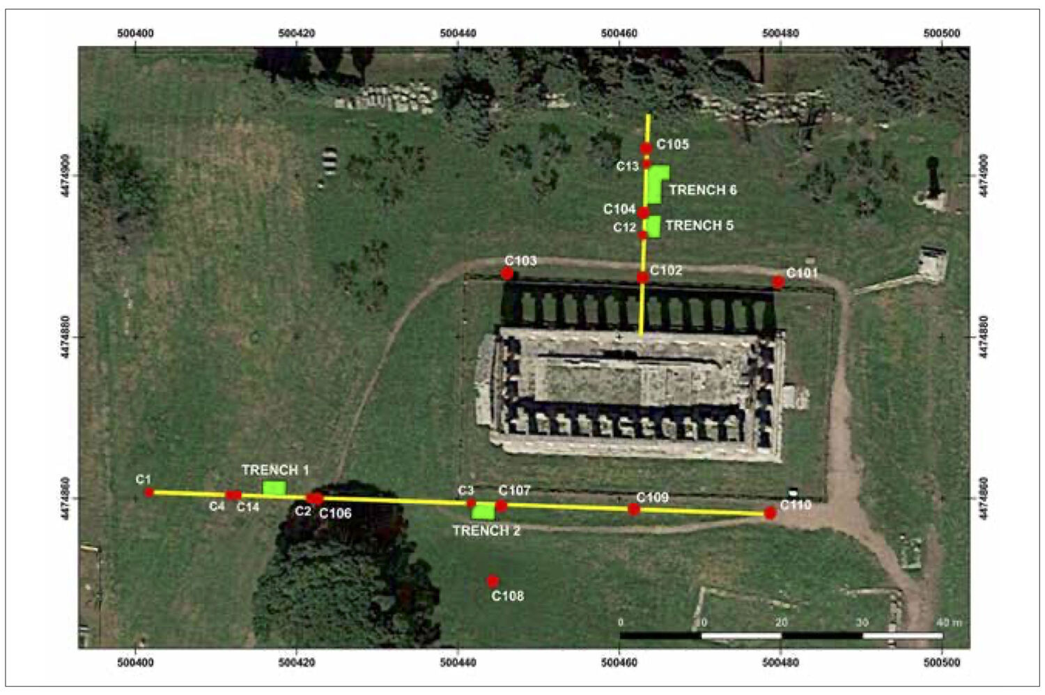
In August of 2017, there was the chance to start a new cycle of fieldwork at the site of the Doric temple that stands as the centerpiece of the north urban sanctuary at Paestum. Throughout most of the 20th century, it continued to be traditionally called the temple of Ceres; today it is commonly attributed to Athena. For fifty years, there had been a hiatus in investigations there. It was at the invitation of Gabriel Zuchtriegel, the Director of the Parco Archeologico di Paestum, that Rebecca Miller Ammerman began to assemble a team to return to the site. By July of 2019, we had managed to complete five seasons of fieldwork, and this made it possible for the first time to document the large artificial mound that covers an area of some 2,000 square metres on the north, west and south sides of the temple (Fig. 1). In turn, this now helped to explain why the temple of Athena stood in a position above the other monuments in the center of the ancient city. In a first report, “New light on the temple of Athena: reshaping the landscape,” we give an overview on the history of previous excavations at the site, on the methods used in our investigation and on what we learned from the first two years of the project (Ammerman and Ammerman 2019). In the original Italian version of the catalogue for the exhibition on Poseidonia Città d’Acqua (Zuchtriegel, Carter and Oddo 2019), our chapter was called “Nuova luce sul tempio di Atena: trasformare il paesaggio.” It will be recalled that our research design involved three complimentary lines of fieldwork: (1) geophysical prospection based on ground penetrating radar (GPR), (2) coring done in two different ways (first by hand using a Dutch soil auger and then by machine-made cores taken down to much greater depths in the ground), and (3) the excavation of four trenches dug in different places at the site (Fig. 1). More will be said about each of them below. The aim of this short article is to focus on the research design of the project and the ways in which we brought the three lines of investigation together in an integrated approach.
By way of introduction, it is worth saying a few words about what Zuchtriegel had in mind when he gave a green light to the new cycle of fieldwork at and around at the temple of Athena. Since the 1950s and 1960s, the field of classical archaeology has come a long way in terms of its methods as well as the basic conceptualization of the study of a site. In short, his aim was to update the investigation of the site where the temple stands. By applying new methods of research that were not in use fifty years ago, there would be a good chance to obtain significant gains in new knowledge about the site. In the case of previous excavations at the North Urban Sanctuary, large numbers of finds of considerable interest (in particular, votive terracottas) had been recovered, but the documentation of their proveniences was often poor (an obvious source of frustration for those archaeologists who tried to classify and publish the votive materials in more recent years) and limited attention had been paid previously to the organization of the sanctuary in spatial terms. Even at the most basic level, there were still open questions. For instance, while there had long been an awareness that the temple of Athena stood in a prominent position near the agora of the Greek city, it was still unclear whether this was due to the nature of things (the occurrence of a natural hill there) or else to human design (an artificial mound). In short, Zuchtriegel believed that it was time to address such questions. And in doing so, part of the plan would be for the archaeologists working at a site to engage in a dialogue with those visiting the Parco Archeologico.
To put it another way, an archaeological park should be today more than just a quiet resting place for monuments. It should be a more animated place where the archaeologist is conducting fieldwork to gain a better understanding of the past. Toward this end, there would be a poster on display at each of our trenches (Fig. 2), which would include the name of the project (the North Urban Paestum Project or NUPP in our case), the institutions involved in the research, and its aims. In addition, the idea was for a member of our team each day to present on-site a short talk on such things as the aims of the research, what was currently coming to light at the site and the approach that we were taking to the work. When it was my turn, I would outline the three steps in our fieldwork – prospection, coring and excavation – and then point out the parallel with the same sequence in medicine today: first scanning, next endoscopy and finally surgery on a small scale (if called for). In terms of cultural heritage, archaeologists today would like to work in less invasive ways than their predecessors.
In medicine and archaeology, such an approach is seen today as both more efficient and more comprehensive in scope than what was done before. One of the challenges in both fields is, of course, the design and coordination in the sequence of steps. In the case of archaeology, the weakest step at the present time is often the endoscopic one -- coring. There are still comparatively few archaeologists with experience in this line of investigation, since it calls for training in soil science and geomorphology. On the other hand, a specialist who comes from the earth sciences often lacks a good grasp of the archaeological questions at stake. And at the organizational level, there is a further complication that arises in countries such as Italy, Greece or Spain, whose systems for awarding archaeological permits do not foresee the need for all three of these three steps in a given project (there are different kinds of permits for an excavation, survey work, geophysical prospection and coring). At Paestum, we managed to get around this bureaucratic bottleneck since the matter of permits is now placed more directly in the hands of the person who directs the park. Here it is worth adding that this article stems from a paper given at the 38th International Mediterranean Survey Workshop held at Groningen in November of 2019. It was the first of four papers presented at the session on Multi-Method Approaches – a topic of notable interest these days. Given by Albert Ammerman, Federica Boschi, Enrico Giorgi and Michele Silani, the paper was called “Reshaping the landscape: taking an integrated approach to fieldwork at the temple of Athena (Paestum).” In other words, it was a case study that highlighted what could learn at a major classical site by adopting a new research design involving the three lines of investigation mentioned above.
2. The Site at first Sight and the Members of the Team
When a person today visits the temple of Athena at Paestum, it is difficult to see the site as a whole. This is due to a combination of factors as explained below. Most archaeologists or others who visit the site are not cognizant of this state of affairs. They are quite content to look at an impressive temple that has been standing there for the last twenty-five centuries. If one takes stock of the situation more attentively, what one finds is a site that is hemmed in by trees and fences today. On the east side, there is, for example, a tall fence (together with a number of large trees) that is located at a distance of 50 m from the temple’s eastern façade. This security fence runs all along the road that delimits the east side of the park. On the north side, there is another fence in combination with a row of tall trees standing at a distance of 30 m from the north wall of the temple. In other words, it is almost impossible to see the site from the north side. Turning to the west, one encounters two groups of small trees at distances of respectively 20 m and 40 m from the northwest corner of the temple. And behind them is yet another fence together with a tall copse of canes at a distance of 70 m from the temple’s western façade. In addition at a distance of 30 m from the southwest corner of the temple, there is a large maritime pine tree that further obstructs looking at the site from the west. The only side that offers a good line of sight at a good distance is the southern one. But it too is compromised by the maritime pine tree mentioned above as well as by two other large trees standing some 40 m south of the temple’s southeast corner (Fig. 3). For most of the day, the three tall pine trees cast long dark shadows over the area on the south side of the temple making it difficult to read the relief there
In this context, it should not come as a surprise that the question of whether the temple rests on a natural hill or else an artificial mound drew so little attention in the last thirty years. It was, in some ways, simply a matter of visibility. It was only in August of 2017, when the GPR coverage was taking place (Fig. 4) and I happened to sit at a table outside the Bar Museo for a coffee break, that I could finally see in a clear way (guided by the horizontal bar at the top of the fence in Fig. 3) that the temple stands on an artificial mound and that the best working hypothesis for us to adopt was that it was created by design. Viewed in profile from a proper distance, it did not look like a natural feature on a travertine plain. Even though I had walked over the site a number of times, it was necessary to step back in order to recognize more clearly that what we were dealing with was a low artificial mound. While I had been thinking about the idea for some time, there was finally the chance to “see” it with my own eyes. This was one of those moments of recognition that the archaeologist lives for. In most cases, one has to spend much more time in the field doing survey work to find the site of particular interest. In our case, the temple has been well known to scholars in Europe since the time of the celebrated veduta of the temple produced by Giambattista Piranesi and his son in the late 18th century. On the other hand, it seems to show no awareness of the mound itself. In our rare case in the field of archaeology where the discovery of a site was made well before our time, there is the irony that the research question to address came into focus by taking a coffee break. Now we could turn our full attention to developing a good strategy to study the size of the mound and how it was built.
As mention before, and the aim of this article is to say more about how the five seasons of fieldwork fit together. Of no less importance for an archaeological project is the team that implements a research design. At this point, a few brief words need to be said, by way of introduction, about the members of our team and their contributions. The director of the project is Rebecca Miller Ammerman at Colgate University (for her previous work at Paestum and bibliography, see Ammerman 2002; Ammerman and Cipriani 1997); her three main tasks were (1) to deal with all official matters, (2) to organize, supervise and coordinate the study of the archaeological materials recovered from the fieldwork, and (3) to provide guidance on the goals, documentation and publication of the project as a whole. The person taking the lead in the development of the research design and the work done in the field was Albert J. Ammerman at Colgate University. His three main tasks were (1) the organization of the fieldwork including it logistics, (2) the supervision of the coring and excavations, and (3) the coordination of environmental studies done as part of the project. Jay Noller at Oregon State University took the lead in the environmental studies; his fields of specialization are soil science, geomorphology and coastal geology. Three scholars at the University of Bologna, who have often worked together before, likewise made valuable contributions to the project. They are respectively (1) Federica Boschi, a specialist in geo-physical prospect, (2) Michele Silani with a specialization in ancient topography, and (3) Enrico Giorgi, who did laser scans of the temple and took the lead in representing the University of Bologna in our official collaboration. In addition, those working on the team in 2018 and 2019 included three graduate students from the University of Venice (Elenora Delpozzo, Damiano Paris and Pier Giorgio Sovernigo), a photographer from Colgate University (Michael Holobosky) and a pottery specialist (Massimo Barretta). Finally, students from three universities (Colgate, Bologna and Venice) participated in the excavations.
3. GPS Survey: August 2017
The first season of fieldwork involved prospection by means of ground penetrating radar of the whole open area shown in Fig. 1, which amounts to just over 1 hectare. To our knowledge, no other survey of this kind has attempted to cover the space on all four side of the temple of Athena before. In Europe, it is now common for a new project in archaeology to begin with a non-destructive method of prospection such as magnetometry, electrical resistance and ground penetrating radar in order to learn more about the structures buried in the ground over the site as a whole. We had the good fortune to work with Federica Boschi, a leading figure in this type of research in Italy (Boschi 2016), as part of our collaboration with the University of Bologna. Michele Silani, who has extensive GIS experience, assisted her in the field (Fig. 4). It was based on Boschi’s advice that the method of GPR was selected. She also did the elaboration of the GPR data and the interpretation of the resulting radiogram imagery across the site. In retrospect, this was a new kind of site for her. She was used to working at sites of classical age where the patterns that one expects to encounter are rectilinear ones (roads and walls) and not a mound of large size with a more organic shape. Of particular interest was the question of whether or not the GPR survey could recognize the edges of the mound. A year later during the course of the first excavation season, we were able to document one of its edges, including its depth in the ground, on the east side of trench 1 (more on this below), and this is just what one can see, in retrospect, on the GPR imagery (Fig. 5). In some cases, it may take time and patience to come up with such a result. But this is what research is all about. Normally, prospection gives rise to the recognition of a buried structure, and the archaeologist then confirms the interpretation by means of excavation. In our case, the story happens to run the other way around.
4. Coring by Hand the east-west Transect: November 2017.
The second step in the fieldwork involved making cores to gain local knowledge about such things as the soils, the stratigraphic sequences and the position of the top of the bedrock in different parts of the site. Again, this line of investigation, like endoscopy in modern medicine, offers a more or less non-invasive way of obtaining firsthand knowledge about the nature of a site. The purpose of the coring was threefold: (1) the “ground truthing” of the GPR survey (check on the relationship between the prospection imagery and what occurs in the ground), (2) developing a local knowledge of soils and stratigraphy at different points on the landscape, and (3) working out the best places to make the first excavations. The work was carried out by Ammerman in collaboration with Noller, a soil specialist, and Silani, a specialist in ancient topography, who documented the positions and elevations of the respective core by means of a total station and also differential GPS. The cores were made by hand with a Dutch soil augur, using a range of different bits. Each core was taken down in a series of entries with the depth of each “cut” recorded on a form, where the various soils recovered were described as well. Samples were also taken of the different soils in a given core for further study at a later time. As part of the research design, a number of the cores were made along the line of the east-west transect on the south side of the temple (see Fig. 1), so that we could trace the profiles of such things as the top of the mound, its base and the top of the underlying travertine bedrock. In the case of core 3 on the transect near the southwest corner of the temple, we started by going down through a sequence of upper stratigraphic units, including the soil (tephra) of the AD 79 eruption of Vesuvius down to the top of the mound at a depth of 78 cm in the ground. Then, with considerable effort (Fig. 6), we continued down through its rocks until the core was eventually blocked by a mass of travertine at a depth of 170 cm. In making plans for the third field season, this was clearly just the kind of place we were looking for.
5. First Excavations: July 2018.
This brings us to the third step in the fieldwork: the excavation of the first two trenches (1 and 2) located to the west of the southwest corner of the temple and placed near each other on the east-west transect (Figs. 1-2). In the limited space available here, the plan is to mention only a few aspects of the work that we did at them (for more on the results of the third season, see Ammerman and Ammerman 2019: 57-58). For our present purposes, what are of chief interest are the considerations that led to the apt choice of these two places to excavate at the site. In the case of trench 1, its east side occurs, as we had planned, at the western edge of the mound. In the case of trench 2, there was the chance to dig down through the mound so that we could now document how it was built and also reach the buried land surface just below the mound. For a first excavation season, the choice of these two places, in combination with one another, could not have been better. Only a few of the factors that entered into the decision-making process will be mentioned briefly here. To start with, we wanted to avoid excavating too close to the temple and the risk of working in places where Maiuri and Sestieri had previously dug (the positions of their excavations are not well known; research on where they might have dug has been undertaken by Longo 2017 and by Longo and Pontrandolfo 2017). On the positive side, we knew from core 3 (mentioned in the previous section) that this was definitely a place on the mound and that it had not been excavated before (the tufaceous soil just above the mound, interpreted as linked with the AD 79 event of Vesuvius, appears to be in situ). In addition we had a value for the elevation of the top of the mound there. Based on the other cores made along the east-west transect line, there was also a good idea of the elevations of the top of the travertine bedrock in this part of the site. And from my own “reading” of the GPR imagery, there was the chance to discern some change in its patterns at a distance of around 25 m from the southwest corner of the temple. In short, the strategy was to dig trench 2 on the mound (at core 3) and place trench 1 near its western edge. By placing the two trenches fairly close together, this would facilitate the logistics of the third field season as well. In retrospect, while this was, in effect, the single most challenging decision to make in the research design as a whole, it turned out quite well. The excavation began in trench 1 where the team was introduced to the site and the methods to be used in the excavation, and then trench 2 was opened the following week.
In starting the new cycle of excavations, one of the aims was to be more systematic in terms of recovery and in recording spatial contexts of artefact, since they had been the weak suits of the previous digs that Maiuri and Sestieri had done at the site. Toward this end, the provenience of artifacts would be recorded in terms of their stratigraphy units and also their metre squares in a given trench. At the same time, all of the soils excavated would be sieved at two mesh sizes (1 cm and 2 cm respectively). In excavating the mound itself, we wished to avoid being selective and thus set out to recover everything of any size, so that a quantitative approach could be taken to its study. We soon found that the mound consists principally of large travertine masses with smaller pieces of travertine rocks and modest amounts of soil between them. Since all of the rocks of large size have irregular shapes and none of them has a worked face, it is better to call them “masses” and not “blocks.” We found no evidence that the masses were placed in regular courses or rows. On the contrary, there was the impression at first glance that the masses were thrown down in a rather disorderly way. Masses of large size and small size were often found next to one another. Moreover, the masses are usually in direct contact with one anther, as it was possible to show by recording the rock-chains in three of the metre squares of trench 2. In a given rock-chain, one can trace the rock-to-rock contacts between the masses (“clast-to-clast” in the language of the earth scientist) from the mound’s top all of the way down to its base. In effect, soil plays a limited role in the basic structure of the mound. When it was first laid down, there were many voids or gaps between the masses, and even today a few of them have survived and they can still be seen in the lowest part of the mound in trench 2. One of the main steps in documenting the excavation involved taking overhead photographs of the base of each mound-excavation unit after its larger masses had been exposed. Once the photographs were taken, elevations were recorded on the tops of the masses as well as on the soil at their bases in a given mound unit. Then each mass measuring 25 cm or more in length was collected individually, tagged (with its trench, metre square and stratigraphic unit), measured, and then moved to a storage area. In this way, there was the recovery of a total of 129 masses during the course of the excavation of trench 2 (Table 1). All in all, the third step in the research design went essentially as planned.
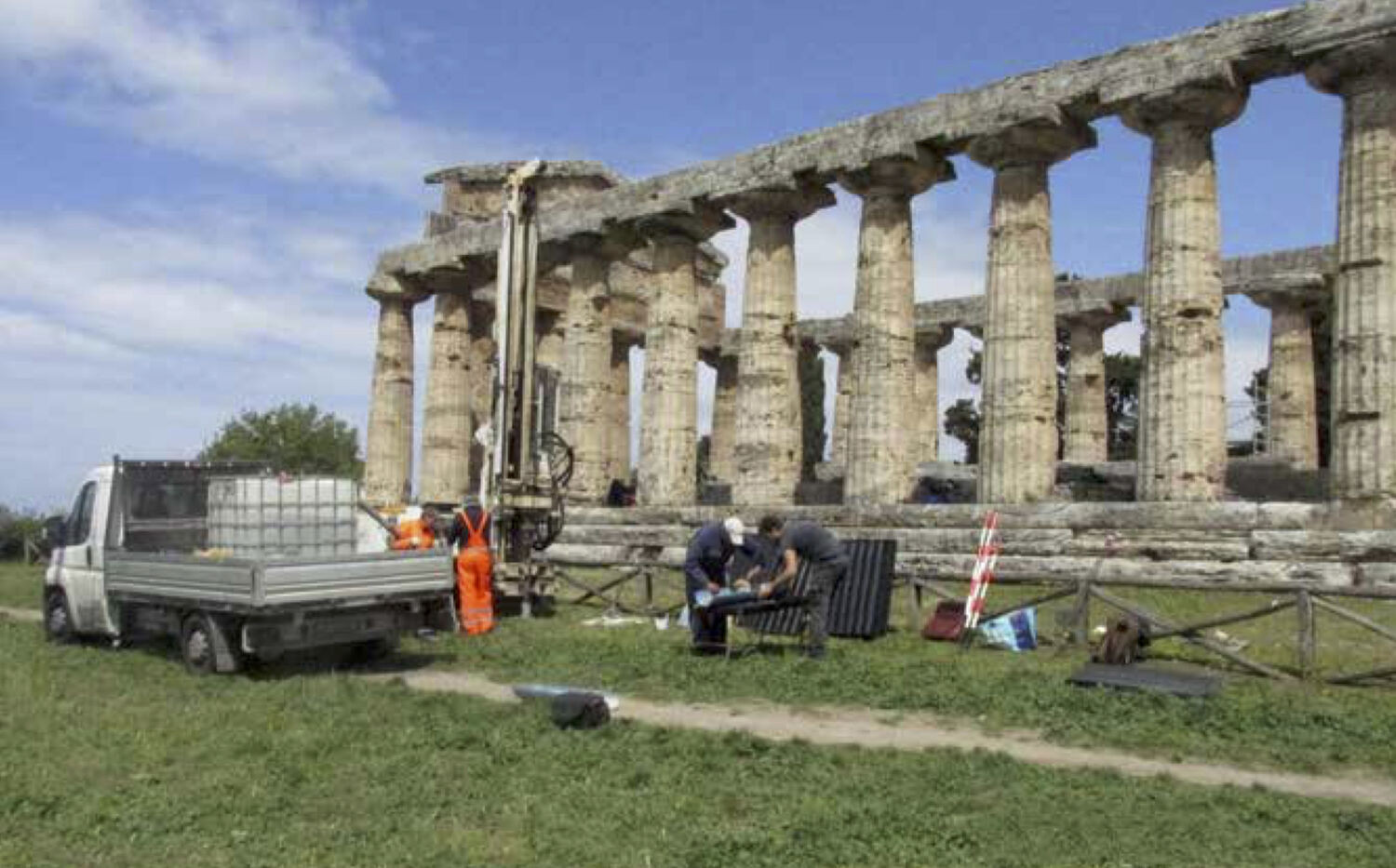
6. The Series of Machine-made Cores: April 2019
Turning to the fourth season of fieldwork, we were now interested in obtaining a broader picture of the mound’s layout in spatial terms and developing a better knowledge of the underlying geology at the site . The advantage of a machine-made core over one made by hand is, of course, twofold: (1) the core can be taken down to a much greater depth in the ground, and (2) it can go through the travertine masses in the artificial mound more easily. The plan for the fourth field season was to drill a series of ten cores at different points around the temple (for the location of cores 101-110, see Fig. 1). Figure 6 shows the work in progress at core 109 on the south side of the temple. All of the cores were made with a bit that measures 101 mm in diameter, and most of them were taken down to a depth of 10 m. Here the lead was taken by Albert Ammerman with his years of experience in directing work of this kind in places such as the Forum of ancient Rome and Piazza San Marco in Venice. Again, Jay Noller took part in this field season with the task of describing the soils and studying the respective stratigraphic sequences. In addition, he did most of the sampling of soils, sediments and rocks recovered in the cores with the assistance of Sandra Donicci, a specialist in micro-palaeontology at the CNR in Padua. Two graduate students from the University of Venice with an active interest in geo-archaeology, Damiano Paris and Pier Giorgio Sovernigo, also participated in the fieldwork.
In a given core, the main focus of our interest was in finding and documenting the following five things: (1) the presence of the reddish-brown paleosol associated with the AD 79 tephra (occurring in stratigraphic position above the mound), (2) the elevation of the top of the mound, (3) the elevation of the base of the mound, (4) the occurrence of a buried, anthropic paleosol immediately below the mound and (5) the elevation of the top of the travertine bedrock. We had the good fortune to find each of them in eight of the cores. The exceptions were cores 101 and 110 where the mound was not present. Both of these cores are located near the east end of the temple where the elevation of the top of the bedrock is higher. Here it is worth recalling that the second box of core 110 (from 5.00 m to 10.00 m depth) was used in the exhibition, Poseidonia città d’acqua, as well as its catalogue (no. 2 on p. 275) to illustrate the nature of geological formations of travertine at Paestum (on this topic, see also the good chapter by Vincenzo Amato 2019 in the catalogue). It is worth adding here that cores 102, 104 and 105 occur along the line of the north-south transect located on the north side of the temple (Fig. 1). These three cores made, in turn, a key contribution to the choice of where to place trenches 5 and 6 to be excavated two months later.
7. The second Season of Excavations: July 2019
This brings us to the fifth season of fieldwork at the North Urban Sanctuary (Fig. 7). In choosing where to excavate in 2019, we intentionally wished to move a fair distance from where we dug the year before. The plan from the start of the project was to see what was happening in a different part of the site during the fifth field season. Toward this end, we opened two new trenches (5 and 6) on the north-south transection (Fig. 1) with the aim of documenting the mound there and investigating the buried land surface that occurs just below it. By bringing together the evidence from these two trenches with that from cores 102, 104 and 105, there would be the chance to trace on this line the profiles of the 79 tephra, the top of the mound, it base and the top of the travertine bedrock over a distance of 16 m.
Essentially the same methods were used as in 2018. This time the decision was made to recover individually all of the masses of travertine that measure 20 cm or more in their longest dimension (that is, smaller than the 25 cm length used in 2018). By the end of the first excavation season, we had come to realize that the top part of the mound was made of smaller masses (often in the range of 20 to 30 cm) to give the mound’s surface a smoother finish. At the same time, there were improvements in the way that overhead photographs were made (Figs. 8-9), and “sweep in motion” imagery was taken more often during the excavation of the mound (done by Elenora Delpozzo). Furthermore, there was a surprise awaiting us in trench 5. The sizes of some of the masses in its lower part were much larger (in the range of 81 to 97 cm in length) than anything we had seen in trench 2. Since they were hard to move, we called them “monsters” (mostri in Italian; Fig. 10). In fact, two of the nine monsters in trench 5 were too heavy to remove from the trench, so we had to adjust our approach to excavating the lowest part of the mound. The work had to be done in three steps: (1) the side of the trench 5 without the two exceptionally large monsters was dug in the usual way; (2) the two heavy monsters were moved to this open place; and (3) the place on the opposite side of the trench was now free and it could now be excavated. In all, a total of 16 metre squares were excavated down to the base of the mound in trenches 5 and 6. On average, the number of masses (with a length of 20 cm or more) recovered from a given square metre turns out to be 30. In addition, we learned that the top of the mound between cores 102 and 105 on the north-south transect line has a slope of 1 in 8. In contrast, its slope between the east side of trench 2 and the edge of the mound in trench 1 is less steep: just 1 in 11. This means that notable differences (in terms of slope and the size of the largest masses) can be observed at various places on the mound. The suggestion is that no standard template was used (or else carefully followed) on the different sides of the mound. Instead, there was some local variation that may stem from such things as differences in the underlying relief or in the social organization of labor. As more excavations are carried out at the mound, it should be possible to gain a better understanding of how much variability there is from one place to the next and why it may occur. So after two seasons of excavation, it is already clear that one has to be careful and avoid speaking about the mound in normative terms. Finally, it is worth mentioning that a fair number of worked pieces of sandstone were found in a position just above the top of the mound on the northeast side of trench 6. Whether the sandstone derives from a workshop in this place or else from material discarded there after it had been worked elsewhere is a question of considerable interest that calls out for another season of excavation there.
8. Discussion
There has now been the chance to review the first five steps in the fieldwork at the site. This last section of the present article is not the place to repeat at length the gains in new knowledge that arose from the work. They have recently been presented in the closing section of the chapter in the catalogue (Ammerman and Ammerman 2019: 61-63). Without going into the respective arguments again, it is worth mentioning, in a nutshell, the following four points. First, the artificial mound is found on the north, west and south sides of the temple. With a width in around 25 m, it runs from just east of the middle of the temple on its north side all of the way around its west end to the middle of the temple’s south side. The mound does not occur at the eastern end of the temple, where the travertine bedrock stands in a high position. Second, the mound’s total area is approximately 2,000 square metres. Third, the mound consists of tens of thousands of travertine masses (each with a length of at least 20 cm), and the best estimate at the present time for the total number is on the order of 60,000 masses (Ammerman and Ammerman 2019: 62-63). All three of the numbers mentioned above should be regarded as first approximations; they can be refined when further work is done at the site. Fourth, the construction of the mound called for vast amounts of both human labor and travertine (commonly of lesser quality than the travertine rocks used in building the temple itself). In addition, there must have been a high level of organization to coordinate the two different kinds of work --on the temple and on the mound -- undertaken at essentially the same building site.
What I would like to do here is to discuss instead a different perspective on the work – one that considers the background that put us on the pathway to the research design. Given that it is an innovative one and not the approach commonly taken in classical archaeology, this may lead to a better understanding of where we were coming from and what enabled us to do the research in a comparatively short time as well as in a less invasive way. Toward this end, it is instructive to ask two basic questions. First, what made it possible for us to come up with such a research design? Secondly, how does one incorporate what one learns from a given field season in making plans for the next one so that the research design works? In the next part of this section, the plan is to outline some of my own research experience over the years in order to answer the first question. Then, the second question will be taken up in the last part of the discussion where the focus shifts to a few select aspects of strategy, method and people, which helped us in taking an integrated approach to the research.
In 1974, as the first step in a major project concerned with Neolithic settlement patterns at Acconia in Calabria, the region in the toe of southern Italy, we began a survey that soon led to the discovery of many early sites in an area near the coast with an inflating land surface linked with a sequence of paleo-dunes (Ammerman 1985). At the site of Piana di Curinga, we found evidence for several burnt wattle-and-daub huts of Stentinello age, which were buried at depths of around 1.5 m below the modern land surface. In 1977, the decision was made to conduct prospection based on magnetometry of the whole area of the settlement (ca. 2 hectares) in order to map the buried huts with their good magnetic anomalies. Next, in preparation for excavations in 1979, we made a series of more than 200 cores by hand using two Dutch soil augers and found that the cores were good at “ground truthing” the magnetic anomalies. In this way, we learned that 38 anomalies produced fragments of baked daub. At the same time, further coring was done at the site on a grid, which identified ten more places there with no magnetic anomaly but that did yield sintered daub. Finally, we excavated twelve of the places with evidence for both an anomaly and baked daub (from the coring), and all of them brought to light a collapsed wattle-and-daub structures dating to the 6th millennium cal. B.C. (Ammerman et al. 1988: fig. 2). In short, we already had a positive experience in bringing prospection, coring and excavation together in the late 1970s.
In 1985, as the head of a research group at the University of Parma, I was asked by the Italian government to coordinate the environmental studies to be done in conjunction with the excavation of three major sites in the heart of ancient Rome. One of them was the Forum where we now did pioneering work by drilling a series of deep cores on the transect line running from the Tabularium and to the Sepolcreto. Thus, we obtained the first profile of the natural relief of the Forum basin, and this led, in turn, to a new interpretation of how the Forum began as the consequence of a large project of land reclamation (Ammerman 1990). In 1992 Eugenio La Rocca (in charge of cultural matters on lands belonging to the City of Rome) asked me to organize the study of the many deep, machine-made cores taken at different places on the Capitoline Hill. This investigation yielded results of interest as well: the first proper map of its natural relief and new insight into the hill’s modification in order to make room for the large temple of Jupiter (Ammerman and Terrenato 1996). Then, in 1996, the City of Rome commissioned me to drill over the course of several years a series of 24 deep cores in the Velabrum, the valley between the Capitoline and Palatine Hills. Again, the fieldwork produced results of major interesrt such as the discovery of the clay beds for making the earliest roof tiles in Rome, which came to light beneath the headquarters of the Vigili Urbani (Ammerman et al. 2008a). In Venice, there was also the opportunity to drill a series of deep cores in Piazza San Marco on a transect line that ran from the waterfront (the Bacino) to the Clock Tower (Ammerman et al. 1995). Last but not least, in a project carried out at two Neolithic mound sites in Aegean Thrace (Greece), high-quality percussion cores took the lead in the fieldwork (Ammerman et al. 2008b). In short, part of my tool-kit as an archaeologist now included broad experience in making cores and working in collaboration with earth scientists
During the last thirty years, landscape archaeology has become a field of wider interest in the study of the classical world. Not only is more attention paid to placing sites and monuments in their environmental contexts but there is a growing awareness of the theme of landscape transformations. For instance, we now know that the creation of the Forum, the hub of early Rome, is linked with a large project of land reclamation, as mentioned before. And in the years of the Republic, there is now the case of the transformation of the landscape that derives from progressive encroachment on the east bank of the Tiber below the island (Ammerman 2018). The fieldwork that we conducted in the Agora of ancient Athena and Piazza San Marco in Venice led to the realization that landscape transformations had taken place in these two civic centers as well (for bibliography, see Ammerman 2011). This was one of the concepts that we brought to the project at Paesum, where one of the challenges to face was the uninspiring horizontality of the travertine plain there. By creating a mound and having the temple of Athena stand upon it, there was the possibility of adding a certain element of verticality to the civic center at Paestum. In sum, we had the background and the experience to put together a research design to document the transformation of the landscape at the North Urban Sanctuary.
This brings us to the second question and the matter of decision-making that is at the heart of fieldwork in archaeology. Only a few examples of the process of decision-making as it relates to such things as strategy, method and personnel will be presented in the limited space that is available here. When it comes to the fieldwork of a research project in archaeology, one is not dealing with a script or a score (something that is already written down), as in the case of a film or most musical performances. Instead, decision-making tends to be more organic and open-ended as a process in field archaeology. Taking the long view, the goal is for the results of the multiple lines of investigation to fit together in a coherent way as the project advances. Since the project would be carried out inside the Parco Archeologico di Paestum, and its Director, Gabriel Zuchtriegel, was fully behind us, it would make good sense to try to conduct five seasons of fieldwork over a span of two years. On one hand, this meant that we would have to adjust our other commitments and place our main emphasis on what was happening at Paestum. From my previous experience, I had learned that a project usually works best when we can be fully engage in it. If a project dibbles out slowly over the years, there is likely to be a loss of time, momentum and concentration.
As part of the overall strategy, the plan was to begin with prospection and cover all of the area in the immediate vicinity of the temple of Athena (the space shown in Fig. 1). The aim was to start by obtaining a broad and comprehensive “picture” of what might be buried in the ground there. As mentioned before and without going into technical details here, the survey involved the use of ground penetrating radar-- a method that would allow us to look for patterns at different depths in the ground. The choices of GPR as the method of prospection and of Boschi and Silani to do the fieldwork were both good ones. Indeed, this initial step in the project was directly linked with the official collaboration between Colgate University and the University of Bologna. At the time of the survey, there was, however, a certain sense of frustration that more in the way of structures (taking the form of walls and floors) could not be recognized in the survey area. As mentioned before, it was easier to read the imagery once trenches 1 and 2 were excavated in the summer of 2018. The western edge of the mound is definitely there to be seen in the imagery on the east side of trench 1 (Fig. 5). Looking back from where we stand today, the shortage of small structures on the mound and just outside of it now makes good sense to me. The centerpiece of the north urban sanctuary was the temple of Athena, which stood in an elevated position with a corona light around it created by the vast number of white travertine masses in the artificial mound (Ammerman and Ammerman 2019: 63). Placing small structures here and there on the mound would have actually worked against this visual effect. In retrospect, it is reasonable to think that the north urban sanctuary was meant to be seen as an open and uncluttered space, and this is what the GPR survey shows for the most part .
The making of the first cycle of cores at the site in November of 2017 was a rather straightforward matter. It was a time to explore what was in the ground in a non-invasive way. One of the key decisions at the start of the second step involved one that we had made before: that is, deciding where to place the east-west transect on the south side of the temple and then making a series of cores at regular intervals along it (Fig. 1). The place selected for the line was close to the mound (but not too close to avoid old excavations) and on the side of the mound facing the Agora in the 5th century B.C. As expected, Jay Noller took the lead in the description of the soils recovered from the cores and the study of the geomorphology at and around the site. As part of the second season of fieldwork, we also mapped the position and elevation of those comparatively few outcrops of travertine bedrock that can be seen on the land surface today. The most important core was, of course, the third one located near the southwest corner of the temple. In fact, we decided to make an adjacent core in the same place (this duplicate was called core 3’) to be sure that the stratigraphic sequence was correct. Perhaps the single most important decision that we would have to make on the project as a whole was the next one: choosing the right places to dig the first two trenches. As mentioned before, the aim was to place trench 1 at the western edge of the mound and trench 2 at or near core 3, where the plan was to dig down through the mound to its base and then excavate the soils of the buried land surface at the mound’s base. If we happened to choose by mistake a place where the mound was too thick, there was a good chance that we might not reach the base of the mound in the time allotted for the third field season. As we now began to move from the second field season to the third one, we began to realize we were about to make two do-or-die decisions. It was our good fortune that the right choices were made in both cases.
At the third step in the fieldwork, the real challenge was to dig down through the mound in trench 2. This required grinding out, in a systematic way, the recovery of each of the masses of travertine found in a given mound excavation unit and then repeating all of this again, as we moved down through the respective mound units until we reached the base of the mound. However, we soon began to realize that there was something missing in our research design. It concerns the rock-chains mentioned before. They provide a good example of the need to be open and to add something new in the field, which one might not have properly understood when the research was initially designed. In brief, we now realized that it was important to document the clast-to-clast contacts between the travertine masses in the mound.. The significance here is that soil plays only a minor role in the structure of the mound. Toward this end and without fully understanding what I was trying to do, I began to attach numbers in sequence to masses in contact with one another, starting at the top of the mound and working my way down. To my knowledge, the recording of rock-chains is not part of the common enterprise of archaeology. On the other hand, there are times when one has to think out of the box. In any event, Jay Noller now arrived at Paestum just in the nick of time and explained to me that rock-chains were “old hat” for the geologist. Accordingly, he took over the task of documenting the rock-chains in three of the meter squares of trench 2. At the same time, he recognized and recorded several voids (open spaces without soil), which occur between masses in contact with one another in the lower part of the mound. The moral of this story is twofold: first, a research design in archaeology should be regarded as an open-ended one, and second, it is important for a field project to have the right personnel on site so that research can move in a new direction when the occasion calls for it.
Given the many gains in new knowledge obtained during the third field season, it was time to start planning for the fourth field season and where to drill the deep, machine-made cores. To begin with, the new cores would have three advantages over the ones made by hand before: (1) they have a larger diameter and thus yield better samples; (2) they go down more easily through the hard travertine masses in the artificial mound; and (3) they reach greater depths in the ground and produce evidence on the geology of the site. On the positive side, I had a good deal of previous experience when it comes to the logistics of the heavy lifting that is associated with this kind of fieldwork. If we could successfully complete this step in the fieldwork, it would substantially increase our sub-surface documentation of the mound. Given that we had a separate grant to cover the costs of the coring, there was a fixed sum of money that was available for the fieldwork. This meant that the process of decision-making would involve a number of trade offs, including the choice of how many cores to make, the choice of where to place them and the choice of the depth of the respective cores. In short, there were many different possibilities to consider. In addition, there was the plan to drill several cores on the north-south transect (mentioned before) toward the selection the places where the two new trenches (5 and 6) would be excavated on the temple’s north side at the next step in the fieldwork. Without going into the details, what we eventually chose to do was to make ten cores (with most of them taken to a depth of 10 m) in the layout shown in Fig. 1. It will be noted that cores 102, 104 and 105 are located on the north-south transect and that trenches 5 and 6 were subsequently placed between them (with their west sides on the transect line as well). The coring went according to plan in April of 2019, and it now took our knowledge of the mound to a new and higher level
Only a few brief words will be said about the fifth and final step in the fieldwork: the excavations of trenches 5 and 6 in the summer of 2019. Again, we employed essentially the same methods in digging them. Only a few minor adjustments were made at this time: for example, collecting individually each travertine mass that measure 20 cm or more in length and improving the approach taken to overhead photography. By bringing the evidence from these two trenches together with what we had learned from cores 102, 104 and 105, we could now trace the profiles of things such as the elevations of the top and bottom of the mound over a distance of 16 m along the north-south transect. In all, a total of 16 metre squares were excavated down to the base of the mound in these two trenches. This then allowed us to estimate the average number of travertine masses for a given metre square in the mound. In turn, this value of 30 masses per metre square made it possible, at the first level of approximation, to estimate a total of ca. 60,000 masses (at least 20 cm long) for the mound as a whole. In short, we had come a long way from the first field season in August of 2017. There is, of course, still much more that remains to be done. The new cycle of fieldwork at the site has just begun. While the covid pandemic has put our sixth field season (an excavation in the summer of 2020) on hold, we continue to make plans for the time when fieldwork at Paestum will reopen.
 Fig. 1. Map showing the location of the north-south and east-west transect lines, trenches 1, 2, 5, and 6, the series of machine-made cores (101-110), and several of the cores made by hand on the transect lines. (M. Silani and M. Holobosky)
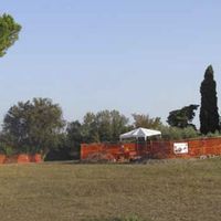 Fig. 2. View of trenches 1 and 2 on the west slope of the mound (see Fig. 1 for their locations on the east-west transect). Note the posters attached to the fences around both trenches (photo A.J. Ammerman)
 Fig. 3. View of the temple of Athens from the southeast (the Bar Museo) showing the shape of the artificial mound. Note the horizontal bar at the top of the fence and the large pine trees that obscure the view of the temple and mound from the south side. (photo A. J. Ammerman)
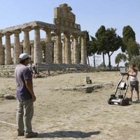 Fig. 4. View of the prospection survey done by Federica Boschi and Michele Silani; the method used is ground penetrating radar (GPR). (photo R.M. Ammerman)
 Fig. 5. Four GPR images of the area on the east side of trench 1. They are at depths in the ground of respectively 40, 80, 100 and 120 cm. At 100 cm, the western edge of the mound is documented (images produced by F. Boschi).
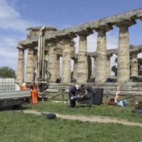 Fig. 6. View of core 109 being made on the south side of the temple of Athena. (photo A.J. Ammerman)
 Fig. 7. View of the north side of the temple of Athena and the excavations in trenches 5 and 6 in front of it (for their locations on the north-south transect, see Fig. 1). The overhead photograph is being taken by Michael Holobosky. (photo A.J. Ammerman)
 Fig. 8. Overhead photograph of the excavation in progress at trenches 5 and 6. One of the very large masses of travertine (called “monsters” in the text) has just been excavated, and it is now sitting on the west side of trench 5. (photo M. Holobosky)
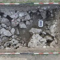 Fig. 9. Overhead photograph of the travertine masses exposed by the excavation in trench 5. (photo M. Holobosky)
 Fig. 10. In the diagram, the positions of the top and bottom of each of the large masses of travertine called “monsters” (M 1-9) and also large masses left in the sections at the end of the excavation (MS 1-6) are projected on the west section of trench 5, the north-south transect. This figure also places the mound in its basic stratigraphic context. (drawing E. Delpozzo)


References
- Amato, V. 2019. “Il territorio di Poseidonia–Paestum: una lunga storia di processi geologici e geomorfologici legati all’acqua.” Poseidonia Città d’Acqua edited by G. Zuchtriegel, Carter, P. and E.M. Oddo 41-49. Paestum: Pandemos.
- Ammerman, A. J. 1985. The Acconia Survey and the Obsidian Trade. London: Institute of Archaeology (UCL).
- ———. 1990. “On the origins of the Forum Romanum.” in AJA 94: 627-645.
- ———. 2011. “Relocating the center: a comparative study.” in Terrenato, N. and D.C. Haggis (eds.), State Formation in Italy and Greece Question the neo-evolutionist Paradigm, 256-272. Oxford: Oxbow.
- ———. 2018. “The east bank of the Tiber below the Island: two new advances in the study of early Rome.” in Antiquity 92: 398-409.
- Ammerman, A. J. and R.M. Ammerman 2019. “New light on the temple of Athena: re-shaping the landscape.” In Poseidonia Città d’Acqua edited by Zuchtriegel, G., Carter, P. and E.M. Oddo, 51-63. Paestum: Pandemos.
- Ammerman, A. J., Ammerman, A.J., N. Estratiou, M. Ntinou, L. Pavlopoulos, R. Gabrielli, K.D. Thomas and M.A. Mannino. 2008a. “Finding the early Neolithic in Aegean Thrace: the use of cores.” in Antiquity 82: 139-150.
- Ammerman, A. J., I. Iliopoulos, F. Bondioli, D. Filippi, J. Hilditch, A. Manfredini, L. Pennisi, and N.A. Winter. 2008b. “The clay beds in the Velabrum and the earliest tiles in Rome.” in Journal of Roman Archaeology 21: 7-30.
- Ammerman, A.J., G.D. Shaffer and N. Hartmann. 1988. “A Neolithic household at Piana di Curinga, Italy. in Journal of Field Archaeology 15: 121-140.
- Ammerman A.J., N. Terrenato. 1996. “Nuove osservazioni sul Colle Capitolino.” in Bullettino della Commissione Archeologica Comunale di Roma 97: 35-46.
- Ammerman, R.M. 2002. The Votive Terracottas. The Sanctuary of Santa Venera at Paestum 2. Ann Arbor: University of Michigan Press.
- Ammerman, R.M. and Cipriani, M. 1997. “Votive Offerings at Paestum: Continuity and Change in Cult Practice at the Temple of Ceres.” in AJA 101: 347.
- Boschi, F. (ed.) 2016. Looking to the Future, Caring for the Past. Preventive Archaeology in Theory and Practice. Proceedings of the 2103-2014 Erasmus IP Summer Schools in Preventive Archaeology: Evaluating sites and landscapes. Methods and techniques for evaluating the archaeological value. Bologna: Bononia University.
- Longo, F. 2017. “I metalli dell’ Athenaion. Dalla riscoperta alla ricontestualizzazione.” in Le armi di Athena. Il santuario settentrionale di Paestum (Catalogo della mostra, Paestum) edited by R. Graells, F. Longo and G. Zuchtriegel, 62-75. Naples: Arte’m.
- Longo, F. and A. Pontrandolfo. 2017. “Da Cerere ad Atena: per una storia della ricerca del santuario settentrionale.” in Le armi di Athena. Il santuario settentrionale di Paestum (Catalogo della mostra, Paestum) edited by R. Graells, F. Longo, and G. Zuchtriegel, 30-44. Naples: Arte’m.
- Zuchtriegel, G., Carter, P. and M.E. Oddo (eds.). 2019. Poseidonia Città d’Acqua. Paestum: Pandemos.